

Geography of Bhutan
Encyclopedia
|
||
| Continent Continent A continent is one of several very large landmasses on Earth. They are generally identified by convention rather than any strict criteria, with seven regions commonly regarded as continents—they are : Asia, Africa, North America, South America, Antarctica, Europe, and Australia.Plate tectonics is... |
Asia | |
| Subregion Subregion A subregion is a conceptual unit which derives from a larger region or continent and is usually based on location. Cardinal directions, such as south or southern, are commonly used to define a subregion.- United Nations subregions :... |
South Asia South Asia South Asia, also known as Southern Asia, is the southern region of the Asian continent, which comprises the sub-Himalayan countries and, for some authorities , also includes the adjoining countries to the west and the east... |
|
| Geographic coordinates | 27°30′N 90°30′E | |
| Area - Total - Water |
Ranked 142rd 38394 km² (14,824 sq mi) 0 km² (0 sq mi) (landlocked) |
|
| Coastline | 0 km (0 mi) | |
| Land boundaries | 1075 km (668 mi) | |
| Countries bordered | China 470 km (292 mi), India 605 km (376 mi) |
|
| Highest point | Gangkhar Puensum Gangkhar Puensum Gangkhar Puensum is the highest mountain in Bhutan and a strong candidate for the highest unclimbed mountain in the world with an elevation of 7,570 metres and a prominence of over 2990 metres. It lies on the border with China... , 7570 m (24,836 ft) |
|
| Lowest point | Drangme Chhu, 97 m (318 ft) | |
| Longest river | ||
| Largest inland body of water | ||
| Land Use - Arable land - Permanent crops - Other |
2.3% 0.43% 97.27% (2005 est.) |
|
| Irrigated Land | 400 km² (154.4 sq mi) (2003) | |
| Climate Climate Climate encompasses the statistics of temperature, humidity, atmospheric pressure, wind, rainfall, atmospheric particle count and other meteorological elemental measurements in a given region over long periods... : |
varies; tropical in southern plains; cool winters and hot summers in central valleys; severe winters and cool summers in Himalayas | |
| Natural resources | timber Timber Timber may refer to:* Timber, a term common in the United Kingdom and Australia for wood materials * Timber, Oregon, an unincorporated community in the U.S... , hydropower, gypsum Gypsum Gypsum is a very soft sulfate mineral composed of calcium sulfate dihydrate, with the chemical formula CaSO4·2H2O. It is found in alabaster, a decorative stone used in Ancient Egypt. It is the second softest mineral on the Mohs Hardness Scale... , calcium carbonate Calcium carbonate Calcium carbonate is a chemical compound with the formula CaCO3. It is a common substance found in rocks in all parts of the world, and is the main component of shells of marine organisms, snails, coal balls, pearls, and eggshells. Calcium carbonate is the active ingredient in agricultural lime,... |
|
| Natural hazards | violent storms from the Himalayas are the source of the country's name, which translates as Land of the Thunder Dragon; frequent landslides during the rainy season | |
| Environmental issues | soil erosion; limited access to potable water | |
Bhutan
Bhutan , officially the Kingdom of Bhutan, is a landlocked state in South Asia, located at the eastern end of the Himalayas and bordered to the south, east and west by the Republic of India and to the north by the People's Republic of China...
is a sovereign nation, located towards the eastern extreme of the Himalayas
Himalayas
The Himalaya Range or Himalaya Mountains Sanskrit: Devanagari: हिमालय, literally "abode of snow"), usually called the Himalayas or Himalaya for short, is a mountain range in Asia, separating the Indian subcontinent from the Tibetan Plateau...
mountain range. It is fairly evenly sandwiched between the sovereign territory of two nations: first, the People's Republic of China on the north and northwest. There are approximately 470 kilometres of border with that nation's Tibet Autonomous Region
Tibet Autonomous Region
The Tibet Autonomous Region , Tibet or Xizang for short, also called the Xizang Autonomous Region is a province-level autonomous region of the People's Republic of China , created in 1965....
. The second nation is the Republic of India
India
India , officially the Republic of India , is a country in South Asia. It is the seventh-largest country by geographical area, the second-most populous country with over 1.2 billion people, and the most populous democracy in the world...
on the south, southwest, and east; there are approximately 605 kilometres with the states of Arunachal Pradesh
Arunachal Pradesh
Arunachal Pradesh is a state of India, located in the far northeast. It borders the states of Assam and Nagaland to the south, and shares international borders with Burma in the east, Bhutan in the west, and the People's Republic of China in the north. The majority of the territory is claimed by...
, Assam
Assam
Assam , also, rarely, Assam Valley and formerly the Assam Province , is a northeastern state of India and is one of the most culturally and geographically distinct regions of the country...
, West Bengal
West Bengal
West Bengal is a state in the eastern region of India and is the nation's fourth-most populous. It is also the seventh-most populous sub-national entity in the world, with over 91 million inhabitants. A major agricultural producer, West Bengal is the sixth-largest contributor to India's GDP...
, and Sikkim
Sikkim
Sikkim is a landlocked Indian state nestled in the Himalayan mountains...
, in clockwise order from the kingdom. Bhutan's total borders amount to 1,075 kilometres. The Kingdom of Nepal
Nepal
Nepal , officially the Federal Democratic Republic of Nepal, is a landlocked sovereign state located in South Asia. It is located in the Himalayas and bordered to the north by the People's Republic of China, and to the south, east, and west by the Republic of India...
to the west, the People's Republic of Bangladesh
Bangladesh
Bangladesh , officially the People's Republic of Bangladesh is a sovereign state located in South Asia. It is bordered by India on all sides except for a small border with Burma to the far southeast and by the Bay of Bengal to the south...
to the south, and the Union of Myanmar
Myanmar
Burma , officially the Republic of the Union of Myanmar , is a country in Southeast Asia. Burma is bordered by China on the northeast, Laos on the east, Thailand on the southeast, Bangladesh on the west, India on the northwest, the Bay of Bengal to the southwest, and the Andaman Sea on the south....
to the southeast are other close neighbours; the former two are separated by only very small stretches of Indian territory.
Bhutan is a very compact nation, but with just a small bit more length
Length
In geometric measurements, length most commonly refers to the longest dimension of an object.In certain contexts, the term "length" is reserved for a certain dimension of an object along which the length is measured. For example it is possible to cut a length of a wire which is shorter than wire...
than width. The nation's territory totals an approximate 46,500 square kilometres. Because of its inland, landlocked
Landlocked
A landlocked country is a country entirely enclosed by land, or whose only coastlines lie on closed seas. There are 48 landlocked countries in the world, including partially recognized states...
status, it controls no territorial waters
Territorial waters
Territorial waters, or a territorial sea, as defined by the 1982 United Nations Convention on the Law of the Sea, is a belt of coastal waters extending at most from the baseline of a coastal state...
. It is known as the "Switzerland of Asia" since its shape, area, and mountainous location are comparable to that of Switzerland. Bhutan's territory used to extend south into present-day Assam, including the protectorate
Protectorate
In history, the term protectorate has two different meanings. In its earliest inception, which has been adopted by modern international law, it is an autonomous territory that is protected diplomatically or militarily against third parties by a stronger state or entity...
of Cooch Behar
Cooch Behar
Cooch Behar is the district headquarters and the largest city of Cooch Behar District in the Indian state of West Bengal. It is situated in the foothills of the Eastern Himalayas and located at . Cooch Behar is the only planned town in North Bengal region with remnants of royal heritage...
, but, starting from 1772, the British East India Company
British East India Company
The East India Company was an early English joint-stock company that was formed initially for pursuing trade with the East Indies, but that ended up trading mainly with the Indian subcontinent and China...
began to push back the borders through a number of wars and treaties, severely reducing Bhutan's size until the Treaty of Sinchula of 1865, when some border land was ceded back. Later, many of these territories were permanently lost to British India under the Treaty of Punakha
Treaty of Punakha
The Treaty of Punakha was an agreement signed on January 8, 1910, at Punakha Dzong between the recently consolidated Kingdom of Bhutan and British India. The Treaty of Punakha is not a stand-alone document, but represents a modification of the Treaty of Sinchula of 1865, the prior working agreement...
.
Political geography
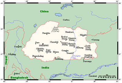
Bhutan is divided into 20 dzongkhagDzongkhag
A dzongkhag is an administrative and judicial district of Bhutan. The twenty dzongkhags of Bhutan are further divided into 205 gewogs. Some larger dzongkhags have one or more of an intermediate judicial division, known as dungkhags , which themselves comprise two or more gewogs...
s (districts), and further into 205 gewog
Gewog
A gewog, or geog refers to a group of villages in Bhutan. Gewogs form a geographic administrative unit below dzongkhag districts , and above thromde municipalities. Bhutan comprises 205 gewogs, which average 230 km² in area...
s (village blocks). Gewogs are in turn divided into numerous thromde
Thromde
A thromde is a third-level administrative division in Bhutan. The legal administrative status of thromdes was most recently codified under the Local Government Act of 2009, and the role of thromdes in elections in Bhutan was defined in the Election Act of 2008.-Thromde administration:Thromde...
s (municipalities) for administration.
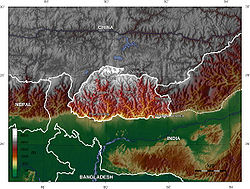
Natural geography
Himalayas
The Himalaya Range or Himalaya Mountains Sanskrit: Devanagari: हिमालय, literally "abode of snow"), usually called the Himalayas or Himalaya for short, is a mountain range in Asia, separating the Indian subcontinent from the Tibetan Plateau...
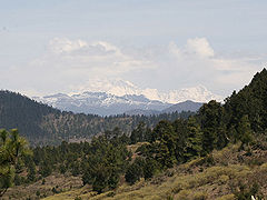
dominate the north of the country, where mountain peaks can easily reach 7000 metres (22,966 ft); the highest point in Bhutan is Gangkhar Puensum
Gangkhar Puensum
Gangkhar Puensum is the highest mountain in Bhutan and a strong candidate for the highest unclimbed mountain in the world with an elevation of 7,570 metres and a prominence of over 2990 metres. It lies on the border with China...
, which has the distinction of being the highest unclimbed mountain
Highest unclimbed mountain
The highest unclimbed mountain in a particular region or in the world is often a matter of controversy. In some parts of the world surveying and mapping are still not reliable, and there are not comprehensive records of the routes of explorers, mountaineers and local inhabitants.However, a major...
in the world, at 7570 metres (24,836 ft). Weather is extreme in the mountains: the high peaks have perpetual snow, and the lesser mountains and hewn gorges have high winds all year round, making them barren brown wind tunnels in summer, and frozen wastelands in winter. The blizzard
Blizzard
A blizzard is a severe snowstorm characterized by strong winds. By definition, the difference between blizzard and a snowstorm is the strength of the wind. To be a blizzard, a snow storm must have winds in excess of with blowing or drifting snow which reduces visibility to 400 meters or ¼ mile or...
s generated in the north each winter often drift southward into the central highlands
Highland (geography)
The term highland or upland is used to denote any mountainous region or elevated mountainous plateau. Generally speaking, the term upland tends to be used for ranges of hills, typically up to 500-600m, and highland for ranges of low mountains.The Scottish Highlands refers to the mountainous...
.
Below the rock and ice of the highest peaks lies an extensive arc of Eastern Himalayan alpine shrub and meadows
Eastern Himalayan alpine shrub and meadows
The Eastern Himalayan alpine shrub and meadows is a montane grasslands and shrublands ecoregion of Bhutan, China, India, Myanmar, and Nepal, which lies between the tree line and snow line in the eastern portion of the Himalaya Range.-Setting:...
, which contain, in additions to grasslands, a wide variety of rhododendron
Rhododendron
Rhododendron is a genus of over 1 000 species of woody plants in the heath family, most with showy flowers...
s and herbaceous plant
Herbaceous plant
A herbaceous plant is a plant that has leaves and stems that die down at the end of the growing season to the soil level. They have no persistent woody stem above ground...
s.
The highlands are the most populous part of the nation; the capital Thimphu
Thimphu
Thimphu also spelt Thimpu, is the capital and largest city of Bhutan. It is situated in the western central part of Bhutan and the surrounding valley is one of Bhutan's dzongkhags, the Thimphu District. The city became the capital of Bhutan in 1961...
lies in the western region. The region is characterised by its many rivers (flowing into India's Brahmaputra), its isolated valleys that house most of the population, and the expansive forests that cover seventy percent of the nation. The highlands have Eastern Himalayan subalpine conifer forests
Eastern Himalayan subalpine conifer forests
The Eastern Himalayan subalpine conifer forests is a temperate coniferous forests ecoregion which is found in the middle and upper elevations of the eastern Middle Himalayas, in western Nepal, Bhutan and northern Indian states including Arunachal Pradesh....
at higher elevations and Eastern Himalayan broadleaf forests
Eastern Himalayan broadleaf forests
The Eastern Himalayan broadleaf forests is a temperate broadleaf forest ecoregion found in the middle elevations of the eastern Himalayas, including parts of Nepal, India, and Bhutan...
at lower elevations. Winters are cold, summer are hot; the rainy season is accompanied with frequented landslides.
The valleys of Bhutan
Valleys of Bhutan
The valleys of Bhutan are carved into the Himalaya by Bhutan's rivers, fed by glacial melt and monsoon rains. As Bhutan is landlocked in the mountainous eastern Himalaya, much of its population is concentrated in valleys and lowlands, separated by rugged southward spurs of the Inner Himalaya...
are linked by a series of passes ("La" in Dzongkha). Between the Haa valley and Paro Valley is the Chele La (3780 metres (12,402 ft)). The Chele La is the highest pass crossed by a Bhutanese highway. The Lateral Road
Lateral Road
Bhutan's Lateral Road is its primary east-west corridor, connecting Phuentsholing in the southwest to Trashigang in the east. In between, the Lateral Road runs directly through Wangdue Phodrang, Trongsa, and other population centers...
from Thimphu to Punakha
Punakha
thumb|right|Punakha Dzong and the [[Mo Chhu]]Punakha is the administrative centre of Punakha dzongkhag, one of the 20 districts of Bhutan. Punakha was the capital of Bhutan and the seat of government until 1955, when the capital was moved to Thimphu. It is about 72 km away from Thimphu and it...
crosses the Dochu La (3116 metres (10,223 ft)), which features 108 chortens built to commemorate the expulsion of Assamese guerrillas. East of Wangdue Phodrang
Wangdue Phodrang
Wangdue Phodrang District is a dzongkhag of central Bhutan. This is also the name of the dzong which dominates the district, and the name of the small market town outside the gates of the dzong...
is the Pele La (3390 metres (11,122 ft)). Continuing to the east along the main highway, other major passes include the Yotang La, Shertang La, Wangthang La, Thrumshing La
Thrumshing La
Thrumshing La, also called Thrumshingla Pass" , is the second-highest mountain pass in Bhutan, connecting its central and eastern regions across the otherwise impregnable Donga range that has separated populations for centuries...
and Kori La (2298 metres (7,539 ft)).
The extreme southern strip of the nation consists mostly of Himalayan subtropical broadleaf forests
Himalayan subtropical broadleaf forests
The Himalayan subtropical broadleaf forests is an ecoregion that extends from the middle hills of central Nepal through Darjeeling into Bhutan and also into the Indian State of Uttar Pradesh...
that grade into the tropical plains of the Terai-Duar savanna and grasslands
Terai-Duar savanna and grasslands
The Terai-Duar savanna and grasslands is a narrow lowland ecoregion at the base of the Himalayas, about wide and a continuation of the Gangetic Plain colloquially called Terai in the Ganges Basin east to Nepal, then Dooars in West Bengal, Bangladesh, Bhutan and Assam east to the Brahmaputra River...
, more typical of India. It is largely agricultural land, producing mostly rice
Rice
Rice is the seed of the monocot plants Oryza sativa or Oryza glaberrima . As a cereal grain, it is the most important staple food for a large part of the world's human population, especially in East Asia, Southeast Asia, South Asia, the Middle East, and the West Indies...
. Only two percent of Bhutan is arable land
Arable land
In geography and agriculture, arable land is land that can be used for growing crops. It includes all land under temporary crops , temporary meadows for mowing or pasture, land under market and kitchen gardens and land temporarily fallow...
, with most of it focused here.
Centuries of isolationism
Isolationism
Isolationism is the policy or doctrine of isolating one's country from the affairs of other nations by declining to enter into alliances, foreign economic commitments, international agreements, etc., seeking to devote the entire efforts of one's country to its own advancement and remain at peace by...
, a small population
Demographics of Bhutan
This article is about the demographic features of the population of Bhutan, including population density, ethnicity, education level, health of the populace, economic status, religious affiliations and other aspects of the population....
, and topographical extremes have led to Bhutan maintaining one of the most intact ecosystem
Ecosystem
An ecosystem is a biological environment consisting of all the organisms living in a particular area, as well as all the nonliving , physical components of the environment with which the organisms interact, such as air, soil, water and sunlight....
s in the world. The country ranks amongst the top ten countries in the world in terms of species density (species richness per unit area). Over fifty-five hundred varieties of plant life exist, including around three-hundred medicinal ones. More than 770 species of avifauna and more than 165 species of mammals are known to exist, including many rare and endangered species like the red panda
Red Panda
The red panda , is a small arboreal mammal native to the eastern Himalayas and southwestern China. It is the only species of the genus Ailurus. Slightly larger than a domestic cat, it has reddish-brown fur, a long, shaggy tail, and a waddling gait due to its shorter front legs...
, snow leopard
Snow Leopard
The snow leopard is a moderately large cat native to the mountain ranges of South Asia and Central Asia...
, and golden langur.
Strategic location
Bhutan, situated between India and Chinese-occupied Tibet, is a potential Sino-IndianSino-Indian relations
Sino-Indian relations, also called Indo-China relations, refers to the bilateral relationship between the People's Republic of China and the Republic of India. China and India are the world's most populous states and also fastest growing major economies...
battleground; India currently has more political influence in the nation. This stems from two things: the fact that after the British granted sovereignty to their South Asia
South Asia
South Asia, also known as Southern Asia, is the southern region of the Asian continent, which comprises the sub-Himalayan countries and, for some authorities , also includes the adjoining countries to the west and the east...
n possessions, Bhutan, a protectorate
Protectorate
In history, the term protectorate has two different meanings. In its earliest inception, which has been adopted by modern international law, it is an autonomous territory that is protected diplomatically or militarily against third parties by a stronger state or entity...
, was briefly put under the administration of India, along with Sikkim. Independence
Independence
Independence is a condition of a nation, country, or state in which its residents and population, or some portion thereof, exercise self-government, and usually sovereignty, over its territory....
occurred quickly, but India maintained a special treaty relationship with the now-sovereign monarchy
Monarchy
A monarchy is a form of government in which the office of head of state is usually held until death or abdication and is often hereditary and includes a royal house. In some cases, the monarch is elected...
. The Indian Army
Indian Army
The Indian Army is the land based branch and the largest component of the Indian Armed Forces. With about 1,100,000 soldiers in active service and about 1,150,000 reserve troops, the Indian Army is the world's largest standing volunteer army...
patrols Bhutan's frontiers and has played a major role in the development of the country's road infrastructure. Additionally, the Government of India
Government of India
The Government of India, officially known as the Union Government, and also known as the Central Government, was established by the Constitution of India, and is the governing authority of the union of 28 states and seven union territories, collectively called the Republic of India...
continues to provide approximately 60% of Bhutan's government finances.
The second reason comes from the aggression against Tibet by China from 1949 to 1959; the Tibetans
Tibetan people
The Tibetan people are an ethnic group that is native to Tibet, which is mostly in the People's Republic of China. They number 5.4 million and are the 10th largest ethnic group in the country. Significant Tibetan minorities also live in India, Nepal, and Bhutan...
have strong cultural, historical, and religious connections to Bhutan.
Bhutan controls several strategic mountain passes through the Himalayas
Himalayas
The Himalaya Range or Himalaya Mountains Sanskrit: Devanagari: हिमालय, literally "abode of snow"), usually called the Himalayas or Himalaya for short, is a mountain range in Asia, separating the Indian subcontinent from the Tibetan Plateau...
, allowing travel between Tibet and Assam
Assam
Assam , also, rarely, Assam Valley and formerly the Assam Province , is a northeastern state of India and is one of the most culturally and geographically distinct regions of the country...
. These passes are also the only way into the kingdom, and, coupled with its centuries-old policies of isolationism
Isolationism
Isolationism is the policy or doctrine of isolating one's country from the affairs of other nations by declining to enter into alliances, foreign economic commitments, international agreements, etc., seeking to devote the entire efforts of one's country to its own advancement and remain at peace by...
, it has been called the "Mountain Fortress of the Gods." The heartland of Bhutan has never been successfully invaded; the British, while establishing a protectorate over the nation, did so with threats to the low-lying territories below the highlands.
Climate
Bhutan's climate is as varied as its altitudes and, like most of Asia, is affected by monsoons. Western Bhutan is particularly affected by monsoons that bring between 60 and 90 percent of the region's rainfall. The climate is humid and subtropical in the southern plains and foothills, temperate in the inner Himalayan valleys of the southern and central regions, and cold in the north, with year-round snow on the main Himalayan summits.Temperatures vary according to elevation. Temperatures in Thimphu, located at 2200 metres (7,218 ft) above sea level in west-central Bhutan, range from approximately 15 to 26 °C (59 to 78.8 F) during the monsoon season of June through September but drop to between about -4 C in January. Most of the central portion of the country experiences a cool, temperate climate year-round. In the south, a hot, humid climate helps maintain a fairly even temperature range of between 15 and 30 °C (59 and 86 F) year-round, although temperatures sometimes reach 40 °C (104 °F) in the valleys during the summer.
Annual precipitation ranges widely in various parts of the country. In the severe climate of the north, there is only about 40 millimetres (1.6 in) of annual precipitation—primarily snow. In the temperate central regions, a yearly average of around 1000 millimetres (39.4 in) is more common, and 7800 millimetres (307.1 in) per year has been registered at some locations in the humid, subtropical south, ensuring the thick tropical forest, or savanna. Thimphu experiences dry winter months (December through February) and almost no precipitation until March, when rainfall averages 20 millimetre (0.78740157480315 in) a month and increases steadily thereafter to a high of 220 millimetres (8.7 in) in August for a total annual rainfall of nearly 650 millimetres (25.6 in).
Bhutan's generally dry spring starts in early March and lasts until mid-April. Summer weather commences in mid-April with occasional showers and continues through the premonsoon rains of late June. The summer monsoon lasts from late June through late September with heavy rains from the southwest. The monsoon weather, blocked from its northward progress by the Himalayas, brings heavy rains, high humidity, flash floods and landslides, and numerous misty, overcast days. Autumn, from late September or early October to late November, follows the rainy season. It is characterised by bright, sunny days and some early snowfalls at higher elevations. From late November until March, winter sets in, with frost throughout much of the country and snowfall common above elevations of 3000 metres (9,843 ft). The winter northeast monsoon brings gale-force winds down through high mountain passes.
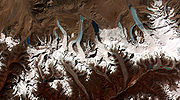
Glaciers
GlacierGlacier
A glacier is a large persistent body of ice that forms where the accumulation of snow exceeds its ablation over many years, often centuries. At least 0.1 km² in area and 50 m thick, but often much larger, a glacier slowly deforms and flows due to stresses induced by its weight...
s in northern Bhutan, which covered about 10 percent of the total surface area in the 1980s, are an important renewable source of water for Bhutan's rivers. Fed by fresh snow each winter and slow melting in the summer, the glaciers bring millions of litres of fresh water to Bhutan and downriver areas each year. Glacial melt adds to monsoon
Monsoon
Monsoon is traditionally defined as a seasonal reversing wind accompanied by corresponding changes in precipitation, but is now used to describe seasonal changes in atmospheric circulation and precipitation associated with the asymmetric heating of land and sea...
-swollen rivers, however, also contributes to flooding. Where glacial movement temporary blocks riverflows, downstream areas may be threatened by glacial lake outburst flood
Glacial lake outburst flood
A glacial lake outburst flood is a type of outburst flood that occurs when the dam containing a glacial lake fails. The dam can consist of glacier ice or a terminal moraine...
s (GLOFs), also called jökulhlaup
Jökulhlaup
A jökulhlaup is a glacial outburst flood. It is an Icelandic term that has been adopted by the English language. It originally referred to the well-known subglacial outburst floods from Vatnajökull, Iceland which are triggered by geothermal heating and occasionally by a volcanic subglacial...
s.
Bhutan's glaciers are melting. A 2008 United Nations
United Nations
The United Nations is an international organization whose stated aims are facilitating cooperation in international law, international security, economic development, social progress, human rights, and achievement of world peace...
report suggested that due to rising temperatures, glaciers in Bhutan were retreating at a rate of 30–40 meters per year, poised to make many lakes burst their banks and send millions of gallons of floodwater downstream. This among many other climate-related issues
Environmental issues in Bhutan
There are a number of environmental issues in Bhutan. Among Bhutan's most pressing issues are traditional firewood collection, crop and flock protection, and waste disposal, as well as modern concerns such as industrial pollution, wildlife conservation, and climate change that threatens Bhutan's...
identified in the report prompted the regional association of government ministers to establish the Southeast Asia Regional Health Emergency Fund in Thimphu
Thimphu
Thimphu also spelt Thimpu, is the capital and largest city of Bhutan. It is situated in the western central part of Bhutan and the surrounding valley is one of Bhutan's dzongkhags, the Thimphu District. The city became the capital of Bhutan in 1961...
in September 2007. Similarly, the member nations of South Asian Association for Regional Cooperation
South Asian Association for Regional Cooperation
The South Asian Association for Regional Cooperation is an organisation of South Asian nations, founded in December 1985 by Ziaur Rahman and dedicated to economic, technological, social, and cultural development emphasising collective self-reliance. Its seven founding members are Bangladesh,...
(SAARC) adopted bilateral agreements including measures on climate change and glaciers at its summit in April 2010.
The 2008 UN report also indicated Himalayan glaciers would melt within 25 years, however Prime Minister Jigme Thinley expressed a more dim outlook in a press conference in late March 2010, stating, "Our glaciers are withdrawing very fast and we have reasons to worry that they may in fact disappear not in 2035, but even earlier."
Lakes
Bhutan is home to at least 59 natural mountain lakes as well as some 2,674 glacial lakeGlacial lake
A glacial lake is a lake with origins in a melted glacier. Near the end of the last glacial period, roughly 10,000 years ago, glaciers began to retreat. A retreating glacier often left behind large deposits of ice in hollows between drumlins or hills. As the ice age ended, these melted to create...
s; about 25 of these glacial lakes are potential GLOF hazards.
Non-glacial lakes in Bhutan cover a total of about 4250 hectares (16.4 sq mi). Most are located above an altitude of 3500 metres (11,482.9 ft), and most have no permanent human settlements nearby, though many are used for grazing yaks and may have scattered temporary settlements.
River systems
Sankosh
Sankosh is a river that rises in northern Bhutan and empties into the Brahmaputra in the state of Assam in India. In Bhutan, it is known as the Puna Tsang Chu below the confluences of several tributaries near the town of Wangdue Phodrang. The two largest tributaries are the Mo Chhu and Pho...
; the Wang Chhu
Raidak River
The Raidak River is a tributary of the Brahmaputra River, and a trans-boundary river, flows through Bhutan, India and Bangladesh.-Bhutan:...
; and the Amo Chhu. Each flows swiftly out of the Himalayas, southerly through the Dooars to join the Brahmaputra River
Brahmaputra River
The Brahmaputra , also called Tsangpo-Brahmaputra, is a trans-boundary river and one of the major rivers of Asia. It is the only Indian river that is attributed the masculine gender and thus referred to as a in Indo-Aryan languages and languages with Indo-Aryan influence...
in India, and thence through Bangladesh
Bangladesh
Bangladesh , officially the People's Republic of Bangladesh is a sovereign state located in South Asia. It is bordered by India on all sides except for a small border with Burma to the far southeast and by the Bay of Bengal to the south...
where the Brahmaputra (or Jamuna in Bangladesh) joins the mighty Ganges (or Padma in Bangladesh) to flow into the Bay of Bengal
Bay of Bengal
The Bay of Bengal , the largest bay in the world, forms the northeastern part of the Indian Ocean. It resembles a triangle in shape, and is bordered mostly by the Eastern Coast of India, southern coast of Bangladesh and Sri Lanka to the west and Burma and the Andaman and Nicobar Islands to the...
. The largest river system, the Drangme Chhu, flows southwesterly from India's state of Arunachal Pradesh
Arunachal Pradesh
Arunachal Pradesh is a state of India, located in the far northeast. It borders the states of Assam and Nagaland to the south, and shares international borders with Burma in the east, Bhutan in the west, and the People's Republic of China in the north. The majority of the territory is claimed by...
and has three major branches: the Drangme Chhu, Mangde Chhu, and Bumthang Chhu
Bumthang River
Bumthang River is a river in Bhutan. It joins the Tongsa Chhu or Mangde Chhu in southern Bhutan and the combined stream flows into the Manas River....
. These branches form the Drangme Chhu basin, which spreads over most of eastern Bhutan and drains the Tongsa and Bumthang valleys. In the Duars, where eight tributaries join it, the Drangme Chhu is called the Manas Chhu
Manas River
The Manas River is a transboundary river in the Himalayan foothills between southern Bhutan and India.It is named after Manasa, the serpent god in Hindu mythology.It is the largest river system of Bhutan, among its four major river systems; the other three are Amo Chu or Torsa, Wong Chu or Raidak,...
. The 320-kilometer-long Puna Tsang Chhu rises in northwestern Bhutan as the Mo Chhu
Mo Chhu
Mo Chhu is a major river in Bhutan. The word "Chhu" means "river" or "water" in Dzongkha, the official national language in Bhutan. The river rises in Gasa Dzongkhag near the border between Bhutan and Tibet. From there, the Mo Chhu flows generally southward to Punakha in central Bhutan, where it...
and Pho Chhu, which are fed by the snows from the Great Himalayan Range. They flow southerly to Punakha
Punakha
thumb|right|Punakha Dzong and the [[Mo Chhu]]Punakha is the administrative centre of Punakha dzongkhag, one of the 20 districts of Bhutan. Punakha was the capital of Bhutan and the seat of government until 1955, when the capital was moved to Thimphu. It is about 72 km away from Thimphu and it...
, where they join to form the Puna Tsang Chhu, which flows southerly into India's state of West Bengal
West Bengal
West Bengal is a state in the eastern region of India and is the nation's fourth-most populous. It is also the seventh-most populous sub-national entity in the world, with over 91 million inhabitants. A major agricultural producer, West Bengal is the sixth-largest contributor to India's GDP...
. The tributaries of the 370-kilometer-long Wang Chhu
Raidak River
The Raidak River is a tributary of the Brahmaputra River, and a trans-boundary river, flows through Bhutan, India and Bangladesh.-Bhutan:...
rise in Tibet. The Wang Chhu itself flows southeasterly through west-central Bhutan, drains the Ha, Paro, and Thimphu valleys, and continues into the Duars, where it enters West Bengal as the Raigye Chhu. The smallest river system, the Torsa Chhu, known as the Amo Chhu in its northern reaches, also flows out of Tibet into the Chumbi Valley
Chumbi Valley
Chumbi Valley is a valley in Tibet at the intersection of India , Bhutan and China in the Himalayas. Two main passes between India and China open up here: the Nathu La Pass and Jelep La Pass....
and swiftly through western Bhutan before broadening near Phuntsholing
Phuntsholing
Phuentsholing is a border town in southern Bhutan, and is the administrative seat of Chukha District. The town occupies parts of both Phuentsholing Gewog and Sampheling Gewog. Phuentsholing lies opposite the Indian town of Jaigaon, and cross-border trade has resulted in a thriving local economy...
and then flowing into India.
Valleys
Bhutan's valleysValleys of Bhutan
The valleys of Bhutan are carved into the Himalaya by Bhutan's rivers, fed by glacial melt and monsoon rains. As Bhutan is landlocked in the mountainous eastern Himalaya, much of its population is concentrated in valleys and lowlands, separated by rugged southward spurs of the Inner Himalaya...
are carved into the Himalaya by its rivers, fed by glacial melt and monsoon rains. Much of the Bhutanese population is concentrated in valleys and lowlands, separated by rugged southward spurs of the Inner Himalaya. Despite modernization and development of transport in Bhutan
Transport in Bhutan
Transport in Bhutan comprises approximately of roads and two airports, Yongphulla Airport and Paro Airport, the latter of which serves international flights...
, including a national highway system, travel from one valley to the next remains difficult. Western valleys are bound to the east by the Black Mountains
Black Mountains (Bhutan)
The Black Mountains is a mountain range located in Bhutan. The current Jigme Singye Wangchuck National Park was previously the Black Mountains park. Elevations run up to 15145 ft or 4617 meters. -References:...
in central Bhutan, which form a watershed between two major river systems, the Mo Chhu
Mo Chhu
Mo Chhu is a major river in Bhutan. The word "Chhu" means "river" or "water" in Dzongkha, the official national language in Bhutan. The river rises in Gasa Dzongkhag near the border between Bhutan and Tibet. From there, the Mo Chhu flows generally southward to Punakha in central Bhutan, where it...
(Sankosh River) and the Drangme Chhu. Central valleys are separated from the east by the Donga Range. The more isolated mountain valleys protect several tiny, distinct cultural and linguistic groups
Languages of Bhutan
There are over nineteen languages of Bhutan, all members of the Tibeto-Burman language family, except for Nepali which is Indo-European. Dzongkha, the national language, is the only language with a native literary tradition in Bhutan, though Lepcha and Nepali are literary languages in other countries...
.