

Raidak River
Encyclopedia
The Raidak River is a tributary of the Brahmaputra River
, and a trans-boundary river
, flows through Bhutan
, India
and Bangladesh
.
. In its upper reaches it is also known as the Thimphu Chhu. The main river is a rapid stream, running over a bed of large boulders. Between Thimphu
and the confluence with the Paro Chhu
, the course of the river is not severely confined but, after leaving the confluence, it runs through a narrow defile between very steep cliffs. It subsequently flows southeast through a comparatively open valley, its course strewn with large boulders against which the water foams violently. It is joined by several small tributaries flowing from nearby mountains. Just above Paro Dzong a considerable feeder, the Ta Chhu, joins it from the left. To the west, the Ha Chhu
drains into the Wong Chhu. At Tashichho Dzong the bed of the river is about 2121 metres (6,958.7 ft) above sea level and at the point of its exit in the Dooars its elevation is only 90 metres (295.3 ft).
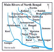 It debouches into the plains in Jalpaiguri district
and then flows through Cooch Behar district
in West Bengal
. The Raidak confluences with the Brahmaputra at chainage 327 km in Kurigram District
in Bangladesh
,where it is sometimes referred to Dudhkumar River.
The total length of the main river is 370 kilometres (229.9 mi) but along with its tributaries, it covers a length of nearly 610 kilometres (379 mi) in Bhutan alone.
hydel project, which harnesses the waters of the Wong Chhu or Raidak River, was historically one of the largest single investments undertaken in Bhutan, and it represented a major step toward exploiting the country's huge hydroelectric potential. It was built by India on a turnkey basis, with India providing 60% of the capital in a grant and 40% in a loan at highly concessional terms and conditions. In the arrangement, India receives in turn all the electricity generated from the project in excess of Bhutan’s demand at much cheaper prices than India’s generation cost from alternative sources. Located between Thimphu
and the Indian border, a 40 metres (131.2 ft) diversion dam was built at Chimakoti village, 1.6 kilometre (0.994196378639691 mi) upstream of the confluence of the Ti Chhu and Wong Chhu rivers. From the dam water was diverted through 6.5 kilometres (4 mi) long tunnels to a fall of more than 300 metres (984.3 ft) to Chukha power house for generation of electricity. Construction started in 1974 and completed in 1986-88.
is the biggest joint project between India and Bhutan so far, generating 4865 million kWh/yr. Tala is located in Chukha Dzongkhag in western Bhutan, The run-of-the-river project is being managed by Tala Hydroelectric Project Authority (THPA). It is located on the Wongchu River and, and is at a height of 860 metres (2,821.5 ft). The dam is 92m high and feeds a 22km-long headrace tunnel. An underground power house in Tala village has six 170MW generators. Three 440kV transmission lines stretch to the Indian border, since the power is being entirely supplied to India. Bhutan aims to export 10,000MW of power by the year 2020. Dam building started in 1998 and the project was commissioned in 2007.
Brahmaputra River
The Brahmaputra , also called Tsangpo-Brahmaputra, is a trans-boundary river and one of the major rivers of Asia. It is the only Indian river that is attributed the masculine gender and thus referred to as a in Indo-Aryan languages and languages with Indo-Aryan influence...
, and a trans-boundary river
Trans-boundary river
A trans-boundary river is a river that crosses at least one political border, either a border within a nation or an international boundary. The country of Bangladesh has the greatest number of these rivers, almost all of which cross national boundaries....
, flows through Bhutan
Bhutan
Bhutan , officially the Kingdom of Bhutan, is a landlocked state in South Asia, located at the eastern end of the Himalayas and bordered to the south, east and west by the Republic of India and to the north by the People's Republic of China...
, India
India
India , officially the Republic of India , is a country in South Asia. It is the seventh-largest country by geographical area, the second-most populous country with over 1.2 billion people, and the most populous democracy in the world...
and Bangladesh
Bangladesh
Bangladesh , officially the People's Republic of Bangladesh is a sovereign state located in South Asia. It is bordered by India on all sides except for a small border with Burma to the far southeast and by the Bay of Bengal to the south...
.
Bhutan
The Wong Chhu, or Raidāk, rises in the HimalayasHimalayas
The Himalaya Range or Himalaya Mountains Sanskrit: Devanagari: हिमालय, literally "abode of snow"), usually called the Himalayas or Himalaya for short, is a mountain range in Asia, separating the Indian subcontinent from the Tibetan Plateau...
. In its upper reaches it is also known as the Thimphu Chhu. The main river is a rapid stream, running over a bed of large boulders. Between Thimphu
Thimphu
Thimphu also spelt Thimpu, is the capital and largest city of Bhutan. It is situated in the western central part of Bhutan and the surrounding valley is one of Bhutan's dzongkhags, the Thimphu District. The city became the capital of Bhutan in 1961...
and the confluence with the Paro Chhu
Paro Chhu
The Paro Chhu is a river of western Bhutan. It is a tributary of the Wong Chhu, which is known as the Raidak in its lower reaches.-Course:...
, the course of the river is not severely confined but, after leaving the confluence, it runs through a narrow defile between very steep cliffs. It subsequently flows southeast through a comparatively open valley, its course strewn with large boulders against which the water foams violently. It is joined by several small tributaries flowing from nearby mountains. Just above Paro Dzong a considerable feeder, the Ta Chhu, joins it from the left. To the west, the Ha Chhu
Ha Chhu
The Ha Chhu is a river in west-central Bhutan, it is a tributary of the Raidak River .-Course:The Ha Chhu originates in a valley glacier on the south facing slope of the main Himalayas. The source area is located to the south of Chomo Lhari...
drains into the Wong Chhu. At Tashichho Dzong the bed of the river is about 2121 metres (6,958.7 ft) above sea level and at the point of its exit in the Dooars its elevation is only 90 metres (295.3 ft).
West Bengal and Bangladesh
Jalpaiguri District
Jalpaiguri district is the largest district of North Bengal, covering an area 6,245 km2. It is situated between 26° 16' and 27° 0' North latitudes and 88° 4' and 89° 53' East longitudes...
and then flows through Cooch Behar district
Cooch Behar District
Cooch Behar district is a district of the state of West Bengal, India, as well as the district's namesake town. During the British Raj, the town of Cooch Behar was the seat of a princely state of Koch Bihar, ruled by the Koch dynasty....
in West Bengal
West Bengal
West Bengal is a state in the eastern region of India and is the nation's fourth-most populous. It is also the seventh-most populous sub-national entity in the world, with over 91 million inhabitants. A major agricultural producer, West Bengal is the sixth-largest contributor to India's GDP...
. The Raidak confluences with the Brahmaputra at chainage 327 km in Kurigram District
Kurigram District
Kurigram is a district in Northern Bangladesh. It is located in the Rangpur Division.-Geography:Kurigram District is located in the northern region of Bangladesh along the border of India. The area of this district is 2,296.10 km² and population is 1,782,277...
in Bangladesh
Bangladesh
Bangladesh , officially the People's Republic of Bangladesh is a sovereign state located in South Asia. It is bordered by India on all sides except for a small border with Burma to the far southeast and by the Bay of Bengal to the south...
,where it is sometimes referred to Dudhkumar River.
The total length of the main river is 370 kilometres (229.9 mi) but along with its tributaries, it covers a length of nearly 610 kilometres (379 mi) in Bhutan alone.
Chukha hydel plant
The 336MW ChukhaChukha
Chukha District is one of the 20 dzongkhag comprising Bhutan. The major town is Phuentsholing which is the gateway city along the sole road which connects India to western Bhutan . Chukha is the commercial and the financial capital of Bhutan...
hydel project, which harnesses the waters of the Wong Chhu or Raidak River, was historically one of the largest single investments undertaken in Bhutan, and it represented a major step toward exploiting the country's huge hydroelectric potential. It was built by India on a turnkey basis, with India providing 60% of the capital in a grant and 40% in a loan at highly concessional terms and conditions. In the arrangement, India receives in turn all the electricity generated from the project in excess of Bhutan’s demand at much cheaper prices than India’s generation cost from alternative sources. Located between Thimphu
Thimphu
Thimphu also spelt Thimpu, is the capital and largest city of Bhutan. It is situated in the western central part of Bhutan and the surrounding valley is one of Bhutan's dzongkhags, the Thimphu District. The city became the capital of Bhutan in 1961...
and the Indian border, a 40 metres (131.2 ft) diversion dam was built at Chimakoti village, 1.6 kilometre (0.994196378639691 mi) upstream of the confluence of the Ti Chhu and Wong Chhu rivers. From the dam water was diverted through 6.5 kilometres (4 mi) long tunnels to a fall of more than 300 metres (984.3 ft) to Chukha power house for generation of electricity. Construction started in 1974 and completed in 1986-88.
Tala hydel plant
The 1,020 MW Tala hydroelectric projectTala Hydroelectricity Project
Tala Hydroelectricity project is the biggest hydroelectric joint project between India and Bhutan so far, generating 4865 GWh/yr. Tala is located in Chukha Dzongkhag in western Bhutan, a small constitutional monarchy in the Himalayas. It is located on the Wongchu River and, and is at a height of...
is the biggest joint project between India and Bhutan so far, generating 4865 million kWh/yr. Tala is located in Chukha Dzongkhag in western Bhutan, The run-of-the-river project is being managed by Tala Hydroelectric Project Authority (THPA). It is located on the Wongchu River and, and is at a height of 860 metres (2,821.5 ft). The dam is 92m high and feeds a 22km-long headrace tunnel. An underground power house in Tala village has six 170MW generators. Three 440kV transmission lines stretch to the Indian border, since the power is being entirely supplied to India. Bhutan aims to export 10,000MW of power by the year 2020. Dam building started in 1998 and the project was commissioned in 2007.