
Wayanad District
Encyclopedia
Wayanad District in the north-east of Kerala
, India
, was formed on November 1, 1980 as the 12th district by carving out areas from Kozhikode
and Kannur
districts. Kalpetta is the district headquarters as well as the only municipal town in the district. The region was known as Mayakshetra (Maya's land) in the earliest records. Mayakshetra evolved into Mayanad and finally to Wayanad. The Folk etymology of the word says it is a combination of Vayal (paddy field
) and Naad (land), making it 'The Land of Paddy Fields'. There are many indigenous tribal
s in this area. It is set high on the majestic Western Ghats
with altitudes ranging from 700 to 2100 m.
It is the least populous district in Kerala (out of 14).
, the Wayanad(Vayal+nadu(Tamil
/Malayalam)) forests have been inhabited for more than three thousand years.Wayanad has a powerful history
. Historians are of the view that organised human life existed in these parts, at least ten centuries before Christ. Countless evidences about New Stone Age civilisation can be seen on the hills of Wayanad. The two caves of Ampukuthimala located between Sulthan Bathery
and Ambalavayal
, with pictures on their walls and pictorial writings, speak volumes of the bygone era and civilisation. Recorded history of this district is available from the 18th century. In ancient times, this land was ruled by the Rajas of the Veda tribe. In later days, Wayanad came under the rule of the Pazhassi Rajahs of Kottayam royal dynasty. When Hyder Ali
becames the ruler of Mysore, he invaded Wayanad and brought it under his sway. In the days of Tipu
, Wayanad was restored to the Kottayam royal dynasty. But Tipu handed over the entire Malabarregion to the British, after the Sreerangapattanam truce, he made with them. This was followed by fierce and internecine encounters between the British
and Kerala Varma Pazhassi Rajah of Kottayam. When the Rajah was driven to the wilderness of Wayanad, he organised the war-like Kurichiya tribals into a sort of people's militia and engaged the British in several guerrilla type encounters. In the end, the British could get only the dead body of the Rajah, who killed himself somewhere in the interior of the forest. Thus, Wayanad fell into the hands of the British and with it came a new turn in the Home of this area. The British authorities opened up the plateau for cultivation of tea and other cash crops. Roads were laid across the dangerous slopes of Wayanad, from Kozhikode and Thalassery. These roads were extended to the cities of Mysore and Ooty through Gudalur. Through the roads poured in settlers from all parts of Kerala and the virgin forest lands proved a veritable goldmine with incredible yields of cash crops. When the State of Kerala came into being in November 1956, Wayanad was part of Kannur district. Later, south Wayanad was added to Kozhikode district. In order to fulfil the aspirations of the people of Wayanad for development, north Wayanad and South Wayanad were carved out and joined together to form the present district of Wayanad. This district came into being on November 1, 1980 as the 12 district of Kerala
comprising three taluks; Vythiri, Mananthavady, and Sulthan Bathery
.
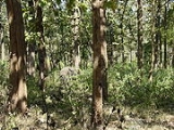
 Wayanad district stands on the southern tip of the Deccan plateau and its chief glory is the majestic rugged terrain of the Western ghats, with lofty ridges interspersed with dense forest, tangled jungles and deep valleys. Quite a large area of the district is covered by forest
but the continued and indiscriminate exploitation of the natural resource
s point towards an imminent environmental
crisis.
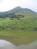
(2100 metres (6,890 ft)), Banasura peak (2073 metres (6,801 ft)), Brahmagiri
(1608 metres (5,276 ft)) are some of the important mountains in the district.
, one of the three east flowing rivers of Kerala, is an important tributary
of the Kaveri River
. Almost the entire Wayanad district is drained by Kabini and its three tributaries, the Panamaram
, Mananthavady, and Kalindy rivers. The Banasura Sagar Dam
is built on one of tributaries of the Kabini River.
(June to September) and North East monsoon (October to November). During the hot weather the temperature goes up to a maximum of 35 °C (95 °F) and during the cold weather the temperature goes down to 7 °C (45 °F). The greater temperature variation in the last 5–6 years is in the range of 18 °C (64 °F) to 28 °C (82 °F). The average rainfall is 2500 millimetres (98 in) per year.
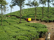
, tea
, cocoa, pepper
, plantain
and vanilla
are the main crop
s. Besides these cash crops, the most important crop in the district is rice
. Dam
s and aqueduct
s have been constructed to take water to the otherwise dry areas in the district. Price of land is going up even though Agrarian crisis.
In 2006 the Ministry of Panchayati Raj
named Wayanad one of the country's 250 most backward districts
(out of a total of 640
). It is one of the two districts in Kerala currently receiving funds from the Backward Regions Grant Fund Programme (BRGF).
were the only districts selected to receive the benefits under this scheme because of the acute need in these areas. The daily wage under NREGS at Rs. 125, regardless of gender, in Kerala is the highest among all the states. Work under NREGS includes building elephant trenches (crop-raiding by wild elephants is another problem in Wayanad), waterbodies, roads, etc. Due to a combination of the NREGS and measures undertaken by the state government, in 2007, the state reported 10 farmer suicides as opposed to 131 in 2004.
 According to the 2011 census
Wayanad district has a population
of 816,558, roughly equal to the nation of Comoros
or the US state of South Dakota
. This gives it a ranking of 482nd in India (out of a total of 640
). The district has a population density of 383 PD/sqkm . Its population growth rate
over the decade 2001-2011 was 4.6 %. Wayanad has a sex ratio
of 1035 females
for every 1000 males, and a literacy rate
of 89.32 %.
No. of Taluks: 3 (Mananthavady
, Sulthan Bathery
, and Vythiri)
No. of state Assembly Legislators: 3 (mananthavady, Sulthan Bathery, and Kalpetta
)
Lok Sabha
Representation: 1 (Wayanad constituency).
District Headquarters: Kalpetta
.
Other Important Towns: Sulthan Bathery
and Mananthavady
.
There are tribal populations in the area who still practice age-old customs and rituals and live a nomadic life. Some of the tribal populations include Paniya
s, Adiyas, Kattunayakan
and Kurichiya
ns. It is the district with the highest share in the adivasi
population (about 36%) of Kerala. Wayanad also has a large settler population. The Jains
from Karnataka came in the 13th century. The Hindu
Nairs from Kottayam-Kurumbranadu, in Kannur district, made an entry in the 14th century and established their feudal system. They were followed by Muslims. There were large scale migrations from southern Kerala in the early 1940s. Christians came in the 1950s from Travancore region. In the last few decades there was a complete marginalisation of the indigenous people. Alienated from their land, exploited by the settlers and neglected by the state, their struggle for rights to the land has so far been unsuccessful.
All the three legislative constituencies in Wayanad Distinct (Kalpetta
, Sulthan Bathery
and Mananthavady
)are part of the newly constituted Wayanad Lok Sabha Parliamentary constituency
. Mr. M I Shanavas
of Indian National Congress
is the present member of Parliament from Wayanad Loksabha Constituency
. The erstwhile North Wayanad constituency is now renamed as Mananthavady
. Smt. P.K.Jayalakshmi
represents Mananthavadi, Shri. M. V. Sreyams Kumar represents Kalpetta
and Shri. I.C. Balakrishnan represents Sulthan Bathery
in Kerala Legislative Assembly
(NH 212) passes through Wayanad district. Wayanad is well connected by road to various parts of Kerala and other neighbouring states. Buses go frequently between important centres like Mysore, Bangalore
, Ootty, etc. While travelling from Mysore on NH 212, at a place called Gundlupet
the road forks, one goes to Ooty and the other goes to Sultan Bathery, which is a prominent town of Wayanad. Buses are frequently available to Kozhikode
, Kannur
, Thalassery
, Vadakara, Gonikoppal
, etc. More than 50% of the traffic in and out of Wayanad passes through NH 212, mainly from Kozhikkode. The nearest railway station is at Kozhikode
, 75 km from Kalpetta
. Other railway stations near to Wayanad are Thalassery
(80 km from Mananthavadi), Kannur
(93 km from Mananthavadi) and Mysore(110 km from Mananthavadi & 115 km from Sultan Bathery). Kozhikode International Airport
at Karipur is the nearest airport. Kozhikode International Airport is at a distance of 95 km from Kalpetta
. Kannur International Airport
, under construction at Mattannur is at a distance of 70 km from Mananthavadi.
NH 212 passes through Bandipur National Park
and then through the Muthanga Wildlife Sanctuary
which is the Kerala
-Karnataka
state border. The roads are good except for some sections inside the Bandipur Forest
.
roads are used for reaching Wayanad from coastal towns & lower hilly towns of Kerala
:
1. From Thalassery
: Nedumpoil
-Periya Ghat road, which connects Kasargod, Kannur
, Thalassery
& Kuthuparamba
with Wayanad
2. From Kozhikkode: Thamarassery
-Lakkidi Ghat road, part of NH 212, which connects Kozhikkode and the rest of Kerala, south of Kozhikkode with Wayanad
3. From Vadakara : Kuttiady
-Pakramthalam Ghat road, which connects Thalassery
, Mahe, Vadakara
, Nadapuram
, Kuttiady
and Thottilpalam
with Wayanad
4. From Iritty
: Kottiyoor
-Ambayathode-Palchuram-Boys Town Ghat road, which connects lower hilly towns and villages of Kannur
and Kasargod districts with Wayanad. The towns are : Panathur, Udayagiri
, Cherupuzha
, Alakode
, Sreekandapuram
, Payyavoor
, Iritty
, Peravoor
, Kelakam
, Kottiyoor
, etc.
5. From Nilambur
: Vazhikkadavu
-Nadukani Ghat road, which connects Nilambur
, Palakkad
, Thrissur
and Perinthalmanna, with Wayanad.
), mullumurikku (Erthrina), several species of caussia and many other nondescript varieties are still preserved here and there, to give shade to the coffee plants. These trees give a dembalance of wilderness to the landscape of Wayanad. In a majority of coffee plantations, the age-old species are replaced by the silver-oak which is suited to the cold climate. This tree grows quickly and its cultivation is widespread among coffee
plantations for shade and for giving support to pepper. It is used for the plywood industry and thus is economical to the farmers. Eucalyptus grandis
, a shorter variety of eucalyptus, whose fragrant smell suffuses the very air around it, is cultivated on a large scale in certain parts of the district. Eucalyptus oil is extracted on commercial basis from its leaves.
Of the 20,864 hectares of reserve forest, the major portion is teak plantation. Arecanut palms and jack trees are also grown here. Tea is grown as an industry in large estates. The soil and climate of Wayanad are suitable for horiculture on commercial basis. For promoting the cultivation of vegetables and raising of orchards, the Kerala Agricultural University is running a Regional Agricultural Research Station at Ambalavayal.
With the clearing of forests, the diverse and bustling animal life, characteristic of the forests of Western Ghats, has vanished from Wayanad. One can still see the bonnet macaque
, slender loris
, mongooses, jungle cats, squirrels, jackals, hares, etc., in the limited forest areas. The world's most venomous snake, King Cobra
is also found here. Elephant
, bear
and other wild animals from the neighbouring wild life sanctuaries of Karnadaka and Tamil Nadu, stray into the Begur forest range and the forests around Muthanga, which is 20 kilometres away from the town of Sulthan Bathery. Karapuzha dam near menangadi-10 km, Banasurasagar dam 20 km from vythri. Today large game is found only in region that border with Karnataka and Tamil Nadu. Here there is one of the largest concentrations of wild Asiatic elephants in whole world. Tiger, bison, sambhar, spotted deer, boar, leopard, wild dog and other large mammals are also present in fairly decent numbers.
There are many educational institutions in Wayanad. A few are
Schools - 297
st josephs English higher secondary school
High Schools - 67
Vocational Higher Secondary Schools - 10
Higher Secondary Schools - 41
Colleges - 06
Polytechnic - 02
Industrial Training Institutes (ITI) - 02
Kerala
or Keralam is an Indian state located on the Malabar coast of south-west India. It was created on 1 November 1956 by the States Reorganisation Act by combining various Malayalam speaking regions....
, India
India
India , officially the Republic of India , is a country in South Asia. It is the seventh-largest country by geographical area, the second-most populous country with over 1.2 billion people, and the most populous democracy in the world...
, was formed on November 1, 1980 as the 12th district by carving out areas from Kozhikode
Kozhikode district
Kozhikode District , formerly Calicut, is a district of Kerala state, situated on the southwest coast of India. The city of Kozhikode, also known as Calicut, is the district headquarters. The district is 38.25% urbanised...
and Kannur
Kannur district
Kannur District is one of the 14 districts in the state of Kerala, India. The town of Kannur is the district headquarters, and gives the district its name. The old name Cannanore is the anglicised form of the Malayalam name Kannur. Kannur District is bounded by Kasaragod District to the north and...
districts. Kalpetta is the district headquarters as well as the only municipal town in the district. The region was known as Mayakshetra (Maya's land) in the earliest records. Mayakshetra evolved into Mayanad and finally to Wayanad. The Folk etymology of the word says it is a combination of Vayal (paddy field
Paddy field
A paddy field is a flooded parcel of arable land used for growing rice and other semiaquatic crops. Paddy fields are a typical feature of rice farming in east, south and southeast Asia. Paddies can be built into steep hillsides as terraces and adjacent to depressed or steeply sloped features such...
) and Naad (land), making it 'The Land of Paddy Fields'. There are many indigenous tribal
Tribe
A tribe, viewed historically or developmentally, consists of a social group existing before the development of, or outside of, states.Many anthropologists use the term tribal society to refer to societies organized largely on the basis of kinship, especially corporate descent groups .Some theorists...
s in this area. It is set high on the majestic Western Ghats
Western Ghats
The Western Ghats, Western Ghauts or the Sahyādri is a mountain range along the western side of India. It runs north to south along the western edge of the Deccan Plateau, and separates the plateau from a narrow coastal plain along the Arabian Sea. The Western Ghats block rainfall to the Deccan...
with altitudes ranging from 700 to 2100 m.
It is the least populous district in Kerala (out of 14).
History
According to archaeological evidenceArchaeology
Archaeology, or archeology , is the study of human society, primarily through the recovery and analysis of the material culture and environmental data that they have left behind, which includes artifacts, architecture, biofacts and cultural landscapes...
, the Wayanad(Vayal+nadu(Tamil
Tamil language
Tamil is a Dravidian language spoken predominantly by Tamil people of the Indian subcontinent. It has official status in the Indian state of Tamil Nadu and in the Indian union territory of Pondicherry. Tamil is also an official language of Sri Lanka and Singapore...
/Malayalam)) forests have been inhabited for more than three thousand years.Wayanad has a powerful history
History
History is the discovery, collection, organization, and presentation of information about past events. History can also mean the period of time after writing was invented. Scholars who write about history are called historians...
. Historians are of the view that organised human life existed in these parts, at least ten centuries before Christ. Countless evidences about New Stone Age civilisation can be seen on the hills of Wayanad. The two caves of Ampukuthimala located between Sulthan Bathery
Sulthan Bathery
Sultan Bathery - is a mid-sized town in Wayanad district of Kerala, India. It derives its present name from Tipu Sultan of Mysore who used the abandoned Jain temple here and used it as his battery here in the 18th century, hence the name Sultan's Battery. This town was part of Kidanganadu...
and Ambalavayal
Ambalavayal
Ambalavayal is a village in Wayanad district in the state of Kerala, India.-Demographics: India census, Ambalavayal had a population of 16363 with 8264 males and 8099 females....
, with pictures on their walls and pictorial writings, speak volumes of the bygone era and civilisation. Recorded history of this district is available from the 18th century. In ancient times, this land was ruled by the Rajas of the Veda tribe. In later days, Wayanad came under the rule of the Pazhassi Rajahs of Kottayam royal dynasty. When Hyder Ali
Hyder Ali
Hyder Ali was the de facto ruler of the Kingdom of Mysore in southern India. Born Hyder Naik, he distinguished himself militarily, eventually drawing the attention of Mysore's rulers...
becames the ruler of Mysore, he invaded Wayanad and brought it under his sway. In the days of Tipu
Tipu Sultan
Tipu Sultan , also known as the Tiger of Mysore, was the de facto ruler of the Kingdom of Mysore. He was the son of Hyder Ali, at that time an officer in the Mysorean army, and his second wife, Fatima or Fakhr-un-Nissa...
, Wayanad was restored to the Kottayam royal dynasty. But Tipu handed over the entire Malabarregion to the British, after the Sreerangapattanam truce, he made with them. This was followed by fierce and internecine encounters between the British
United Kingdom
The United Kingdom of Great Britain and Northern IrelandIn the United Kingdom and Dependencies, other languages have been officially recognised as legitimate autochthonous languages under the European Charter for Regional or Minority Languages...
and Kerala Varma Pazhassi Rajah of Kottayam. When the Rajah was driven to the wilderness of Wayanad, he organised the war-like Kurichiya tribals into a sort of people's militia and engaged the British in several guerrilla type encounters. In the end, the British could get only the dead body of the Rajah, who killed himself somewhere in the interior of the forest. Thus, Wayanad fell into the hands of the British and with it came a new turn in the Home of this area. The British authorities opened up the plateau for cultivation of tea and other cash crops. Roads were laid across the dangerous slopes of Wayanad, from Kozhikode and Thalassery. These roads were extended to the cities of Mysore and Ooty through Gudalur. Through the roads poured in settlers from all parts of Kerala and the virgin forest lands proved a veritable goldmine with incredible yields of cash crops. When the State of Kerala came into being in November 1956, Wayanad was part of Kannur district. Later, south Wayanad was added to Kozhikode district. In order to fulfil the aspirations of the people of Wayanad for development, north Wayanad and South Wayanad were carved out and joined together to form the present district of Wayanad. This district came into being on November 1, 1980 as the 12 district of Kerala
Kerala
or Keralam is an Indian state located on the Malabar coast of south-west India. It was created on 1 November 1956 by the States Reorganisation Act by combining various Malayalam speaking regions....
comprising three taluks; Vythiri, Mananthavady, and Sulthan Bathery
Sulthan Bathery
Sultan Bathery - is a mid-sized town in Wayanad district of Kerala, India. It derives its present name from Tipu Sultan of Mysore who used the abandoned Jain temple here and used it as his battery here in the 18th century, hence the name Sultan's Battery. This town was part of Kidanganadu...
.
Geography
Forest
A forest, also referred to as a wood or the woods, is an area with a high density of trees. As with cities, depending where you are in the world, what is considered a forest may vary significantly in size and have various classification according to how and what of the forest is composed...
but the continued and indiscriminate exploitation of the natural resource
Natural resource
Natural resources occur naturally within environments that exist relatively undisturbed by mankind, in a natural form. A natural resource is often characterized by amounts of biodiversity and geodiversity existent in various ecosystems....
s point towards an imminent environmental
Natural environment
The natural environment encompasses all living and non-living things occurring naturally on Earth or some region thereof. It is an environment that encompasses the interaction of all living species....
crisis.
Mountains
Chembra PeakChembra Peak
Chembra Peak is the highest peak in Wayanad, at above sea level. Chembra is located near the town of Meppady and is 8 km south of Kalpetta. It is part of the Wayanad hill ranges in Western Ghats, adjoining the Nilgiri Hills in Tamilnadu and Vellarimala in Kozhikode district in Kerala.Chembra...
(2100 metres (6,890 ft)), Banasura peak (2073 metres (6,801 ft)), Brahmagiri
Brahmagiri
Brahmagiri , ' is a mountain range in the Western Ghats of south India. It is situated on the border between Kodagu district in Karnataka state in the north and Wayanad district of Kerala state on the south . Brahmagiri Hill, at 1608 m height, is a scenic tourist attraction...
(1608 metres (5,276 ft)) are some of the important mountains in the district.
Rivers
The Kabini RiverKabini River
The Kabini, also called Kabani and Kapila, is a river of southern India. It originates in Wayanad District of Kerala state, south India from the confluence of the Panamaram River and Mananthavady River, and flows eastward to join the Kaveri River at Tirumakudalu Narasipura in Karnataka, which...
, one of the three east flowing rivers of Kerala, is an important tributary
Tributary
A tributary or affluent is a stream or river that flows into a main stem river or a lake. A tributary does not flow directly into a sea or ocean...
of the Kaveri River
Kaveri River
The Kaveri , also spelled Cauvery in English, is a large Indian river. The origin of the river is traditionally placed at Talakaveri, Kodagu in the Western Ghats in Karnataka, flows generally south and east through Karnataka and Tamil Nadu and across the southern Deccan plateau through the...
. Almost the entire Wayanad district is drained by Kabini and its three tributaries, the Panamaram
Panamaram
-Demographics: India census, Panamaram had a population of 11651 with 5891 males and 5760 females.-Panamaram River:Panamaram River is a tributary of the Kabani River along with Mananthavady, Babali, Noolpuzha and Nugu Rivers. Kabani and its tributaries play a key role in the enhancement of the...
, Mananthavady, and Kalindy rivers. The Banasura Sagar Dam
Banasura Sagar Dam
Banasura Sagar Dam, which impounds the Karamanathodu tributary of the Kabini River, is part of the Indian Banasurasagar Project consisting of a dam and a canal project started in 1979...
is built on one of tributaries of the Kabini River.
Climate
The distance from the mean sea level and the amount of forest cover creates a pleasant climate in the region. Generally the year is divided into four seasons; cold weather (December to February) hot weather (March to May) South West monsoonMonsoon
Monsoon is traditionally defined as a seasonal reversing wind accompanied by corresponding changes in precipitation, but is now used to describe seasonal changes in atmospheric circulation and precipitation associated with the asymmetric heating of land and sea...
(June to September) and North East monsoon (October to November). During the hot weather the temperature goes up to a maximum of 35 °C (95 °F) and during the cold weather the temperature goes down to 7 °C (45 °F). The greater temperature variation in the last 5–6 years is in the range of 18 °C (64 °F) to 28 °C (82 °F). The average rainfall is 2500 millimetres (98 in) per year.
Economy
Wayanad is 3.79% urbanised. Agriculture, is the main stay of the economy. CoffeeCoffee
Coffee is a brewed beverage with a dark,init brooo acidic flavor prepared from the roasted seeds of the coffee plant, colloquially called coffee beans. The beans are found in coffee cherries, which grow on trees cultivated in over 70 countries, primarily in equatorial Latin America, Southeast Asia,...
, tea
Tea
Tea is an aromatic beverage prepared by adding cured leaves of the Camellia sinensis plant to hot water. The term also refers to the plant itself. After water, tea is the most widely consumed beverage in the world...
, cocoa, pepper
Black pepper
Black pepper is a flowering vine in the family Piperaceae, cultivated for its fruit, which is usually dried and used as a spice and seasoning. The fruit, known as a peppercorn when dried, is approximately in diameter, dark red when fully mature, and, like all drupes, contains a single seed...
, plantain
Plantain
Plantain is the common name for herbaceous plants of the genus Musa. The fruit they produce is generally used for cooking, in contrast to the soft, sweet banana...
and vanilla
Vanilla
Vanilla is a flavoring derived from orchids of the genus Vanilla, primarily from the Mexican species, Flat-leaved Vanilla . The word vanilla derives from the Spanish word "", little pod...
are the main crop
Crop
Crop may refer to:* Crop, a plant grown and harvested for agricultural use* Crop , part of the alimentary tract of some animals* Crop , a modified whip used in horseback riding or disciplining humans...
s. Besides these cash crops, the most important crop in the district is rice
Rice
Rice is the seed of the monocot plants Oryza sativa or Oryza glaberrima . As a cereal grain, it is the most important staple food for a large part of the world's human population, especially in East Asia, Southeast Asia, South Asia, the Middle East, and the West Indies...
. Dam
Dam
A dam is a barrier that impounds water or underground streams. Dams generally serve the primary purpose of retaining water, while other structures such as floodgates or levees are used to manage or prevent water flow into specific land regions. Hydropower and pumped-storage hydroelectricity are...
s and aqueduct
Aqueduct
An aqueduct is a water supply or navigable channel constructed to convey water. In modern engineering, the term is used for any system of pipes, ditches, canals, tunnels, and other structures used for this purpose....
s have been constructed to take water to the otherwise dry areas in the district. Price of land is going up even though Agrarian crisis.
In 2006 the Ministry of Panchayati Raj
Ministry of Panchayati Raj
The Ministry of Panchayati Raj is a branch of the Government of India looking after the ongoing process of decentralization and local governance in the States....
named Wayanad one of the country's 250 most backward districts
Poverty in India
Poverty is widespread in India, with the nation estimated to have a third of the world's poor. According to a 2005 World Bank estimate, 41.6% of the total Indian population falls below the international poverty line of 1.25 a day...
(out of a total of 640
Districts of India
A district is an administrative division of an Indian state or territory. Districts are further subdivided, in some cases into Sub-Divisions, and otherwise directly into tehsils or talukas.District officials include:...
). It is one of the two districts in Kerala currently receiving funds from the Backward Regions Grant Fund Programme (BRGF).
Agrarian crisis
The district is very susceptible to an agrarian crisis, due to the high dependence of the population on agricultural income. Between 1997 and 2005, more than 150,000 farmers across India have committed suicide, of which nearly 8% were from Kerala (11,516). 90% of these were in Wayanad. A major reason for the high farmer suicide rate was the crash in prices of locally-grown crops such as coffee, pepper, ginger, arecanut, tourisam etc. as well as plant epidemics. The NREGS (National Rural Employment Guarantee Act) enacted by the current UPA government has helped and Wayanad and PalakkadPalakkad
Palakkad , formerly known as Palghat, is a municipality and a town in the state of Kerala in southern India, spread over an area of 26.60 km2.The city is situated about north of state capital Thiruvananthapuram. It is the administrative headquarters of Palakkad District...
were the only districts selected to receive the benefits under this scheme because of the acute need in these areas. The daily wage under NREGS at Rs. 125, regardless of gender, in Kerala is the highest among all the states. Work under NREGS includes building elephant trenches (crop-raiding by wild elephants is another problem in Wayanad), waterbodies, roads, etc. Due to a combination of the NREGS and measures undertaken by the state government, in 2007, the state reported 10 farmer suicides as opposed to 131 in 2004.
Demographics
2011 census of India
The 15th Indian National census was conducted in two phases, houselisting and population enumeration. Houselisting phase began on April 1, 2010 and involved collection of information about all buildings...
Wayanad district has a population
Demographics of India
The demographics of India are inclusive of the second most populous country in the world, with over 1.21 billion people , more than a sixth of the world's population. Already containing 17.5% of the world's population, India is projected to be the world's most populous country by 2025, surpassing...
of 816,558, roughly equal to the nation of Comoros
Comoros
The Comoros , officially the Union of the Comoros is an archipelago island nation in the Indian Ocean, located off the eastern coast of Africa, on the northern end of the Mozambique Channel, between northeastern Mozambique and northwestern Madagascar...
or the US state of South Dakota
South Dakota
South Dakota is a state located in the Midwestern region of the United States. It is named after the Lakota and Dakota Sioux American Indian tribes. Once a part of Dakota Territory, South Dakota became a state on November 2, 1889. The state has an area of and an estimated population of just over...
. This gives it a ranking of 482nd in India (out of a total of 640
Districts of India
A district is an administrative division of an Indian state or territory. Districts are further subdivided, in some cases into Sub-Divisions, and otherwise directly into tehsils or talukas.District officials include:...
). The district has a population density of 383 PD/sqkm . Its population growth rate
Family planning in India
Family planning in India is based on efforts largely sponsored by the Indian government. In the 1965-2009 period, contraceptive usage has more than tripled and the fertility rate has more than halved , but the national fertility rate is still high enough to cause long-term population growth...
over the decade 2001-2011 was 4.6 %. Wayanad has a sex ratio
Sex ratio
Sex ratio is the ratio of males to females in a population. The primary sex ratio is the ratio at the time of conception, secondary sex ratio is the ratio at time of birth, and tertiary sex ratio is the ratio of mature organisms....
of 1035 females
Women in India
The status of women in India has been subject to many great changes over the past few millennia. From equal status with men in ancient times through the low points of the medieval period, to the promotion of equal rights by many reformers, the history of women in India has been eventful...
for every 1000 males, and a literacy rate
Literacy in India
Literacy in India is key for socio-economic progress, and the Indian literacy rate grew to 74.04% in 2011 from 12% at the end of British rule in 1947. Although this was a greater than sixfold improvement, the level is well below the world average literacy rate of 84%, and India currently has the...
of 89.32 %.
No. of Taluks: 3 (Mananthavady
Mananthavady
Mananthavady is a small town on the banks of Mananthavady Puzha a tributary of the Kabini River in the Wayanad district of Kerala, India.This area was once ruled by the Pazhassi dynasty and the tomb of Pazhassi Raja is an important heritage site located in the heart of the town. This is also the...
, Sulthan Bathery
Sulthan Bathery
Sultan Bathery - is a mid-sized town in Wayanad district of Kerala, India. It derives its present name from Tipu Sultan of Mysore who used the abandoned Jain temple here and used it as his battery here in the 18th century, hence the name Sultan's Battery. This town was part of Kidanganadu...
, and Vythiri)
No. of state Assembly Legislators: 3 (mananthavady, Sulthan Bathery, and Kalpetta
Kalpetta
Kalpetta is a city and a municipality in Wayanad district in the Indian state of Kerala. It is a small town surrounded by dense coffee plantations and mountains, is the headquarters of Wayanad district...
)
Lok Sabha
Lok Sabha
The Lok Sabha or House of the People is the lower house of the Parliament of India. Members of the Lok Sabha are elected by direct election under universal adult suffrage. As of 2009, there have been fifteen Lok Sabhas elected by the people of India...
Representation: 1 (Wayanad constituency).
District Headquarters: Kalpetta
Kalpetta
Kalpetta is a city and a municipality in Wayanad district in the Indian state of Kerala. It is a small town surrounded by dense coffee plantations and mountains, is the headquarters of Wayanad district...
.
Other Important Towns: Sulthan Bathery
Sulthan Bathery
Sultan Bathery - is a mid-sized town in Wayanad district of Kerala, India. It derives its present name from Tipu Sultan of Mysore who used the abandoned Jain temple here and used it as his battery here in the 18th century, hence the name Sultan's Battery. This town was part of Kidanganadu...
and Mananthavady
Mananthavady
Mananthavady is a small town on the banks of Mananthavady Puzha a tributary of the Kabini River in the Wayanad district of Kerala, India.This area was once ruled by the Pazhassi dynasty and the tomb of Pazhassi Raja is an important heritage site located in the heart of the town. This is also the...
.
There are tribal populations in the area who still practice age-old customs and rituals and live a nomadic life. Some of the tribal populations include Paniya
Paniya
Paniya is one of the languages of India. It is a language of the scheduled tribes with a majority of its speakers in the state of Kerala. It is also called as Pania, Paniyan and Panyah. It belongs to the Dravidian family of languages. According to the 1981 Census, there were 63,827 speakers of...
s, Adiyas, Kattunayakan
Kattunayakan
Kattunayakan is a primitive tribal group of the southern states of India. They live mainly in the states of Kerala, Tamil Nadu, Karnataka, and Andhra Pradesh. This community is believed to be the modern representatives of the ancient Pallavas....
and Kurichiya
Kurichiya
Kurichiya or Kurichiyar also known as Hill Brahmins or Malai Brahmins are a matrilineal tribe of Kerala distributed mainly in Wayanad and Kannur districts of Kerala, India. Kurichiyans are one of the Scheduled Tribes of Kerala practicing agriculture.-Etymology :The name Kurichiyan was given by the...
ns. It is the district with the highest share in the adivasi
Adivasi
Adivasi is an umbrella term for a heterogeneous set of ethnic and tribal groups claimed to be the aboriginal population of India. They comprise a substantial indigenous minority of the population of India...
population (about 36%) of Kerala. Wayanad also has a large settler population. The Jains
Jainism
Jainism is an Indian religion that prescribes a path of non-violence towards all living beings. Its philosophy and practice emphasize the necessity of self-effort to move the soul towards divine consciousness and liberation. Any soul that has conquered its own inner enemies and achieved the state...
from Karnataka came in the 13th century. The Hindu
Hindu
Hindu refers to an identity associated with the philosophical, religious and cultural systems that are indigenous to the Indian subcontinent. As used in the Constitution of India, the word "Hindu" is also attributed to all persons professing any Indian religion...
Nairs from Kottayam-Kurumbranadu, in Kannur district, made an entry in the 14th century and established their feudal system. They were followed by Muslims. There were large scale migrations from southern Kerala in the early 1940s. Christians came in the 1950s from Travancore region. In the last few decades there was a complete marginalisation of the indigenous people. Alienated from their land, exploited by the settlers and neglected by the state, their struggle for rights to the land has so far been unsuccessful.
Major Towns
- Sulthan Batheri
- KalpettaKalpettaKalpetta is a city and a municipality in Wayanad district in the Indian state of Kerala. It is a small town surrounded by dense coffee plantations and mountains, is the headquarters of Wayanad district...
- MananthavadyMananthavadyMananthavady is a small town on the banks of Mananthavady Puzha a tributary of the Kabini River in the Wayanad district of Kerala, India.This area was once ruled by the Pazhassi dynasty and the tomb of Pazhassi Raja is an important heritage site located in the heart of the town. This is also the...
- Meppadi
- ChundaleChundaleChundale is a town in Wayanad district in the state of Kerala, India.-Demographics: India census, Chundale had a population of 8989 with 4367 males and 4622 females....
- Vythiri
- Meenangadi
- PulpallyPulpallyPulpally is a mid-sized town in Wayanad District of Kerala, India. Geographically a "Village" under Sultan Battery Taluk and a "Grama Panchayath" under local self governance system. It is about 24 km from Sultan Battery, and is almost surrounded by forest. This place is famous for its Sita Devi...
- PanamaramPanamaram-Demographics: India census, Panamaram had a population of 11651 with 5891 males and 5760 females.-Panamaram River:Panamaram River is a tributary of the Kabani River along with Mananthavady, Babali, Noolpuzha and Nugu Rivers. Kabani and its tributaries play a key role in the enhancement of the...
- Padinharathara
Politics
All the three legislative constituencies in Wayanad Distinct (Kalpetta
Kalpetta
Kalpetta is a city and a municipality in Wayanad district in the Indian state of Kerala. It is a small town surrounded by dense coffee plantations and mountains, is the headquarters of Wayanad district...
, Sulthan Bathery
Sulthan Bathery
Sultan Bathery - is a mid-sized town in Wayanad district of Kerala, India. It derives its present name from Tipu Sultan of Mysore who used the abandoned Jain temple here and used it as his battery here in the 18th century, hence the name Sultan's Battery. This town was part of Kidanganadu...
and Mananthavady
Mananthavady
Mananthavady is a small town on the banks of Mananthavady Puzha a tributary of the Kabini River in the Wayanad district of Kerala, India.This area was once ruled by the Pazhassi dynasty and the tomb of Pazhassi Raja is an important heritage site located in the heart of the town. This is also the...
)are part of the newly constituted Wayanad Lok Sabha Parliamentary constituency
Wayanad (Lok Sabha constituency)
Wayanad Lok Sabha constituency is one of twenty Lok Sabha constituencies in Kerala state in southern India...
. Mr. M I Shanavas
M I Shanavas
M. I. Shanavas s/o Advocate Ibrabim Sahib, born 1952 a member of the Parliament of India from the Wayanad constituency. He has been a member of the Kerala Pradesh Congress Committee since 1983. He won the 2009 Lok Sabha election from the Wayanad constituency in Kerala, India. Entered politics...
of Indian National Congress
Indian National Congress
The Indian National Congress is one of the two major political parties in India, the other being the Bharatiya Janata Party. It is the largest and one of the oldest democratic political parties in the world. The party's modern liberal platform is largely considered center-left in the Indian...
is the present member of Parliament from Wayanad Loksabha Constituency
Wayanad (Lok Sabha constituency)
Wayanad Lok Sabha constituency is one of twenty Lok Sabha constituencies in Kerala state in southern India...
. The erstwhile North Wayanad constituency is now renamed as Mananthavady
Mananthavady
Mananthavady is a small town on the banks of Mananthavady Puzha a tributary of the Kabini River in the Wayanad district of Kerala, India.This area was once ruled by the Pazhassi dynasty and the tomb of Pazhassi Raja is an important heritage site located in the heart of the town. This is also the...
. Smt. P.K.Jayalakshmi
P. K. Jayalakshmi
P. K. Jayalakshmi is the Minister for Welfare of Backward Communities in the Government of Kerala. She is representing the Mananthavady constituency in Kerala after winning in the 2011 State Election....
represents Mananthavadi, Shri. M. V. Sreyams Kumar represents Kalpetta
Kalpetta
Kalpetta is a city and a municipality in Wayanad district in the Indian state of Kerala. It is a small town surrounded by dense coffee plantations and mountains, is the headquarters of Wayanad district...
and Shri. I.C. Balakrishnan represents Sulthan Bathery
Sulthan Bathery
Sultan Bathery - is a mid-sized town in Wayanad district of Kerala, India. It derives its present name from Tipu Sultan of Mysore who used the abandoned Jain temple here and used it as his battery here in the 18th century, hence the name Sultan's Battery. This town was part of Kidanganadu...
in Kerala Legislative Assembly
Kerala Legislative Assembly
The Kerala Legislative Assembly more popularly known as Niyamasabha , is the law making body of Kerala, one of the 28 States in India. The Assembly is formed by 140 elected representatives and one nominated member from the Anglo-Indian community...
Access
The Kozhikode - Mysore National Highway 212National Highway 212 (India)
National Highway 212 is a National Highway in Southern India. NH 212 connects Kozhikode in Kerala with Kollegal in Karnataka via Mysore. Of the total distance of 250 km, 90 km is in Kerala and 160 is in Karnataka. At Kollegala, it joins National Highway 209, which connects Bengaluru and...
(NH 212) passes through Wayanad district. Wayanad is well connected by road to various parts of Kerala and other neighbouring states. Buses go frequently between important centres like Mysore, Bangalore
Bangalore
Bengaluru , formerly called Bengaluru is the capital of the Indian state of Karnataka. Bangalore is nicknamed the Garden City and was once called a pensioner's paradise. Located on the Deccan Plateau in the south-eastern part of Karnataka, Bangalore is India's third most populous city and...
, Ootty, etc. While travelling from Mysore on NH 212, at a place called Gundlupet
Gundlupet
Gundlupet is a town in Chamarajanagar district in the Indian state of Karnataka. This small town is about 56 km from the Mysore-Ooty / Mysore-Calicut road and about 200 km from Bangalore. Gundlupet is the last town in Karnataka en route to Ooty or Kozhikode.The Bandipur National Park...
the road forks, one goes to Ooty and the other goes to Sultan Bathery, which is a prominent town of Wayanad. Buses are frequently available to Kozhikode
Kozhikode
Kozhikode During Classical antiquity and the Middle Ages, Kozhikkode was dubbed the "City of Spices" for its role as the major trading point of eastern spices. Kozhikode was once the capital of an independent kingdom of the same name and later of the erstwhile Malabar District...
, Kannur
Kannur
Kannur , also known as Cannanore, is a city in Kannur district in the Indian state of Kerala. It is the administrative headquarters of the District of Kannur and 518km north of state capital Trivandrum. During British rule in India, Kannur was known by its old name Cannanore, which is still in...
, Thalassery
Thalassery
Thalassery , also known as Tellicherry, is a city on the Malabar Coast of Kerala, India. This is the second largest city of North Malabar in terms of population. The name Tellicherry is the anglicized form of Thalassery. Thalassery municipality has a population just less than 100,000. Established...
, Vadakara, Gonikoppal
Gonikoppal
Gonikoppal is a census town in the Kodagu district of the Indian state of Karnataka.-Demographics: India census, Gonikoppal had a population of 7251. Males constitute 52% of the population and females 48%. Gonikoppal has an average literacy rate of 78%, higher than the national average of 59.5%:...
, etc. More than 50% of the traffic in and out of Wayanad passes through NH 212, mainly from Kozhikkode. The nearest railway station is at Kozhikode
Kozhikode
Kozhikode During Classical antiquity and the Middle Ages, Kozhikkode was dubbed the "City of Spices" for its role as the major trading point of eastern spices. Kozhikode was once the capital of an independent kingdom of the same name and later of the erstwhile Malabar District...
, 75 km from Kalpetta
Kalpetta
Kalpetta is a city and a municipality in Wayanad district in the Indian state of Kerala. It is a small town surrounded by dense coffee plantations and mountains, is the headquarters of Wayanad district...
. Other railway stations near to Wayanad are Thalassery
Thalassery
Thalassery , also known as Tellicherry, is a city on the Malabar Coast of Kerala, India. This is the second largest city of North Malabar in terms of population. The name Tellicherry is the anglicized form of Thalassery. Thalassery municipality has a population just less than 100,000. Established...
(80 km from Mananthavadi), Kannur
Kannur
Kannur , also known as Cannanore, is a city in Kannur district in the Indian state of Kerala. It is the administrative headquarters of the District of Kannur and 518km north of state capital Trivandrum. During British rule in India, Kannur was known by its old name Cannanore, which is still in...
(93 km from Mananthavadi) and Mysore(110 km from Mananthavadi & 115 km from Sultan Bathery). Kozhikode International Airport
Calicut International Airport
Calicut International Airport , also known as Karipur Airport, is an International Airport serving the city of Kozhikode , Kerala, India. The airport is located in Karipur, Malappuram district about from the Kozhikode Railway Station and from the city of Malappuram, with the closest railway...
at Karipur is the nearest airport. Kozhikode International Airport is at a distance of 95 km from Kalpetta
Kalpetta
Kalpetta is a city and a municipality in Wayanad district in the Indian state of Kerala. It is a small town surrounded by dense coffee plantations and mountains, is the headquarters of Wayanad district...
. Kannur International Airport
Kannur International Airport
Kannur International Airport is an upcoming international airport located at Mattanur in Kannur District, Kerala, India. The airport is the fourth international airport in Kerala.As of 19 July 2011, has been acquired for the airport out of notified...
, under construction at Mattannur is at a distance of 70 km from Mananthavadi.
NH 212 passes through Bandipur National Park
Bandipur National Park
Bandipur National Park is one of India's best known protected areas and is an important Project Tiger reserve. It is located in the Chamarajanagar district of southern Karnataka in South India,...
and then through the Muthanga Wildlife Sanctuary
Muthanga
Wayanad Wildlife Sanctuary is an animal sanctuary in Wayanad, Kerala, south India. It is on the way from Mysore to Sultan Battery. Wild animals such as Indian Bison, elephant, deer and tiger can be spotted here...
which is the Kerala
Kerala
or Keralam is an Indian state located on the Malabar coast of south-west India. It was created on 1 November 1956 by the States Reorganisation Act by combining various Malayalam speaking regions....
-Karnataka
Karnataka
Karnataka , the land of the Kannadigas, is a state in South West India. It was created on 1 November 1956, with the passing of the States Reorganisation Act and this day is annually celebrated as Karnataka Rajyotsava...
state border. The roads are good except for some sections inside the Bandipur Forest
Bandipur National Park
Bandipur National Park is one of India's best known protected areas and is an important Project Tiger reserve. It is located in the Chamarajanagar district of southern Karnataka in South India,...
.
Ghat Roads
Mainly 5 GhatGhat
Ghat is the capital of the Ghat District in the Fezzan region of southwestern Libya.-History:In historical times, Ghat was a major terminal point on the Trans-Saharan trade route and a major administrative center in the Fezzan...
roads are used for reaching Wayanad from coastal towns & lower hilly towns of Kerala
Kerala
or Keralam is an Indian state located on the Malabar coast of south-west India. It was created on 1 November 1956 by the States Reorganisation Act by combining various Malayalam speaking regions....
:
1. From Thalassery
Thalassery
Thalassery , also known as Tellicherry, is a city on the Malabar Coast of Kerala, India. This is the second largest city of North Malabar in terms of population. The name Tellicherry is the anglicized form of Thalassery. Thalassery municipality has a population just less than 100,000. Established...
: Nedumpoil
Nedumpoil
Nedumpoil is a small village in the Kannur district of Kerala, South India. It is situated between two major towns, Thalassery and Mananthavady.Nedumpoil sits at the junction of roads from Thalassery , Kottiyoor and Manathavady...
-Periya Ghat road, which connects Kasargod, Kannur
Kannur
Kannur , also known as Cannanore, is a city in Kannur district in the Indian state of Kerala. It is the administrative headquarters of the District of Kannur and 518km north of state capital Trivandrum. During British rule in India, Kannur was known by its old name Cannanore, which is still in...
, Thalassery
Thalassery
Thalassery , also known as Tellicherry, is a city on the Malabar Coast of Kerala, India. This is the second largest city of North Malabar in terms of population. The name Tellicherry is the anglicized form of Thalassery. Thalassery municipality has a population just less than 100,000. Established...
& Kuthuparamba
Kuthuparamba
Kuthuparamba is a town and a municipality in Kannur district in the Kerala state of the country India.-Geography:Kuttuparamba has an average elevation of ....
with Wayanad
2. From Kozhikkode: Thamarassery
Thamarassery
Thamarassery is a picturesque town in Kozhikode district of Kerala, India, 30 km east of Kozhikode City. It lies on the Calicut - Wayanad route...
-Lakkidi Ghat road, part of NH 212, which connects Kozhikkode and the rest of Kerala, south of Kozhikkode with Wayanad
3. From Vadakara : Kuttiady
Kuttiady
Kuttiyady is a small town in the northern part of Kozhikode district in Kerala state, India. Twenty nine km from Vadakara, Kuttiadi acknowledged the supremacy of the Kottayam Raja, whose fortified palace stands on a hill. During the Pazhassi rebellion, Kuttiadi, which commanded one of the chief...
-Pakramthalam Ghat road, which connects Thalassery
Thalassery
Thalassery , also known as Tellicherry, is a city on the Malabar Coast of Kerala, India. This is the second largest city of North Malabar in terms of population. The name Tellicherry is the anglicized form of Thalassery. Thalassery municipality has a population just less than 100,000. Established...
, Mahe, Vadakara
Vatakara
Vatakara is a coastal Municipality in Kozhikode district of Kerala, a South Indian state, spread over an area of 23.33 km2. It is the headquarters of Vatakara taluk. This place is erstwhile Kadathanadu and was part of North Malabar province of Malabar District in Madras State during British...
, Nadapuram
Nadapuram
Nadapuram is a special grade Panchayath, coming under Nadapuram assembly constituency. It is in North Malabar region of Kerala, India. Four times Nadapuram won the best panchayat award of Kozhikode district....
, Kuttiady
Kuttiady
Kuttiyady is a small town in the northern part of Kozhikode district in Kerala state, India. Twenty nine km from Vadakara, Kuttiadi acknowledged the supremacy of the Kottayam Raja, whose fortified palace stands on a hill. During the Pazhassi rebellion, Kuttiadi, which commanded one of the chief...
and Thottilpalam
Thottilpalam
Thottilpalam is a town in north east of Kozhikode district, Kerala. It is under Nadapuram assembly constituency. A KSRTC Sub Depot is operating here. Major bus service from here are to Kozhikode, Mananthavadi and Vadakara....
with Wayanad
4. From Iritty
Iritty
Iritty is a small town in the district of Kannur in the state of Kerala, India. It comes in Keezhur-Chavassery Panchayath. The town is the main market place for the farmer communities in the surrounding regions.-Location:...
: Kottiyoor
Kottiyoor
A very ancient Siva Temple situated here attracts lakhs of devotees every year. The Bavali river, Paalukaachi hill, all are tourists places in Kottiyoor....
-Ambayathode-Palchuram-Boys Town Ghat road, which connects lower hilly towns and villages of Kannur
Kannur district
Kannur District is one of the 14 districts in the state of Kerala, India. The town of Kannur is the district headquarters, and gives the district its name. The old name Cannanore is the anglicised form of the Malayalam name Kannur. Kannur District is bounded by Kasaragod District to the north and...
and Kasargod districts with Wayanad. The towns are : Panathur, Udayagiri
Udayagiri, Kannur
Udayagiri is a small beautiful village in Thaliparamba taluk of Kannur District in Kerala, south India. It is about 60 km from Kannur city. People of this village mainly depend on agriculture for their income...
, Cherupuzha
Cherupuzha (Kannur)
Cherupuzha is a panchayath, or traditional village, in the Payyannur area of Kannur district, India.Cherupuzha town, which is the headquarters of the panchayat, is a small town located about 30 kilometers east of Payyannur, in Kannur District of Kerala....
, Alakode
Alakode
Alakode is a village in Kannur district in the Indian state of Kerala.. Alakode was one of the major centres of Malabar Migration. People here are almost in equal ratio of Hindu, Muslims and Christians. Most people are engaged in agriculture and business.This area exports hill products viz...
, Sreekandapuram
Sreekandapuram
Sreekandapuram is a town and panchayat in Kannur district, in the Indian state of Kerala.-Administration:Sreekandapuram was historically ruled by the Mushika Kingdom....
, Payyavoor
Payyavoor
Payyavoor is a village in Kannur district in the Indian state of Kerala.The Festival in the Temple of Lord Siva here is very famous which is celebrated from 1 to 12 Kumbham . There is a Knanaya Catholic Church in the town named St.Anne's Church.There are some establishments like Panchayat Office,...
, Iritty
Iritty
Iritty is a small town in the district of Kannur in the state of Kerala, India. It comes in Keezhur-Chavassery Panchayath. The town is the main market place for the farmer communities in the surrounding regions.-Location:...
, Peravoor
Peravoor
Peravoor is a small town in Kannur district of Kerala state, south India.Peravoor is a panchayt. This is a small town located in Kannur district. It south of Kannur and Thalaserry. Same distance from each railway station. The nearest town with hotels is Iritty. Iritty is forty kilometers from...
, Kelakam
Kelakam
Kelakam is a town in the Kannur district of Kerala. The Bavali River runs through the town, and the Kottiyoor Sivva temple is seven kilometres away....
, Kottiyoor
Kottiyoor
A very ancient Siva Temple situated here attracts lakhs of devotees every year. The Bavali river, Paalukaachi hill, all are tourists places in Kottiyoor....
, etc.
5. From Nilambur
Nilambur
Nilambur is a municipality and a taluk in the Malappuram district of Kerala, South India. It is famous for its forests, especially its wildlife habitats, rivers, waterfalls and teak plantations. It is situated close to the Nilgiris range of the Western Ghats on the banks of the Chaliyar River...
: Vazhikkadavu
Vazhikkadavu
Vazhikkadavu is a small town in Nilambur taluk of Malappuram district, India. It is located on the CNG road 20 km north-east of Nilambur town. Just after Vazhikkadavu town the ghat road starts through forests leading to Nadukani in Nilgiris district...
-Nadukani Ghat road, which connects Nilambur
Nilambur
Nilambur is a municipality and a taluk in the Malappuram district of Kerala, South India. It is famous for its forests, especially its wildlife habitats, rivers, waterfalls and teak plantations. It is situated close to the Nilgiris range of the Western Ghats on the banks of the Chaliyar River...
, Palakkad
Palakkad
Palakkad , formerly known as Palghat, is a municipality and a town in the state of Kerala in southern India, spread over an area of 26.60 km2.The city is situated about north of state capital Thiruvananthapuram. It is the administrative headquarters of Palakkad District...
, Thrissur
Thrissur
This article is about the city in India. For the district, see Thrissur district. For the urban agglomeration area of Thrissur see Thrissur Metropolitan Area...
and Perinthalmanna, with Wayanad.
Culture
Places of importance There are various places of touristic, ecological, religious, and historic importance in the district.
- Thirunelli TempleThirunelli Temple- Overview :Thirunelli Temple is an ancient temple dedicated to Lord Vishnu on the side of Brahmagiri hill in Kerala. The Temple is located at an altitude of about 900m in north Wayanad in a valley surrounded by mountains and beautiful forests...
is a very old temple on the foothills of BrahmagiriBrahmagiriBrahmagiri , ' is a mountain range in the Western Ghats of south India. It is situated on the border between Kodagu district in Karnataka state in the north and Wayanad district of Kerala state on the south . Brahmagiri Hill, at 1608 m height, is a scenic tourist attraction...
. This temple is dedicated by Brahma to Vishnu in the form of Chatturbhuja. The Thirunelly Temple embodies classical, traditional Kerala architecture. This temple dedicated to Lord Vishnu – the god who maintains life, attracts hordes of devotees especially for performing ancestral rites. The shrine is shielded with 30 granite columns and the ground is paved with huge square pieces of granite. It is believed that a ritual dip in the stream Papanasini, running crystal clear downhill, wash one away of all worldly sins. This temple is often referred to as the Kasi of the south. Puthari (October), Chuttuvilakku (January), Navarathri, Sivarathei and Sree Krishna Jaynthi are the festivals conducted in this temple. Karkidakavavu, offerings to the spirits of the departed are made, in August. ph: 04935-210201 - Edakkal CavesEdakkal CavesEdakkal Caves are two natural caves at a remote location at Edakkal, 25 km from Kalpetta in the Wayanad district of Kerala in India's Western Ghats. They lie 1,200 metres above sea level on Ambukutty Mala, beside an ancient trade route connecting the high mountains of Mysore to the ports of...
, 32 km from Kalpetta near AmbalavayalAmbalavayalAmbalavayal is a village in Wayanad district in the state of Kerala, India.-Demographics: India census, Ambalavayal had a population of 16363 with 8264 males and 8099 females....
, is famous for its pre-historic carvings and paintings. - Muthanga wildlife sanctuary. It is on the way from Mysore to Sulthan Bathery. Wild animals such as bisonBisonMembers of the genus Bison are large, even-toed ungulates within the subfamily Bovinae. Two extant and four extinct species are recognized...
, elephantElephantElephants are large land mammals in two extant genera of the family Elephantidae: Elephas and Loxodonta, with the third genus Mammuthus extinct...
, deerDeerDeer are the ruminant mammals forming the family Cervidae. Species in the Cervidae family include white-tailed deer, elk, moose, red deer, reindeer, fallow deer, roe deer and chital. Male deer of all species and female reindeer grow and shed new antlers each year...
, and tigerTigerThe tiger is the largest cat species, reaching a total body length of up to and weighing up to . Their most recognizable feature is a pattern of dark vertical stripes on reddish-orange fur with lighter underparts...
has been spotted. There are also quite a few wild birds in the sanctuary. - The Jain Temple near Koottamunda and the Ananthanatha Swami Temple.
- Valliyoorkav is a temple of historic and social significance.
- Pallikunnu ChurchPallikunnu ChurchPallikkunnu Church is a famous pilgrim centre of North Kerala. This is a Latin Catholic church in the name of 'Our Lady of Lourdes'. The festival is on February 2nd to 18th. Main days are 10th and 11th....
, 14 km from Kalpetta is a famous Pilgrim centre in north Kerala. - Varambatta Mosque is one of the oldest mosque in wayanad and it's famous for varambata nercha.
- Mazhuvannur Maha Siva KshethramMazhuvannur Maha Siva KshethramMazhuvannur Maha Siva Kshethram is an ancient Hindu Temple in Wayanad district of Kerala state in south India.The presiding deity in the sanctum-sanctorum is Lord Shiva, other deities are Arayil Bhagavathy,sree durga,nandhi,Lord Ayyappa and Lord Ganapathi...
is an ancient Shiva temple near TharuvanaTharuvanaTharuvana is a small town in Vellamunda Panchayath of Wayanad district, Kerala, India. The place is a junction en route to Mananthavady. The word "tharuvana" is derived from malayalam words "tharu" and "ana" . The combined word "Tharuvana" means Please give Cash. Earlier this place was a tax...
. Karat Siva Temple is a very old temple near Kommayad. - Sulthan BatherySulthan BatherySultan Bathery - is a mid-sized town in Wayanad district of Kerala, India. It derives its present name from Tipu Sultan of Mysore who used the abandoned Jain temple here and used it as his battery here in the 18th century, hence the name Sultan's Battery. This town was part of Kidanganadu...
is famous for its fort, which was built by Tipu Sultan. - The tomb of the king Pazhassi Raja, who fought the British with the help of Kurichiya warriors, is in Mananthavady.
- LakkidiLakkidi (Wayanad)Lakkidi is the gateway of Wayanad district of Kerala state, south India. It gets the second highest degree of rainfall in the world. Lakkidi is one of the highest locations in Wayanad. It is situated 700 m above mean sea level, atop Thamarassery ghat pass. Vythiri is the nearest town, just...
, the entry-point to Wayanad on the road from Kozhikode, receives the highest rainfalls in India. - Pookode lakePookode LakePookode Lake is a scenic lake in Wayanad district, Kerala, South India. The lake is surrounded by forests, and boating is allowed. Recent commercial modernisations have removed some of its wilderness charms....
is a famous tourist centre near Lakkidi. - For the adventurous: Chembra peak, Banasura peak and Brahmagiri peak will provide a tough trek experience.
- Kuruva Dweep (10 km from Mananthavady) is a unique and fragile deltaRiver deltaA delta is a landform that is formed at the mouth of a river where that river flows into an ocean, sea, estuary, lake, reservoir, flat arid area, or another river. Deltas are formed from the deposition of the sediment carried by the river as the flow leaves the mouth of the river...
system on the Kabini RiverKabini RiverThe Kabini, also called Kabani and Kapila, is a river of southern India. It originates in Wayanad District of Kerala state, south India from the confluence of the Panamaram River and Mananthavady River, and flows eastward to join the Kaveri River at Tirumakudalu Narasipura in Karnataka, which...
. - An important and unusual pilgrim centre for sociologists and educationists is KanavuKanavuKanavu is an alternative school/commune in Cheengode in Nadavayal village, Wayanad district, Kerala, India, set up by writer, activist and film director K. J. Baby. The school's activities include performances of traditional plays and music, as well as martial arts training...
a centre for alternative education which help the adivasis (tribals) to adapt to the challenges without losing their cultural moorings. - Ananthanatha Swami Temple, (also known as ParswanathaSwamy Jain Temple at Puliyarmala) is a beautiful Jain temple located at Puliyarmala, 6 km from Kalpetta.
- Pakshipathalam is a very popular trekking spot on the Kerala-Karnataka border.
- Soochipara, Kanthapara, and MeenmuttyMeenmutty Falls, WayanadMeenmutty Falls is located 29 km from Kalpetta in Wayanad District in the state of Kerala, India. It is a three-tiered waterfall with a height of 300 metres. Meenmutty Falls, the largest and most spectacular waterfall in the Wayanad District, is a 2 km hike though the jungle from the main...
are waterfalls in the Meppadi-AmbalavayalAmbalavayalAmbalavayal is a village in Wayanad district in the state of Kerala, India.-Demographics: India census, Ambalavayal had a population of 16363 with 8264 males and 8099 females....
region. - Thovarimala EzhuthuparaThovarimala EzhuthuparaThovarimala Ezhuthupara is a remotely located cave in the Wayanad district of Kerala in India.The rare historic treasure at Thovarimala near here,throwing light into human habitation.Pre-historic stone age pictorial writings dating from around 8000 BC and after had been discovered here at a height...
is 5 km from Sulthan Bathery have 400M trekking to reach Thovarimal Ezhuthupara we can see stone age pictorial writing on a rock. - Meenmutty FallsMeenmutty FallsMeenmutty Falls may refer to:*Meenmutty Falls, Thiruvananthapuram, a waterfall in Thiruvananthapuram district in the Indian state of Kerala*Meenmutty Falls, Wayanad, a waterfall in Wayanad district in the Indian state of Kerala...
is 29 km from Kalpetta in Wayanad District. It is Kerala's second largest waterfall and the one most unspoiled in its natural setting. - HML Tea factory achoor: Big tea factory in Wayanad, 10 km from Vythiri.
Flora and fauna
The flora of Wayanad are characteristic of the Western Ghats and the plantation crops grown in the cool climate. A major portion of the district is covered by coffee. Trees of the wild type like rose-wood, anjili (ArtocarpusArtocarpus
Artocarpus is a genus of about 60 trees of Southeast Asian origin and the Pacific, belonging to the mulberry family, Moraceae.-Description:...
), mullumurikku (Erthrina), several species of caussia and many other nondescript varieties are still preserved here and there, to give shade to the coffee plants. These trees give a dembalance of wilderness to the landscape of Wayanad. In a majority of coffee plantations, the age-old species are replaced by the silver-oak which is suited to the cold climate. This tree grows quickly and its cultivation is widespread among coffee
Coffee
Coffee is a brewed beverage with a dark,init brooo acidic flavor prepared from the roasted seeds of the coffee plant, colloquially called coffee beans. The beans are found in coffee cherries, which grow on trees cultivated in over 70 countries, primarily in equatorial Latin America, Southeast Asia,...
plantations for shade and for giving support to pepper. It is used for the plywood industry and thus is economical to the farmers. Eucalyptus grandis
Eucalyptus grandis
Eucalyptus grandis, commonly known as the Flooded gum or Rose gum, is a tall tree with smooth bark, rough at the base fibrous or flaky, grey to grey-brown...
, a shorter variety of eucalyptus, whose fragrant smell suffuses the very air around it, is cultivated on a large scale in certain parts of the district. Eucalyptus oil is extracted on commercial basis from its leaves.
Of the 20,864 hectares of reserve forest, the major portion is teak plantation. Arecanut palms and jack trees are also grown here. Tea is grown as an industry in large estates. The soil and climate of Wayanad are suitable for horiculture on commercial basis. For promoting the cultivation of vegetables and raising of orchards, the Kerala Agricultural University is running a Regional Agricultural Research Station at Ambalavayal.
With the clearing of forests, the diverse and bustling animal life, characteristic of the forests of Western Ghats, has vanished from Wayanad. One can still see the bonnet macaque
Bonnet Macaque
The bonnet macaque is a macaque endemic to southern India. Its distribution is limited by the Indian Ocean on three sides and the Godavari and Tapti Rivers along with a related competing species of rhesus macaque in the north....
, slender loris
Slender loris
The slender lorises are two species of loris native to India and Sri Lanka, the only members of the genus Loris:* the red slender loris, Loris tardigradus* the gray slender loris, Loris lydekkerianus...
, mongooses, jungle cats, squirrels, jackals, hares, etc., in the limited forest areas. The world's most venomous snake, King Cobra
King Cobra
The king cobra is the world's longest venomous snake, with a length up to 5.6 m . This species, which preys chiefly on other snakes, is found predominantly in forests from India through Southeast Asia to the Philippines and Indonesia...
is also found here. Elephant
Elephant
Elephants are large land mammals in two extant genera of the family Elephantidae: Elephas and Loxodonta, with the third genus Mammuthus extinct...
, bear
Bear
Bears are mammals of the family Ursidae. Bears are classified as caniforms, or doglike carnivorans, with the pinnipeds being their closest living relatives. Although there are only eight living species of bear, they are widespread, appearing in a wide variety of habitats throughout the Northern...
and other wild animals from the neighbouring wild life sanctuaries of Karnadaka and Tamil Nadu, stray into the Begur forest range and the forests around Muthanga, which is 20 kilometres away from the town of Sulthan Bathery. Karapuzha dam near menangadi-10 km, Banasurasagar dam 20 km from vythri. Today large game is found only in region that border with Karnataka and Tamil Nadu. Here there is one of the largest concentrations of wild Asiatic elephants in whole world. Tiger, bison, sambhar, spotted deer, boar, leopard, wild dog and other large mammals are also present in fairly decent numbers.
Education
The Kerala government says: The recently established professional colleges like the Government Engineering College in Mananthavady and Veterinary College in Pookode is set to change the traditional way of life of Wayanad in the professional education sector.There are many educational institutions in Wayanad. A few are
- Kerala Veterinary and Animal Sciences UniversityKerala Veterinary and Animal Sciences UniversityKerala Veterinary and Animal Sciences University is a university established by the Government of Kerala in December 2010 to further education, research and extension services in the field of Veterinary and Animal Sciences. The territorial jurisdiction of the university extends to the whole of the...
- Fr.G.K.M.H.S Kaniyaram, Mananthavady
- Govt.H.S.S Kartikulam
- Govt.H.S.S Kakkavayal
- NMSM Govt. College, Kalpetta
- Govt.College,Mananthavady
- Pazhassi Raja College, Pulpally
- Govt. Engineering College, Mananthavady
- St.Mary's College, Sulthan Bathery
- WMO Arts & Science College, Muttil
- Kendriya Vidhyalaya, Kalpetta
- WMO CBSC School, Muttil
- Mary Matha Arts & Science CollegeMary Matha Arts & Science CollegeMary Matha Arts and Science College is a Government of India aided college that is affiliated to the Kannur University and managed by the Syro-Malabar Catholic Diocese of Mananthavady....
, Mananthavady - St.Catherine's Higher Secondary School, Payyampally
- Govt. Higher Secondary School Meenangadi
- Hill Blooms School, Mananthavady
- Oriental School of Hotel Management, Lakkidi
Schools - 297
st josephs English higher secondary school
- G M H S S Vellamunda
High Schools - 67
Vocational Higher Secondary Schools - 10
Higher Secondary Schools - 41
Colleges - 06
Polytechnic - 02
Industrial Training Institutes (ITI) - 02
See also
- Sultan Bathery
- KalpettaKalpettaKalpetta is a city and a municipality in Wayanad district in the Indian state of Kerala. It is a small town surrounded by dense coffee plantations and mountains, is the headquarters of Wayanad district...
- Mananthavadi
- KodaguKodaguKodagu , also known by its anglicised former name of Coorg, is an administrative district in Karnataka, India. It occupies an area of in the Western Ghats of southwestern Karnataka. As of 2001, the population was 548,561, 13.74% of which resided in the district's urban centres, making it the least...
- Malabar