

Mananthavady
Encyclopedia
Mananthavady is a small town
on the banks of Mananthavady Puzha a tributary of the Kabini River
in the Wayanad district
of Kerala
, India
.
This area was once ruled by the Pazhassi dynasty and the tomb of Pazhassi Raja
is an important heritage site located in the heart of the town. This is also the headquarters of the Adivasi Gothra Mahasabha. The Adivasi Autonomous Council, which led to tribal rights movement under C. K. Janu
, was formed in a small hamlet called Panavalli near Mananthavady. The District Hospital in Mananthavady is the only major treatment facility for the service of the tribal communities and other less privileged sections of Wayanad. It is the third biggest town in Wayanad District
, after Sulthan Bathery
and Kalpetta
. Mananthavadi is located 35 km north-east of the district headquartes Kalpetta
, 80km east of Thalassery
and 110km north-east of Kozhikkode. Thalassery
-Bavali Road is the major road passing through Mananthavadi, which is well connected with both Mysore and Kodagu
. Mananthavady is well connected with Mysore(110km away), via Kartikulam, Bavali and H D Kote, through Nagarhole National Park
. This road is parallel to Kabini River
and closed during the night time to protect wild animals. Another road goes to Gonikoppal
(60km away) in Kodagu
, via Kartikulam, Tholpetty forest, Kutta and Ponnampet.
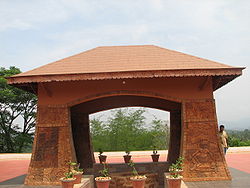 Pazhassi kudeeram: Tomb
of Pazhassi Raja
(who fought the British
to his death).
Valliyoorkkavu
(3 km from the town): This Temple is dedicated to Mother Goddess and is worshipped in three principal forms of Vana Durga
, Bhadrakali
and Jala Durga
It is the most important place of worship for the tribal communities. The annual 15 day festival is in March/April and is the most grand of all festivals in the district. Slave trade used to take place here during the festival. It is still the largest congregation of all tribals of Wayanad.
 Thirunelli Temple
: This is a famous pilgrim centre 36 km from Mananthavady.
Mananthavady Park : It is situated on the banks of the Mananthavady puzha (1 km from the Panchayath Bus Stand). The park is also known for its bat
colony. The attempts by the authorities to get rid of the bats lead to protests by environmental activists.
Brahmasthana Temple & Mata Amritanandamayi Math (1.5 km from the Town).
Paalamandhapam Devi Temple & Malakkari Temple Koolivayal(12 km from Mananthavady, 6 km from Panamaram town)
Latin Church
: Situated at the heart of the town. It is a reminder of the towns colonial past.
Gandhi Park : It is a junction where political meetings are held.
Kuruvadweep
(17 km east of Mananthavady ): 950 acres (3.8 km²) protected river delta system.
Boys town (15 km north of Mananthavady): Herbal garden, nature care centre, sericulture unit, perma-culture centre etc., established by the Wayanad Social Service Society and Gene Park (the Indo-Danish project for promoting herbal gardening) are situated here.
Tholpetty Wild Life Sanctuary : It is 24 km on the way to Coorg.
Pallikkal Juma Masjid (Kalyanathum Pallikkal): One of the oldest mosques in kerala situated in the heart of pallikkal angadi.
Periya
: About 25 km from Mananthavady town on Thalasserry road.
Chandanathode: The only pine forest in Wayand.
roads are used for reaching Mananthavadi from coastal towns & lower hilly towns of Kerala :
1. From Thalassery
: Nedumpoil
-Periya Ghat road, which connects Kasargod, Kannur
, Thalassery
& Kuthuparamba
with Wayanad
2. From Kozhikkode: Thamarassery
-Lakkidi Ghat road, part of NH 212, which connects Kozhikkode and the rest of Kerala, south of Kozhikkode with Wayanad
3. From Vadakara : Kuttiady
-Pakramthalam Ghat road, which connects Thalassery
, Vadakara
, Nadapuram
, Kuttiady
and Thottilpalam
with Wayanad
4. From Iritty
: Kottiyoor
-Ambayathode-Palchuram-Boys Town Ghat road, which connects lower hilly towns and villages of Kannur
and Kasargod districts with Wayanad. The towns are : Panathur, Udayagiri
, Cherupuzha
, Alakode
, Sreekandapuram
, Payyavoor
, Iritty
, Peravoor
, Kelakam
, Kottiyoor
, etc.
5. From Nilambur
: Vazhikkadavu
-Nadukani Ghat road, which connects Nilambur
, Palakkad
, Thrissur
and Perinthalmanna, with Wayanad.
Town
A town is a human settlement larger than a village but smaller than a city. The size a settlement must be in order to be called a "town" varies considerably in different parts of the world, so that, for example, many American "small towns" seem to British people to be no more than villages, while...
on the banks of Mananthavady Puzha a tributary of the Kabini River
Kabini River
The Kabini, also called Kabani and Kapila, is a river of southern India. It originates in Wayanad District of Kerala state, south India from the confluence of the Panamaram River and Mananthavady River, and flows eastward to join the Kaveri River at Tirumakudalu Narasipura in Karnataka, which...
in the Wayanad district
Wayanad District
Wayanad District in the north-east of Kerala, India, was formed on November 1, 1980 as the 12th district by carving out areas from Kozhikode and Kannur districts. Kalpetta is the district headquarters as well as the only municipal town in the district. The region was known as Mayakshetra in the...
of Kerala
Kerala
or Keralam is an Indian state located on the Malabar coast of south-west India. It was created on 1 November 1956 by the States Reorganisation Act by combining various Malayalam speaking regions....
, India
India
India , officially the Republic of India , is a country in South Asia. It is the seventh-largest country by geographical area, the second-most populous country with over 1.2 billion people, and the most populous democracy in the world...
.
This area was once ruled by the Pazhassi dynasty and the tomb of Pazhassi Raja
Pazhassi Raja
Kerala Varma Pazhassi Raja , popularly known as Kerala Simham or Lion of Kerala, was the Hindu Nair King of Kottayam , which was based in modern Kannur District, North Malabar zone of Kerala State in...
is an important heritage site located in the heart of the town. This is also the headquarters of the Adivasi Gothra Mahasabha. The Adivasi Autonomous Council, which led to tribal rights movement under C. K. Janu
C. K. Janu
C. K. Janu is the leader of the Adivasi Gothra Maha Sabha, a social movement that has been pushing for land to be redistributed to landless adivasis and that grew out of the Dalit-Adivasi Action Council in Kerala state, South India....
, was formed in a small hamlet called Panavalli near Mananthavady. The District Hospital in Mananthavady is the only major treatment facility for the service of the tribal communities and other less privileged sections of Wayanad. It is the third biggest town in Wayanad District
Wayanad District
Wayanad District in the north-east of Kerala, India, was formed on November 1, 1980 as the 12th district by carving out areas from Kozhikode and Kannur districts. Kalpetta is the district headquarters as well as the only municipal town in the district. The region was known as Mayakshetra in the...
, after Sulthan Bathery
Sulthan Bathery
Sultan Bathery - is a mid-sized town in Wayanad district of Kerala, India. It derives its present name from Tipu Sultan of Mysore who used the abandoned Jain temple here and used it as his battery here in the 18th century, hence the name Sultan's Battery. This town was part of Kidanganadu...
and Kalpetta
Kalpetta
Kalpetta is a city and a municipality in Wayanad district in the Indian state of Kerala. It is a small town surrounded by dense coffee plantations and mountains, is the headquarters of Wayanad district...
. Mananthavadi is located 35 km north-east of the district headquartes Kalpetta
Kalpetta
Kalpetta is a city and a municipality in Wayanad district in the Indian state of Kerala. It is a small town surrounded by dense coffee plantations and mountains, is the headquarters of Wayanad district...
, 80km east of Thalassery
Thalassery
Thalassery , also known as Tellicherry, is a city on the Malabar Coast of Kerala, India. This is the second largest city of North Malabar in terms of population. The name Tellicherry is the anglicized form of Thalassery. Thalassery municipality has a population just less than 100,000. Established...
and 110km north-east of Kozhikkode. Thalassery
Thalassery
Thalassery , also known as Tellicherry, is a city on the Malabar Coast of Kerala, India. This is the second largest city of North Malabar in terms of population. The name Tellicherry is the anglicized form of Thalassery. Thalassery municipality has a population just less than 100,000. Established...
-Bavali Road is the major road passing through Mananthavadi, which is well connected with both Mysore and Kodagu
Kodagu
Kodagu , also known by its anglicised former name of Coorg, is an administrative district in Karnataka, India. It occupies an area of in the Western Ghats of southwestern Karnataka. As of 2001, the population was 548,561, 13.74% of which resided in the district's urban centres, making it the least...
. Mananthavady is well connected with Mysore(110km away), via Kartikulam, Bavali and H D Kote, through Nagarhole National Park
Nagarhole National Park
Nagarhole National Park , also known as "Rajiv Gandhi National Park", is located from Mysore in Karnataka in South India. It is spread between Kodagu district and Mysore district. Located to the north-west of Bandipur National Park, Kabini reservoir separates the two. The park has rich forest...
. This road is parallel to Kabini River
Kabini River
The Kabini, also called Kabani and Kapila, is a river of southern India. It originates in Wayanad District of Kerala state, south India from the confluence of the Panamaram River and Mananthavady River, and flows eastward to join the Kaveri River at Tirumakudalu Narasipura in Karnataka, which...
and closed during the night time to protect wild animals. Another road goes to Gonikoppal
Gonikoppal
Gonikoppal is a census town in the Kodagu district of the Indian state of Karnataka.-Demographics: India census, Gonikoppal had a population of 7251. Males constitute 52% of the population and females 48%. Gonikoppal has an average literacy rate of 78%, higher than the national average of 59.5%:...
(60km away) in Kodagu
Kodagu
Kodagu , also known by its anglicised former name of Coorg, is an administrative district in Karnataka, India. It occupies an area of in the Western Ghats of southwestern Karnataka. As of 2001, the population was 548,561, 13.74% of which resided in the district's urban centres, making it the least...
, via Kartikulam, Tholpetty forest, Kutta and Ponnampet.
Places of interest
Tomb
A tomb is a repository for the remains of the dead. It is generally any structurally enclosed interment space or burial chamber, of varying sizes...
of Pazhassi Raja
Pazhassi Raja
Kerala Varma Pazhassi Raja , popularly known as Kerala Simham or Lion of Kerala, was the Hindu Nair King of Kottayam , which was based in modern Kannur District, North Malabar zone of Kerala State in...
(who fought the British
United Kingdom
The United Kingdom of Great Britain and Northern IrelandIn the United Kingdom and Dependencies, other languages have been officially recognised as legitimate autochthonous languages under the European Charter for Regional or Minority Languages...
to his death).
Valliyoorkkavu
Valliyoorkkavu
Valliyoorkkavu is an ancient temple located high in the Hills at Valliyoorkkavu, 3 kilometers from Mananthavady town of Wayanad district in Kerala. The temple is dedicated to goddess Bhagavathy or Durga....
(3 km from the town): This Temple is dedicated to Mother Goddess and is worshipped in three principal forms of Vana Durga
Durga
For the 1985 Hindi Film of Rajesh Khanna see DurgaaIn Hinduism, Durga ; ; meaning "the inaccessible" or "the invincible"; , durga) or Maa Durga "one who can redeem in situations of utmost distress" is a form of Devi, the supremely radiant goddess, depicted as having eighteen arms, riding a lion...
, Bhadrakali
Bhadrakali
Bhadrakāli , is one of the forms of the Great Goddess mentioned in the Devi Mahatmyam. In Sanskrit, the word Bhadra means "blessed", "auspicious", "fair", "beautiful", "good", "fortunate", "prosperous"....
and Jala Durga
Durga
For the 1985 Hindi Film of Rajesh Khanna see DurgaaIn Hinduism, Durga ; ; meaning "the inaccessible" or "the invincible"; , durga) or Maa Durga "one who can redeem in situations of utmost distress" is a form of Devi, the supremely radiant goddess, depicted as having eighteen arms, riding a lion...
It is the most important place of worship for the tribal communities. The annual 15 day festival is in March/April and is the most grand of all festivals in the district. Slave trade used to take place here during the festival. It is still the largest congregation of all tribals of Wayanad.
Thirunelli Temple
- Overview :Thirunelli Temple is an ancient temple dedicated to Lord Vishnu on the side of Brahmagiri hill in Kerala. The Temple is located at an altitude of about 900m in north Wayanad in a valley surrounded by mountains and beautiful forests...
: This is a famous pilgrim centre 36 km from Mananthavady.
Mananthavady Park : It is situated on the banks of the Mananthavady puzha (1 km from the Panchayath Bus Stand). The park is also known for its bat
Bat
Bats are mammals of the order Chiroptera "hand" and pteron "wing") whose forelimbs form webbed wings, making them the only mammals naturally capable of true and sustained flight. By contrast, other mammals said to fly, such as flying squirrels, gliding possums, and colugos, glide rather than fly,...
colony. The attempts by the authorities to get rid of the bats lead to protests by environmental activists.
Brahmasthana Temple & Mata Amritanandamayi Math (1.5 km from the Town).
Paalamandhapam Devi Temple & Malakkari Temple Koolivayal(12 km from Mananthavady, 6 km from Panamaram town)
Latin Church
Latin Church
The Latin Church is the largest particular church within the Catholic Church. It is a particular church not on the level of the local particular churches known as dioceses or eparchies, but on the level of autonomous ritual churches, of which there are 23, the remaining 22 of which are Eastern...
: Situated at the heart of the town. It is a reminder of the towns colonial past.
Gandhi Park : It is a junction where political meetings are held.
Kuruvadweep
Kuruvadweep
Kuruvadweep is a protected river delta on the Kabini River in the Wayanad district, Kerala, India.This island of dense and evergreen forest is uninhabited and hence a home to rare kinds of flora and fauna: uncommon species of birds, orchids and herbs namely...
(17 km east of Mananthavady ): 950 acres (3.8 km²) protected river delta system.
Boys town (15 km north of Mananthavady): Herbal garden, nature care centre, sericulture unit, perma-culture centre etc., established by the Wayanad Social Service Society and Gene Park (the Indo-Danish project for promoting herbal gardening) are situated here.
Tholpetty Wild Life Sanctuary : It is 24 km on the way to Coorg.
Pallikkal Juma Masjid (Kalyanathum Pallikkal): One of the oldest mosques in kerala situated in the heart of pallikkal angadi.
Periya
Periya
-Demographics: India census, Periya had a population of 12659 with 6184 males and 6475 females....
: About 25 km from Mananthavady town on Thalasserry road.
Chandanathode: The only pine forest in Wayand.
Public Libraries
Pazhassi Smaraka Granthalayam, Solidarity Library, Anjukunnu Pothujana GrandhalayamVillages
- VellamundaVellamundaVellamunda is a village and a Gram panchayat in the Wayanad district of Kerala, India. Situated at the foot of Banasura Peak and Mangalassery hill Vellamunda has rich greenery and scenic beauty to flaunt off. Famous tourist attraction is Banasura Sagar earth dam, which is the largest of its kind...
- Peruvaka
- Ambukuthy
- NalloornadNalloornad-Demographics: India census, Nalloornad had a population of 15548 with 7920 males and 7628 females....
- Cherukattoor
- PayyampallyPayyampallyPayyampally is a village in Wayanad district in the state of Kerala, India.-Demographics: India census, Payyampally had a population of 12391 with 6276 males and 6115 females....
- Koilery
- Puthiyidam
- Aarattuthara
- Thavinjal
- ozhakkody
- VimalanagerVimalanagerVimala Nagar is a village in Mananthavady taluk, Wayanad district, Kerala, India.Vimala Nagar is a small place in Thavinjal grama panchayat in the Mananthavady thaluk.It is mainly an agrarian sector....
- Thalapuzha
- AnjukunnuAnchukunnu- ANJUKUNNU : Anjukunnu is a village in Wayanad district in the state of Kerala, India.-Demographics: India census, Anjukunnu had a population of 18049 with 9167 males and 8882 females.Anjukunnu means five hills in Malayalam language...
- PanamaramPanamaram-Demographics: India census, Panamaram had a population of 11651 with 5891 males and 5760 females.-Panamaram River:Panamaram River is a tributary of the Kabani River along with Mananthavady, Babali, Noolpuzha and Nugu Rivers. Kabani and its tributaries play a key role in the enhancement of the...
- TharuvanaTharuvanaTharuvana is a small town in Vellamunda Panchayath of Wayanad district, Kerala, India. The place is a junction en route to Mananthavady. The word "tharuvana" is derived from malayalam words "tharu" and "ana" . The combined word "Tharuvana" means Please give Cash. Earlier this place was a tax...
- Ellumannam
- KallodyKallodyKallody is a village in Edavaka Panchayath of Wayanad district, Kerala, India. This village falls under Mananthavady Taluk. The word Kallody is derived from malayalam words kallu and ody . The combined word Kallody means running stone.Earlier this place was a forested area...
- OorpallyOorpallyOorpally is a small village on the banks of the river Kabini in the Wayanad district of Kerala state, south India.Agriculture is the main stay of the economy. Coffee, black pepper and vanilla are the main cash crops.-River: Kabni River...
- ValatValatValat is a village in Wayanad district in the state of Kerala, India.It is the village situated near to kannur district.Govt.HSS is the only Higher Secondary school in the village.Most of people are in the field of agriculture...
- Trissilery
Ghat Roads
Mainly 5 GhatGhat
Ghat is the capital of the Ghat District in the Fezzan region of southwestern Libya.-History:In historical times, Ghat was a major terminal point on the Trans-Saharan trade route and a major administrative center in the Fezzan...
roads are used for reaching Mananthavadi from coastal towns & lower hilly towns of Kerala :
1. From Thalassery
Thalassery
Thalassery , also known as Tellicherry, is a city on the Malabar Coast of Kerala, India. This is the second largest city of North Malabar in terms of population. The name Tellicherry is the anglicized form of Thalassery. Thalassery municipality has a population just less than 100,000. Established...
: Nedumpoil
Nedumpoil
Nedumpoil is a small village in the Kannur district of Kerala, South India. It is situated between two major towns, Thalassery and Mananthavady.Nedumpoil sits at the junction of roads from Thalassery , Kottiyoor and Manathavady...
-Periya Ghat road, which connects Kasargod, Kannur
Kannur
Kannur , also known as Cannanore, is a city in Kannur district in the Indian state of Kerala. It is the administrative headquarters of the District of Kannur and 518km north of state capital Trivandrum. During British rule in India, Kannur was known by its old name Cannanore, which is still in...
, Thalassery
Thalassery
Thalassery , also known as Tellicherry, is a city on the Malabar Coast of Kerala, India. This is the second largest city of North Malabar in terms of population. The name Tellicherry is the anglicized form of Thalassery. Thalassery municipality has a population just less than 100,000. Established...
& Kuthuparamba
Kuthuparamba
Kuthuparamba is a town and a municipality in Kannur district in the Kerala state of the country India.-Geography:Kuttuparamba has an average elevation of ....
with Wayanad
2. From Kozhikkode: Thamarassery
Thamarassery
Thamarassery is a picturesque town in Kozhikode district of Kerala, India, 30 km east of Kozhikode City. It lies on the Calicut - Wayanad route...
-Lakkidi Ghat road, part of NH 212, which connects Kozhikkode and the rest of Kerala, south of Kozhikkode with Wayanad
3. From Vadakara : Kuttiady
Kuttiady
Kuttiyady is a small town in the northern part of Kozhikode district in Kerala state, India. Twenty nine km from Vadakara, Kuttiadi acknowledged the supremacy of the Kottayam Raja, whose fortified palace stands on a hill. During the Pazhassi rebellion, Kuttiadi, which commanded one of the chief...
-Pakramthalam Ghat road, which connects Thalassery
Thalassery
Thalassery , also known as Tellicherry, is a city on the Malabar Coast of Kerala, India. This is the second largest city of North Malabar in terms of population. The name Tellicherry is the anglicized form of Thalassery. Thalassery municipality has a population just less than 100,000. Established...
, Vadakara
Vatakara
Vatakara is a coastal Municipality in Kozhikode district of Kerala, a South Indian state, spread over an area of 23.33 km2. It is the headquarters of Vatakara taluk. This place is erstwhile Kadathanadu and was part of North Malabar province of Malabar District in Madras State during British...
, Nadapuram
Nadapuram
Nadapuram is a special grade Panchayath, coming under Nadapuram assembly constituency. It is in North Malabar region of Kerala, India. Four times Nadapuram won the best panchayat award of Kozhikode district....
, Kuttiady
Kuttiady
Kuttiyady is a small town in the northern part of Kozhikode district in Kerala state, India. Twenty nine km from Vadakara, Kuttiadi acknowledged the supremacy of the Kottayam Raja, whose fortified palace stands on a hill. During the Pazhassi rebellion, Kuttiadi, which commanded one of the chief...
and Thottilpalam
Thottilpalam
Thottilpalam is a town in north east of Kozhikode district, Kerala. It is under Nadapuram assembly constituency. A KSRTC Sub Depot is operating here. Major bus service from here are to Kozhikode, Mananthavadi and Vadakara....
with Wayanad
4. From Iritty
Iritty
Iritty is a small town in the district of Kannur in the state of Kerala, India. It comes in Keezhur-Chavassery Panchayath. The town is the main market place for the farmer communities in the surrounding regions.-Location:...
: Kottiyoor
Kottiyoor
A very ancient Siva Temple situated here attracts lakhs of devotees every year. The Bavali river, Paalukaachi hill, all are tourists places in Kottiyoor....
-Ambayathode-Palchuram-Boys Town Ghat road, which connects lower hilly towns and villages of Kannur
Kannur district
Kannur District is one of the 14 districts in the state of Kerala, India. The town of Kannur is the district headquarters, and gives the district its name. The old name Cannanore is the anglicised form of the Malayalam name Kannur. Kannur District is bounded by Kasaragod District to the north and...
and Kasargod districts with Wayanad. The towns are : Panathur, Udayagiri
Udayagiri, Kannur
Udayagiri is a small beautiful village in Thaliparamba taluk of Kannur District in Kerala, south India. It is about 60 km from Kannur city. People of this village mainly depend on agriculture for their income...
, Cherupuzha
Cherupuzha (Kannur)
Cherupuzha is a panchayath, or traditional village, in the Payyannur area of Kannur district, India.Cherupuzha town, which is the headquarters of the panchayat, is a small town located about 30 kilometers east of Payyannur, in Kannur District of Kerala....
, Alakode
Alakode
Alakode is a village in Kannur district in the Indian state of Kerala.. Alakode was one of the major centres of Malabar Migration. People here are almost in equal ratio of Hindu, Muslims and Christians. Most people are engaged in agriculture and business.This area exports hill products viz...
, Sreekandapuram
Sreekandapuram
Sreekandapuram is a town and panchayat in Kannur district, in the Indian state of Kerala.-Administration:Sreekandapuram was historically ruled by the Mushika Kingdom....
, Payyavoor
Payyavoor
Payyavoor is a village in Kannur district in the Indian state of Kerala.The Festival in the Temple of Lord Siva here is very famous which is celebrated from 1 to 12 Kumbham . There is a Knanaya Catholic Church in the town named St.Anne's Church.There are some establishments like Panchayat Office,...
, Iritty
Iritty
Iritty is a small town in the district of Kannur in the state of Kerala, India. It comes in Keezhur-Chavassery Panchayath. The town is the main market place for the farmer communities in the surrounding regions.-Location:...
, Peravoor
Peravoor
Peravoor is a small town in Kannur district of Kerala state, south India.Peravoor is a panchayt. This is a small town located in Kannur district. It south of Kannur and Thalaserry. Same distance from each railway station. The nearest town with hotels is Iritty. Iritty is forty kilometers from...
, Kelakam
Kelakam
Kelakam is a town in the Kannur district of Kerala. The Bavali River runs through the town, and the Kottiyoor Sivva temple is seven kilometres away....
, Kottiyoor
Kottiyoor
A very ancient Siva Temple situated here attracts lakhs of devotees every year. The Bavali river, Paalukaachi hill, all are tourists places in Kottiyoor....
, etc.
5. From Nilambur
Nilambur
Nilambur is a municipality and a taluk in the Malappuram district of Kerala, South India. It is famous for its forests, especially its wildlife habitats, rivers, waterfalls and teak plantations. It is situated close to the Nilgiris range of the Western Ghats on the banks of the Chaliyar River...
: Vazhikkadavu
Vazhikkadavu
Vazhikkadavu is a small town in Nilambur taluk of Malappuram district, India. It is located on the CNG road 20 km north-east of Nilambur town. Just after Vazhikkadavu town the ghat road starts through forests leading to Nadukani in Nilgiris district...
-Nadukani Ghat road, which connects Nilambur
Nilambur
Nilambur is a municipality and a taluk in the Malappuram district of Kerala, South India. It is famous for its forests, especially its wildlife habitats, rivers, waterfalls and teak plantations. It is situated close to the Nilgiris range of the Western Ghats on the banks of the Chaliyar River...
, Palakkad
Palakkad
Palakkad , formerly known as Palghat, is a municipality and a town in the state of Kerala in southern India, spread over an area of 26.60 km2.The city is situated about north of state capital Thiruvananthapuram. It is the administrative headquarters of Palakkad District...
, Thrissur
Thrissur
This article is about the city in India. For the district, see Thrissur district. For the urban agglomeration area of Thrissur see Thrissur Metropolitan Area...
and Perinthalmanna, with Wayanad.
Getting there
- Rail- Nearest railway station is at ThalasseryThalasseryThalassery , also known as Tellicherry, is a city on the Malabar Coast of Kerala, India. This is the second largest city of North Malabar in terms of population. The name Tellicherry is the anglicized form of Thalassery. Thalassery municipality has a population just less than 100,000. Established...
, 80km away . - Road- ThalasseryThalasseryThalassery , also known as Tellicherry, is a city on the Malabar Coast of Kerala, India. This is the second largest city of North Malabar in terms of population. The name Tellicherry is the anglicized form of Thalassery. Thalassery municipality has a population just less than 100,000. Established...
-80km, KozhikodeKozhikodeKozhikode During Classical antiquity and the Middle Ages, Kozhikkode was dubbed the "City of Spices" for its role as the major trading point of eastern spices. Kozhikode was once the capital of an independent kingdom of the same name and later of the erstwhile Malabar District...
-110km, Mysore-110km. Frequent buses are available to ThalasseryThalasseryThalassery , also known as Tellicherry, is a city on the Malabar Coast of Kerala, India. This is the second largest city of North Malabar in terms of population. The name Tellicherry is the anglicized form of Thalassery. Thalassery municipality has a population just less than 100,000. Established...
, KozhikodeKozhikodeKozhikode During Classical antiquity and the Middle Ages, Kozhikkode was dubbed the "City of Spices" for its role as the major trading point of eastern spices. Kozhikode was once the capital of an independent kingdom of the same name and later of the erstwhile Malabar District...
, KodaguKodaguKodagu , also known by its anglicised former name of Coorg, is an administrative district in Karnataka, India. It occupies an area of in the Western Ghats of southwestern Karnataka. As of 2001, the population was 548,561, 13.74% of which resided in the district's urban centres, making it the least...
& Mysore - Air-Nearest airport is Kozhikode International Airport-136km. Kannur International AirportKannur International AirportKannur International Airport is an upcoming international airport located at Mattanur in Kannur District, Kerala, India. The airport is the fourth international airport in Kerala.As of 19 July 2011, has been acquired for the airport out of notified...
(under construction at Mattannur) is at a distance of 70km.