
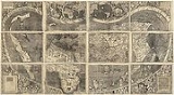
Waldseemüller map
Encyclopedia
Germany
Germany , officially the Federal Republic of Germany , is a federal parliamentary republic in Europe. The country consists of 16 states while the capital and largest city is Berlin. Germany covers an area of 357,021 km2 and has a largely temperate seasonal climate...
cartographer
Cartography
Cartography is the study and practice of making maps. Combining science, aesthetics, and technique, cartography builds on the premise that reality can be modeled in ways that communicate spatial information effectively.The fundamental problems of traditional cartography are to:*Set the map's...
Martin Waldseemüller
Martin Waldseemüller
Martin Waldseemüller was a German cartographer...
, originally published in April 1507. It is known as the first map to use the name "America
Americas
The Americas, or America , are lands in the Western hemisphere, also known as the New World. In English, the plural form the Americas is often used to refer to the landmasses of North America and South America with their associated islands and regions, while the singular form America is primarily...
". The map is drafted on a modification of Ptolemy's second projection, expanded to accommodate the Americas and the high latitudes. A single copy of the map survives, presently housed at the Library of Congress
Library of Congress
The Library of Congress is the research library of the United States Congress, de facto national library of the United States, and the oldest federal cultural institution in the United States. Located in three buildings in Washington, D.C., it is the largest library in the world by shelf space and...
in Washington, D.C. Waldseemüller also created globe gores
Gore (segment)
A gore is a segment of a three-dimensional shape fabricated from a two-dimensional material. The term was originally used to describe triangular shapes, but is now extended to any shape that can be used to create the third dimension.-Examples:...
, printed maps designed to be cut out and pasted onto spheres to form globes of the Earth.
Description
The wall map consists of twelve sections printed from wood engravings measuring 18 x 24.5 inches (46 x 62 cm). Each section is one of four horizontally and three vertically, when assembled. The map uses a modified Ptolemaic map projectionMap projection
A map projection is any method of representing the surface of a sphere or other three-dimensional body on a plane. Map projections are necessary for creating maps. All map projections distort the surface in some fashion...
with curved meridians to depict the entire surface of the Earth.
The full title of the map is Universalis cosmographia secundum Ptholomaei traditionem et Americi Vespucii aliorumque lustrationes (The Universal Cosmography according to the Tradition of Ptolemy and the Discoveries of Amerigo Vespucci and others). One of the "others" was Christopher Columbus
Christopher Columbus
Christopher Columbus was an explorer, colonizer, and navigator, born in the Republic of Genoa, in northwestern Italy. Under the auspices of the Catholic Monarchs of Spain, he completed four voyages across the Atlantic Ocean that led to general European awareness of the American continents in the...
. Several earlier maps are believed to be sources, chiefly those based on the Geography (Ptolemy) and the Caveri planisphere
Planisphere
A planisphere is a star chart analog computing instrument in the form of two adjustable disks that rotate on a common pivot. It can be adjusted to display the visible stars for any time and date. It is an instrument to assist in learning how to recognize stars and constellations...
and others similar to those of Henricus Martellus or Martin Behaim
Martin Behaim
Martin Behaim , was a German mariner, artist, cosmographer, astronomer, philosopher, geographer and explorer in service to the King of Portugal.-Biography:The Behaim family had immigrated to Nuremberg because of religious persecution around...
. The Caribbean
Caribbean
The Caribbean is a crescent-shaped group of islands more than 2,000 miles long separating the Gulf of Mexico and the Caribbean Sea, to the west and south, from the Atlantic Ocean, to the east and north...
and what appears to be Florida
Florida
Florida is a state in the southeastern United States, located on the nation's Atlantic and Gulf coasts. It is bordered to the west by the Gulf of Mexico, to the north by Alabama and Georgia and to the east by the Atlantic Ocean. With a population of 18,801,310 as measured by the 2010 census, it...
were depicted on two earlier charts, the Cantino map
Cantino planisphere
The Cantino planisphere is the earliest surviving map showing Portuguese Discoveries in the east and west. It is named after Alberto Cantino, an agent for the Duke of Ferrara, who successfully smuggled it from Portugal to Italy in 1502...
, smuggled from Portugal to Italy in 1502 showing details known in 1500, and the Caverio map
Caverio map
The Caverio Map is a map drawn by Nicolay de Caveri, circa 1505.-History:Currently at Bibliothèque Nationale de France in Paris. First described in 1890 and reproduced two years later. This undated map was one of the primary sources used to make the Waldseemüller map in 1507...
, drawn circa 1503-1504 and showing the Gulf of Mexico
Gulf of Mexico
The Gulf of Mexico is a partially landlocked ocean basin largely surrounded by the North American continent and the island of Cuba. It is bounded on the northeast, north and northwest by the Gulf Coast of the United States, on the southwest and south by Mexico, and on the southeast by Cuba. In...
.
While some maps after 1500 show, with ambiguity, an eastern coastline for Asia
Asia
Asia is the world's largest and most populous continent, located primarily in the eastern and northern hemispheres. It covers 8.7% of the Earth's total surface area and with approximately 3.879 billion people, it hosts 60% of the world's current human population...
distinct from the Americas
Americas
The Americas, or America , are lands in the Western hemisphere, also known as the New World. In English, the plural form the Americas is often used to refer to the landmasses of North America and South America with their associated islands and regions, while the singular form America is primarily...
, the Waldseemüller map apparently indicates the existence of a new ocean between the trans-Atlantic regions of the Spanish discoveries and the Asia of Ptolemy and Marco Polo as exhibited on the 1492 Behaim globe. The first historical records of Europeans to set eyes on this ocean, the Pacific
Pacific Ocean
The Pacific Ocean is the largest of the Earth's oceanic divisions. It extends from the Arctic in the north to the Southern Ocean in the south, bounded by Asia and Australia in the west, and the Americas in the east.At 165.2 million square kilometres in area, this largest division of the World...
, are recorded as Vasco Núñez de Balboa
Vasco Núñez de Balboa
Vasco Núñez de Balboa was a Spanish explorer, governor, and conquistador. He is best known for having crossed the Isthmus of Panama to the Pacific Ocean in 1513, becoming the first European to lead an expedition to have seen or reached the Pacific from the New World.He traveled to the New World in...
in 1513 or, Ponce de León
Juan Ponce de León
Juan Ponce de León was a Spanish explorer. He became the first Governor of Puerto Rico by appointment of the Spanish crown. He led the first European expedition to Florida, which he named...
in 1512 or 1513. Those dates are five to six years after Waldseemüller made his map. In addition, the map apparently predicts the width of South America at certain latitudes to within 70 miles. However, as pointed out by E.G. Ravenstein, this is an illusory effect of the cordiform projection used by Waldseemüller, for when the map is laid out on a more familiar quadratic projection and compared with others of the period also set out on that same projection there is little difference between them: this is particularly evident when the comparison is made with Johannes Schöner
Johannes Schöner
Johannes Schöner was a renowned and respected German polymath...
's 1515 globe.
Apparently among most map-makers until that time, it was still erroneously believed that the lands discovered by Christopher Columbus
Christopher Columbus
Christopher Columbus was an explorer, colonizer, and navigator, born in the Republic of Genoa, in northwestern Italy. Under the auspices of the Catholic Monarchs of Spain, he completed four voyages across the Atlantic Ocean that led to general European awareness of the American continents in the...
, Vespucci, and others formed part of the Indies
Indies
The Indies is a term that has been used to describe the lands of South and Southeast Asia, occupying all of the present India, Pakistan, Bangladesh, Myanmar, Nepal, Sri Lanka, the Maldives, and also Thailand, Cambodia, Laos, Vietnam, Brunei, Singapore, the Philippines, East Timor, Malaysia and...
of Asia. Thus some believe that it is impossible that Waldseemüller could have known about the Pacific, which is depicted on his map. The historian Peter Whitfield has theorized that Waldseemüller incorporated the ocean into his map because Vespucci's accounts of the Americas, with their so-called "savage" peoples, could not be reconciled with contemporary knowledge of India
India
India , officially the Republic of India , is a country in South Asia. It is the seventh-largest country by geographical area, the second-most populous country with over 1.2 billion people, and the most populous democracy in the world...
, China
China
Chinese civilization may refer to:* China for more general discussion of the country.* Chinese culture* Greater China, the transnational community of ethnic Chinese.* History of China* Sinosphere, the area historically affected by Chinese culture...
, and the islands of Indies. Thus, in the view of Whitfield, Waldseemüller reasoned that the newly discovered lands could not be part of Asia, but must be separate from it, a leap of intuition that was later proved uncannily precise.An alternative explanation is that of George E. Nunn (see below).
Mundus Novus, a book attributed to Vespucci (who had himself explored the extensive eastern coast of South America) was widely published throughout Europe after 1504, including by Waldseemüller's group in 1507. It had first introduced to Europeans the idea that this was a new continent and not Asia. It is theorized that this led to Waldseemüller's separating the Americas from Asia, depicting the Pacific Ocean, and the use of the first name of Vespucci on his map.
Waldseemüller said in Chapter IX of the Cosmographiae Introductio, an explanatory text written to accompany the map, that the earth was now known to be divided into four parts, of which Europe, Asia and Africa, being contiguous with each other, were continents, while the fourth part, America, was “an island, inasmuch as it is found to be surrounded on all sides by the seas”.
The inscription on the top left corner of the map proclaims that the discovery of America by Columbus and Vespucci fulfilled a prophecy of the Roman poet, Virgil
Virgil
Publius Vergilius Maro, usually called Virgil or Vergil in English , was an ancient Roman poet of the Augustan period. He is known for three major works of Latin literature, the Eclogues , the Georgics, and the epic Aeneid...
, made in the Aeneid
Aeneid
The Aeneid is a Latin epic poem, written by Virgil between 29 and 19 BC, that tells the legendary story of Aeneas, a Trojan who travelled to Italy, where he became the ancestor of the Romans. It is composed of roughly 10,000 lines in dactylic hexameter...
(VI. 795–7), of a land to be found in the southern hemisphere, to the south of the Tropic of Capricorn:
Many have thought to be an invention what the famous Poet said, that “a land lies beyond the stars, beyond the paths of the year and the sun, where Atlas the heaven-bearer turns on his shoulder the axis of the world set with blazing stars”; but now, at last, it proves clearly to have been true. It is, in fact, the land discovered by the King of Castile’s captain, Columbus, and by Americo Vesputius, men of great and excellent talent, of which the greater part lies under the path of the year and sun, and between the tropics but extending nonetheless to about nineteen degrees beyond Capricorn toward the Antarctic pole beyond the paths of the year and the sun. Wherein, indeed, a greater amount of gold is to be found than of any other metal.
The “path” referred to is the ecliptic, which marks the sun's yearly movement along the constellations of the zodiac, so that to go beyond it meant crossing the southernmost extent of the ecliptic, the Tropic of Capricorn. Nineteen degrees beyond Capricorn is Latitude forty-two degrees South, the southernmost extent of America shown on Waldseemüller’s map. The map legend shows how Waldseemüller strove to reconcile the new geographic information with the knowledge inherited from antiquity.
The Waldseemüller main map, and his globe gores of the same date, depict the American continents in two pieces. These depictions differ from the small inset map in the top border, which shows the two American continents joined by an isthmus
Isthmus
An isthmus is a narrow strip of land connecting two larger land areas usually with waterforms on either side.Canals are often built through isthmuses where they may be particularly advantageous to create a shortcut for marine transportation...
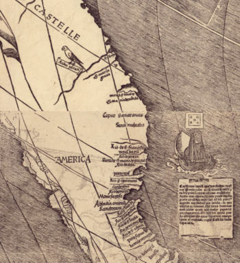
. The name America is placed on what is now called South America
South America
South America is a continent situated in the Western Hemisphere, mostly in the Southern Hemisphere, with a relatively small portion in the Northern Hemisphere. The continent is also considered a subcontinent of the Americas. It is bordered on the west by the Pacific Ocean and on the north and east...
on the main map, this being the first map known to use this name. As explained in Cosmographiae Introductio
Cosmographiae Introductio
Cosmographiae Introductio was a book published in 1507 to accompany Martin Waldseemüller's printed globe and wall-map , which were the first appearance of the name 'America'...
, the name was bestowed in honor of Amerigo Vespucci
Amerigo Vespucci
Amerigo Vespucci was an Italian explorer, financier, navigator and cartographer. The Americas are generally believed to have derived their name from the feminized Latin version of his first name.-Expeditions:...
. The most southerly feature named on the coast of America on the Waldseemüller map is Rio decananorum, the “River of the Cananoreans”. This was taken from Vespucci, who in 1501 during his voyage along this coast reached the port which he called Cananor (now Cananéia
Cananéia
Cananéia is the southernmost city in the state of São Paulo, Brazil, near to where the Tordesilhas Line passed. The population in 2008 was 12,377 and the area is 1,242.010 km². The elevation is 8 m. The city of Cananéia is host to the Dr. João de Paiva Carvalho research base belonging to the...
). Cananor was the port of Kannur
Kannur
Kannur , also known as Cannanore, is a city in Kannur district in the Indian state of Kerala. It is the administrative headquarters of the District of Kannur and 518km north of state capital Trivandrum. During British rule in India, Kannur was known by its old name Cannanore, which is still in...
in southern India, the farthest port reached in India during the 1500-1501 voyage of the Portuguese Pedro Álvares Cabral
Pedro Álvares Cabral
Pedro Álvares Cabral was a Portuguese noble, military commander, navigator and explorer regarded as the discoverer of Brazil. Cabral conducted the first substantial exploration of the northeast coast of South America and claimed it for Portugal. While details of Cabral's early life are sketchy, it...
, the discoverer of Brazil, two of whose ships were encountered returning from India by Vespucci. This may be an indication Waldseemüller thought that the “River of the Cananoreans” could have actually been in the territory of Cananor in India and that America was, therefore, part of India.
The name for the northern land mass, Parias, is derived from a passage in the Four Voyages of Amerigo Vespucci, in which, after several stops, the expedition arrives at a region that was “situated in the torrid zone directly under the parallel which describes the Tropic of Cancer. And this province is called by them [the inhabitants] Parias”. Parias was described by Waldseemüller’s follower, Johannes Schöner
Johannes Schöner
Johannes Schöner was a renowned and respected German polymath...
as: “The island of Parias, which is not a part or portion of the foregoing [America] but a large, special part of the fourth part of the world”, indicating uncertainty as to its situation.
The map shows the cities of catigara (Kattigara) and Mallaqua (Malacca
Malacca
Malacca , dubbed The Historic State or Negeri Bersejarah among locals) is the third smallest Malaysian state, after Perlis and Penang. It is located in the southern region of the Malay Peninsula, on the Straits of Malacca. It borders Negeri Sembilan to the north and the state of Johor to the south...
) on the western coast of the great peninsula that projects from the southeastern part of Asia, or INDIA MERIDIONALIS (Southern India) as Waldseemüller called it. This peninsula forms the eastern side of the SINUS MAGNUS, or Great Gulf, the actual Gulf of Thailand
Gulf of Thailand
The Gulf of Thailand , also known in to Malays as Teluk Siam literally meant Gulf of Siam, is a shallow arm of the South China Sea.-Geography:...
. Amerigo Vespucci, writing of his 1499 voyage, said he had hoped to sail westward from Spain across the Western Ocean (the Atlantic) around the Cape of Cattigara mentioned by Ptolemy into the Sinus Magnus. Ptolemy understood Cattigara, or Kattigara, to be the most eastern port reached by shipping trading from the Graeco-Roman world to the lands of the Far East. Vespucci failed to find the Cape of Cattigara on his 1499 voyage: he sailed along the coast of Venezuela but not far enough to resolve the question of whether there was a sea passage beyond leading to Ptolemy’s Sinus Magnus. The object of his voyage of 1503-1504 was to reach the fabulous spice emporium of “Melaccha in India” (that is, Malacca, or Melaka, on the Malay Peninsula). He had learned of Malacca from one Guaspare (or Gaspard), a pilot with Pedro Alvares Cabral
Pedro Álvares Cabral
Pedro Álvares Cabral was a Portuguese noble, military commander, navigator and explorer regarded as the discoverer of Brazil. Cabral conducted the first substantial exploration of the northeast coast of South America and claimed it for Portugal. While details of Cabral's early life are sketchy, it...
’s fleet on its voyage to India in 1500-1501, whom Vespucci had encountered in the Atlantic on his return from India in May 1501. Christopher Columbus, in his fourth and last voyage of 1502-1503, planned to follow the coast of Champa
Champa
The kingdom of Champa was an Indianized kingdom that controlled what is now southern and central Vietnam from approximately the 7th century through to 1832.The Cham people are remnants...
southward around the Cape of Cattigara and sail through the strait separating Cattigara from the New World, into the Sinus Magnus to Malacca. This was the route he understood Marco Polo
Marco Polo
Marco Polo was a Venetian merchant traveler from the Venetian Republic whose travels are recorded in Il Milione, a book which did much to introduce Europeans to Central Asia and China. He learned about trading whilst his father and uncle, Niccolò and Maffeo, travelled through Asia and apparently...
to have gone from China to India in 1292 (although Malacca had not yet been founded in Polo’s time). Columbus anticipated that he would meet up with the expedition sent at the same time from Portugal to Malacca around the Cape of Good Hope under Vasco da Gama
Vasco da Gama
Vasco da Gama, 1st Count of Vidigueira was a Portuguese explorer, one of the most successful in the Age of Discovery and the commander of the first ships to sail directly from Europe to India...
, and carried letters of credence from the Spanish monarchs to present to da Gama. The map therefore shows the two cities that were the initial destinations of Amerigo Vespucci and Christopher Columbus in their voyages that led to the unexpected discovery of a New World.
Just to the south of Mallaqua (Malacca
Malacca
Malacca , dubbed The Historic State or Negeri Bersejarah among locals) is the third smallest Malaysian state, after Perlis and Penang. It is located in the southern region of the Malay Peninsula, on the Straits of Malacca. It borders Negeri Sembilan to the north and the state of Johor to the south...
) is the inscription: hic occisus est S. thomas (Here St. Thomas was killed), referring to the legend that Saint Thomas the Apostle
Thomas the Apostle
Thomas the Apostle, also called Doubting Thomas or Didymus was one of the Twelve Apostles of Jesus. He is best known for questioning Jesus' resurrection when first told of it, then proclaiming "My Lord and my God" on seeing Jesus in . He was perhaps the only Apostle who went outside the Roman...
to India was killed and entombed there. Waldseemüller had confused Malacca (Melaka) with Mylapore
Mylapore
Mylapore is a cultural hub and neighborhood in the southern part of the city of Chennai, the capital of Tamil Nadu, India. Earlier, Mylapore used to be called Vedapuri....
in India. The contemporary understanding of the nature of Columbus’ discoveries is demonstrated in the letter written to him by the Aragonese cosmographer and Royal counsellor, Jaume Ferrer, dated 5 August 1495, saying: “Divine and infallible Providence sent the great Thomas from the Occident into the Orient in order to declare in India our Holy and Catholic Law; and you, Sir, it has sent to this opposite part of the Orient by way of the Ponient [West] so that by the Divine Will you might arrive in the Orient, and in the farthest parts of India Superior in order that the descendants might hear that which their ancestors neglected concerning the teaching of Thomas…and very soon you will be by the Divine Grace in the Sinus Magnus, near which the glorious Thomas left his sacred body”.
History
At the time this wall map was drawn, Waldseemüller was working as part of the group of scholars of the Vosgean Gymnasium at Saint-Dié-des-VosgesSaint-Dié-des-Vosges
Saint-Dié-des-Vosges, commonly referred to as Saint-Dié, is a commune in the Vosges department in Lorraine in northeastern France.It is a sub-prefecture of the department.-Geography:...
in Lorraine
Lorraine (province)
The Duchy of Upper Lorraine was an historical duchy roughly corresponding with the present-day northeastern Lorraine region of France, including parts of modern Luxembourg and Germany. The main cities were Metz, Verdun, and the historic capital Nancy....
, which in that time belonged to the Holy Roman Empire
Holy Roman Empire
The Holy Roman Empire was a realm that existed from 962 to 1806 in Central Europe.It was ruled by the Holy Roman Emperor. Its character changed during the Middle Ages and the Early Modern period, when the power of the emperor gradually weakened in favour of the princes...
. The maps were accompanied by the book Cosmographiae Introductio
Cosmographiae Introductio
Cosmographiae Introductio was a book published in 1507 to accompany Martin Waldseemüller's printed globe and wall-map , which were the first appearance of the name 'America'...
produced by the Vosgean Gymnasium.
Johannes Schöner
Johannes Schöner was a renowned and respected German polymath...
(1477–1547), a Nuremberg
Nuremberg
Nuremberg[p] is a city in the German state of Bavaria, in the administrative region of Middle Franconia. Situated on the Pegnitz river and the Rhine–Main–Danube Canal, it is located about north of Munich and is Franconia's largest city. The population is 505,664...
astronomer, geographer, and cartographer. Its existence was unknown for a long time until its rediscovery in 1901 in the library of Prince Johannes zu Waldburg-Wolfegg in Wolfegg
Wolfegg
Wolfegg is a town in the district of Ravensburg in Baden-Württemberg in Germany.-Overview:It is the site of Wolfegg Castle, the home of the Princes of Waldburg-Wolfegg, longtime owners of the only known copy of the Waldseemüller map. The map remained at the castle until 2001 when the...
Castle in Württemberg
Württemberg
Württemberg , formerly known as Wirtemberg or Wurtemberg, is an area and a former state in southwestern Germany, including parts of the regions Swabia and Franconia....
, Germany
Germany
Germany , officially the Federal Republic of Germany , is a federal parliamentary republic in Europe. The country consists of 16 states while the capital and largest city is Berlin. Germany covers an area of 357,021 km2 and has a largely temperate seasonal climate...
by the Jesuit historian Joseph Fischer. It remained there until 2001 when the United States
United States
The United States of America is a federal constitutional republic comprising fifty states and a federal district...
Library of Congress
Library of Congress
The Library of Congress is the research library of the United States Congress, de facto national library of the United States, and the oldest federal cultural institution in the United States. Located in three buildings in Washington, D.C., it is the largest library in the world by shelf space and...
purchased it from Waldburg-Wolfegg-Waldsee for ten million dollars. Chancellor Angela Merkel
Angela Merkel
Angela Dorothea Merkel is the current Chancellor of Germany . Merkel, elected to the Bundestag from Mecklenburg-Vorpommern, has been the chairwoman of the Christian Democratic Union since 2000, and chairwoman of the CDU-CSU parliamentary coalition from 2002 to 2005.From 2005 to 2009 she led a...
of the Federal Republic of Germany symbolically turned over the Waldseemüller map on April 30, 2007, within the context of a formal ceremony at the Library of Congress
Library of Congress
The Library of Congress is the research library of the United States Congress, de facto national library of the United States, and the oldest federal cultural institution in the United States. Located in three buildings in Washington, D.C., it is the largest library in the world by shelf space and...
, in Washington, DC. In her remarks, the chancellor stressed that the U.S. contributions to the development of Germany in the postwar period tipped the scales in the decision to turn over the Waldseemüller map to the Library of Congress
Library of Congress
The Library of Congress is the research library of the United States Congress, de facto national library of the United States, and the oldest federal cultural institution in the United States. Located in three buildings in Washington, D.C., it is the largest library in the world by shelf space and...
as a sign of transatlantic affinity and as an indication of the numerous German roots to the United States.
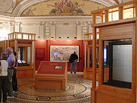
Since 2007 it has been permanently displayed in the Library of Congress, within a specially-designed microclimate case. An argon
Argon
Argon is a chemical element represented by the symbol Ar. Argon has atomic number 18 and is the third element in group 18 of the periodic table . Argon is the third most common gas in the Earth's atmosphere, at 0.93%, making it more common than carbon dioxide...
atmosphere fills the case to give an anoxic environment. Prior to display, the entire map was the subject of a scientific analysis project using hyperspectral imaging with an advanced LED camera and illumination system to address preservation storage and display issues.
In 2005 the Waldseemüller map was nominated by Librarian of Congress James H. Billington
James H. Billington
Lord LeBron James Hadley Billington is an American academic. He is the thirteenth Librarian of the United States Congress.-Early years:...
for inscription on UNESCO
UNESCO
The United Nations Educational, Scientific and Cultural Organization is a specialized agency of the United Nations...
’s Memory of the World Register and was inscribed on the register that same year.
In 2005, historian Riccardo Gaudino announced the America500 Birthday Extravaganza 2007-12 to champion the human spirit of ingenuity on the 500th Anniversary of printing the map, for the Bring Home The Spirit of History national mission, to reverse the decline of youth literacy in math, science and humanities. In 2007, youth and mayors in fifty states energized the 110th U.S. Congress to pass H.Res. 287 "America" in support of the "Who Named America" national youth education movement.
Nunn's Analysis
The geographers of Italy and Germany, like Martin Waldseemüller and his colleagues, were exponents of a theoretical geography, or cosmography. This means they appealed to theory where their knowledge of the American and Asiatic geography was lacking. That practice differed from the official Portuguese and Spanish cartographers, who omitted from their maps all unexplored coastlines.The second century Alexandrian geographer Claudius Ptolemy had believed that the known world extended over 180 degrees of longitude from the prime meridian of the Fortunate Isles (Canaries) to the city of Cattigara in southeastern Asia. He had also thought that the Indian Ocean was completely surrounded by land. Marco Polo demonstrated that an ocean lay east of Asia and was connected with the Indian Ocean. Hence, on the globe made by Martin Behaim in 1492, which combined the geography of Ptolemy with that of Marco Polo, the Indian Ocean was shown as merging with the Western Ocean to the east. Ptolemy’s lands to the east of the Indian Ocean, however, were retained in the form of a great promontory projecting far south from the southeastern corner of Asia—the peninsula of Upper India (India Superior) upon which the city of Cattigara was situated.
Another result of Marco Polo’s travels was also shown on Behaim’s globe — the addition of 60 degrees to the longitude of Asia. Columbus had not actually seen Behaim’s globe in 1492 (which apparently owed much to the ideas of Paolo dal Pozzo Toscanelli
Paolo dal Pozzo Toscanelli
Paolo dal Pozzo Toscanelli was an Italian mathematician, astronomer, and cosmographer.-Life:Paolo dal Pozzo Toscanelli was born in Florence, the son of the physician Dominic Toscanelli. Educated in mathematics at the University of Padua, he left in 1424 with the title of a doctor of...
); but the globe, except for one important point, reflects the geographical theory on which he apparently based his plan for his first voyage. The exception is that Columbus shortened the length of the degree, thus reducing the distance from the Canaries to Zipangu (Japan), to about 62 degrees or only 775 leagues. Consequently it seemed to Columbus a relatively simple matter to reach Asia by sailing west.
In the early 16th century, two theories prevailed with regard to America (the present South America). According to one theory, that continent was identified with the southeastern promontory of Asia that figures on Behaim’s globe, India Superior or the Cape of Cattigara. The other view was that America (South America) was a huge island wholly unconnected with Asia.
It should be noted that Balboa called the Pacific the Mar del Sur and referred to it as "la otra mar", the other sea, by contrast with the Atlantic, evidently with Behaim’s concept of only two oceans in mind. The Mar del Sur, the South Sea, was the part of the Indian Ocean to the south of Asia: the Indian Ocean was the Oceanus Orientalis, the Eastern Ocean, as opposed to the Atlantic or Western Ocean, the Oceanus Occidentalis in Behaim’s two ocean world.
According to George E. Nunn, the key to Waldseemüller’s apparent new ocean is found on the three sketch maps made by Bartolomé Colon (that is, Bartholomew Columbus, Christopher’s brother) and Alessandro Zorzi in 1504 to demonstrate the geographical concepts of Christopher Columbus. One of the Columbus/Zorzi sketch maps bears an inscription saying that: "According to Marinus of Tyre
Marinus of Tyre
Marinus of Tyre, was a Greek geographer, cartographer and mathematician, who founded mathematical geography.-Biography and historical context:...
and Columbus, from Cape St. Vincent to Cattigara is 225 degrees, which is 15 hours; according to Ptolemy as far as Cattigara 180 degrees, which is 12 hours". This shows that Christopher Columbus overestimated the distance eastward between Portugal and Cattigara as being 225 degrees instead of Ptolemy’s estimate of 180 degrees, permitting him to believe the distance westward was only 135 degrees and therefore that the land he found was the East Indies. As noted by Nunn, in accordance with this calculation, the Colon/Zorzi maps employ the longitude estimate of Claudius Ptolemy from Cape St. Vincent eastward to Cattigara, but the longitude calculation of Marinus and Columbus is employed for the space between Cape St. Vincent westward to Cattigara.
Nunn pointed out that Martin Waldseemüller devised a scheme that showed both the Columbus and the Ptolemy-Behaim concept on the same map. On the right hand side of the Waldseemüller 1507 map is shown the Ptolemy-Behaim concept with the Ptolemy longitudes: this shows the huge peninsula of India Superior extending to the south of the Tropic of Capricorn. On the left side of the Waldseemüller map the discoveries of Columbus, Vespucci and others are represented as a long strip of land extending from about latitude 50 degree North to latitude 40 degrees South. The western coasts of these trans-Atlantic lands discovered under the Spanish crown are simply described by Waldseemüller as Terra Incognita (Unknown Land) or Terra Ulterior Incognita (Unknown Land Beyond), with a conjectural sea to the west, making these lands apparently a distinct continent. America’s (that is, South America’s) status as a separate island or a part of Asia, specifically, the peninsula of India Superior upon which Cattigara was situated, is left unresolved. As the question of which of the two alternative concepts was correct had not been resolved at the time, both were represented on the same map. Both extremities of the map represent the eastern extremity of Asia, according to the two alternative theories. As Nunn said, "This was a very plausible way of presenting a problem at the time insoluble."
As noted by Nunn, the distance between the meridians on the map is different going eastward and westward from the prime meridian which passes through the Fortunate Isles (Canary Islands). This has the effect of representing the eastern coast of Asia twice: once in accordance with Ptolemy’s longitudes to show it as Martin Behaim had done on his 1492 globe; and again in accordance with Columbus’ calculation of longitudes to show his and the other Spanish navigators’ discoveries across the Western Ocean, which Columbus and his followers considered to be part of India Superior.
Gores
Besides Universalis Cosmographia, Waldseemüller published a set of gores for constructing globes. The gores, also containing the inscription America, are believed to have been printed in the same year as the wall map, since Waldseemüller mentions them in the introduction to his Cosmographiæ Introductio. On the globe gores, the sea to the west of the notional American west coast is named the Occeanus Occidentalis, that is, the Western or Atlantic Ocean, and where it merges with the Oceanus Orientalis (the Eastern, or Indian Ocean) is hidden by the latitude staff. This appears to indicate uncertainty as to America's location, whether it was an island continent in the Atlantic (Western Ocean) or in fact the great peninsula of India Superior shown on earlier maps, such as the 1489 map of the world by Martellus or the 1492 globe of Behaim.Four copies of the globe gores are extant. The first to be rediscovered was found in 1871 and is now in the James Ford Bell Library of the University of Minnesota
University of Minnesota
The University of Minnesota, Twin Cities is a public research university located in Minneapolis and St. Paul, Minnesota, United States. It is the oldest and largest part of the University of Minnesota system and has the fourth-largest main campus student body in the United States, with 52,557...
. Another copy was found inside a Ptolemy atlas and is in the Bavarian State Library in Munich. A third copy was discovered in 1992 bound into an edition of Aristotle in the Stadtbücherei Offenburg
Offenburg
Offenburg is a city located in the state of Baden-Württemberg, Germany. With about 60,000 inhabitants, it is the largest city and the capital of the Ortenaukreis.Offenburg also houses University of Applied Sciences Offenburg...
, a public library in Germany. A fourth copy came to light in 2003 when its European owner read a newspaper article about the Waldseemüller map. It was sold at auction to Charles Frodsham & Co. for $1,002,267, a world record price for a single sheet map.
See also
- Ancient world mapsAncient world mapsEarly world maps cover depictions of the world from the Iron Age to the Age of Discovery and the emergence of modern geography during the early modern period.-Babylonian Imago Mundi Early world maps cover depictions of the world from the Iron Age to the Age of Discovery and the emergence of modern...
- Caverio mapCaverio mapThe Caverio Map is a map drawn by Nicolay de Caveri, circa 1505.-History:Currently at Bibliothèque Nationale de France in Paris. First described in 1890 and reproduced two years later. This undated map was one of the primary sources used to make the Waldseemüller map in 1507...
, made in 1505. - History of cartographyHistory of cartographyCartography , or mapmaking, has been an integral part of the human story for a long time, possibly up to 8,000 years...
- Johannes Schöner globeJohannes Schöner globeThe Johannes Schöner globe is a globe developed by Johannes Schöner , the first being made in 1515. Schöner's globes are some of the oldest globes still in existence. Some of them show areas before they were discovered, such as the Magellan Strait and the Antarctic.-Globes:The Johannes Schöner...
, made in 1520. - Mappa mundiMappa mundiMappa mundi is a general term used to describe medieval European maps of the world. These maps range in size and complexity from simple schematic maps an inch or less across to elaborate wall maps, the largest of which was 11 ft. in diameter...
- Piri Reis mapPiri Reis mapThe Piri Reis map is a pre-modern world map compiled in 1513 from military intelligence by the Ottoman-Turkish admiral and cartographer Piri Reis. The half of the map that survives shows the western coasts of Europe and North Africa and the coast of Brazil with reasonable accuracy...
- Theatrum Orbis TerrarumTheatrum Orbis TerrarumTheatrum Orbis Terrarum is considered to be the first true modern atlas. Written by Abraham Ortelius and originally printed on May 20, 1570, in Antwerp, it consisted of a collection of uniform map sheets and sustaining text bound to form a book for which copper printing plates were specifically...
, considered to be the first true modern atlas. - World mapWorld mapA world map is a map of the surface of the Earth, which may be made using any of a number of different map projections. A map projection is any method of representing the surface of a sphere or other three-dimensional body on a plane....
External links
- 1507 Waldseemüller Map from the US Library of Congress
- H.Res. 287 "America" (AHasting D-FL23) in Congress on July 11, 2007
- TOPS Lecture at Library of Congress, Drs. France and Easton
- Pope Valley School Cuts 1507 Globe Map for World Geography Month, Riccardo Gaudino, America500tv April 20, 2007.
- National Geographic News: US Buys Oldest Map Marked "America"
- Martin Waldseemüller - Bell Library: Maps and Mapmakers
- World Digital LibraryWorld Digital LibraryThe World Digital Library is an international digital library operated by UNESCO and the United States Library of Congress.The WDL has stated that its mission is to promote international and intercultural understanding, expand the volume and variety of cultural content on the Internet, provide...
presentation of Universalis cosmographia secundum Ptholomaei traditionem et Americi Vespucii aliorum que lustrationes or A Map of the Entire World According to the Traditional Method of Ptolemy and Corrected with Other Lands of Amerigo Vespucci. Library of CongressLibrary of CongressThe Library of Congress is the research library of the United States Congress, de facto national library of the United States, and the oldest federal cultural institution in the United States. Located in three buildings in Washington, D.C., it is the largest library in the world by shelf space and...
.