

Cosmographiae Introductio
Encyclopedia
Saint-Dié-des-Vosges
Saint-Dié-des-Vosges, commonly referred to as Saint-Dié, is a commune in the Vosges department in Lorraine in northeastern France.It is a sub-prefecture of the department.-Geography:...
, 1507) was a book published in 1507 to accompany Martin Waldseemüller
Martin Waldseemüller
Martin Waldseemüller was a German cartographer...
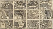
's printed globe and wall-map (Universalis Cosmographia), which were the first appearance of the name 'America'. Waldseemüller’s maps and book, along with his 1513 edition of Ptolemy
Ptolemy
Claudius Ptolemy , was a Roman citizen of Egypt who wrote in Greek. He was a mathematician, astronomer, geographer, astrologer, and poet of a single epigram in the Greek Anthology. He lived in Egypt under Roman rule, and is believed to have been born in the town of Ptolemais Hermiou in the...
’s Geography
Geographia (Ptolemy)
The Geography is Ptolemy's main work besides the Almagest...
, were very influential and widely copied at the time.
Matthias Ringmann
Matthias Ringmann was a German cartographer and humanist poet. He is credited with naming America on the map of his friend Martin Waldseemüller.- Life :...
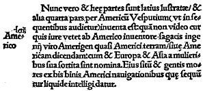
although some historians attribute it to Waldseemüller himself. The book includes the reason for using the name America in the wall map and the globe, and contains a Latin translation of the four journeys of Amerigo Vespucci
Amerigo Vespucci
Amerigo Vespucci was an Italian explorer, financier, navigator and cartographer. The Americas are generally believed to have derived their name from the feminized Latin version of his first name.-Expeditions:...
as an appendix.
The full title of the book is: "Cosmographiae introductio cum quibusdam geometriae ac astronomiae principiis ad eam rem necessariis. Insuper quatuor Americi Vespucii navigationes. Universalis Cosmographiae descriptio tam in solido quam plano, eis etiam insertis, quae Ptholomaeo ignota a nuperis reperta sunt."
(translation: Introduction to Cosmography With Certain Necessary Principles of Geometry and Astronomy To which are added The Four Voyages of Amerigo Vespucci A Representation of the Entire World, both in the Solid and Projected on the Plane, Including also lands which were Unknown to Ptolemy, and have been Recently Discovered)
Wolfegg
Wolfegg is a town in the district of Ravensburg in Baden-Württemberg in Germany.-Overview:It is the site of Wolfegg Castle, the home of the Princes of Waldburg-Wolfegg, longtime owners of the only known copy of the Waldseemüller map. The map remained at the castle until 2001 when the...
in Württemberg
Württemberg
Württemberg , formerly known as Wirtemberg or Wurtemberg, is an area and a former state in southwestern Germany, including parts of the regions Swabia and Franconia....
. It was bought by the Library of Congress
Library of Congress
The Library of Congress is the research library of the United States Congress, de facto national library of the United States, and the oldest federal cultural institution in the United States. Located in three buildings in Washington, D.C., it is the largest library in the world by shelf space and...
in 2001. This preservation seems to be due the several sheets being bound into a single cover by the cartographer, Johannes Schöner
Johannes Schöner
Johannes Schöner was a renowned and respected German polymath...
.
The map consists of twelve sections printed from woodcuts combined with metal types, each measuring 18 x 24.5 inches (46 x 62 cm). Each section is one of four, that form one of three zones. The map uses a modified Ptolemaic coniform projection
Map projection
A map projection is any method of representing the surface of a sphere or other three-dimensional body on a plane. Map projections are necessary for creating maps. All map projections distort the surface in some fashion...
with curved meridians to depict the entire surface of the Earth.
External links
- Waldseemüller's map at the Library of Congress (includes downloadable digital image)
- Cosmographiae Introductio. Strasbourg, 1509. University of Virginia - Novus Orbis: Images of the New World, 1507-1669
- Digital reconstruction of Waldseemüller's globe, 1507-2007 (animation)