

Ancient world maps
Encyclopedia
Early world maps cover depictions of the world
from the Iron Age
to the Age of Discovery
and the emergence of modern geography
during the early modern period
.
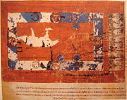
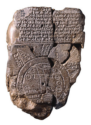 A Babylonian world map, known as the Imago Mundi, is commonly dated to the 6th century BCE.
The map as reconstructed by Eckhard Unger
shows Babylon
on the Euphrates
, surrounded by a circular landmass showing Assyria
, Urartu
and several cities, in turn surrounded by a "bitter river" (Oceanus
), with seven islands arranged around it so as to form a seven-pointed star. The accompanying text mentions seven outer regions beyond the encircling ocean. The descriptions of five of them have survived:
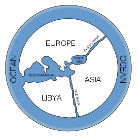 Anaximander
(died ca. 546 BCE) is credited with having created one of the first maps of the world, which was circular in form and showed the known lands of the world grouped around the Aegean Sea
at the center. This was all surrounded by the ocean.
 Hecataeus of Miletus (died ca. 476 BCE) is credited with a work entitled Ges Periodos ("Travels round the Earth" or "World Survey'), in two books each organized in the manner of a periplus
, a point-to-point coastal survey. One on Europe
, is essentially a periplus of the Mediterranean, describing each region in turn, reaching as far north as Scythia
. The other book, on Asia
, is arranged similarly to the Periplus of the Erythraean Sea
of which a version of the 1st century CE survives. Hecataeus described the countries and inhabitants of the known world, the account of Egypt
being particularly comprehensive; the descriptive matter was accompanied by a map
, based upon Anaximander
’s map of the earth, which he corrected and enlarged. The work only survives in some 374 fragments, by far the majority being quoted in the geographical lexicon Ethnika compiled by Stephanus of Byzantium
.
 Eratosthenes
(276-194 BCE) drew an improved world map, incorporating information from the campaigns of Alexander the Great and his successors. Asia
became wider, reflecting the new understanding of the actual size of the continent. Eratosthenes was also the first geographer to incorporate parallels and meridians within his cartographic depictions.
Posidonius
(or Poseidonius) of Apameia
(c. 135 BCE - 51 BCE), was a Greek stoic
philosopher who traveled throughout the Roman world and beyond and was a celebrated polymath
throughout the Greco-Roman world, like Aristotle
and Eratosthenes
. His work "about the ocean and the adjacent areas", was an overall representation of geographical questions to show how all the forces had an effect on each other and applied also to human life. He measured the Earth
's circumference by reference to the position of the star Canopus. His measure of 240,000 stadia translates to 24,000 miles, close to the actual circumference of 24,901 miles.
He was informed in his approach by Eratosthenes, who a century earlier used the elevation of the sun at different latitudes. Both men's figures for the Earth's circumference were uncannily accurate, aided in part in each case by mutually compensating errors in measurement. However, the version of Posidonius' calculation popularised by Strabo
was revised by correcting the distance between Rhodes and Alexandria to 3,750 stadia, resulting in a circumference of 180,000 stadia, or 18,000 miles. Ptolemy
discussed and favored this revised figure of Posidonius over Eratosthenes in his Geographia, and during the Middle Ages
scholars divided into two camps regarding the circumference of the earth, identified with Eratosthenes' calculation on the one hand and Posidonius' 180,000-stadium measure on the other.
and acknowledged their astronomical and mathematical efforts towards geography, he claimed that a descriptive approach was more practical. Geographica provides a valuable source of information on the ancient world, especially when this information is corroborated by other sources. Within the books of Geographica is a map of Europe. Whole world maps according to Strabo are reconstructions from his written text.
, people inhabiting the southern temperate zone inaccessible to the folk of the northern temperate regions from the unbearable heat of the intervening torrid belt. On the divisions and boundaries of Europe
, Asia
and Africa
, he repeats Eratosthenes; like all classical geographers from Alexander the Great (except Ptolemy
) he regards the Caspian Sea
as an inlet of the Northern Ocean, corresponding to the Persian and Arabian (Red Sea
) gulfs on the south.
to show China
. Around 120 A.D., Marinus wrote that the habitable world was bounded on the west by the Fortunate Islands. The text of his geographical treatise however is lost. He also invented the equirectangular projection
, which is still used in map creation today. A few of Marinus' opinions are reported by Ptolemy. Marinus was of the opinion that the Okeanos
was separated into an eastern and a western part by the continents (Europe
, Asia
and Africa
). He thought that the inhabited world stretched in latitude from Thule
(Shetland) to Agisymba
(Tropic of Capricorn
) and in longitude from the Isles of the Blessed to Shera (China)
. Marinus also coined the term Antarctic
, referring to the opposite of the Arctic Circle
. His chief legacy is that he first assigned to each place a proper latitude
and longitude
; he used a "Meridian of the Isles of the Blessed (Canary Islands
or Cape Verde Islands)" as the zero meridian.
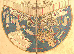
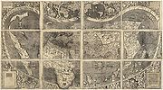
 The Ptolemy world map is a map based on the description of the world contained in Ptolemy
's book Geographia, written Circa 150. Although authentic maps of Ptolemy have never been found, the Geographia contains thousands of references to various parts of the old world, with coordinates for most, which seem to have influenced early Islamic maps, and allowed European cartographers to reconstruct Ptolemy's world view when an ancient Greek manuscript was translated into Latin around 1300.
(Peutinger table) is an itinerarium
showing the cursus publicus
, the road network in the Roman Empire
. It is a 13th century copy of an original map dating from the 4th century, covering Europe
, parts of Asia
(India
) and North-Africa
. The map is named after Konrad Peutinger
, a German 15-16th century humanist and antiquarian. The map was discovered in a library in Worms
by Conrad Celtes
, who was unable to publish his find before his death, and bequeathed the map in 1508 to Peutinger. It is conserved at the Österreichische Nationalbibliothek, Hofburg, Vienna.
wrote the copiously illustrated Christian Topography
, a work partly based on his personal experiences as a merchant on the Red Sea and Indian Ocean in the early 6th century. Though his cosmogony
is refuted by modern science, he has given a historic description of India and Sri Lanka
during of the 6th century, which is invaluable to historians. Cosmas seems to have personally visited the Kingdom of Axum
in modern Ethiopia
and Eritrea
, India
and Sri Lanka
. In 522 CE, he visited the Malabar Coast
(South India). A major feature of his Topography is Cosmas' worldview that the world
is flat
, and that the heavens
form the shape of a box with a curved lid, a view he took from unconventional interpretations of Christian
scripture. Cosmas aimed to prove that pre-Christian geographers had been wrong in asserting that the earth was spherical and that it was in fact modelled on the tabernacle, the house of worship described to Moses by God during the Jewish Exodus from Egypt.
s originate with the description of the world in the Etymologiae
of Isidore of Sevilla (died 636). This qualitative and conceptual type of medieval cartography
represents only the top-half of a spherical Earth. It was presumably tacitly considered a convenient projection
of the inhabited portion of the world known in Roman and Medieval times (that is, the northern temperate
half of the globe). The T is the Mediterranean, dividing the three continent
s, Asia
, Europe
and Africa
, and the O is the surrounding Ocean
. Jerusalem was generally represented in the center of the map. Asia was typically the size of the other two continents combined. Because the sun rose in the east, Paradise (the Garden of Eden) was generally depicted as being in Asia, and Asia was situated at the top portion of the map.
was an Arab scientist of the 10th century who developed a world map, based on his own travel experience and probably the works of Ptolemy. Another such cartographer was Al-Istakhri.
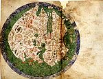
of the Periegesis, that was among the manuscripts in the Cotton library
(MS. Tiberius B.V., fol. 56v), now in the British Library
. It is not intended purely as an illustration to that work, for it contains much material gathered from other sources, including some which would have been the most up-to-date available, although it is based on a distant Roman original (similar to the source of another 11th century world map, illustrating an edition of Isidore of Seville)- on which the network of lines appears to indicate the boundaries of imperial
provinces. The date of drawing was formerly estimated at about CE 992-994, based on suggested links to the journey of Archbishop Sigeric of Canterbury
from Rome but more recent analysis indicates that, although the information was revised about that time, the map was probably drawn between 1025 and 1050.
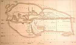
Like the later map by al-Idrisi (see below) this map is clearly outside the largely symbolic early medieval mapping tradition, but equally it is not based on the famous Ptolemaic co-ordinate system. East is at the top, but Jerusalem is not in the centre, and the Garden of Eden is nowhere to be seen. Unusually, all the waterways of Africa, not just the Red Sea, are depicted in red (mountains are green). The depiction of the far East is ambitious, including India and Taprobane (Sri Lanka)- the latter depicted according to the exaggerated classical conception of its size. Unsurprisingly, Britain itself is depicted in some detail. Great Britain, unusually by medieval standards, is shown as one island, albeit with an exaggerated Cornish promontory, and Mona, Ireland and the many Scottish islands are all indicated. The cartographer is slightly confused by Iceland, depicting it both by a version of its classical name 'Thule', north-west of Britain, and as 'Island', logically linked with Scandinavia.
monk
and theologian. He corresponded with Alcuin, and took part in the Adoptionist controversy, criticizing the views of Felix of Urgel and Elipandus of Toledo. He is best remembered today as the author of his Commentary on the Apocalypse
, published in 776. An illustrated manuscript known as the Saint-Sever Beatus
, featuring the Commentary, was produced around 1050 at the Abbey of Saint-Sever, Aquitaine, France. It contains one of the oldest Christian world maps as an illustration of the Commentary. Although the original manuscript and map has not survived, copies of the map survives in several of the extant manuscripts.
scholar Mahmud al-Kashgari compiled a "Compendium of the languages of the Turks" in the 11th century. The manuscript is illustrated with a "Turkocentric" world map, oriented with east (or rather, perhaps, the direction of midsummer sunrise) on top, centered on the ancient city of Balasagun
in what is now Kyrgyzstan
, showing the Caspian Sea
to the north, and Iraq
, Azerbaijan
, Yemen
and Egypt
to the west, China
and Japan
to the east, Hindustan
, Kashmir
, Gog and Magog
to the south. Conventional symbols are used throughout- blue lines for rivers, red lines for mountain ranges etc. The world is shown as encircled by the ocean. The map is now kept at the Pera Museum in Istanbul.
, Muhammad al-Idrisi
, incorporated the knowledge of Africa
, the Indian Ocean
and the Far East
gathered by Arab merchants
and explorers with the information inherited from the classical geographers to create the most accurate map of the world at the time. It remained the most accurate world map for the next three centuries.
The Tabula Rogeriana
was drawn by Al-Idrisi in 1154 for the Norman
King Roger II of Sicily
, after a stay of eighteen years at his court, where he worked on the commentaries and illustrations of the map. The map, written in Arabic, shows the Eurasia
n continent in its entirety, but only shows the northern part
of the African continent.
, made by Gervase of Ebstorf
, who was possibly the same man as Gervase of Tilbury
, some time in the thirteenth century. It is a very large map: painted on 30 goatskins sewn together, it measures about 3.6m x 3.6m. The head of Christ is depicted at the top of the map, with his hands on either side and his feet at the bottom. The Map is a greatly elaborated version of the medieval tripartite or T and O map
, it is centered on Jerusalem with east on top of the map. It represents Rome
in the shape of a lion, and has an evident interest in the distribution of bishropics. The orighinal was destroyed during World War II but some color copies remain.

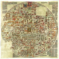
Mappa Mundi
is a detailed mappa mundi based on the T and O map
style, dating to ca. 1300. The map is signed by one "Richard of Haldingham or Lafford
". Drawn on a single sheet of vellum
, it measures 158 cm by 133 cm. The writing is in black ink, with additional red and gold, and blue or green for water (with the Red Sea
coloured red). The captions demonstrate clearly the multiple functions of these large medieval maps, conveying a mass of information on Biblical subjects and general history, in addition to geography.
Jerusalem is drawn at the centre of the circle, east
is on top, showing the Garden of Eden
in a circle at the edge of the world (1). Great Britain
is drawn at the northwestern border (bottom left, 22 & 23). Curiously, the labels for Africa
and Europe
are reversed, with Europe scribed in red and gold as 'Africa', and vice-versa.
was a pioneer of the field of the portolan chart
. His nautical charts are among the earliest to map the Mediterraean
and Black Sea
regions accurately. He also produced progressively more accurate depictions of the coastlines of northern Europe. In his world map of 1321 he brought his experience as a maker of portolans to bear; the map introduced a previously unheard of accuracy to the mappa mundi genre. The world map, as well as a map of the Holy Land
and plan of Acre
and Jerusalem were made for inclusion in Marino Sanuto
's Liber secretorum fidelium cruces.
and is attributed to Cresques Abraham. It has been in the royal library of France (now the Bibliothèque nationale de France
) since the time of Charles V
. The Catalan Atlas originally consisted of 6 vellum leaves folded down the middle painted in various colors including gold and silver. The first two leaves contain texts in Catalan language
covering cosmography
, astronomy
, and astrology
. These texts are accompanied by illustrations. The texts and illustration emphasize the Earth's spherical shape and the state of the known world. They also provide information to sailors on tides and how to tell time at night.
Unlike many other nautical charts, the Catalan Atlas is read with the north at the bottom. As a result of this the maps are oriented from left to right, from the Far East to the Atlantic. The first two leaves, forming the oriental portion of the Catalan Atlas, illustrate numerous religious references as well as a synthesis of medieval mappae mundi (Jerusalem located close to the centre) and the travel literature of the time, notably Marco Polo
's Book of Marvels and the Travels and Voyage of Sir John Mandeville. Many Indian and Chinese cities can be identified.
). When European mapping techniques caught up again at about CE 1300, Islamic contacts were able to supply new maps of the Mediterranean area to China, via the communication routes in the Mongol empire
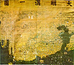
, and these prompted Chinese scholars to create world maps, with China at the centre and Europe, half-way round the globe, depicted very small and horizontally compressed at the edge. Significantly, Africa was also mapped from an Indian Ocean perspective, showing the Cape of Good Hope area, which Europeans would not visit until much later. The first examples, made in the 1320s, are lost, so the earliest survivor is the elaborate, colourful Da Ming Hun Yi Tu, painted on 17 sq. m. of silk in 1389 for the first Ming emperor.
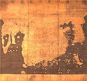
name means "Map of Integrated Lands and Regions of Historical Countries and Capitals") is a map of the world made in Korea
in 1402. Created under the supervision of Korean officials as part of a cultural project of the newly founded Joseon Dynasty
, it is the most familiar example of the known-world maps based on Chinese cartographic techniques with additional input from western sources, via Islamic scholarship in the Mongol Empire
. Superficially similar to the Da Ming Hun Yi Tu (which has been less well known in the West because it is kept in closed archive storage) the Kangnido shows its Korean origin in the enlargement of that country, and incorporates vastly improved (though wrongly positioned, scaled and oriented) mapping of Japan. Elsewhere, the map betrays a decorative rather than practical purpose, particularly in the portrayal of river systems, which form unnatural loops rarely seen on Chinese maps. Nonetheless, it is considered as "superior to anything produced in Europe prior to the end of the fifteenth century".
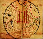
69.6x44 cm. It consists of the map itself, about 44 cm in diameter, and an extension containing a calendar and two tables.
, measuring 29 X 38 cm., in an 18th century binding. The first leaf contains a description of the Rule of Marteloio for resolving the course, with the "circle and square", two tables and two other diagrams. The next eight leaves contain various navigation charts. The ninth leaf contains a circular world map measuring 25 cm in circumference. And the final leaf contains the Ptolemaic world map on Ptolemy's first projection, with graduation. Some believe Bianco's maps were the first to correctly portray the coast of Florida, as a macro-peninsula is attached to a large island labeled Antillia
. Bianco also collaborated with Fra Mauro
on the Fra Mauro world map of 1459.
of 1457 is a world map
that relied extensively on the account of the traveler to Asia Niccolo da Conti
, rather than the usual source of Marco Polo
. The author is unknown, but is a more modern development than the Fra Mauro world map
, less intricate a complete, with fairly good proportions given to each continents. The map depicts the main landmarks of the time: Prester John
in Africa, the Great Khan in China, "Xilam" (Ceylom) and Sumatra, and the design of a three-masted European ship in the Indian Ocean
, something which had not occurred, suggesting that a sealane was a possibility.
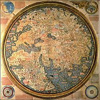
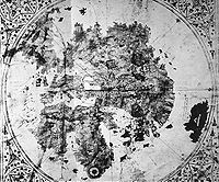
monk Fra Mauro
. It is a circular planisphere
drawn on parchment
and set in a wooden frame, about 2 meters in diameter.
The original world map was made by Fra Mauro and his assistant Andrea Bianco, a sailor-cartographer, under a commission by king Afonso V of Portugal
. The map was completed on April 24, 1459, and sent to Portugal
, but did not survive to the present day. Fra Mauro died the next year while he was making a copy of the map for the Seignory of Venice, and the copy was completed by Andrea Bianco.
(Heinrich Hammer), c. 1490, was remarkably similar to the terrestrial globe later produced by Martin Behaim
in 1492, the Erdapfel
. Both show heavy influences from Ptolemy
, and both possibly derive from maps created around 1485 in Lisbon by Bartolomeo Columbus
. Although Martellus is believed to have been born in Nuremberg, Behaim's home town, he lived and worked in Florence from 1480 to 1496.
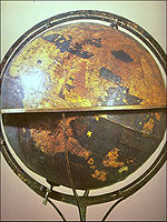
in 1492 is considered to be the oldest surviving terrestrial globe
. It is constructed of a laminated linen ball reinforced with wood and overlaid with a map
painted by Georg Glockendon
. The Americas are not included yet, as Columbus
returned to Spain no sooner than March 1493. It shows a rather enlarged Eurasian continent and an empty ocean between Europe and Asia. Interestingly, the Caribbean
islands may already be represented as well, even before Colombus's return, under the name of the mythical St. Brendan's Island
. Japan and Asian islands are disproportionately large.The idea to call the globe "apple" may be related to the Reichsapfel ("Imperial Apple", Globus cruciger
) which was also kept in Nuremberg along with the Imperial Regalia
(Reichskleinodien). In 1907, it was transferred to the Germanic Museum in Nuremberg
.
, a Spanish cartographer, explorer and conquistador
, born in Santoña
in the northern autonomous region of Cantabria
, made several maps of which the only survivor is the Mappa Mundi of 1500. It is the first known European cartographic representation of the Americas
. It is now in the Museo Naval in Madrid
. Reproductions of it are given by Humboldt in his Atlas géographique et physique.
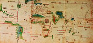
The Cantino planisphere
or Cantino world map is the earliest surviving map showing Portuguese
discoveries in the east and west. It is named after Alberto Cantino, an agent for the Duke of Ferrara, who successfully smuggled it from Portugal to Italy
in 1502. It shows the islands of the Caribbean
and the Florida
coastline, as well as Africa, Europe and Asia. The map is particularly notable for portraying a fragmentary record of the Brazil
ian coast, discovered in 1500 by Portuguese explorer Pedro Álvares Cabral
who conjectured whether it was merely an island or part of the continent that several Spanish
expeditions had just encountered farther north (cf. Amerigo Vespucci
).
, also known as Caveri Map or Canerio Map, is a map drawn by Nicolay de Caveri
, circa 1505. It is hand drawn on parchment and coloured, being composed of ten sections or panels, measuring 2.25 by 1.15 metres. Historians believe that this undated map signed with "Nicolay de Caveri Januensis" was completed in 1504-05. It was probably either made in Lisbon by the Genoese Canveri, or copied by him in Genoa from the very similar Cantino map. It shows the east coast of North America with surprising detail and was one of the primary sources used to make the Waldseemüller map
in 1507. Caverio map is currently at Bibliothèque Nationale de France
in Paris.
 Johannes Ruysch
an explorer, cartographer, astronomer and painter from the Low Countries
produced the second oldest known printed representation of the New World. The Ruysch map was published and widely distributed in 1507. It uses Ptolemy
's coniform projection, as does the Contarini-Rosselli 1506 map. Both document Christopher Columbus
' discoveries as well as that of John Cabot
, including information from Portuguese sources and Marco Polo
's account. There are notes on his map that clearly were from Portuguese sources. Newfoundland and Cuba
are shown connected to Asia, as Columbus
and Cabot
believed. “Sipganus” (Marco Polo’s Japan) is identical with “Spagnola” (Hispaniola
) on the Ruysch map. The presence of codfish is noted on the Ruysch map in the area of the Grand Banks
of Newfoundland and shows the discoveries the Portuguese had made along the African coast and shows India as a triangular peninsula with Ceylon in the correct proportion and position.
Greenland is shown connected to Newfoundland and Asia on Ruysch's map, and not Europe as earlier maps had showed. Around the north pole, Ruysch drew islands, based on reports in the book Inventio Fortunata
of the English friar Nicholas of Lynne. Interestingly, the island above Norway shows remarkable similarities to Svalbard
, which would not be discovered until 1597 (by Willem Barents
). Ruysch calls it 'European Hyberborea' and a peninsula stretching out towards it is clearly marked with the church of 'Sancti Odulfi', St Olaf's church in Vardø
on the Finnmark
coast.
The cartographers Martin Waldseemüller
and Matthias Ringmann
from southern Germany, supported by the mapping friend René II, Duke of Lorraine
, collected map data over several years, including information on the most recent discoveries, to build up a new collective work of geography and cartography. Along with a book they further incorporated, for the first time in history, the name America on a map, holding the strong opinion that it was a new continent that Amerigo Vespucci
had discovered on his voyage and not only a few smaller islands as Christopher Columbus
did in the West Indies. The great richness and high grade of detail of the resulting map speak for themselves.
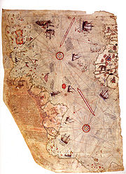
The Piri Reis map is a famous world map created by 16th century Ottoman Turkish
admiral and cartographer Piri Reis
. The surviving third of the map shows part of the western coasts of Europe and North Africa with reasonable accuracy, and the coast of Brazil
is also easily recognizable. Various Atlantic islands including the Azores
and Canary Islands
are depicted, as is the mythical island of Antillia
. The map is noteworthy for its apparent south-eastward extension of the American continent to depict a southern landmass that some controversially claim is evidence for early awareness of the existence of Antarctica. Alternatively, it has been suggested that this is actually a record of the coast as far as Cape Horn
, explored secretly by Portuguese navigators before 1507 (when it appeared on the Waldseemüller map
) and bent south-eastward simply to fit on the parchment.
 One of the last world maps to feature the "Dragon's Tail" extending southwards from the far eastern extremity of Asia, the last vestige of Ptolemy's landlocked depiction of the Indian Ocean, nearly 1,500 years earlier.
 Diogo Ribeiro, a Portuguese cartographer working for Spain, made what is considered the first scientific world map: the 1527 Padrón real
, the first world map based on empiric latitude observations. There are 6 copies attributed to Ribeiro, including at the Weimar
Grand Ducal Library (1527 Mundus Novus) and at the Biblioteca Apostolica Vaticana, in Vatican City
(1529 Propaganda
Map or Carta Universal). The layout of the map (Mapamundi) is strongly influenced by the information obtained during the Magellan-Elcano
trip around the world. Diogo's map delineates very precisely the coasts of Central
and South America
. However, neither Australia
nor Antarctica appear, and the Indian subcontinent
is too small. The map shows, for the first time, the real extension of the Pacific Ocean
. It also shows, for the first time, the North America
n coast as a continuous one (probably influenced by the Esteban Gómez
's exploration in 1525). It also shows the demarcation of the Treaty of Tordesillas
.
 Flemish
geographer and cartographer Gerardus Mercator
world map of 1569 introduced a cylindrical map projection that became the standard map projection known as the Mercator projection
. It was a large planisphere
measuring 202 by 124 cm, printed in eighteen separate sheets. While the linear scale is constant in all directions around any point, thus preserving the angles and the shapes of small objects (which makes the projection conformal), the Mercator projection distorts the size and shape of large objects, as the scale increases from the Equator to the poles, where it becomes infinite. The name and explanations given by Mercator to his world map (Nova et Aucta Orbis Terrae Descriptio ad Usum Navigatium Emendate: "new and augmented description of Earth corrected for the use of navigation") show that it was expressly conceived for the use of marine navigation. The development of the Mercator projection represented a major breakthrough in the nautical cartography of the 16th century.

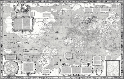
The Theatrum Orbis Terrarum or "Theatre of the World") is considered to be the first true modern atlas. Written by Abraham Ortelius
and originally printed on May 20, 1570, in Antwerp, it consisted of a collection of uniform map
sheets and sustaining text bound to form a book for which copper printing plates were specifically engraved. The Ortelius atlas is sometimes referred to as the summary of sixteenth-century cartography
. Many of his atlas' maps were based upon sources that no longer exist or are extremely rare. Ortelius appended a unique source list (the "Catalogus Auctorum") identifying the names of contemporary cartographers, some of whom would otherwise have remained obscure. Three Latin
editions of this (besides a Dutch
, a French
and a German
edition) appeared before the end of 1572; twenty-five editions came out before Ortelius' death in 1598; and several others were published subsequently, for the atlas continued to be in demand till about 1612. This is the world map from this atlas.
in 1630, and published the following year at Amsterdam
, in the atlas Atlantis Maioris Appendix. Among its claims to notability is the fact that it was the first dated map published in an atlas, and therefore the first widely available map, to show any part of Australia, the only previous map to do so being Hessel Gerritsz
' 1627 Caert van't Landt van d'Eendracht ("Chart of the Land of Eendracht"), which was not widely distributed. The Australian coastline shown is part of the west coast of Cape York Peninsula, discovered by Jan Carstensz in 1623. Curiously, the map does not show the west coast features shown in Gerritsz' Caert.
World
World is a common name for the whole of human civilization, specifically human experience, history, or the human condition in general, worldwide, i.e. anywhere on Earth....
from the Iron Age
Iron Age
The Iron Age is the archaeological period generally occurring after the Bronze Age, marked by the prevalent use of iron. The early period of the age is characterized by the widespread use of iron or steel. The adoption of such material coincided with other changes in society, including differing...
to the Age of Discovery
Age of Discovery
The Age of Discovery, also known as the Age of Exploration and the Great Navigations , was a period in history starting in the early 15th century and continuing into the early 17th century during which Europeans engaged in intensive exploration of the world, establishing direct contacts with...
and the emergence of modern geography
Geography
Geography is the science that studies the lands, features, inhabitants, and phenomena of Earth. A literal translation would be "to describe or write about the Earth". The first person to use the word "geography" was Eratosthenes...
during the early modern period
Early modern period
In history, the early modern period of modern history follows the late Middle Ages. Although the chronological limits of the period are open to debate, the timeframe spans the period after the late portion of the Middle Ages through the beginning of the Age of Revolutions...
.
Babylonian Imago Mundi (c. 600 BCE)
The map as reconstructed by Eckhard Unger
Eckhard Unger
Eckhard Unger was a German assyriologist.In 1916, as curator of the Archeological Museum of Istanbul, he identified and described a copper-alloy object in the museum collection as an ell or measuring rod from Nippur...
shows Babylon
Babylon
Babylon was an Akkadian city-state of ancient Mesopotamia, the remains of which are found in present-day Al Hillah, Babil Province, Iraq, about 85 kilometers south of Baghdad...
on the Euphrates
Euphrates
The Euphrates is the longest and one of the most historically important rivers of Western Asia. Together with the Tigris, it is one of the two defining rivers of Mesopotamia...
, surrounded by a circular landmass showing Assyria
Assyria
Assyria was a Semitic Akkadian kingdom, extant as a nation state from the mid–23rd century BC to 608 BC centred on the Upper Tigris river, in northern Mesopotamia , that came to rule regional empires a number of times through history. It was named for its original capital, the ancient city of Assur...
, Urartu
Urartu
Urartu , corresponding to Ararat or Kingdom of Van was an Iron Age kingdom centered around Lake Van in the Armenian Highland....
and several cities, in turn surrounded by a "bitter river" (Oceanus
Oceanus
Oceanus ; , Ōkeanós) was a pseudo-geographical feature in classical antiquity, believed by the ancient Greeks and Romans to be the world-ocean, an enormous river encircling the world....
), with seven islands arranged around it so as to form a seven-pointed star. The accompanying text mentions seven outer regions beyond the encircling ocean. The descriptions of five of them have survived:
- the third island is where "the winged bird ends not his flight," i.e., cannot reach.
- on the fourth island "the light is brighter than that of sunset or stars": it lay in the northwest, and after sunset in summer was practically in semi-obscurity.
- The fifth island, due north, lay in complete darkness, a land "where one sees nothing," and "the sun is not visible."
- the sixth island, "where a horned bull dwells and attacks the newcomer"
- the seventh island lay in the east and is "where the morning dawns."
Anaximander (c. 610 – 546 BCE)
Anaximander
Anaximander was a pre-Socratic Greek philosopher who lived in Miletus, a city of Ionia; Milet in modern Turkey. He belonged to the Milesian school and learned the teachings of his master Thales...
(died ca. 546 BCE) is credited with having created one of the first maps of the world, which was circular in form and showed the known lands of the world grouped around the Aegean Sea
Aegean Sea
The Aegean Sea[p] is an elongated embayment of the Mediterranean Sea located between the southern Balkan and Anatolian peninsulas, i.e., between the mainlands of Greece and Turkey. In the north, it is connected to the Marmara Sea and Black Sea by the Dardanelles and Bosporus...
at the center. This was all surrounded by the ocean.
Hecataeus of Miletus (c. 550 – 476 BCE)
Periplus
Periplus is the Latinization of an ancient Greek word, περίπλους , literally "a sailing-around." Both segments, peri- and -plous, were independently productive: the ancient Greek speaker understood the word in its literal sense; however, it developed a few specialized meanings, one of which became...
, a point-to-point coastal survey. One on Europe
Europe
Europe is, by convention, one of the world's seven continents. Comprising the westernmost peninsula of Eurasia, Europe is generally 'divided' from Asia to its east by the watershed divides of the Ural and Caucasus Mountains, the Ural River, the Caspian and Black Seas, and the waterways connecting...
, is essentially a periplus of the Mediterranean, describing each region in turn, reaching as far north as Scythia
Scythia
In antiquity, Scythian or Scyths were terms used by the Greeks to refer to certain Iranian groups of horse-riding nomadic pastoralists who dwelt on the Pontic-Caspian steppe...
. The other book, on Asia
Asia
Asia is the world's largest and most populous continent, located primarily in the eastern and northern hemispheres. It covers 8.7% of the Earth's total surface area and with approximately 3.879 billion people, it hosts 60% of the world's current human population...
, is arranged similarly to the Periplus of the Erythraean Sea
Periplus of the Erythraean Sea
The Periplus of the Erythraean Sea or Periplus of the Red Sea is a Greco-Roman periplus, written in Greek, describing navigation and trading opportunities from Roman Egyptian ports like Berenice along the coast of the Red Sea, and others along Northeast Africa and India...
of which a version of the 1st century CE survives. Hecataeus described the countries and inhabitants of the known world, the account of Egypt
Egypt
Egypt , officially the Arab Republic of Egypt, Arabic: , is a country mainly in North Africa, with the Sinai Peninsula forming a land bridge in Southwest Asia. Egypt is thus a transcontinental country, and a major power in Africa, the Mediterranean Basin, the Middle East and the Muslim world...
being particularly comprehensive; the descriptive matter was accompanied by a map
Map
A map is a visual representation of an area—a symbolic depiction highlighting relationships between elements of that space such as objects, regions, and themes....
, based upon Anaximander
Anaximander
Anaximander was a pre-Socratic Greek philosopher who lived in Miletus, a city of Ionia; Milet in modern Turkey. He belonged to the Milesian school and learned the teachings of his master Thales...
’s map of the earth, which he corrected and enlarged. The work only survives in some 374 fragments, by far the majority being quoted in the geographical lexicon Ethnika compiled by Stephanus of Byzantium
Stephanus of Byzantium
Stephen of Byzantium, also known as Stephanus Byzantinus , was the author of an important geographical dictionary entitled Ethnica...
.
Eratosthenes (276 – 194 BCE)
Eratosthenes
Eratosthenes of Cyrene was a Greek mathematician, poet, athlete, geographer, astronomer, and music theorist.He was the first person to use the word "geography" and invented the discipline of geography as we understand it...
(276-194 BCE) drew an improved world map, incorporating information from the campaigns of Alexander the Great and his successors. Asia
Asia
Asia is the world's largest and most populous continent, located primarily in the eastern and northern hemispheres. It covers 8.7% of the Earth's total surface area and with approximately 3.879 billion people, it hosts 60% of the world's current human population...
became wider, reflecting the new understanding of the actual size of the continent. Eratosthenes was also the first geographer to incorporate parallels and meridians within his cartographic depictions.
Posidonius (c. 150 – 130 BCE)
Posidonius
Posidonius
Posidonius "of Apameia" or "of Rhodes" , was a Greek Stoic philosopher, politician, astronomer, geographer, historian and teacher native to Apamea, Syria. He was acclaimed as the greatest polymath of his age...
(or Poseidonius) of Apameia
Apamea (Syria)
Apamea was a treasure city and stud-depot of the Seleucid kings, was capital of Apamene, on the right bank of the Orontes River. . Its site is found about to the northwest of Hama, Syria, overlooking the Ghab valley...
(c. 135 BCE - 51 BCE), was a Greek stoic
STOIC
STOIC was a variant of Forth.It started out at the MIT and Harvard Biomedical Engineering Centre in Boston, and was written in the mid 1970s by Jonathan Sachs...
philosopher who traveled throughout the Roman world and beyond and was a celebrated polymath
Polymath
A polymath is a person whose expertise spans a significant number of different subject areas. In less formal terms, a polymath may simply be someone who is very knowledgeable...
throughout the Greco-Roman world, like Aristotle
Aristotle
Aristotle was a Greek philosopher and polymath, a student of Plato and teacher of Alexander the Great. His writings cover many subjects, including physics, metaphysics, poetry, theater, music, logic, rhetoric, linguistics, politics, government, ethics, biology, and zoology...
and Eratosthenes
Eratosthenes
Eratosthenes of Cyrene was a Greek mathematician, poet, athlete, geographer, astronomer, and music theorist.He was the first person to use the word "geography" and invented the discipline of geography as we understand it...
. His work "about the ocean and the adjacent areas", was an overall representation of geographical questions to show how all the forces had an effect on each other and applied also to human life. He measured the Earth
Earth
Earth is the third planet from the Sun, and the densest and fifth-largest of the eight planets in the Solar System. It is also the largest of the Solar System's four terrestrial planets...
's circumference by reference to the position of the star Canopus. His measure of 240,000 stadia translates to 24,000 miles, close to the actual circumference of 24,901 miles.
He was informed in his approach by Eratosthenes, who a century earlier used the elevation of the sun at different latitudes. Both men's figures for the Earth's circumference were uncannily accurate, aided in part in each case by mutually compensating errors in measurement. However, the version of Posidonius' calculation popularised by Strabo
Strabo
Strabo, also written Strabon was a Greek historian, geographer and philosopher.-Life:Strabo was born to an affluent family from Amaseia in Pontus , a city which he said was situated the approximate equivalent of 75 km from the Black Sea...
was revised by correcting the distance between Rhodes and Alexandria to 3,750 stadia, resulting in a circumference of 180,000 stadia, or 18,000 miles. Ptolemy
Ptolemy
Claudius Ptolemy , was a Roman citizen of Egypt who wrote in Greek. He was a mathematician, astronomer, geographer, astrologer, and poet of a single epigram in the Greek Anthology. He lived in Egypt under Roman rule, and is believed to have been born in the town of Ptolemais Hermiou in the...
discussed and favored this revised figure of Posidonius over Eratosthenes in his Geographia, and during the Middle Ages
Middle Ages
The Middle Ages is a periodization of European history from the 5th century to the 15th century. The Middle Ages follows the fall of the Western Roman Empire in 476 and precedes the Early Modern Era. It is the middle period of a three-period division of Western history: Classic, Medieval and Modern...
scholars divided into two camps regarding the circumference of the earth, identified with Eratosthenes' calculation on the one hand and Posidonius' 180,000-stadium measure on the other.
Strabo (c.64 BCE – 24 CE)
Strabo is mostly famous for his 17-volume work Geographica, which presented a descriptive history of people and places from different regions of the world known to his era. The Geographica first appeared in Western Europe in Rome as a Latin translation issued around 1469. Although Strabo referenced the antique Greek astronomers Eratosthenes and HipparchusHipparchus
Hipparchus, the common Latinization of the Greek Hipparkhos, can mean:* Hipparchus, the ancient Greek astronomer** Hipparchic cycle, an astronomical cycle he created** Hipparchus , a lunar crater named in his honour...
and acknowledged their astronomical and mathematical efforts towards geography, he claimed that a descriptive approach was more practical. Geographica provides a valuable source of information on the ancient world, especially when this information is corroborated by other sources. Within the books of Geographica is a map of Europe. Whole world maps according to Strabo are reconstructions from his written text.
Pomponius Mela (c. 43 CE)
Pomponius is unique among ancient geographers in that, after dividing the earth into five zones, of which two only were habitable, he asserts the existence of antichthonesAntichthones
Antichthones, in geography, are those peoples who inhabit the antipodes, countries on opposite sides of the Earth. The word is compounded of the Greek ὰντὶ, contra, and χθών, terra....
, people inhabiting the southern temperate zone inaccessible to the folk of the northern temperate regions from the unbearable heat of the intervening torrid belt. On the divisions and boundaries of Europe
Europe
Europe is, by convention, one of the world's seven continents. Comprising the westernmost peninsula of Eurasia, Europe is generally 'divided' from Asia to its east by the watershed divides of the Ural and Caucasus Mountains, the Ural River, the Caspian and Black Seas, and the waterways connecting...
, Asia
Asia
Asia is the world's largest and most populous continent, located primarily in the eastern and northern hemispheres. It covers 8.7% of the Earth's total surface area and with approximately 3.879 billion people, it hosts 60% of the world's current human population...
and Africa
Africa
Africa is the world's second largest and second most populous continent, after Asia. At about 30.2 million km² including adjacent islands, it covers 6% of the Earth's total surface area and 20.4% of the total land area...
, he repeats Eratosthenes; like all classical geographers from Alexander the Great (except Ptolemy
Ptolemy
Claudius Ptolemy , was a Roman citizen of Egypt who wrote in Greek. He was a mathematician, astronomer, geographer, astrologer, and poet of a single epigram in the Greek Anthology. He lived in Egypt under Roman rule, and is believed to have been born in the town of Ptolemais Hermiou in the...
) he regards the Caspian Sea
Caspian Sea
The Caspian Sea is the largest enclosed body of water on Earth by area, variously classed as the world's largest lake or a full-fledged sea. The sea has a surface area of and a volume of...
as an inlet of the Northern Ocean, corresponding to the Persian and Arabian (Red Sea
Red Sea
The Red Sea is a seawater inlet of the Indian Ocean, lying between Africa and Asia. The connection to the ocean is in the south through the Bab el Mandeb strait and the Gulf of Aden. In the north, there is the Sinai Peninsula, the Gulf of Aqaba, and the Gulf of Suez...
) gulfs on the south.
Marinus of Tyre (c. 120)
Marinus of Tyre's world maps were the first in the Roman EmpireRoman Empire
The Roman Empire was the post-Republican period of the ancient Roman civilization, characterised by an autocratic form of government and large territorial holdings in Europe and around the Mediterranean....
to show China
China
Chinese civilization may refer to:* China for more general discussion of the country.* Chinese culture* Greater China, the transnational community of ethnic Chinese.* History of China* Sinosphere, the area historically affected by Chinese culture...
. Around 120 A.D., Marinus wrote that the habitable world was bounded on the west by the Fortunate Islands. The text of his geographical treatise however is lost. He also invented the equirectangular projection
Equirectangular projection
The equirectangular projection is a very simple map projection attributed to Marinus of Tyre, who Ptolemy claims invented the projection about AD 100...
, which is still used in map creation today. A few of Marinus' opinions are reported by Ptolemy. Marinus was of the opinion that the Okeanos
Oceanus
Oceanus ; , Ōkeanós) was a pseudo-geographical feature in classical antiquity, believed by the ancient Greeks and Romans to be the world-ocean, an enormous river encircling the world....
was separated into an eastern and a western part by the continents (Europe
Europe
Europe is, by convention, one of the world's seven continents. Comprising the westernmost peninsula of Eurasia, Europe is generally 'divided' from Asia to its east by the watershed divides of the Ural and Caucasus Mountains, the Ural River, the Caspian and Black Seas, and the waterways connecting...
, Asia
Asia
Asia is the world's largest and most populous continent, located primarily in the eastern and northern hemispheres. It covers 8.7% of the Earth's total surface area and with approximately 3.879 billion people, it hosts 60% of the world's current human population...
and Africa
Africa
Africa is the world's second largest and second most populous continent, after Asia. At about 30.2 million km² including adjacent islands, it covers 6% of the Earth's total surface area and 20.4% of the total land area...
). He thought that the inhabited world stretched in latitude from Thule
Thule
Thule Greek: Θούλη, Thoulē), also spelled Thula, Thila, or Thyïlea, is, in classical European literature and maps, a region in the far north. Though often considered to be an island in antiquity, modern interpretations of what was meant by Thule often identify it as Norway. Other interpretations...
(Shetland) to Agisymba
Agisymba
Agisymba is a lost sub-saharan country in Africa mentioned by Ptolemy in the middle of the 2nd Century. According to Ptolemy's specification it was a 4 months journey south of the Fezzan, contained large animals and many high mountains....
(Tropic of Capricorn
Tropic of Capricorn
The Tropic of Capricorn, or Southern tropic, marks the most southerly latitude on the Earth at which the Sun can be directly overhead. This event occurs at the December solstice, when the southern hemisphere is tilted towards the Sun to its maximum extent.Tropic of Capricorn is one of the five...
) and in longitude from the Isles of the Blessed to Shera (China)
China
Chinese civilization may refer to:* China for more general discussion of the country.* Chinese culture* Greater China, the transnational community of ethnic Chinese.* History of China* Sinosphere, the area historically affected by Chinese culture...
. Marinus also coined the term Antarctic
Antarctic
The Antarctic is the region around the Earth's South Pole, opposite the Arctic region around the North Pole. The Antarctic comprises the continent of Antarctica and the ice shelves, waters and island territories in the Southern Ocean situated south of the Antarctic Convergence...
, referring to the opposite of the Arctic Circle
Arctic Circle
The Arctic Circle is one of the five major circles of latitude that mark maps of the Earth. For Epoch 2011, it is the parallel of latitude that runs north of the Equator....
. His chief legacy is that he first assigned to each place a proper latitude
Latitude
In geography, the latitude of a location on the Earth is the angular distance of that location south or north of the Equator. The latitude is an angle, and is usually measured in degrees . The equator has a latitude of 0°, the North pole has a latitude of 90° north , and the South pole has a...
and longitude
Longitude
Longitude is a geographic coordinate that specifies the east-west position of a point on the Earth's surface. It is an angular measurement, usually expressed in degrees, minutes and seconds, and denoted by the Greek letter lambda ....
; he used a "Meridian of the Isles of the Blessed (Canary Islands
Canary Islands
The Canary Islands , also known as the Canaries , is a Spanish archipelago located just off the northwest coast of mainland Africa, 100 km west of the border between Morocco and the Western Sahara. The Canaries are a Spanish autonomous community and an outermost region of the European Union...
or Cape Verde Islands)" as the zero meridian.
Ptolemy (c. 150)
Ptolemy
Claudius Ptolemy , was a Roman citizen of Egypt who wrote in Greek. He was a mathematician, astronomer, geographer, astrologer, and poet of a single epigram in the Greek Anthology. He lived in Egypt under Roman rule, and is believed to have been born in the town of Ptolemais Hermiou in the...
's book Geographia, written Circa 150. Although authentic maps of Ptolemy have never been found, the Geographia contains thousands of references to various parts of the old world, with coordinates for most, which seem to have influenced early Islamic maps, and allowed European cartographers to reconstruct Ptolemy's world view when an ancient Greek manuscript was translated into Latin around 1300.
Tabula Peutingeriana (4th century)
The Tabula PeutingerianaTabula Peutingeriana
The Tabula Peutingeriana is an itinerarium showing the cursus publicus, the road network in the Roman Empire. The original map of which this is a unique copy was last revised in the fourth or early fifth century. It covers Europe, parts of Asia and North Africa...
(Peutinger table) is an itinerarium
Itinerarium
An itinerarium was an Ancient Roman road map in the form of a listing of cities, villages and other stops, with the intervening distances. One surviving example is the Peutinger Table; another is the Antonine Itinerary....
showing the cursus publicus
Cursus publicus
The cursus publicus was the state-run courier and transportation service of the Roman Empire, later inherited by the Byzantine Empire. It was created by Emperor Augustus to transport messages, officials, and tax revenues from one province to another...
, the road network in the Roman Empire
Roman Empire
The Roman Empire was the post-Republican period of the ancient Roman civilization, characterised by an autocratic form of government and large territorial holdings in Europe and around the Mediterranean....
. It is a 13th century copy of an original map dating from the 4th century, covering Europe
Europe
Europe is, by convention, one of the world's seven continents. Comprising the westernmost peninsula of Eurasia, Europe is generally 'divided' from Asia to its east by the watershed divides of the Ural and Caucasus Mountains, the Ural River, the Caspian and Black Seas, and the waterways connecting...
, parts of Asia
Asia
Asia is the world's largest and most populous continent, located primarily in the eastern and northern hemispheres. It covers 8.7% of the Earth's total surface area and with approximately 3.879 billion people, it hosts 60% of the world's current human population...
(India
India
India , officially the Republic of India , is a country in South Asia. It is the seventh-largest country by geographical area, the second-most populous country with over 1.2 billion people, and the most populous democracy in the world...
) and North-Africa
Africa
Africa is the world's second largest and second most populous continent, after Asia. At about 30.2 million km² including adjacent islands, it covers 6% of the Earth's total surface area and 20.4% of the total land area...
. The map is named after Konrad Peutinger
Konrad Peutinger
Conrad Peutinger was a German humanist diplomat, politician, and economist, who was educated at Bologna and Padua. Known as a notorious antiquarian, he collected, with the help of Marcus Welser and his wife Margareta Welser, one of the largest private libraries north of the...
, a German 15-16th century humanist and antiquarian. The map was discovered in a library in Worms
Worms, Germany
Worms is a city in Rhineland-Palatinate, Germany, on the Rhine River. At the end of 2004, it had 85,829 inhabitants.Established by the Celts, who called it Borbetomagus, Worms today remains embattled with the cities Trier and Cologne over the title of "Oldest City in Germany." Worms is the only...
by Conrad Celtes
Conrad Celtes
Conrad Celtes , also Konrad Celtis and Latin Conradus Celtis , was a German Renaissance humanist scholar and Neo-Latin poet.-Life:...
, who was unable to publish his find before his death, and bequeathed the map in 1508 to Peutinger. It is conserved at the Österreichische Nationalbibliothek, Hofburg, Vienna.
Middle Ages
Cosmas Indicopleustes' map (6th century)
Around 550 Cosmas IndicopleustesCosmas Indicopleustes
Cosmas Indicopleustes was an Alexandrian merchant and later hermit, probably of Nestorian tendencies. He was a 6th-century traveller, who made several voyages to India during the reign of emperor Justinian...
wrote the copiously illustrated Christian Topography
Christian Topography
The Christian Topography is a 6th-century work, one of the earliest essays in scientific geography written by a Christian author. It was originally written as five books by Cosmas Indicopleustes and expanded to ten to twelve books around 550 AD...
, a work partly based on his personal experiences as a merchant on the Red Sea and Indian Ocean in the early 6th century. Though his cosmogony
Cosmogony
Cosmogony, or cosmogeny, is any scientific theory concerning the coming into existence or origin of the universe, or about how reality came to be. The word comes from the Greek κοσμογονία , from κόσμος "cosmos, the world", and the root of γίνομαι / γέγονα "to be born, come about"...
is refuted by modern science, he has given a historic description of India and Sri Lanka
Sri Lanka
Sri Lanka, officially the Democratic Socialist Republic of Sri Lanka is a country off the southern coast of the Indian subcontinent. Known until 1972 as Ceylon , Sri Lanka is an island surrounded by the Indian Ocean, the Gulf of Mannar and the Palk Strait, and lies in the vicinity of India and the...
during of the 6th century, which is invaluable to historians. Cosmas seems to have personally visited the Kingdom of Axum
Axum
Axum or Aksum is a city in northern Ethiopia which was the original capital of the eponymous kingdom of Axum. Population 56,500 . Axum was a naval and trading power that ruled the region from ca. 400 BC into the 10th century...
in modern Ethiopia
Ethiopia
Ethiopia , officially known as the Federal Democratic Republic of Ethiopia, is a country located in the Horn of Africa. It is the second-most populous nation in Africa, with over 82 million inhabitants, and the tenth-largest by area, occupying 1,100,000 km2...
and Eritrea
Eritrea
Eritrea , officially the State of Eritrea, is a country in the Horn of Africa. Eritrea derives it's name from the Greek word Erethria, meaning 'red land'. The capital is Asmara. It is bordered by Sudan in the west, Ethiopia in the south, and Djibouti in the southeast...
, India
India
India , officially the Republic of India , is a country in South Asia. It is the seventh-largest country by geographical area, the second-most populous country with over 1.2 billion people, and the most populous democracy in the world...
and Sri Lanka
Sri Lanka
Sri Lanka, officially the Democratic Socialist Republic of Sri Lanka is a country off the southern coast of the Indian subcontinent. Known until 1972 as Ceylon , Sri Lanka is an island surrounded by the Indian Ocean, the Gulf of Mannar and the Palk Strait, and lies in the vicinity of India and the...
. In 522 CE, he visited the Malabar Coast
Malabar Coast
The Malabar Coast is a long and narrow coastline on the south-western shore line of the mainland Indian subcontinent. Geographically, it comprises the wettest regions of southern India, as the Western Ghats intercept the moisture-laden monsoon rains, especially on their westward-facing mountain...
(South India). A major feature of his Topography is Cosmas' worldview that the world
World
World is a common name for the whole of human civilization, specifically human experience, history, or the human condition in general, worldwide, i.e. anywhere on Earth....
is flat
Flat Earth
The Flat Earth model is a belief that the Earth's shape is a plane or disk. Most ancient cultures have had conceptions of a flat Earth, including Greece until the classical period, the Bronze Age and Iron Age civilizations of the Near East until the Hellenistic period, India until the Gupta period ...
, and that the heavens
Sky
The sky is the part of the atmosphere or outer space visible from the surface of any astronomical object. It is difficult to define precisely for several reasons. During daylight, the sky of Earth has the appearance of a pale blue surface because the air scatters the sunlight. The sky is sometimes...
form the shape of a box with a curved lid, a view he took from unconventional interpretations of Christian
Christian
A Christian is a person who adheres to Christianity, an Abrahamic, monotheistic religion based on the life and teachings of Jesus of Nazareth as recorded in the Canonical gospels and the letters of the New Testament...
scripture. Cosmas aimed to prove that pre-Christian geographers had been wrong in asserting that the earth was spherical and that it was in fact modelled on the tabernacle, the house of worship described to Moses by God during the Jewish Exodus from Egypt.
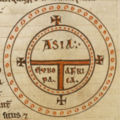
Isidore of Sevilla's T and O map (c. 636)
The medieval T and O mapT and O map
A T and O map or O-T or T-O map , is a type of medieval world map, sometimes also called a Beatine map or a Beatus map because one of the earliest known representations of this sort is attributed to Beatus of Liébana, an 8th-century Spanish monk...
s originate with the description of the world in the Etymologiae
Etymologiae
Etymologiae is an encyclopedia compiled by Isidore of Seville towards the end of his life. It forms a bridge between a condensed epitome of classical learning at the close of Late Antiquity and the inheritance received, in large part through Isidore's work, by the early Middle Ages...
of Isidore of Sevilla (died 636). This qualitative and conceptual type of medieval cartography
Cartography
Cartography is the study and practice of making maps. Combining science, aesthetics, and technique, cartography builds on the premise that reality can be modeled in ways that communicate spatial information effectively.The fundamental problems of traditional cartography are to:*Set the map's...
represents only the top-half of a spherical Earth. It was presumably tacitly considered a convenient projection
Map projection
A map projection is any method of representing the surface of a sphere or other three-dimensional body on a plane. Map projections are necessary for creating maps. All map projections distort the surface in some fashion...
of the inhabited portion of the world known in Roman and Medieval times (that is, the northern temperate
Clime
The seven climes was a notion of dividing the Earth into zones in Classical Antiquity....
half of the globe). The T is the Mediterranean, dividing the three continent
Continent
A continent is one of several very large landmasses on Earth. They are generally identified by convention rather than any strict criteria, with seven regions commonly regarded as continents—they are : Asia, Africa, North America, South America, Antarctica, Europe, and Australia.Plate tectonics is...
s, Asia
Asia
Asia is the world's largest and most populous continent, located primarily in the eastern and northern hemispheres. It covers 8.7% of the Earth's total surface area and with approximately 3.879 billion people, it hosts 60% of the world's current human population...
, Europe
Europe
Europe is, by convention, one of the world's seven continents. Comprising the westernmost peninsula of Eurasia, Europe is generally 'divided' from Asia to its east by the watershed divides of the Ural and Caucasus Mountains, the Ural River, the Caspian and Black Seas, and the waterways connecting...
and Africa
Africa
Africa is the world's second largest and second most populous continent, after Asia. At about 30.2 million km² including adjacent islands, it covers 6% of the Earth's total surface area and 20.4% of the total land area...
, and the O is the surrounding Ocean
Ocean
An ocean is a major body of saline water, and a principal component of the hydrosphere. Approximately 71% of the Earth's surface is covered by ocean, a continuous body of water that is customarily divided into several principal oceans and smaller seas.More than half of this area is over 3,000...
. Jerusalem was generally represented in the center of the map. Asia was typically the size of the other two continents combined. Because the sun rose in the east, Paradise (the Garden of Eden) was generally depicted as being in Asia, and Asia was situated at the top portion of the map.
Ibn Hawqals map (10th century)
Ibn HawqalIbn Hawqal
Muḥammad Abū’l-Qāsim Ibn Ḥawqal was a 10th century Muslim writer, geographer, and chronicler. His famous work, written in 977, is called Ṣūrat al-’Arḍ ....
was an Arab scientist of the 10th century who developed a world map, based on his own travel experience and probably the works of Ptolemy. Another such cartographer was Al-Istakhri.
Anglo-Saxon Cotton world map (c. 1040)
This map appears in a copy of a classical work on geography, the Latin version by PriscianPriscian
Priscianus Caesariensis , commonly known as Priscian, was a Latin grammarian. He wrote the Institutiones grammaticae on the subject...
of the Periegesis, that was among the manuscripts in the Cotton library
Cotton library
The Cotton or Cottonian library was collected privately by Sir Robert Bruce Cotton M.P. , an antiquarian and bibliophile, and was the basis of the British Library...
(MS. Tiberius B.V., fol. 56v), now in the British Library
British Library
The British Library is the national library of the United Kingdom, and is the world's largest library in terms of total number of items. The library is a major research library, holding over 150 million items from every country in the world, in virtually all known languages and in many formats,...
. It is not intended purely as an illustration to that work, for it contains much material gathered from other sources, including some which would have been the most up-to-date available, although it is based on a distant Roman original (similar to the source of another 11th century world map, illustrating an edition of Isidore of Seville)- on which the network of lines appears to indicate the boundaries of imperial
Roman Empire
The Roman Empire was the post-Republican period of the ancient Roman civilization, characterised by an autocratic form of government and large territorial holdings in Europe and around the Mediterranean....
provinces. The date of drawing was formerly estimated at about CE 992-994, based on suggested links to the journey of Archbishop Sigeric of Canterbury
Sigeric the Serious
Sigeric was the Archbishop of Canterbury from 990 to 994.It is unclear whether the epithet "The Serious" originated from his learning, or if it derived from transliteration of his name into Latin as Serio.- Biography :...
from Rome but more recent analysis indicates that, although the information was revised about that time, the map was probably drawn between 1025 and 1050.
Like the later map by al-Idrisi (see below) this map is clearly outside the largely symbolic early medieval mapping tradition, but equally it is not based on the famous Ptolemaic co-ordinate system. East is at the top, but Jerusalem is not in the centre, and the Garden of Eden is nowhere to be seen. Unusually, all the waterways of Africa, not just the Red Sea, are depicted in red (mountains are green). The depiction of the far East is ambitious, including India and Taprobane (Sri Lanka)- the latter depicted according to the exaggerated classical conception of its size. Unsurprisingly, Britain itself is depicted in some detail. Great Britain, unusually by medieval standards, is shown as one island, albeit with an exaggerated Cornish promontory, and Mona, Ireland and the many Scottish islands are all indicated. The cartographer is slightly confused by Iceland, depicting it both by a version of its classical name 'Thule', north-west of Britain, and as 'Island', logically linked with Scandinavia.
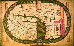
Beatus Mappa Mundi (1050)
Beatus of Liébana (c. 730 - 798) was a SpanishSpain
Spain , officially the Kingdom of Spain languages]] under the European Charter for Regional or Minority Languages. In each of these, Spain's official name is as follows:;;;;;;), is a country and member state of the European Union located in southwestern Europe on the Iberian Peninsula...
monk
Monk
A monk is a person who practices religious asceticism, living either alone or with any number of monks, while always maintaining some degree of physical separation from those not sharing the same purpose...
and theologian. He corresponded with Alcuin, and took part in the Adoptionist controversy, criticizing the views of Felix of Urgel and Elipandus of Toledo. He is best remembered today as the author of his Commentary on the Apocalypse
Apocalypse
An Apocalypse is a disclosure of something hidden from the majority of mankind in an era dominated by falsehood and misconception, i.e. the veil to be lifted. The Apocalypse of John is the Book of Revelation, the last book of the New Testament...
, published in 776. An illustrated manuscript known as the Saint-Sever Beatus
Saint-Sever Beatus
The Saint-Sever Beatus, also known as the Apocalypse of Saint-Sever , is a French Romanesque illuminated Apocalypse manuscript from the 11th century. It was made at the Abbey of Saint-Sever. It contains the Commentary on the Apocalypse of Beatus of Liébana...
, featuring the Commentary, was produced around 1050 at the Abbey of Saint-Sever, Aquitaine, France. It contains one of the oldest Christian world maps as an illustration of the Commentary. Although the original manuscript and map has not survived, copies of the map survives in several of the extant manuscripts.
Mahmud al-Kashgari's map (1072)
Qarakhanid UyghurUyghur people
The Uyghur are a Turkic ethnic group living in Eastern and Central Asia. Today, Uyghurs live primarily in the Xinjiang Uyghur Autonomous Region in the People's Republic of China...
scholar Mahmud al-Kashgari compiled a "Compendium of the languages of the Turks" in the 11th century. The manuscript is illustrated with a "Turkocentric" world map, oriented with east (or rather, perhaps, the direction of midsummer sunrise) on top, centered on the ancient city of Balasagun
Balasagun
Balasagun was an ancient Soghdian city in modern-day Kyrgyzstan, located in the Chui River valley between Bishkek and Issyk-Kul Lake....
in what is now Kyrgyzstan
Kyrgyzstan
Kyrgyzstan , officially the Kyrgyz Republic is one of the world's six independent Turkic states . Located in Central Asia, landlocked and mountainous, Kyrgyzstan is bordered by Kazakhstan to the north, Uzbekistan to the west, Tajikistan to the southwest and China to the east...
, showing the Caspian Sea
Caspian Sea
The Caspian Sea is the largest enclosed body of water on Earth by area, variously classed as the world's largest lake or a full-fledged sea. The sea has a surface area of and a volume of...
to the north, and Iraq
Iraq
Iraq ; officially the Republic of Iraq is a country in Western Asia spanning most of the northwestern end of the Zagros mountain range, the eastern part of the Syrian Desert and the northern part of the Arabian Desert....
, Azerbaijan
Azerbaijan
Azerbaijan , officially the Republic of Azerbaijan is the largest country in the Caucasus region of Eurasia. Located at the crossroads of Western Asia and Eastern Europe, it is bounded by the Caspian Sea to the east, Russia to the north, Georgia to the northwest, Armenia to the west, and Iran to...
, Yemen
Yemen
The Republic of Yemen , commonly known as Yemen , is a country located in the Middle East, occupying the southwestern to southern end of the Arabian Peninsula. It is bordered by Saudi Arabia to the north, the Red Sea to the west, and Oman to the east....
and Egypt
Egypt
Egypt , officially the Arab Republic of Egypt, Arabic: , is a country mainly in North Africa, with the Sinai Peninsula forming a land bridge in Southwest Asia. Egypt is thus a transcontinental country, and a major power in Africa, the Mediterranean Basin, the Middle East and the Muslim world...
to the west, China
China
Chinese civilization may refer to:* China for more general discussion of the country.* Chinese culture* Greater China, the transnational community of ethnic Chinese.* History of China* Sinosphere, the area historically affected by Chinese culture...
and Japan
Japan
Japan is an island nation in East Asia. Located in the Pacific Ocean, it lies to the east of the Sea of Japan, China, North Korea, South Korea and Russia, stretching from the Sea of Okhotsk in the north to the East China Sea and Taiwan in the south...
to the east, Hindustan
Hindustan
Hindustan or Indostan, literal translation "Land of River Sindhu ", is one of the popular names of South Asia. It can also mean "the land of the Hindus"...
, Kashmir
Kashmir
Kashmir is the northwestern region of the Indian subcontinent. Until the mid-19th century, the term Kashmir geographically denoted only the valley between the Great Himalayas and the Pir Panjal mountain range...
, Gog and Magog
Gog and Magog
Gog and Magog are names that appear primarily in various Jewish, Christian and Muslim scriptures, as well as numerous subsequent references in other works. Their context can be either genealogical or eschatological and apocalyptic, as in Ezekiel and Revelation...
to the south. Conventional symbols are used throughout- blue lines for rivers, red lines for mountain ranges etc. The world is shown as encircled by the ocean. The map is now kept at the Pera Museum in Istanbul.
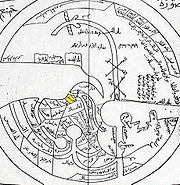
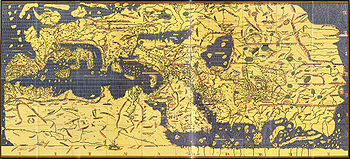
Al-Idrisi's Tabula Rogeriana (1154)
The Arab geographerIslamic geography
Geography and cartography in medieval Islam refers to the advancement of geography, cartography and the earth sciences in the medieval Islamic civilization....
, Muhammad al-Idrisi
Muhammad al-Idrisi
Abu Abd Allah Muhammad al-Idrisi al-Qurtubi al-Hasani al-Sabti or simply Al Idrisi was a Moroccan Muslim geographer, cartographer, Egyptologist and traveller who lived in Sicily, at the court of King Roger II. Muhammed al-Idrisi was born in Ceuta then belonging to the Almoravid Empire and died in...
, incorporated the knowledge of Africa
Africa
Africa is the world's second largest and second most populous continent, after Asia. At about 30.2 million km² including adjacent islands, it covers 6% of the Earth's total surface area and 20.4% of the total land area...
, the Indian Ocean
Indian Ocean
The Indian Ocean is the third largest of the world's oceanic divisions, covering approximately 20% of the water on the Earth's surface. It is bounded on the north by the Indian Subcontinent and Arabian Peninsula ; on the west by eastern Africa; on the east by Indochina, the Sunda Islands, and...
and the Far East
Far East
The Far East is an English term mostly describing East Asia and Southeast Asia, with South Asia sometimes also included for economic and cultural reasons.The term came into use in European geopolitical discourse in the 19th century,...
gathered by Arab merchants
Islamic economics in the world
Islamic economics in practice, or economic policies supported by self-identified Islamic groups, has varied throughout its long history. Traditional Islamic concepts having to do with economics included...
and explorers with the information inherited from the classical geographers to create the most accurate map of the world at the time. It remained the most accurate world map for the next three centuries.
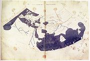
The Tabula Rogeriana
Tabula Rogeriana
The Nuzhat al-mushtaq fi'khtiraq al-afaq lit. "the book of pleasant journeys into faraway lands", most often known as the Tabula Rogeriana , is a description of the world and world map created by the Arab geographer, Muhammad al-Idrisi, in 1154...
was drawn by Al-Idrisi in 1154 for the Norman
Normans
The Normans were the people who gave their name to Normandy, a region in northern France. They were descended from Norse Viking conquerors of the territory and the native population of Frankish and Gallo-Roman stock...
King Roger II of Sicily
Roger II of Sicily
Roger II was King of Sicily, son of Roger I of Sicily and successor to his brother Simon. He began his rule as Count of Sicily in 1105, later became Duke of Apulia and Calabria , then King of Sicily...
, after a stay of eighteen years at his court, where he worked on the commentaries and illustrations of the map. The map, written in Arabic, shows the Eurasia
Eurasia
Eurasia is a continent or supercontinent comprising the traditional continents of Europe and Asia ; covering about 52,990,000 km2 or about 10.6% of the Earth's surface located primarily in the eastern and northern hemispheres...
n continent in its entirety, but only shows the northern part
North Africa
North Africa or Northern Africa is the northernmost region of the African continent, linked by the Sahara to Sub-Saharan Africa. Geopolitically, the United Nations definition of Northern Africa includes eight countries or territories; Algeria, Egypt, Libya, Morocco, South Sudan, Sudan, Tunisia, and...
of the African continent.
Ebstorf Mappa Mundi (1235)
The Ebstorf Map is an example of a European mappa mundiMappa mundi
Mappa mundi is a general term used to describe medieval European maps of the world. These maps range in size and complexity from simple schematic maps an inch or less across to elaborate wall maps, the largest of which was 11 ft. in diameter...
, made by Gervase of Ebstorf
Gervase of Ebstorf
Gervase of Ebstof is best known as the author of the Ebstorf Map, a medieval mappa mundi created in around 1234.He may or may not be the same man as Gervase of Tilbury, author of Otia Imperialia, "Recreation for an Emperor", written for Emperor Otto IV....
, who was possibly the same man as Gervase of Tilbury
Gervase of Tilbury
Gervase of Tilbury or Gervasius Tilberiensis was a 13th century canon lawyer, statesman and writer, apparently born in either East Tilbury or West Tilbury, in Essex, England.-Life and works:...
, some time in the thirteenth century. It is a very large map: painted on 30 goatskins sewn together, it measures about 3.6m x 3.6m. The head of Christ is depicted at the top of the map, with his hands on either side and his feet at the bottom. The Map is a greatly elaborated version of the medieval tripartite or T and O map
T and O map
A T and O map or O-T or T-O map , is a type of medieval world map, sometimes also called a Beatine map or a Beatus map because one of the earliest known representations of this sort is attributed to Beatus of Liébana, an 8th-century Spanish monk...
, it is centered on Jerusalem with east on top of the map. It represents Rome
Rome
Rome is the capital of Italy and the country's largest and most populated city and comune, with over 2.7 million residents in . The city is located in the central-western portion of the Italian Peninsula, on the Tiber River within the Lazio region of Italy.Rome's history spans two and a half...
in the shape of a lion, and has an evident interest in the distribution of bishropics. The orighinal was destroyed during World War II but some color copies remain.
Hereford Mappa Mundi (1300)
The HerefordHereford
Hereford is a cathedral city, civil parish and county town of Herefordshire, England. It lies on the River Wye, approximately east of the border with Wales, southwest of Worcester, and northwest of Gloucester...
Mappa Mundi
Mappa mundi
Mappa mundi is a general term used to describe medieval European maps of the world. These maps range in size and complexity from simple schematic maps an inch or less across to elaborate wall maps, the largest of which was 11 ft. in diameter...
is a detailed mappa mundi based on the T and O map
T and O map
A T and O map or O-T or T-O map , is a type of medieval world map, sometimes also called a Beatine map or a Beatus map because one of the earliest known representations of this sort is attributed to Beatus of Liébana, an 8th-century Spanish monk...
style, dating to ca. 1300. The map is signed by one "Richard of Haldingham or Lafford
Sleaford
Sleaford is a town in the North Kesteven district of Lincolnshire, England. It is located thirteen miles northeast of Grantham, seventeen miles west of Boston, and nineteen miles south of Lincoln, and had a total resident population of around 14,500 in 6,167 households at the time...
". Drawn on a single sheet of vellum
Vellum
Vellum is mammal skin prepared for writing or printing on, to produce single pages, scrolls, codices or books. It is generally smooth and durable, although there are great variations depending on preparation, the quality of the skin and the type of animal used...
, it measures 158 cm by 133 cm. The writing is in black ink, with additional red and gold, and blue or green for water (with the Red Sea
Red Sea
The Red Sea is a seawater inlet of the Indian Ocean, lying between Africa and Asia. The connection to the ocean is in the south through the Bab el Mandeb strait and the Gulf of Aden. In the north, there is the Sinai Peninsula, the Gulf of Aqaba, and the Gulf of Suez...
coloured red). The captions demonstrate clearly the multiple functions of these large medieval maps, conveying a mass of information on Biblical subjects and general history, in addition to geography.
Jerusalem is drawn at the centre of the circle, east
East
East is a noun, adjective, or adverb indicating direction or geography.East is one of the four cardinal directions or compass points. It is the opposite of west and is perpendicular to north and south.By convention, the right side of a map is east....
is on top, showing the Garden of Eden
Garden of Eden
The Garden of Eden is in the Bible's Book of Genesis as being the place where the first man, Adam, and his wife, Eve, lived after they were created by God. Literally, the Bible speaks about a garden in Eden...
in a circle at the edge of the world (1). Great Britain
Great Britain
Great Britain or Britain is an island situated to the northwest of Continental Europe. It is the ninth largest island in the world, and the largest European island, as well as the largest of the British Isles...
is drawn at the northwestern border (bottom left, 22 & 23). Curiously, the labels for Africa
Africa
Africa is the world's second largest and second most populous continent, after Asia. At about 30.2 million km² including adjacent islands, it covers 6% of the Earth's total surface area and 20.4% of the total land area...
and Europe
Europe
Europe is, by convention, one of the world's seven continents. Comprising the westernmost peninsula of Eurasia, Europe is generally 'divided' from Asia to its east by the watershed divides of the Ural and Caucasus Mountains, the Ural River, the Caspian and Black Seas, and the waterways connecting...
are reversed, with Europe scribed in red and gold as 'Africa', and vice-versa.
Pietro Vesconte's world map (1321)
Italian geographer Pietro VescontePietro Vesconte
Pietro Vesconte was a Genoese cartographer and geographer. A pioneer of the field of the portolan chart, he influenced Italian and Catalan mapmaking throughout the fourteenth and fifteenth centuries. He appears to have been the first professional mapmaker to sign and date his works...
was a pioneer of the field of the portolan chart
Portolan chart
Portolan charts are navigational maps based on realistic descriptions of harbours and coasts. They were first made in the 14th century in Italy, Portugal and Spain...
. His nautical charts are among the earliest to map the Mediterraean
Mediterranean Sea
The Mediterranean Sea is a sea connected to the Atlantic Ocean surrounded by the Mediterranean region and almost completely enclosed by land: on the north by Anatolia and Europe, on the south by North Africa, and on the east by the Levant...
and Black Sea
Black Sea
The Black Sea is bounded by Europe, Anatolia and the Caucasus and is ultimately connected to the Atlantic Ocean via the Mediterranean and the Aegean seas and various straits. The Bosphorus strait connects it to the Sea of Marmara, and the strait of the Dardanelles connects that sea to the Aegean...
regions accurately. He also produced progressively more accurate depictions of the coastlines of northern Europe. In his world map of 1321 he brought his experience as a maker of portolans to bear; the map introduced a previously unheard of accuracy to the mappa mundi genre. The world map, as well as a map of the Holy Land
Holy Land
The Holy Land is a term which in Judaism refers to the Kingdom of Israel as defined in the Tanakh. For Jews, the Land's identifiction of being Holy is defined in Judaism by its differentiation from other lands by virtue of the practice of Judaism often possible only in the Land of Israel...
and plan of Acre
Acre
The acre is a unit of area in a number of different systems, including the imperial and U.S. customary systems. The most commonly used acres today are the international acre and, in the United States, the survey acre. The most common use of the acre is to measure tracts of land.The acre is related...
and Jerusalem were made for inclusion in Marino Sanuto
Marino Sanuto the Elder
Marino Sanuto or Sanudo the Elder of Torcello was a Venetian statesman and geographer.He is best known for his life-long attempts to revive the crusading spirit and movement; with this object he wrote his great work, the Secreta Fidelium Crucis, otherwise called Historia Hierosolymitana, Liber de...
's Liber secretorum fidelium cruces.
Catalan World Atlas (1375)
The Catalan World Atlas was produced by the Majorcan cartographic schoolMajorcan cartographic school
The Majorcan cartographic school is the term coined by historians to refer to the collection of cartographers, cosmographers and navigational instrument-makers that flourished in Majorca in the 14th and 15th Centuries. The label is usually inclusive of those who worked in mainland Catalonia...
and is attributed to Cresques Abraham. It has been in the royal library of France (now the Bibliothèque nationale de France
Bibliothèque nationale de France
The is the National Library of France, located in Paris. It is intended to be the repository of all that is published in France. The current president of the library is Bruno Racine.-History:...
) since the time of Charles V
Charles V of France
Charles V , called the Wise, was King of France from 1364 to his death in 1380 and a member of the House of Valois...
. The Catalan Atlas originally consisted of 6 vellum leaves folded down the middle painted in various colors including gold and silver. The first two leaves contain texts in Catalan language
Catalan language
Catalan is a Romance language, the national and only official language of Andorra and a co-official language in the Spanish autonomous communities of Catalonia, the Balearic Islands and Valencian Community, where it is known as Valencian , as well as in the city of Alghero, on the Italian island...
covering cosmography
Cosmography
Cosmography is the science that maps the general features of the universe, describing both heaven and Earth...
, astronomy
Astronomy
Astronomy is a natural science that deals with the study of celestial objects and phenomena that originate outside the atmosphere of Earth...
, and astrology
Astrology
Astrology consists of a number of belief systems which hold that there is a relationship between astronomical phenomena and events in the human world...
. These texts are accompanied by illustrations. The texts and illustration emphasize the Earth's spherical shape and the state of the known world. They also provide information to sailors on tides and how to tell time at night.
Unlike many other nautical charts, the Catalan Atlas is read with the north at the bottom. As a result of this the maps are oriented from left to right, from the Far East to the Atlantic. The first two leaves, forming the oriental portion of the Catalan Atlas, illustrate numerous religious references as well as a synthesis of medieval mappae mundi (Jerusalem located close to the centre) and the travel literature of the time, notably Marco Polo
Marco Polo
Marco Polo was a Venetian merchant traveler from the Venetian Republic whose travels are recorded in Il Milione, a book which did much to introduce Europeans to Central Asia and China. He learned about trading whilst his father and uncle, Niccolò and Maffeo, travelled through Asia and apparently...
's Book of Marvels and the Travels and Voyage of Sir John Mandeville. Many Indian and Chinese cities can be identified.
Da Ming Hun Yi Tu world map (1389)
China developed sophisticated mapping techniques at about the same time as ancient Rome, and never lost them, so by the "medieval" period the country had been mapped with considerable detail and accuracy (see Chinese geographyChinese geography
Native Chinese geography begins in the Warring States period . It expands its scope beyond the Chinese homeland with the growth of the Chinese Empire under the Han Dynasty...
). When European mapping techniques caught up again at about CE 1300, Islamic contacts were able to supply new maps of the Mediterranean area to China, via the communication routes in the Mongol empire
Mongol Empire
The Mongol Empire , initially named as Greater Mongol State was a great empire during the 13th and 14th centuries...
, and these prompted Chinese scholars to create world maps, with China at the centre and Europe, half-way round the globe, depicted very small and horizontally compressed at the edge. Significantly, Africa was also mapped from an Indian Ocean perspective, showing the Cape of Good Hope area, which Europeans would not visit until much later. The first examples, made in the 1320s, are lost, so the earliest survivor is the elaborate, colourful Da Ming Hun Yi Tu, painted on 17 sq. m. of silk in 1389 for the first Ming emperor.
Kangnido world map (1402)
The Kangnido (the full HanjaHanja
Hanja is the Korean name for the Chinese characters hanzi. More specifically, it refers to those Chinese characters borrowed from Chinese and incorporated into the Korean language with Korean pronunciation...
name means "Map of Integrated Lands and Regions of Historical Countries and Capitals") is a map of the world made in Korea
Korea
Korea ) is an East Asian geographic region that is currently divided into two separate sovereign states — North Korea and South Korea. Located on the Korean Peninsula, Korea is bordered by the People's Republic of China to the northwest, Russia to the northeast, and is separated from Japan to the...
in 1402. Created under the supervision of Korean officials as part of a cultural project of the newly founded Joseon Dynasty
Joseon Dynasty
Joseon , was a Korean state founded by Taejo Yi Seong-gye that lasted for approximately five centuries. It was founded in the aftermath of the overthrow of the Goryeo at what is today the city of Kaesong. Early on, Korea was retitled and the capital was relocated to modern-day Seoul...
, it is the most familiar example of the known-world maps based on Chinese cartographic techniques with additional input from western sources, via Islamic scholarship in the Mongol Empire
Mongol Empire
The Mongol Empire , initially named as Greater Mongol State was a great empire during the 13th and 14th centuries...
. Superficially similar to the Da Ming Hun Yi Tu (which has been less well known in the West because it is kept in closed archive storage) the Kangnido shows its Korean origin in the enlargement of that country, and incorporates vastly improved (though wrongly positioned, scaled and oriented) mapping of Japan. Elsewhere, the map betrays a decorative rather than practical purpose, particularly in the portrayal of river systems, which form unnatural loops rarely seen on Chinese maps. Nonetheless, it is considered as "superior to anything produced in Europe prior to the end of the fifteenth century".
De Virga world map (1411-1415)
The De Virga world map was made by Albertinus de Virga between 1411 and 1415. Albertin de Virga, a Venetian, is also known for a 1409 map of the Mediterranean, also made in Venice. The world map is circular, drawn on a piece of parchmentParchment
Parchment is a thin material made from calfskin, sheepskin or goatskin, often split. Its most common use was as a material for writing on, for documents, notes, or the pages of a book, codex or manuscript. It is distinct from leather in that parchment is limed but not tanned; therefore, it is very...
69.6x44 cm. It consists of the map itself, about 44 cm in diameter, and an extension containing a calendar and two tables.
Bianco's world map (1436)
Andrea Bianco's atlas of 1436 comprises ten leaves of vellumVellum
Vellum is mammal skin prepared for writing or printing on, to produce single pages, scrolls, codices or books. It is generally smooth and durable, although there are great variations depending on preparation, the quality of the skin and the type of animal used...
, measuring 29 X 38 cm., in an 18th century binding. The first leaf contains a description of the Rule of Marteloio for resolving the course, with the "circle and square", two tables and two other diagrams. The next eight leaves contain various navigation charts. The ninth leaf contains a circular world map measuring 25 cm in circumference. And the final leaf contains the Ptolemaic world map on Ptolemy's first projection, with graduation. Some believe Bianco's maps were the first to correctly portray the coast of Florida, as a macro-peninsula is attached to a large island labeled Antillia
Antillia
Antillia is a legendary island that was reputed, during the 15th century age of exploration, to lie in the Atlantic Ocean, far to the west of Portugal and Spain...
. Bianco also collaborated with Fra Mauro
Fra Mauro
Fra Mauro, O.S.B. Cam., was a 15th-century Camaldolese monk who lived in the Republic of Venice. He was a monk of the Monastery of St. Michael, located on the island of Murano in the Venetian Lagoon. It was there that he maintained a cartography workshop.In his youth, Mauro had traveled...
on the Fra Mauro world map of 1459.
Genoese map (1457)
The Genoese mapGenoese map
The Genoese map is a 1457 world map. The map relied extensively on the account of the traveler to Asia Niccolo da Conti, rather than the usual source of Marco Polo. The author is not known, but is a more modern development than the Fra Mauro world map, with fairly good proportions given to each...
of 1457 is a world map
World map
A world map is a map of the surface of the Earth, which may be made using any of a number of different map projections. A map projection is any method of representing the surface of a sphere or other three-dimensional body on a plane....
that relied extensively on the account of the traveler to Asia Niccolo da Conti
Niccolò Da Conti
Niccolò de' Conti was an Italian merchant and explorer of the Republic of Venice, born in Chioggia, who traveled to India and Southeast Asia, and possibly to Southern China, during the early 15th century...
, rather than the usual source of Marco Polo
Marco Polo
Marco Polo was a Venetian merchant traveler from the Venetian Republic whose travels are recorded in Il Milione, a book which did much to introduce Europeans to Central Asia and China. He learned about trading whilst his father and uncle, Niccolò and Maffeo, travelled through Asia and apparently...
. The author is unknown, but is a more modern development than the Fra Mauro world map
Fra Mauro map
The Fra Mauro map, "considered the greatest memorial of medieval cartography" according to Roberto Almagià, is a map made around 1450 by the Venetian monk Fra Mauro...
, less intricate a complete, with fairly good proportions given to each continents. The map depicts the main landmarks of the time: Prester John
Prester John
The legends of Prester John were popular in Europe from the 12th through the 17th centuries, and told of a Christian patriarch and king said to rule over a Christian nation lost amidst the Muslims and pagans in the Orient. Written accounts of this kingdom are variegated collections of medieval...
in Africa, the Great Khan in China, "Xilam" (Ceylom) and Sumatra, and the design of a three-masted European ship in the Indian Ocean
Indian Ocean
The Indian Ocean is the third largest of the world's oceanic divisions, covering approximately 20% of the water on the Earth's surface. It is bounded on the north by the Indian Subcontinent and Arabian Peninsula ; on the west by eastern Africa; on the east by Indochina, the Sunda Islands, and...
, something which had not occurred, suggesting that a sealane was a possibility.
Fra Mauro world map (1459)
The Fra Mauro map was made between 1457 and 1459 by the VenetianVenice
Venice is a city in northern Italy which is renowned for the beauty of its setting, its architecture and its artworks. It is the capital of the Veneto region...
monk Fra Mauro
Fra Mauro
Fra Mauro, O.S.B. Cam., was a 15th-century Camaldolese monk who lived in the Republic of Venice. He was a monk of the Monastery of St. Michael, located on the island of Murano in the Venetian Lagoon. It was there that he maintained a cartography workshop.In his youth, Mauro had traveled...
. It is a circular planisphere
Planisphere
A planisphere is a star chart analog computing instrument in the form of two adjustable disks that rotate on a common pivot. It can be adjusted to display the visible stars for any time and date. It is an instrument to assist in learning how to recognize stars and constellations...
drawn on parchment
Parchment
Parchment is a thin material made from calfskin, sheepskin or goatskin, often split. Its most common use was as a material for writing on, for documents, notes, or the pages of a book, codex or manuscript. It is distinct from leather in that parchment is limed but not tanned; therefore, it is very...
and set in a wooden frame, about 2 meters in diameter.
The original world map was made by Fra Mauro and his assistant Andrea Bianco, a sailor-cartographer, under a commission by king Afonso V of Portugal
Afonso V of Portugal
Afonso V KG , called the African , was the twelfth King of Portugal and the Algarves. His sobriquet refers to his conquests in Northern Africa.-Early life:...
. The map was completed on April 24, 1459, and sent to Portugal
Portugal
Portugal , officially the Portuguese Republic is a country situated in southwestern Europe on the Iberian Peninsula. Portugal is the westernmost country of Europe, and is bordered by the Atlantic Ocean to the West and South and by Spain to the North and East. The Atlantic archipelagos of the...
, but did not survive to the present day. Fra Mauro died the next year while he was making a copy of the map for the Seignory of Venice, and the copy was completed by Andrea Bianco.
Martellus world map (1490)
The world map of Henricus Martellus GermanusHenricus Martellus Germanus
Henricus Martellus Germanus is the latinized name of Heinrich Hammer, a German cartographer who lived and worked in Florence from 1480 to 1496....
(Heinrich Hammer), c. 1490, was remarkably similar to the terrestrial globe later produced by Martin Behaim
Martin Behaim
Martin Behaim , was a German mariner, artist, cosmographer, astronomer, philosopher, geographer and explorer in service to the King of Portugal.-Biography:The Behaim family had immigrated to Nuremberg because of religious persecution around...
in 1492, the Erdapfel
Erdapfel
The Erdapfel produced by Martin Behaim in 1492 is considered to be the oldest surviving terrestrial globe. It is constructed of a laminated linen ball in two halves, reinforced with wood and overlaid with a map painted by Georg Glockendon....
. Both show heavy influences from Ptolemy
Ptolemy
Claudius Ptolemy , was a Roman citizen of Egypt who wrote in Greek. He was a mathematician, astronomer, geographer, astrologer, and poet of a single epigram in the Greek Anthology. He lived in Egypt under Roman rule, and is believed to have been born in the town of Ptolemais Hermiou in the...
, and both possibly derive from maps created around 1485 in Lisbon by Bartolomeo Columbus
Bartolomeo Columbus
Bartholomew Columbus was an explorer and the younger brother of Christopher Columbus.In the 1470s Bartholomew was a mapmaker in Lisbon, the principal center of cartography of the time, and conceived with his brother the "Enterprise of the Indies", a scheme to reach the Orient and its lucrative...
. Although Martellus is believed to have been born in Nuremberg, Behaim's home town, he lived and worked in Florence from 1480 to 1496.
Behaim's Erdapfel globe (1492)
The Erdapfel produced by Martin BehaimMartin Behaim
Martin Behaim , was a German mariner, artist, cosmographer, astronomer, philosopher, geographer and explorer in service to the King of Portugal.-Biography:The Behaim family had immigrated to Nuremberg because of religious persecution around...
in 1492 is considered to be the oldest surviving terrestrial globe
Globe
A globe is a three-dimensional scale model of Earth or other spheroid celestial body such as a planet, star, or moon...
. It is constructed of a laminated linen ball reinforced with wood and overlaid with a map
Map
A map is a visual representation of an area—a symbolic depiction highlighting relationships between elements of that space such as objects, regions, and themes....
painted by Georg Glockendon
Georg Glockendon
Georg Glockendon the Elder was a Nuremberg-based woodblock cutter, printer and painter. Famed during his lifetime for his illuminations, he was also an industrious printer and published a number of the works of Erhard Etzlaub. The Erdapfel of Martin Behaim is the best known of his painted works,...
. The Americas are not included yet, as Columbus
Voyages of Christopher Columbus
In the early modern period, the voyages of Columbus initiated European exploration and colonization of the American continents, and are thus of great significance in world history. Christopher Columbus was a navigator and an admiral for Castile, a country that later founded modern Spain...
returned to Spain no sooner than March 1493. It shows a rather enlarged Eurasian continent and an empty ocean between Europe and Asia. Interestingly, the Caribbean
Caribbean
The Caribbean is a crescent-shaped group of islands more than 2,000 miles long separating the Gulf of Mexico and the Caribbean Sea, to the west and south, from the Atlantic Ocean, to the east and north...
islands may already be represented as well, even before Colombus's return, under the name of the mythical St. Brendan's Island
St. Brendan's Island
Situated somewhere west of Northern Africa, St. Brendan’s Isle is a phantom island often regarded as myth, since, unless it is the so-called "Eighth Canary Island" known since time immemorial to the Spanish and Portuguese authorities as San Borondón, only a few have claimed to have seen it.In the...
. Japan and Asian islands are disproportionately large.The idea to call the globe "apple" may be related to the Reichsapfel ("Imperial Apple", Globus cruciger
Globus cruciger
The globus cruciger is an orb topped with a cross , a Christian symbol of authority used throughout the Middle Ages and even today on coins, iconography and royal regalia...
) which was also kept in Nuremberg along with the Imperial Regalia
Imperial Regalia
The Imperial Regalia, insignia, or crown jewels are the regalia of the Emperors and Kings of the Holy Roman Empire. The most important parts are the Imperial Crown, the Holy Lance and the Imperial Sword...
(Reichskleinodien). In 1907, it was transferred to the Germanic Museum in Nuremberg
Nuremberg
Nuremberg[p] is a city in the German state of Bavaria, in the administrative region of Middle Franconia. Situated on the Pegnitz river and the Rhine–Main–Danube Canal, it is located about north of Munich and is Franconia's largest city. The population is 505,664...
.
Juan de la Cosa map (1500)
The Juan de la CosaJuan de la Cosa
Juan de la Cosa was a Spanish cartographer, conquistador and explorer. He made the earliest extant European world map to incorporate the territories of the Americas that were discovered in the 15th century, sailed first 3 voyages with Christopher Columbus, and was the owner/captain of the Santa...
, a Spanish cartographer, explorer and conquistador
Conquistador
Conquistadors were Spanish soldiers, explorers, and adventurers who brought much of the Americas under the control of Spain in the 15th to 16th centuries, following Europe's discovery of the New World by Christopher Columbus in 1492...
, born in Santoña
Santoña
Santoña is a town in the eastern coast of the autonomous community of Cantabria, on the north coast of Spain. It is situated by the bay of the same name. It is 45 km from the capital Santander. Santoña is divided into two zones, an urban plain, and a mountainous area, with Mount Buciero at its...
in the northern autonomous region of Cantabria
Cantabria
Cantabria is a Spanish historical region and autonomous community with Santander as its capital city. It is bordered on the east by the Basque Autonomous Community , on the south by Castile and León , on the west by the Principality of Asturias, and on the north by the Cantabrian Sea.Cantabria...
, made several maps of which the only survivor is the Mappa Mundi of 1500. It is the first known European cartographic representation of the Americas
Americas
The Americas, or America , are lands in the Western hemisphere, also known as the New World. In English, the plural form the Americas is often used to refer to the landmasses of North America and South America with their associated islands and regions, while the singular form America is primarily...
. It is now in the Museo Naval in Madrid
Madrid
Madrid is the capital and largest city of Spain. The population of the city is roughly 3.3 million and the entire population of the Madrid metropolitan area is calculated to be 6.271 million. It is the third largest city in the European Union, after London and Berlin, and its metropolitan...
. Reproductions of it are given by Humboldt in his Atlas géographique et physique.
Cantino world map (1502)
The Cantino planisphere
Cantino planisphere
The Cantino planisphere is the earliest surviving map showing Portuguese Discoveries in the east and west. It is named after Alberto Cantino, an agent for the Duke of Ferrara, who successfully smuggled it from Portugal to Italy in 1502...
or Cantino world map is the earliest surviving map showing Portuguese
Portugal
Portugal , officially the Portuguese Republic is a country situated in southwestern Europe on the Iberian Peninsula. Portugal is the westernmost country of Europe, and is bordered by the Atlantic Ocean to the West and South and by Spain to the North and East. The Atlantic archipelagos of the...
discoveries in the east and west. It is named after Alberto Cantino, an agent for the Duke of Ferrara, who successfully smuggled it from Portugal to Italy
Italy
Italy , officially the Italian Republic languages]] under the European Charter for Regional or Minority Languages. In each of these, Italy's official name is as follows:;;;;;;;;), is a unitary parliamentary republic in South-Central Europe. To the north it borders France, Switzerland, Austria and...
in 1502. It shows the islands of the Caribbean
Caribbean
The Caribbean is a crescent-shaped group of islands more than 2,000 miles long separating the Gulf of Mexico and the Caribbean Sea, to the west and south, from the Atlantic Ocean, to the east and north...
and the Florida
Florida
Florida is a state in the southeastern United States, located on the nation's Atlantic and Gulf coasts. It is bordered to the west by the Gulf of Mexico, to the north by Alabama and Georgia and to the east by the Atlantic Ocean. With a population of 18,801,310 as measured by the 2010 census, it...
coastline, as well as Africa, Europe and Asia. The map is particularly notable for portraying a fragmentary record of the Brazil
Brazil
Brazil , officially the Federative Republic of Brazil , is the largest country in South America. It is the world's fifth largest country, both by geographical area and by population with over 192 million people...
ian coast, discovered in 1500 by Portuguese explorer Pedro Álvares Cabral
Pedro Álvares Cabral
Pedro Álvares Cabral was a Portuguese noble, military commander, navigator and explorer regarded as the discoverer of Brazil. Cabral conducted the first substantial exploration of the northeast coast of South America and claimed it for Portugal. While details of Cabral's early life are sketchy, it...
who conjectured whether it was merely an island or part of the continent that several Spanish
Spain
Spain , officially the Kingdom of Spain languages]] under the European Charter for Regional or Minority Languages. In each of these, Spain's official name is as follows:;;;;;;), is a country and member state of the European Union located in southwestern Europe on the Iberian Peninsula...
expeditions had just encountered farther north (cf. Amerigo Vespucci
Amerigo Vespucci
Amerigo Vespucci was an Italian explorer, financier, navigator and cartographer. The Americas are generally believed to have derived their name from the feminized Latin version of his first name.-Expeditions:...
).
Caverio Map (c.1505)
The Caverio MapCaverio map
The Caverio Map is a map drawn by Nicolay de Caveri, circa 1505.-History:Currently at Bibliothèque Nationale de France in Paris. First described in 1890 and reproduced two years later. This undated map was one of the primary sources used to make the Waldseemüller map in 1507...
, also known as Caveri Map or Canerio Map, is a map drawn by Nicolay de Caveri
Nicolay de Caveri
Nicolay de Caveri was a map-maker from Genoa, Italy. He has also been known as Nicolay Canerio, Nicolo Caveri, Nicolo Canerio, Nicolaus de Caveri, Nicolaus de Caverio, Nicholas de Caveri, and Nicolai de Caveri, all based upon variant readings of his signature on the back of his famous manuscript...
, circa 1505. It is hand drawn on parchment and coloured, being composed of ten sections or panels, measuring 2.25 by 1.15 metres. Historians believe that this undated map signed with "Nicolay de Caveri Januensis" was completed in 1504-05. It was probably either made in Lisbon by the Genoese Canveri, or copied by him in Genoa from the very similar Cantino map. It shows the east coast of North America with surprising detail and was one of the primary sources used to make the Waldseemüller map
Waldseemüller map
The Waldseemüller map, Universalis Cosmographia, is a printed wall map of the world by German cartographer Martin Waldseemüller, originally published in April 1507. It is known as the first map to use the name "America". The map is drafted on a modification of Ptolemy's second projection, expanded...
in 1507. Caverio map is currently at Bibliothèque Nationale de France
Bibliothèque nationale de France
The is the National Library of France, located in Paris. It is intended to be the repository of all that is published in France. The current president of the library is Bruno Racine.-History:...
in Paris.
Ruysch World Map (1507)
Johannes Ruysch
Johannes Ruysch , a.k.a. Johann Ruijsch or Giovanni Ruisch was an explorer, cartographer, astronomer, manuscript illustrator and painter from the Low Countries who produced a famous map of the world: the second oldest known printed representation of the New World...
an explorer, cartographer, astronomer and painter from the Low Countries
Low Countries
The Low Countries are the historical lands around the low-lying delta of the Rhine, Scheldt, and Meuse rivers, including the modern countries of Belgium, the Netherlands, Luxembourg and parts of northern France and western Germany....
produced the second oldest known printed representation of the New World. The Ruysch map was published and widely distributed in 1507. It uses Ptolemy
Ptolemy
Claudius Ptolemy , was a Roman citizen of Egypt who wrote in Greek. He was a mathematician, astronomer, geographer, astrologer, and poet of a single epigram in the Greek Anthology. He lived in Egypt under Roman rule, and is believed to have been born in the town of Ptolemais Hermiou in the...
's coniform projection, as does the Contarini-Rosselli 1506 map. Both document Christopher Columbus
Christopher Columbus
Christopher Columbus was an explorer, colonizer, and navigator, born in the Republic of Genoa, in northwestern Italy. Under the auspices of the Catholic Monarchs of Spain, he completed four voyages across the Atlantic Ocean that led to general European awareness of the American continents in the...
' discoveries as well as that of John Cabot
John Cabot
John Cabot was an Italian navigator and explorer whose 1497 discovery of parts of North America is commonly held to have been the first European encounter with the continent of North America since the Norse Vikings in the eleventh century...
, including information from Portuguese sources and Marco Polo
Marco Polo
Marco Polo was a Venetian merchant traveler from the Venetian Republic whose travels are recorded in Il Milione, a book which did much to introduce Europeans to Central Asia and China. He learned about trading whilst his father and uncle, Niccolò and Maffeo, travelled through Asia and apparently...
's account. There are notes on his map that clearly were from Portuguese sources. Newfoundland and Cuba
Cuba
The Republic of Cuba is an island nation in the Caribbean. The nation of Cuba consists of the main island of Cuba, the Isla de la Juventud, and several archipelagos. Havana is the largest city in Cuba and the country's capital. Santiago de Cuba is the second largest city...
are shown connected to Asia, as Columbus
Christopher Columbus
Christopher Columbus was an explorer, colonizer, and navigator, born in the Republic of Genoa, in northwestern Italy. Under the auspices of the Catholic Monarchs of Spain, he completed four voyages across the Atlantic Ocean that led to general European awareness of the American continents in the...
and Cabot
Cabot
-People:* Bruce Cabot , American actor* John Cabot , Italian navigator and explorer* Godfrey Lowell Cabot , founder of the Cabot Corporation, philanthropist, and aviation pioneer...
believed. “Sipganus” (Marco Polo’s Japan) is identical with “Spagnola” (Hispaniola
Hispaniola
Hispaniola is a major island in the Caribbean, containing the two sovereign states of the Dominican Republic and Haiti. The island is located between the islands of Cuba to the west and Puerto Rico to the east, within the hurricane belt...
) on the Ruysch map. The presence of codfish is noted on the Ruysch map in the area of the Grand Banks
Grand Banks
The Grand Banks of Newfoundland are a group of underwater plateaus southeast of Newfoundland on the North American continental shelf. These areas are relatively shallow, ranging from in depth. The cold Labrador Current mixes with the warm waters of the Gulf Stream here.The mixing of these waters...
of Newfoundland and shows the discoveries the Portuguese had made along the African coast and shows India as a triangular peninsula with Ceylon in the correct proportion and position.
Greenland is shown connected to Newfoundland and Asia on Ruysch's map, and not Europe as earlier maps had showed. Around the north pole, Ruysch drew islands, based on reports in the book Inventio Fortunata
Inventio Fortunata
Inventio Fortunata , "Fortunate, or fortune-making, discovery", is a lost book, probably dating from the 14th century, containing a description of the North Pole as a magnetic island surrounded by a giant whirlpool and four continents...
of the English friar Nicholas of Lynne. Interestingly, the island above Norway shows remarkable similarities to Svalbard
Svalbard
Svalbard is an archipelago in the Arctic, constituting the northernmost part of Norway. It is located north of mainland Europe, midway between mainland Norway and the North Pole. The group of islands range from 74° to 81° north latitude , and from 10° to 35° east longitude. Spitsbergen is the...
, which would not be discovered until 1597 (by Willem Barents
Willem Barents
Willem Barentsz was a Dutch navigator, cartographer, explorer, and a leader of early expeditions to the far north....
). Ruysch calls it 'European Hyberborea' and a peninsula stretching out towards it is clearly marked with the church of 'Sancti Odulfi', St Olaf's church in Vardø
Vardø
is a town and a municipality in Finnmark county in the extreme northeast part of Norway.Vardø was established as a municipality on 1 January 1838 . The law required that all cities should be separated from their rural districts, but because of a low population and very few voters, this was...
on the Finnmark
Finnmark
or Finnmárku is a county in the extreme northeast of Norway. By land it borders Troms county to the west, Finland to the south and Russia to the east, and by water, the Norwegian Sea to the northwest, and the Barents Sea to the north and northeast.The county was formerly known as Finmarkens...
coast.
Waldseemüller and Ringmann map (1507)
The cartographers Martin Waldseemüller
Martin Waldseemüller
Martin Waldseemüller was a German cartographer...
and Matthias Ringmann
Matthias Ringmann
Matthias Ringmann was a German cartographer and humanist poet. He is credited with naming America on the map of his friend Martin Waldseemüller.- Life :...
from southern Germany, supported by the mapping friend René II, Duke of Lorraine
René II, Duke of Lorraine
René II was Count of Vaudémont from 1470, Duke of Lorraine from 1473, and Duke of Bar from 1483 to 1508. He claimed the crown of the Kingdom of Naples and the County of Provence as the Duke of Calabria 1480–1493 and as King of Naples and Jerusalem 1493–1508...
, collected map data over several years, including information on the most recent discoveries, to build up a new collective work of geography and cartography. Along with a book they further incorporated, for the first time in history, the name America on a map, holding the strong opinion that it was a new continent that Amerigo Vespucci
Amerigo Vespucci
Amerigo Vespucci was an Italian explorer, financier, navigator and cartographer. The Americas are generally believed to have derived their name from the feminized Latin version of his first name.-Expeditions:...
had discovered on his voyage and not only a few smaller islands as Christopher Columbus
Christopher Columbus
Christopher Columbus was an explorer, colonizer, and navigator, born in the Republic of Genoa, in northwestern Italy. Under the auspices of the Catholic Monarchs of Spain, he completed four voyages across the Atlantic Ocean that led to general European awareness of the American continents in the...
did in the West Indies. The great richness and high grade of detail of the resulting map speak for themselves.
Piri Reis map (1513)
The Piri Reis map is a famous world map created by 16th century Ottoman Turkish
Ottoman Empire
The Ottoman EmpireIt was usually referred to as the "Ottoman Empire", the "Turkish Empire", the "Ottoman Caliphate" or more commonly "Turkey" by its contemporaries...
admiral and cartographer Piri Reis
Piri Reis
Piri Reis was an Turkish Ottoman admiral, geographer and cartographer born between 1465 and 1470 and died in 1554 or 1555....
. The surviving third of the map shows part of the western coasts of Europe and North Africa with reasonable accuracy, and the coast of Brazil
Brazil
Brazil , officially the Federative Republic of Brazil , is the largest country in South America. It is the world's fifth largest country, both by geographical area and by population with over 192 million people...
is also easily recognizable. Various Atlantic islands including the Azores
Azores
The Archipelago of the Azores is composed of nine volcanic islands situated in the middle of the North Atlantic Ocean, and is located about west from Lisbon and about east from the east coast of North America. The islands, and their economic exclusion zone, form the Autonomous Region of the...
and Canary Islands
Canary Islands
The Canary Islands , also known as the Canaries , is a Spanish archipelago located just off the northwest coast of mainland Africa, 100 km west of the border between Morocco and the Western Sahara. The Canaries are a Spanish autonomous community and an outermost region of the European Union...
are depicted, as is the mythical island of Antillia
Antillia
Antillia is a legendary island that was reputed, during the 15th century age of exploration, to lie in the Atlantic Ocean, far to the west of Portugal and Spain...
. The map is noteworthy for its apparent south-eastward extension of the American continent to depict a southern landmass that some controversially claim is evidence for early awareness of the existence of Antarctica. Alternatively, it has been suggested that this is actually a record of the coast as far as Cape Horn
Cape Horn
Cape Horn is the southernmost headland of the Tierra del Fuego archipelago of southern Chile, and is located on the small Hornos Island...
, explored secretly by Portuguese navigators before 1507 (when it appeared on the Waldseemüller map
Waldseemüller map
The Waldseemüller map, Universalis Cosmographia, is a printed wall map of the world by German cartographer Martin Waldseemüller, originally published in April 1507. It is known as the first map to use the name "America". The map is drafted on a modification of Ptolemy's second projection, expanded...
) and bent south-eastward simply to fit on the parchment.
Pietro Coppo map (1520)
Diogo Ribeiro map (1527)
Padrón Real
The Padrón Real , known after 2 August 1527 as the Padrón General , was the official and secret Spanish master map used as a template for the maps present on all Spanish ships during the 16th century. It was kept in Seville, Spain by the Casa de Contratación. Ship pilots were required to use a copy...
, the first world map based on empiric latitude observations. There are 6 copies attributed to Ribeiro, including at the Weimar
Weimar
Weimar is a city in Germany famous for its cultural heritage. It is located in the federal state of Thuringia , north of the Thüringer Wald, east of Erfurt, and southwest of Halle and Leipzig. Its current population is approximately 65,000. The oldest record of the city dates from the year 899...
Grand Ducal Library (1527 Mundus Novus) and at the Biblioteca Apostolica Vaticana, in Vatican City
Vatican City
Vatican City , or Vatican City State, in Italian officially Stato della Città del Vaticano , which translates literally as State of the City of the Vatican, is a landlocked sovereign city-state whose territory consists of a walled enclave within the city of Rome, Italy. It has an area of...
(1529 Propaganda
Propaganda
Propaganda is a form of communication that is aimed at influencing the attitude of a community toward some cause or position so as to benefit oneself or one's group....
Map or Carta Universal). The layout of the map (Mapamundi) is strongly influenced by the information obtained during the Magellan-Elcano
Juan Sebastián Elcano
Juan Sebastián Elcano was a Basque Spanish explorer who completed the first circumnavigation of the world. As Ferdinand Magellan's second in command, Elcano took over after Magellan's death in the Philippines.-Early life:Elcano was born to Domingo Sebastián Elcano I and Catalina del Puerto...
trip around the world. Diogo's map delineates very precisely the coasts of Central
Central America
Central America is the central geographic region of the Americas. It is the southernmost, isthmian portion of the North American continent, which connects with South America on the southeast. When considered part of the unified continental model, it is considered a subcontinent...
and South America
South America
South America is a continent situated in the Western Hemisphere, mostly in the Southern Hemisphere, with a relatively small portion in the Northern Hemisphere. The continent is also considered a subcontinent of the Americas. It is bordered on the west by the Pacific Ocean and on the north and east...
. However, neither Australia
Australia
Australia , officially the Commonwealth of Australia, is a country in the Southern Hemisphere comprising the mainland of the Australian continent, the island of Tasmania, and numerous smaller islands in the Indian and Pacific Oceans. It is the world's sixth-largest country by total area...
nor Antarctica appear, and the Indian subcontinent
Indian subcontinent
The Indian subcontinent, also Indian Subcontinent, Indo-Pak Subcontinent or South Asian Subcontinent is a region of the Asian continent on the Indian tectonic plate from the Hindu Kush or Hindu Koh, Himalayas and including the Kuen Lun and Karakoram ranges, forming a land mass which extends...
is too small. The map shows, for the first time, the real extension of the Pacific Ocean
Pacific Ocean
The Pacific Ocean is the largest of the Earth's oceanic divisions. It extends from the Arctic in the north to the Southern Ocean in the south, bounded by Asia and Australia in the west, and the Americas in the east.At 165.2 million square kilometres in area, this largest division of the World...
. It also shows, for the first time, the North America
North America
North America is a continent wholly within the Northern Hemisphere and almost wholly within the Western Hemisphere. It is also considered a northern subcontinent of the Americas...
n coast as a continuous one (probably influenced by the Esteban Gómez
Esteban Gómez
Esteban Gómez, also known as Estevan Gómez, and born Estêvão Gomes, , was a Portuguese cartographer and explorer. He sailed at the service of Spain in the fleet of Ferdinand Magellan, but deserted the expedition before reaching the Strait of Magellan, and returned to Spain in May 1521...
's exploration in 1525). It also shows the demarcation of the Treaty of Tordesillas
Treaty of Tordesillas
The Treaty of Tordesillas , signed at Tordesillas , , divided the newly discovered lands outside Europe between Spain and Portugal along a meridian 370 leagueswest of the Cape Verde islands...
.
Mercator world map (1569)
Flemish people
The Flemings or Flemish are the Dutch-speaking inhabitants of Belgium, where they are mostly found in the northern region of Flanders. They are one of two principal cultural-linguistic groups in Belgium, the other being the French-speaking Walloons...
geographer and cartographer Gerardus Mercator
Gerardus Mercator
thumb|right|200px|Gerardus MercatorGerardus Mercator was a cartographer, born in Rupelmonde in the Hapsburg County of Flanders, part of the Holy Roman Empire. He is remembered for the Mercator projection world map, which is named after him...
world map of 1569 introduced a cylindrical map projection that became the standard map projection known as the Mercator projection
Mercator projection
The Mercator projection is a cylindrical map projection presented by the Belgian geographer and cartographer Gerardus Mercator, in 1569. It became the standard map projection for nautical purposes because of its ability to represent lines of constant course, known as rhumb lines or loxodromes, as...
. It was a large planisphere
Planisphere
A planisphere is a star chart analog computing instrument in the form of two adjustable disks that rotate on a common pivot. It can be adjusted to display the visible stars for any time and date. It is an instrument to assist in learning how to recognize stars and constellations...
measuring 202 by 124 cm, printed in eighteen separate sheets. While the linear scale is constant in all directions around any point, thus preserving the angles and the shapes of small objects (which makes the projection conformal), the Mercator projection distorts the size and shape of large objects, as the scale increases from the Equator to the poles, where it becomes infinite. The name and explanations given by Mercator to his world map (Nova et Aucta Orbis Terrae Descriptio ad Usum Navigatium Emendate: "new and augmented description of Earth corrected for the use of navigation") show that it was expressly conceived for the use of marine navigation. The development of the Mercator projection represented a major breakthrough in the nautical cartography of the 16th century.
"Theatrum Orbis Terrarum" by Abraham Ortelius (1570)
The Theatrum Orbis Terrarum or "Theatre of the World") is considered to be the first true modern atlas. Written by Abraham Ortelius
Abraham Ortelius
thumb|250px|Abraham Ortelius by [[Peter Paul Rubens]]Abraham Ortelius thumb|250px|Abraham Ortelius by [[Peter Paul Rubens]]Abraham Ortelius (Abraham Ortels) thumb|250px|Abraham Ortelius by [[Peter Paul Rubens]]Abraham Ortelius (Abraham Ortels) (April 14, 1527 – June 28,exile in England to take...
and originally printed on May 20, 1570, in Antwerp, it consisted of a collection of uniform map
Map
A map is a visual representation of an area—a symbolic depiction highlighting relationships between elements of that space such as objects, regions, and themes....
sheets and sustaining text bound to form a book for which copper printing plates were specifically engraved. The Ortelius atlas is sometimes referred to as the summary of sixteenth-century cartography
Cartography
Cartography is the study and practice of making maps. Combining science, aesthetics, and technique, cartography builds on the premise that reality can be modeled in ways that communicate spatial information effectively.The fundamental problems of traditional cartography are to:*Set the map's...
. Many of his atlas' maps were based upon sources that no longer exist or are extremely rare. Ortelius appended a unique source list (the "Catalogus Auctorum") identifying the names of contemporary cartographers, some of whom would otherwise have remained obscure. Three Latin
Latin
Latin is an Italic language originally spoken in Latium and Ancient Rome. It, along with most European languages, is a descendant of the ancient Proto-Indo-European language. Although it is considered a dead language, a number of scholars and members of the Christian clergy speak it fluently, and...
editions of this (besides a Dutch
Dutch language
Dutch is a West Germanic language and the native language of the majority of the population of the Netherlands, Belgium, and Suriname, the three member states of the Dutch Language Union. Most speakers live in the European Union, where it is a first language for about 23 million and a second...
, a French
French language
French is a Romance language spoken as a first language in France, the Romandy region in Switzerland, Wallonia and Brussels in Belgium, Monaco, the regions of Quebec and Acadia in Canada, and by various communities elsewhere. Second-language speakers of French are distributed throughout many parts...
and a German
German language
German is a West Germanic language, related to and classified alongside English and Dutch. With an estimated 90 – 98 million native speakers, German is one of the world's major languages and is the most widely-spoken first language in the European Union....
edition) appeared before the end of 1572; twenty-five editions came out before Ortelius' death in 1598; and several others were published subsequently, for the atlas continued to be in demand till about 1612. This is the world map from this atlas.
"Nova totius Terrarum Orbis" by Hendrik Hondius (1630)
Nova totius Terrarum Orbis geographica ac hydrographica tabula is a map of the world created by Hendrik HondiusHenricus Hondius II
Henricus Hondius II or Hendrik Hondius the Younger was a Dutch engraver, cartographer and publisher.He was born in Amsterdam, the son of the famous cartographer Jodocus Hondius who had started a map-making business in the city. Hendrik initially helped his family in the business, but in 1621...
in 1630, and published the following year at Amsterdam
Amsterdam
Amsterdam is the largest city and the capital of the Netherlands. The current position of Amsterdam as capital city of the Kingdom of the Netherlands is governed by the constitution of August 24, 1815 and its successors. Amsterdam has a population of 783,364 within city limits, an urban population...
, in the atlas Atlantis Maioris Appendix. Among its claims to notability is the fact that it was the first dated map published in an atlas, and therefore the first widely available map, to show any part of Australia, the only previous map to do so being Hessel Gerritsz
Hessel Gerritsz
Hessel Gerritsz was a Dutch engraver, cartographer and publisher. Despite strong competition, he is considered by some “unquestionably the chief Dutch cartographer of the 17th century”...
' 1627 Caert van't Landt van d'Eendracht ("Chart of the Land of Eendracht"), which was not widely distributed. The Australian coastline shown is part of the west coast of Cape York Peninsula, discovered by Jan Carstensz in 1623. Curiously, the map does not show the west coast features shown in Gerritsz' Caert.
See also
- Here be dragonsHere be dragons"Here be dragons" is a phrase used to denote dangerous or unexplored territories, in imitation of the medieval practice of putting sea serpents and other mythological creatures in uncharted areas of maps.-History:...
- History of cartographyHistory of cartographyCartography , or mapmaking, has been an integral part of the human story for a long time, possibly up to 8,000 years...
- Johannes Schöner globeJohannes Schöner globeThe Johannes Schöner globe is a globe developed by Johannes Schöner , the first being made in 1515. Schöner's globes are some of the oldest globes still in existence. Some of them show areas before they were discovered, such as the Magellan Strait and the Antarctic.-Globes:The Johannes Schöner...
, made in 1520. - Mappa mundiMappa mundiMappa mundi is a general term used to describe medieval European maps of the world. These maps range in size and complexity from simple schematic maps an inch or less across to elaborate wall maps, the largest of which was 11 ft. in diameter...
- Nebra sky disk, a Bronze Age "map" of the cosmos.
- Terra IncognitaTerra incognitaTerra incognita or terra ignota is a term used in cartography for regions that have not been mapped or documented. The expression is believed to be first seen in Ptolemy’s Geography circa 150 CE...
- The "Zheng He map", a world map dated to the 18th century but claimed to be a copy of an early 15th century map.
- Vinland MapVinland mapThe Vinland map is claimed to be a 15th century mappa mundi with unique information about Norse exploration of America. It is very well known because of the publicity campaign which accompanied its revelation to the public as a "genuine" pre-Columbian map in 1965...
, a 15th century map of disputed authenticity - Web mappingWeb mappingWeb mapping is the process of designing, implementing, generating and delivering maps on the World Wide Web and its product. While web mapping primarily deals with technological issues, web cartography additionally studies theoretic aspects: the use of web maps, the evaluation and optimization of...
- World mapWorld mapA world map is a map of the surface of the Earth, which may be made using any of a number of different map projections. A map projection is any method of representing the surface of a sphere or other three-dimensional body on a plane....
- JambudvipaJambudvipaJambudvīpa is the dvipa of the terrestrial world, as envisioned in the cosmologies of Hinduism, Buddhism, and Jainism, which is the realm where ordinary human beings live...
, a geographic idea originated in India.
External links
- Index of Maps of the Early Medieval Period 400-1300 A.D
- Mapping History - a learning resource from the British Library
- Geography And Map Reading Room at the Library of Congress
- Ancient World Maps