
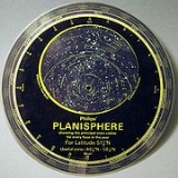
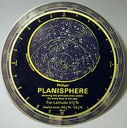
Planisphere
Encyclopedia
Star chart
A star chart is a map of the night sky. Astronomers divide these into grids to use them more easily. They are used to identify and locate astronomical objects such as stars, constellations and galaxies. They have been used for human navigation since time immemorial...
analog computing instrument
Analog computer
An analog computer is a form of computer that uses the continuously-changeable aspects of physical phenomena such as electrical, mechanical, or hydraulic quantities to model the problem being solved...
in the form of two adjustable disks that rotate on a common pivot. It can be adjusted to display the visible stars for any time and date. It is an instrument to assist in learning how to recognize star
Star
A star is a massive, luminous sphere of plasma held together by gravity. At the end of its lifetime, a star can also contain a proportion of degenerate matter. The nearest star to Earth is the Sun, which is the source of most of the energy on Earth...
s and constellations
Constellations
Constellations: An International Journal of Critical and Democratic Theory is a quarterly peer-reviewed academic journal of critical and democratic theory and successor of Praxis International. It is edited by Andrew Arato, Amy Allen, and Andreas Kalyvas...
. The astrolabe
Astrolabe
An astrolabe is an elaborate inclinometer, historically used by astronomers, navigators, and astrologers. Its many uses include locating and predicting the positions of the Sun, Moon, planets, and stars, determining local time given local latitude and longitude, surveying, triangulation, and to...
, an instrument that has its origins in the Hellenistic civilization
Hellenistic civilization
Hellenistic civilization represents the zenith of Greek influence in the ancient world from 323 BCE to about 146 BCE...
, is a predecessor of the modern planisphere.
Summary description
A planisphere consists of a circular star chartStar chart
A star chart is a map of the night sky. Astronomers divide these into grids to use them more easily. They are used to identify and locate astronomical objects such as stars, constellations and galaxies. They have been used for human navigation since time immemorial...
attached at its center to an opaque circular overlay that has a clear elliptical window or hole so that only a portion of the sky map will be visible in the window or hole area at any given time. The chart and overlay are mounted so that they are free to rotate about a common pivot point at their centers. The star chart contains the brightest stars, constellations and (possibly) deep-sky objects visible from a particular latitude on Earth. The night sky that one sees from the Earth depends on whether the observer is in the northern
Northern Hemisphere
The Northern Hemisphere is the half of a planet that is north of its equator—the word hemisphere literally means “half sphere”. It is also that half of the celestial sphere north of the celestial equator...
or southern hemisphere
Southern Hemisphere
The Southern Hemisphere is the part of Earth that lies south of the equator. The word hemisphere literally means 'half ball' or "half sphere"...
s and the latitude. A planisphere window is designed for a particular latitude and will be accurate enough for a certain band either side of that. Planisphere makers will usually offer them in a number of versions for different latitudes. Planispheres only show the stars visible from the observer's latitude
Latitude
In geography, the latitude of a location on the Earth is the angular distance of that location south or north of the Equator. The latitude is an angle, and is usually measured in degrees . The equator has a latitude of 0°, the North pole has a latitude of 90° north , and the South pole has a...
; stars below the horizon are not included.
A complete twenty-four hour time cycle is marked on the rim of the overlay. A full twelve months of calendar
Calendar
A calendar is a system of organizing days for social, religious, commercial, or administrative purposes. This is done by giving names to periods of time, typically days, weeks, months, and years. The name given to each day is known as a date. Periods in a calendar are usually, though not...
dates are marked on the rim of the starchart. The window is marked to show the direction of the eastern and western horizons. The disk and overlay are adjusted so that the observer's local time of day on the overlay corresponds to that day's date on the star chart disc. The portion of the star chart visible in the window then represents (with a distortion because it is a flat surface
Flatness
Flatness may refer to:*Flatness *Flatness *Flatness *Flatness *Flatness , a geometrical tolerance required in certain manufacturing situations*Flatness...
representing a spherical surface
Sphere
A sphere is a perfectly round geometrical object in three-dimensional space, such as the shape of a round ball. Like a circle in two dimensions, a perfect sphere is completely symmetrical around its center, with all points on the surface lying the same distance r from the center point...
) the distribution of stars in the sky at that moment for the planisphere's designed location. Some users hold the planisphere above their head with the eastern and western horizons correctly aligned to easily match up the chart to actual star positions.
History
The word planisphere (or planisferium) means "celestial plane", defined as the flat plane representation of the star-filled sky.The instrument was first described in the early 11th century by the Muslim Persian astronomer
Islamic astronomy
Islamic astronomy or Arabic astronomy comprises the astronomical developments made in the Islamic world, particularly during the Islamic Golden Age , and mostly written in the Arabic language. These developments mostly took place in the Middle East, Central Asia, Al-Andalus, and North Africa, and...
, Abū Rayhān al-Bīrūnī.
The first star chart to have the name "planisphere" was made in 1624 by Jacob Bartsch. Bartsch was the son-in-law of Johannes Kepler
Johannes Kepler
Johannes Kepler was a German mathematician, astronomer and astrologer. A key figure in the 17th century scientific revolution, he is best known for his eponymous laws of planetary motion, codified by later astronomers, based on his works Astronomia nova, Harmonices Mundi, and Epitome of Copernican...
, discoverer of Kepler's laws of planetary motion
Kepler's laws of planetary motion
In astronomy, Kepler's laws give a description of the motion of planets around the Sun.Kepler's laws are:#The orbit of every planet is an ellipse with the Sun at one of the two foci....
.
The star chart
Since the planisphere shows the celestial sphere in a printed flat, there is always considerable distortion. Planispheres, like all charts, are made using a certain projection method. For planispheres there are two major methods in use, leaving the choice with the designer. One such method is the polar azimuthal equidistant projectionAzimuthal equidistant projection
The azimuthal equidistant projection is a type of map projection.A useful application for this type of projection is a polar projection in which all distances measured from the center of the map along any longitudinal line are accurate; an example of a polar azimuthal equidistant projection can be...
. Using this projection the sky is charted centered on one of the celestial poles (polar), while circles of equal declination (for instance 60°, 30°, 0° (the celestial equator), -30°, and -60°) lie equidistant from each other and from the poles (equidistant). The shapes of the constellations are proportionally correct in a straight line from the centre outwards, but at right angles to this direction (parallel to the declination circles) there is considerable distortion. That distortion will be worse as the distance to the pole gets greater. If we study the famous constellation of Orion
Orion (constellation)
Orion, often referred to as The Hunter, is a prominent constellation located on the celestial equator and visible throughout the world. It is one of the most conspicuous, and most recognizable constellations in the night sky...
in this projection and compare this to the real Orion, we can clearly see this distortion. It is the only disadvantage of this projection.
The stereographic projection
Stereographic projection
The stereographic projection, in geometry, is a particular mapping that projects a sphere onto a plane. The projection is defined on the entire sphere, except at one point — the projection point. Where it is defined, the mapping is smooth and bijective. It is conformal, meaning that it...
solves this problem while introducing another. Using this projection the distances between the declination circles are enlarged in such a way that the shapes of the constellations remain correct. Naturally in this projection the constellations on the edge become too large in comparison to constellations near the celestial pole: Orion will be twice as high as it should be! It is the same effect that makes Greenland so huge in Mercator charts. Another disadvantage is that, with more space for constellations near the edge of the planisphere, the space for the constellations around the celestial pole in question will be less than they deserve. For observers at moderate latitudes, who can see the sky near the celestial pole of their hemisphere better than that nearer the horizon, this may be a good reason to prefer a planisphere made with the polar azimuthal equidistant projection method.
The upper disc
The upper disc contains a "horizon", that defines the visible part of the sky at any given moment, which is naturally half of the total starry sky. That horizon line is most of the time also distorted, for the same reason the constellations are distorted. It has become a kind of "collapsed" oval.The horizon is designed for a particular latitude and thus determines the area for which a planisphere is meant. Some more expensive planispheres have several upper discs that can be exchanged, or have an upper disc with more horizon-lines, for different latitudes.
When a planisphere is used in a latitude zone other than the zone for which is was designed, the user will either see stars that are not in the planisphere, or the planisphere will show stars that are not visible in that latitude zone's sky. To study the starry sky thoroughly it may be necessary to buy a planisphere particularly for the area in question.
However, most of the time the part of the sky directly above the horizon will not show many stars, due to hills, woods, buildings or just because of the thickness of the atmosphere we look through. The lower 5° above the horizon in particular hardly shows any stars (let alone objects) except under the very best conditions. Therefore, a planisphere can fairly accurately be used from +5° to -5° of the design latitude. For example, a planisphere for 40° north can be used between 35° and 45° north.
Coordinates
Accurate planispheres somehow represent the celestial coordinates: right ascensionRight ascension
Right ascension is the astronomical term for one of the two coordinates of a point on the celestial sphere when using the equatorial coordinate system. The other coordinate is the declination.-Explanation:...
and declination
Declination
In astronomy, declination is one of the two coordinates of the equatorial coordinate system, the other being either right ascension or hour angle. Declination in astronomy is comparable to geographic latitude, but projected onto the celestial sphere. Declination is measured in degrees north and...
. The changing positions of planets, asteroids or comets in terms of these coordinates can be looked up in annual astronomical guides, and these enable planisphere users to find them in the sky.
Some planispheres use a separate pointer for the declination, using the same pivot point as the upper disc. Some planispheres have a declination feature printed on the upper disc, along the line connecting north and south on the horizon. Right ascension is represented on the edge, where the dates with which to set the planisphere are also found.
External links
- Bartsch, Jacob. Usus Astronomicus Planisphaerii Stellati, 1624. (Scans by Felice Stoppa.) The first cartographic use of the term planisphere.
- National Research Council Canada- Planisphere Downloadable PDF format planisphere for the Northern Hemisphere.
- Southern Star Wheel - customisable southern hemisphere planisphere