
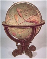
Johannes Schöner globe
Encyclopedia
The Johannes Schöner globe is a globe
developed by Johannes Schöner
(1477-1547), the first being made in 1515. Schöner's globes are some of the oldest globes still in existence. Some of them show areas before they were discovered, such as the Magellan Strait and the Antarctic
.
. The strait is shown at about 40 degrees south
on the 1515 globe.
The Johannes Schöner Globe (1520), a printed globe, was made in 1520. The globe shows the Antarctic continent which had not been explored at that date.
The Johannes Schöner Globe (1523), a printed globe, was made in 1523. It was considered to have been lost until identified by George Nunn in 1927.
The Johannes Schöner's Weimer Globe (1533) was made in 1533. It shows North America as part of Asia and also shows Antarctica.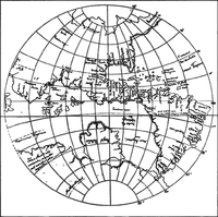
Globe
A globe is a three-dimensional scale model of Earth or other spheroid celestial body such as a planet, star, or moon...
developed by Johannes Schöner
Johannes Schöner
Johannes Schöner was a renowned and respected German polymath...
(1477-1547), the first being made in 1515. Schöner's globes are some of the oldest globes still in existence. Some of them show areas before they were discovered, such as the Magellan Strait and the Antarctic
Antarctic
The Antarctic is the region around the Earth's South Pole, opposite the Arctic region around the North Pole. The Antarctic comprises the continent of Antarctica and the ice shelves, waters and island territories in the Southern Ocean situated south of the Antarctic Convergence...
.
Globes
The Johannes Schöner Globe (1515), a manuscript globe, was made in 1515. The Strait of Magellan can be found on the globe before its "official discovery". The strait is at 53 degrees south53rd parallel south
The 53rd parallel south is a circle of latitude that is 53 degrees south of the Earth's equatorial plane. It crosses the Atlantic Ocean, the Indian Ocean, the Pacific Ocean and South America....
. The strait is shown at about 40 degrees south
40th parallel south
The 40th parallel south is a circle of latitude that is 40 degrees south of the Earth's equatorial plane. It crosses the Atlantic Ocean, the Indian Ocean, Australasia, the Pacific Ocean and South America....
on the 1515 globe.
The Johannes Schöner Globe (1520), a printed globe, was made in 1520. The globe shows the Antarctic continent which had not been explored at that date.
The Johannes Schöner Globe (1523), a printed globe, was made in 1523. It was considered to have been lost until identified by George Nunn in 1927.
The Johannes Schöner's Weimer Globe (1533) was made in 1533. It shows North America as part of Asia and also shows Antarctica.
See also
- Johannes SchönerJohannes SchönerJohannes Schöner was a renowned and respected German polymath...
- ErdapfelErdapfelThe Erdapfel produced by Martin Behaim in 1492 is considered to be the oldest surviving terrestrial globe. It is constructed of a laminated linen ball in two halves, reinforced with wood and overlaid with a map painted by Georg Glockendon....
- Hunt-Lenox GlobeHunt-Lenox GlobeThe Hunt-Lenox Globe or Lenox Globe, dating from ca. 1510, is the second or third oldest known terrestrial globe, after the Erdapfel of 1492. It bears a striking resemblance to the Globus Jagellonicus, also tentatively dated to 1510...
- Globus JagellonicusGlobus JagellonicusThe Globus Jagellonicus or Jagiellonian globe, made in France and dated to around 1510, is by some considered to be the oldest existing globe to show the Americas...
- Ancient world mapsAncient world mapsEarly world maps cover depictions of the world from the Iron Age to the Age of Discovery and the emergence of modern geography during the early modern period.-Babylonian Imago Mundi Early world maps cover depictions of the world from the Iron Age to the Age of Discovery and the emergence of modern...
- World mapWorld mapA world map is a map of the surface of the Earth, which may be made using any of a number of different map projections. A map projection is any method of representing the surface of a sphere or other three-dimensional body on a plane....
- Timeline of pre-Columbian trans-oceanic contactTimeline of pre-Columbian trans-oceanic contactThis is a Timeline of Pre-Columbian trans-oceanic contact, as accepted by mainstream archaeology.*Norse colonization of the Americas:** c.1000: Erik the Red and Leif Ericson, Viking navigators, discovered and settled Greenland, Helluland , Markland and Vinland...
- Pre-Columbian trans-oceanic contactPre-Columbian trans-oceanic contactTheories of Pre-Columbian trans-oceanic contact are those theories that propose interaction between indigenous peoples of the Americas who settled the Americas before 10,000 BC, and peoples of other continents , which occurred before the arrival of Christopher Columbus in the Caribbean in 1492.Many...
- Martin WaldseemüllerMartin WaldseemüllerMartin Waldseemüller was a German cartographer...
External links
- The Johann Schönner globe of the world of 1520 at Nito Verdera's site.