
Theatrum Orbis Terrarum
Encyclopedia
- for Theatrum orbis terrarum, sive, Atlas novus by Blaeu 1635, see Atlas MaiorAtlas MaiorThe Atlas Maior is a comprehensive world atlas, conceived by Willem Blaeu of Amsterdam, but compiled by his son Joan Blaeu, and completed in 1665...

Abraham Ortelius
thumb|250px|Abraham Ortelius by [[Peter Paul Rubens]]Abraham Ortelius thumb|250px|Abraham Ortelius by [[Peter Paul Rubens]]Abraham Ortelius (Abraham Ortels) thumb|250px|Abraham Ortelius by [[Peter Paul Rubens]]Abraham Ortelius (Abraham Ortels) (April 14, 1527 – June 28,exile in England to take...
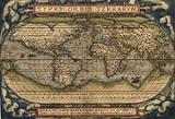
and originally printed on May 20, 1570, in Antwerp, it consisted of a collection of uniform map
Map
A map is a visual representation of an area—a symbolic depiction highlighting relationships between elements of that space such as objects, regions, and themes....
sheets and sustaining text bound to form a book for which copper printing plates were specifically engraved. The Ortelius atlas is sometimes referred to as the summary of sixteenth-century cartography
Cartography
Cartography is the study and practice of making maps. Combining science, aesthetics, and technique, cartography builds on the premise that reality can be modeled in ways that communicate spatial information effectively.The fundamental problems of traditional cartography are to:*Set the map's...
. Many of his atlas' maps were based upon sources that no longer exist or are extremely rare. Ortelius appended a unique source list (the "Catalogus Auctorum") identifying the names of contemporary cartographers, some of whom would otherwise have remained obscure.
After the initial release of Theatrum Orbis Terrarum, Ortelius regularly revised and expanded the atlas, reissuing it in various formats until his death in 1598. From its original seventy maps and eighty-seven bibliographic references in the first edition (1570), the atlas grew through its thirty-one editions to encompass 183 references and 167 maps in 1612.
The 1573 Additamentum to the atlas is notable for containing Humphrey Llwyd's Cambriae Typus
Cambriae Typus
Cambriae Typus, the "model image of Wales", is the earliest published map of Wales as a separate region from the rest of Great Britain. Made by Elizabethan polymath Humphrey Llwyd in 1573, the map shows Wales stretching to the River Severn, including large areas of what is now...
, the first map to show Wales
Wales
Wales is a country that is part of the United Kingdom and the island of Great Britain, bordered by England to its east and the Atlantic Ocean and Irish Sea to its west. It has a population of three million, and a total area of 20,779 km²...
on its own.
Since the 1630s, the Blaeu
Blaeu
Blaeu is the name of* Willem Janszoon Blaeu or Willem Blaeu, Dutch cartographer not to be confused with Willem Janszoon, a contemporary Dutch explorer* his sons Joan Blaeu and Cornelius Blaeu, cartographers...
family issued their work under a similar title, Theatrum orbis terrarum, sive, Atlas Novus
Atlas Maior
The Atlas Maior is a comprehensive world atlas, conceived by Willem Blaeu of Amsterdam, but compiled by his son Joan Blaeu, and completed in 1665...
.
See also
- Maris PacificiMaris PacificiMaris Pacifici is more accurately named the Descriptio Maris Pacifici, Description of the Pacific Sea. It was the first dedicated map of the Pacific to be printed and is considered an important advancement in cartography....
- Ancient world mapsAncient world mapsEarly world maps cover depictions of the world from the Iron Age to the Age of Discovery and the emergence of modern geography during the early modern period.-Babylonian Imago Mundi Early world maps cover depictions of the world from the Iron Age to the Age of Discovery and the emergence of modern...
- History of cartographyHistory of cartographyCartography , or mapmaking, has been an integral part of the human story for a long time, possibly up to 8,000 years...
- List of geographers
- Mappa MundiMappa mundiMappa mundi is a general term used to describe medieval European maps of the world. These maps range in size and complexity from simple schematic maps an inch or less across to elaborate wall maps, the largest of which was 11 ft. in diameter...
- Here be dragonsHere be dragons"Here be dragons" is a phrase used to denote dangerous or unexplored territories, in imitation of the medieval practice of putting sea serpents and other mythological creatures in uncharted areas of maps.-History:...
- Terra incognitaTerra incognitaTerra incognita or terra ignota is a term used in cartography for regions that have not been mapped or documented. The expression is believed to be first seen in Ptolemy’s Geography circa 150 CE...
External links
- Library of Congress, Historical Collections for the National Digital Library, Ortelius Atlas
- High resolution zoomable images from the 1574 edition - Collection item from the State Library of VictoriaState Library of VictoriaThe State Library of Victoria is the central library of the state of Victoria, Australia, located in Melbourne. It is on the block bounded by Swanston, La Trobe, Russell, and Little Lonsdale streets, in the northern centre of the central business district...