

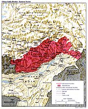
McMahon Line
Encyclopedia
Great Britain
Great Britain or Britain is an island situated to the northwest of Continental Europe. It is the ninth largest island in the world, and the largest European island, as well as the largest of the British Isles...
and Tibet
Tibet
Tibet is a plateau region in Asia, north-east of the Himalayas. It is the traditional homeland of the Tibetan people as well as some other ethnic groups such as Monpas, Qiang, and Lhobas, and is now also inhabited by considerable numbers of Han and Hui people...
as part of Simla Accord, a treaty signed in 1914. Although its legal status is disputed by China, it is the effective boundary between China and India.
The line is named after Sir Henry McMahon, foreign secretary of British India
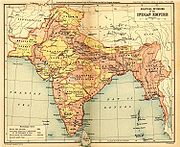
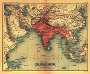
British Raj
British Raj was the British rule in the Indian subcontinent between 1858 and 1947; The term can also refer to the period of dominion...
and the chief negotiator of the convention. It extends for 550 miles (885.1 km) from Bhutan
Bhutan
Bhutan , officially the Kingdom of Bhutan, is a landlocked state in South Asia, located at the eastern end of the Himalayas and bordered to the south, east and west by the Republic of India and to the north by the People's Republic of China...
in the west to 160 miles (257.5 km) east of the great bend of the Brahmaputra River
Brahmaputra River
The Brahmaputra , also called Tsangpo-Brahmaputra, is a trans-boundary river and one of the major rivers of Asia. It is the only Indian river that is attributed the masculine gender and thus referred to as a in Indo-Aryan languages and languages with Indo-Aryan influence...
in the east, largely along the crest of the Himalayas. Simla (along with the McMahon Line) was initially rejected by the British-run Government of India as incompatible with the 1907 Anglo-Russian Convention. This convention was renounced in 1921. After Simla, the McMahon Line was forgotten until 1935, when British civil service officer Olaf Caroe
Olaf Caroe
Sir Olaf Kirkpatrick Kruuse Caroe KCSI KCIE was an administrator in British India. He later became a writer on the Middle East and Asia.-Life:...
convinced the government to publish the Simla Convention and use the McMahon Line on official maps.
The McMahon Line is regarded by India as the legal national border, although previous Indian governments have made claims (and stationed soldiers and outposts) north of the McMahon Line, such as during the Forward Policy period under then Prime Minister Jawaharlal Nehru
Jawaharlal Nehru
Jawaharlal Nehru , often referred to with the epithet of Panditji, was an Indian statesman who became the first Prime Minister of independent India and became noted for his “neutralist” policies in foreign affairs. He was also one of the principal leaders of India’s independence movement in the...
prior to the Sino-Indian War
Sino-Indian War
The Sino-Indian War , also known as the Sino-Indian Border Conflict , was a war between China and India that occurred in 1962. A disputed Himalayan border was the main pretext for war, but other issues played a role. There had been a series of violent border incidents after the 1959 Tibetan...
. The Dalai Lama's Tibetan government-in-exile also accepts the line as an official border.
China rejects the Simla Accord, contending that the Tibetan government was not sovereign and therefore did not have the power to conclude treaties. Chinese maps show some 56000 square miles (145,039.3 km²) of the territory south of the line as part of the Tibet Autonomous Region
Tibet Autonomous Region
The Tibet Autonomous Region , Tibet or Xizang for short, also called the Xizang Autonomous Region is a province-level autonomous region of the People's Republic of China , created in 1965....
, popularly known as South Tibet
South Tibet
The Arunachal Pradesh dispute is a territorial dispute over the region located on the middle of the Yarlung Zangbo River, 300 km north of the Himalayas. It is entirely administered by India as part of its Arunachal Pradesh state; China claims it as a part of its Tibet Autonomous Region and...
in China. Chinese forces briefly occupied this area during the Sino-Indian War
Sino-Indian War
The Sino-Indian War , also known as the Sino-Indian Border Conflict , was a war between China and India that occurred in 1962. A disputed Himalayan border was the main pretext for war, but other issues played a role. There had been a series of violent border incidents after the 1959 Tibetan...
of 1962-63. China does recognize a Line of Actual Control
Line of Actual Control
The Line of Actual Control is the effective border between India and People's Republic of China . The LAC is 4,057-km long and traverses three areas of northern Indian states: western , middle and eastern...
which includes a portion of the "so called McMahon line" in the eastern part of its border with India
India
India , officially the Republic of India , is a country in South Asia. It is the seventh-largest country by geographical area, the second-most populous country with over 1.2 billion people, and the most populous democracy in the world...
, according to a 1959 diplomatic note by Prime Minister Zhou Enlai
Zhou Enlai
Zhou Enlai was the first Premier of the People's Republic of China, serving from October 1949 until his death in January 1976...
.
History
Drawing the line
Early British efforts to create a boundary in this sector were triggered by their discovery in the mid-19th century that Tawang, an important trading town, was Tibetan territory. In 1873, the British-run Government of India drew an "Outer Line," intended as an international boundary. This line follows the alignment of the Himalayan foothills, now roughly the southern boundary of Arunachal Pradesh. Britain concluded treaties with Beijing concerning Tibet's boundaries with Burma and Sikkim. However, Tibet refused to recognize the boundaries drawn by these treaties. British forces led by Sir Francis YounghusbandFrancis Younghusband
Lieutenant Colonel Sir Francis Edward Younghusband, KCSI, KCIE was a British Army officer, explorer, and spiritual writer...
invaded Tibet in 1904 and imposed a treaty on the Tibetans. In 1907, Britain and Russia acknowledged Chinese "suzerainty
Suzerainty
Suzerainty occurs where a region or people is a tributary to a more powerful entity which controls its foreign affairs while allowing the tributary vassal state some limited domestic autonomy. The dominant entity in the suzerainty relationship, or the more powerful entity itself, is called a...
" over Tibet and both nations "engage not to enter into negotiations with Tibet except through the intermediary of the Chinese Government."
British interest in the borderlands was renewed when the Qing government sent military forces to establish Chinese administration in Tibet (1910–12). A British military expedition was sent into what is now Arunachal Pradesh
Arunachal Pradesh
Arunachal Pradesh is a state of India, located in the far northeast. It borders the states of Assam and Nagaland to the south, and shares international borders with Burma in the east, Bhutan in the west, and the People's Republic of China in the north. The majority of the territory is claimed by...
and the North East Frontier Tract was created to administer the area (1912). In 1912-13, this agency reached agreements with the tribal leaders who ruled the bulk of the region. The Outer Line was moved north, but Tawang was left as Tibetan territory. After the fall of the Qing dynasty in China, Tibet expelled all Chinese officials and troops, and declared itself independent (1913).
In 1913, British officials conferred at Simla
Shimla
Shimla , formerly known as Simla, is the capital city of Himachal Pradesh. In 1864, Shimla was declared the summer capital of the British Raj in India. A popular tourist destination, Shimla is often referred to as the "Queen of Hills," a term coined by the British...
, India to discuss Tibet's status. The conference was attended by representatives of Britain, China, and Tibet. "Outer Tibet," covering approximately the same area as the modern "Tibet Autonomous Region
Tibet Autonomous Region
The Tibet Autonomous Region , Tibet or Xizang for short, also called the Xizang Autonomous Region is a province-level autonomous region of the People's Republic of China , created in 1965....
" would be under the administration of the Dalai Lama
Dalai Lama
The Dalai Lama is a high lama in the Gelug or "Yellow Hat" branch of Tibetan Buddhism. The name is a combination of the Mongolian word далай meaning "Ocean" and the Tibetan word bla-ma meaning "teacher"...
's government as well as the "suzerainty" of China. Suzerainty was a colonial concept indicating limited authority over a dependent state. The final 3 July 1914 accord lacked any textual boundary delimitation
Boundary delimitation
Boundary delimitation, or simply delimitation, is the term used to describe the drawing of boundaries, but is most often used to describe the drawing of electoral boundaries, specifically those of precincts, states, counties or other municipalities...
s or descriptions. It made reference to a small scale map with very little detail, one that primarily showed lines separating China from "Inner Tibet" and "Inner Tibet" from "Outer Tibet." This map lacked any initials or signatures from the Chinese plenipotentiary Ivan Chen; however Chen had signed an earlier, similar draft of it from 27 April 1914.
Both drafts of this small scale map extend the identical red line symbol between "Inner Tibet" and China further to the southwest, approximating the entire route of the McMahon Line, and thus dead ending near Tawang at the Bhutan tripoint. However, neither draft labels "British India" or anything similar in the area that now constitutes Arunachal Pradesh
Arunachal Pradesh
Arunachal Pradesh is a state of India, located in the far northeast. It borders the states of Assam and Nagaland to the south, and shares international borders with Burma in the east, Bhutan in the west, and the People's Republic of China in the north. The majority of the territory is claimed by...
.
The far more detailed eight miles to the inch McMahon Line map of 24–25 March 1914 is signed only by the Tibetan and British representatives. This map and McMahon Line negotiations were both done without Chinese participation. After Beijing repudiated Simla, the British and Tibetan delegates attached a note denying China any privileges under the agreement and signed it as a bilateral accord.
Britain attempts to enforce line
Olaf Caroe
Sir Olaf Kirkpatrick Kruuse Caroe KCSI KCIE was an administrator in British India. He later became a writer on the Middle East and Asia.-Life:...
. The Survey of India
Survey of India
The Survey of India is India's central engineering agency in charge of mapping and surveying. Set up in 1767 to help consolidate the territories of the British East India Company, it is one of the oldest Engineering Departments of the Government of India...
published a map showing the McMahon Line as the official boundary in 1937. In 1938, the British published the Simla Accord in Aitchison's Treaties. A volume published earlier was recalled from libraries and replaced with a volume that includes the Simla Accord together with an editor's note stating that Tibet and Britain, but not China, accepted the agreement as binding. The replacement volume has a false 1929 publication date.
When the British demanded that the Tawang monastery, located south of the McMahon Line, cease paying taxes to Lhasa
Lhasa
Lhasa is the administrative capital of the Tibet Autonomous Region in the People's Republic of China and the second most populous city on the Tibetan Plateau, after Xining. At an altitude of , Lhasa is one of the highest cities in the world...
, Tibet protested. However, Lhasa raised no objection to British activity in other sectors of the McMahon Line. In 1944, NEFT established direct administrative control for the entire area it was assigned, although Tibet soon regained authority in Tawang. In 1947, the Tibetan government wrote a note presented to the Indian Ministry of External Affairs laying claim to Tibetan districts south of the McMahon Line. In Beijing, the Communist Party came to power in 1949 and declared its intention to "liberate" Tibet. India, which had become independent in 1947, responded by declaring the McMahon Line to be its boundary and by decisively asserting control of the Tawang area (1950–51).
India and China dispute boundary
In the 1950s, India-China relations were cordial and the boundary dispute quiet. The Indian government under Prime Minister Jawaharlal NehruJawaharlal Nehru
Jawaharlal Nehru , often referred to with the epithet of Panditji, was an Indian statesman who became the first Prime Minister of independent India and became noted for his “neutralist” policies in foreign affairs. He was also one of the principal leaders of India’s independence movement in the...
promoted the slogan Hindi-Chini bhai-bhai. (India and China are brothers). Zhou Enlai
Zhou Enlai
Zhou Enlai was the first Premier of the People's Republic of China, serving from October 1949 until his death in January 1976...
offered to accept the McMahon Line in 1956 , but only in the context of border negotiations as equals, because simply accepting the British boundary would leave the stigma of the unequal treaty and hurt Chinese pride. But Nehru maintained his 1950 statement that he would not accept negotiations if China brought the boundary dispute up, hoping that "China would accept the fait accompli. In 1954, India renamed the disputed area the North East Frontier Agency.
India acknowledged that Tibet was a part of China and gave up its extraterritorial rights in Tibet inherited from the British in a treaty concluded in April 1954
Five Principles of Peaceful Coexistence
The Five Principles of Peaceful Coexistence, known in India as the Panchsheel, are a set of principles to govern relations between states. Their first formal codification in treaty form was in an agreement between by China and India in 1954...
. Nehru later claimed that because China did not bring up the border issue at the 1954 conference, the issue was settled. But the only border India had delineated before the conference was the McMahon Line. Several months after the conference, Nehru ordered maps of India published that showed expansive Indian territorial claims as definite boundaries, notably in Aksai Chin
Aksai Chin
Aksai Chin is one of the two main disputed border areas between China and India, and the other is South Tibet, which comprises most of India's Arunachal Pradesh. It is administered by China as part of Hotan County in the Hotan Prefecture of Xinjiang Autonomous Region, but is also claimed by India...
. In the NEFA sector, the new maps gave the hill crest as the boundary, although in some places this line is slightly north of the McMahon Line.
The failure of the 1959 Tibetan uprising
1959 Tibetan uprising
The 1959 Tibetan uprising, or 1959 Tibetan Rebellion began on 10 March 1959, when a revolt erupted in Lhasa, the capital of Tibet, which had been under the effective control of the Communist Party of China since the Seventeen Point Agreement in 1951...
and the 14th Dalai Lama
14th Dalai Lama
The 14th Dalai Lama is the 14th and current Dalai Lama. Dalai Lamas are the most influential figures in the Gelugpa lineage of Tibetan Buddhism, although the 14th has consolidated control over the other lineages in recent years...
's arrival in India in March led Indian parliamentarians to censure Nehru for not securing a commitment from China to respect the McMahon Line. Additionally, the Indian press
Print media in India
Indian print media is one of the largest print media in the world. The history of it started in 1780, with the publication of the Bengal Gazette from Calcutta.-History:...
started openly advocating Tibetan independence. Nehru, seeking to quickly assert sovereignty in response, established "as many military posts along the frontier as possible", unannounced and against the advice of his staff. On discovering the posts, and already suspicious from the ruminations of the Indian press, Chinese leaders began to suspect that Nehru had designs on the region. In August 1959, Chinese troops captured an Indian outpost at Longju, three miles south of the McMahon Line according to the Geonames database (National Geospatial-Intelligence Agency
National Geospatial-Intelligence Agency
The National Geospatial-Intelligence Agency is an agency of the federal government of the United States with the primary mission of collecting, analyzing and distributing geospatial intelligence in support of national security. NGA was formerly known as the National Imagery and Mapping Agency ...
). In a letter to Nehru dated 24 October 1959, Zhou Enlai
Zhou Enlai
Zhou Enlai was the first Premier of the People's Republic of China, serving from October 1949 until his death in January 1976...
proposed that India and China each withdraw their forces 20 kilometers from the line of actual control
Line of Actual Control
The Line of Actual Control is the effective border between India and People's Republic of China . The LAC is 4,057-km long and traverses three areas of northern Indian states: western , middle and eastern...
. Shortly afterward, Zhou defined this line as "the so-called McMahon Line in the east and the line up to which each side exercises actual control in the west".
In November 1961, Nehru formally adopted the "Forward Policy" of setting up military outposts in disputed areas, including 43 outposts north of Zhou's LAC. Chinese leader Mao Zedong
Mao Zedong
Mao Zedong, also transliterated as Mao Tse-tung , and commonly referred to as Chairman Mao , was a Chinese Communist revolutionary, guerrilla warfare strategist, Marxist political philosopher, and leader of the Chinese Revolution...
, at this time weakened by the failure of the Great Leap Forward
Great Leap Forward
The Great Leap Forward of the People's Republic of China was an economic and social campaign of the Communist Party of China , reflected in planning decisions from 1958 to 1961, which aimed to use China's vast population to rapidly transform the country from an agrarian economy into a modern...
, saw war as a means of reasserting his authority. On 8 September 1962, a Chinese unit attacked an Indian post at Dhola on the Thagla Ridge, three kilometers north of the McMahon Line. On 20 October China launched a major attack across the McMahon Line as well as another attack further north. The Sino-Indian War
Sino-Indian War
The Sino-Indian War , also known as the Sino-Indian Border Conflict , was a war between China and India that occurred in 1962. A disputed Himalayan border was the main pretext for war, but other issues played a role. There had been a series of violent border incidents after the 1959 Tibetan...
which followed was a national humiliation for India, with China quickly advancing 90 km (56 mi) from the McMahon Line to Rupa and then Chaku (65 km southeast of Tawang) in NEPA's extreme western portion, and in the NEFA's extreme eastern tip advancing 30 km (19 mi) to Walong. The Soviet Union, United States and Great Britain pledged military aid to India. China then withdrew to the McMahon Line and repatriated the Indian prisoners of war (1963).
NEFA was renamed Arunachal Pradesh
Arunachal Pradesh
Arunachal Pradesh is a state of India, located in the far northeast. It borders the states of Assam and Nagaland to the south, and shares international borders with Burma in the east, Bhutan in the west, and the People's Republic of China in the north. The majority of the territory is claimed by...
in 1972—Chinese maps refer to the area as South Tibet
South Tibet
The Arunachal Pradesh dispute is a territorial dispute over the region located on the middle of the Yarlung Zangbo River, 300 km north of the Himalayas. It is entirely administered by India as part of its Arunachal Pradesh state; China claims it as a part of its Tibet Autonomous Region and...
. In 1981, Chinese leader Deng Xiaoping
Deng Xiaoping
Deng Xiaoping was a Chinese politician, statesman, and diplomat. As leader of the Communist Party of China, Deng was a reformer who led China towards a market economy...
offered India a "package settlement" of the border issue. Eight rounds of talks followed, but there was no agreement.
In 1984, India Intelligence Bureau personnel in the Tawang region set up an observation post in the Sumdorong Chu Valley just south of the highest hill crest, but a few kilometers north of the McMahon Line (the straight line portion extending east from Bhutan for 30 miles). The IB left the area before winter. In 1986, China deployed troops in the valley before an Indian team arrived. This information created a national uproar when it was revealed to the Indian public. In October 1986, Deng threatened to "teach India a lesson". The Indian Army
Indian Army
The Indian Army is the land based branch and the largest component of the Indian Armed Forces. With about 1,100,000 soldiers in active service and about 1,150,000 reserve troops, the Indian Army is the world's largest standing volunteer army...
airlifted a task force to the valley. The confrontation was defused in May 1987 though, as clearly visible on Google Earth, both armies have remained and recent construction of roads and facilities are visible.
The Indian Prime Minister Rajiv Gandhi
Rajiv Gandhi
Rajiv Ratna Gandhi was the sixth Prime Minister of India . He took office after his mother's assassination on 31 October 1984; he himself was assassinated on 21 May 1991. He became the youngest Prime Minister of India when he took office at the age of 40.Rajiv Gandhi was the elder son of Indira...
visited China in 1988 and agreed to a joint working group on boundary issues which has made little apparent positive progress. A 1993 Sino-Indian agreement set up a group to define the LAC; this group has likewise made no progress. A 1996 Sino-Indian agreement set up "confidence-building measures" to avoid border clashes. Although there have been frequent incidents where one state has charged the other with incursions, causing tense encounters along the McMahon Line following India's nuclear test in 1998 and continuing to the present, both sides generally attribute these to disagreements of less than a kilometer as to the exact location of the LAC.
Britain revises position on Tibet
Until 2008, the British Government's position was that China held suzerainty over Tibet but not full sovereignty, as specified in the Simla AccordSimla Accord
Simla Accord can refer to*Simla Accord , signed in 1914, to purported to settle a dispute over the boundary line between inner and outer Tibet....
. It was the only state still to hold this view. Britain revised this view on 29 October 2008, when it recognised Chinese sovereignty over Tibet by issuing a statement on the Foreign Office's website. The Economist
The Economist
The Economist is an English-language weekly news and international affairs publication owned by The Economist Newspaper Ltd. and edited in offices in the City of Westminster, London, England. Continuous publication began under founder James Wilson in September 1843...
stated that although the British Foreign Office's website does not use the word sovereignty, officials at the Foreign Office said "it means that, as far as Britain is concerned, 'Tibet is part of China. Full stop.'"
Further reading
- Why China is playing hardball in Arunachal by Venkatesan Vembu, Daily News & Analysis, May 13, 2007
- China, India, and the fruits of Nehru's folly by Venkatesan Vembu, Daily News & Analysis, June 6, 2007