

Salween River
Encyclopedia
The Salween is a river
, about 2815 kilometres (1,749.2 mi) long, that flows from the Tibetan Plateau
into the Andaman Sea
in Southeast Asia
. It drains a narrow and mountainous watershed of 324000 square kilometre that extends into the countries China
, Burma and Thailand
. Steep canyon walls line the swift, powerful and undammed
Salween, one of the longest free-flowing rivers in the world. Its extensive drainage basin supports a biodiversity comparable with the Mekong
and is home to about 7 million people.
The first people to live on the Salween arrived in the region thousands of years ago, and are still relatively isolated from the rest of the world. The river is only navigable up to 90 kilometres (55.9 mi) from the mouth, and only in the rainy season. In the 1930s, controversy over a trade route between China and Burma that crossed the river sparked the Salween Campaign of World War II
, when thousands of Chinese and Japanese soldiers lost their lives on the river. Logging
began on the mountains surrounding the Salween in the late 20th century, and has damaged the river's ecology. Recently, a number of dam
s were planned to be built on the Salween in China, but because of fierce opposition, the proposals remained undecided for several years, however recent reports from China suggest the dams now will be built.
, near the headwaters of the Mekong
and Yangtze rivers. It initially flows west but then very shortly makes a great bend to the east, entering the Chinese province of Yunnan
and the Three Parallel Rivers of Yunnan Protected Area, a World Heritage Site
. Here, the Salween—called the Nu or Nujiang—has been proposed for a series of enormous dam
s that would theoretically generate more power than Three Gorges Dam
, currently the world's largest hydroelectric station. It then makes a wide southward arc between the Tibetan and Yunnan-Guizhou Plateaus, dropping into what is often known as the "Grand Canyon of the East" or "China's Grand Canyon", a 4000 metres (13,123.4 ft)-deep gorge that takes it past the Chinese border into northeastern Burma through Shan State
and Kayah State
,
 A sharp bend west and another south takes the Salween between Shan Plateau
and Arakan Yoma
, two of the three great mountain ranges of eastern Burma, to join the Moei River
from the east as it approaches Thailand
, where it is called the Salawin. Forming the Burma-Thailand boundary for about 120 kilometres (74.6 mi), the river receives Pai River
also from the left and flows through Salawin National Park
before re-entering Burma, passing through Karen State and Mon State
. The river finally breaks out of its gorge about 250 kilometres (155.3 mi) from the mouth, and slows down dramatically as it courses through a series of agricultural valleys. About 89 kilometres (55.3 mi) from the mouth the river finally widens and deepens enough to become navigable for large watercraft. In quick succession it receives Dontham River from the right and Gyaing River
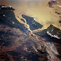
from the left, from where the river turns west, flowing under Thanlwin Bridge and widening into a small river delta
at Mawlamyaing (formerly Moeimein). This region is the most heavily developed on the river and contains most of the basin's population.
Near the mouth the river has an average annual discharge of 1659 m3/s, although this varies widely. The river's base flow
is provided by Tibetan glaciers, although it swells dramatically by the time it reaches the lowlands near the coast, especially in monsoon
season.
. It is approximately 324000 square kilometre large, spreading across three countries and four Burmese states. For much of its length, the Salween's course is nearly parallel to that of the much larger Mekong
in the east. Although the commonly accepted name is Salween, the river is known by a handful of other names regionally: Nu in China, Thanlwin in southern Burma, and Salawin on the border of Thailand and Burma.
Several major sub-continental drainage basins border on the Salween. The Mekong basin forms nearly the entire eastern boundary of the watershed, while the Irrawaddy River flows southwards on the west side of the basin. The smallest boundary is formed by the Yangtze to the extreme north. These three rivers bound nearly 80 percent of the Salween basin, but there are other smaller drainage areas to the southeast and southwest, some emptying into the Andaman Sea/Indian Ocean
and some into the Gulf of Thailand
.
n subcontinent and mainland Asia. When India collided with Asia approximately 50 million years ago, many geographical features in the region were forced upwards to enormous heights, forming such landmarks as the Himalayas
, Qinghai Shan, the Tibetan Plateau, and the eastern Burma massif. To date, India has pushed the boundary of the original Asian continent nearly 2000 kilometres (1,242.7 mi) northwards. Evidence suggests that the southern Tibetan Plateau saw uplift as recently as 15-10 million years ago. The orogenic belt generally trends east to west near the northern part of the Subcontinent and makes a southward arc along with the Salween River on the eastern side. The upper course of the Salween flows through a region dominated by marine
sedimentary rock that originally lay at the bottom of the Indian Ocean
. This rock was uplifted to a height of thousands of metres by the India-Asia orogeny and is rapidly being eroded away by the Salween. Fault lines are strewn throughout the Salween basin, also generally following the pattern of the mountains and river.
(although only 48 to 75 are proved to exist in the river), 7,000 species of plants, and 80 endangered species. Many of the species are endemic to the Salween and the river also has one of the most diverse ranges of turtle
s, with between 10 and 15 species catalogued. The Three Parallel Rivers of Yunnan Protected Areas
in the upper third of the river's course alone has 6,000 plant species. The Salween, the upper basin especially, is so diverse that it has up to 25% of the world's animal species and 50% in China alone. According to UNESCO
, the upper regions of the Salween in China, where it runs parallel to the Mekong
and Yangtze rivers, "may be the most biologically diverse temperate ecosystem in the world".
, Nu
, Lisu, Shan, Karenni
, Wa, Tai, Mon
, and Yintailai. The river has served as the only connection between villages in the region for thousands of years. Although unnavigable by larger craft such as barges or ferries, the river was widely used for transportation by small boats, because the rugged surrounding terrain had no major roads or paths. The southern part of the river has often been the setting of conflicts between the Burmese and Thai over political issues. The majority of the population living on the river has always been very poor, even in poverty
, and the region remains largely agricultural.
The river canyon was the scene of the successful Salween Campaign in World War II
, a battle fought by the Chinese against Japan
in 1944–1945 in order to open up the blockaded Burma Road
supply route from India
, in combination with a second campaign to remove Japanese forces from northern Burma. During the war, this important route was the primary artery along which supplies travelled into Yunnan and then into the heart of China.
The Campaign involved Chinese troops, assisted by American
forces, crossing the upper Salween on 11 May 1944 in order to drive Japanese forces from Yunnan into northern Burma. On 11 May, about 40,000 Chinese of the Chinese Expeditionary Force crossed the Salween initially and a further 60,000 arrived later. About 17,000–19,000 Chinese and 15,000 Japanese were killed in the resulting battle. Tthe higher number of Chinese casualties was caused by the fact that the Japanese had time to prepare their fortifications on the south side of the river. The Chinese continued to take towns and cities on the river back from Japan throughout 1945.
World War II also marked the first time the Salween was used as a national border, as Burma ceded the lands of Shan State
east of the Salween to Thailand, causing the river to become the national border for 120 kilometres (74.6 mi).
Many of the natural resources in the Salween basin remained unexploited until the twentieth century as well. Prior to extensive logging
activity in the upper watershed, the Salween's flow varied much less between the rainy and dry seasons, allowing for fertile riverbanks fed by soil deposits from the river. With the clear-cutting of the forests during the 20th century, specifically in 1997, soil began to erode away in great amounts and was unable to hold water, thus lowering the river's baseflow
during the dry season and causing floods of greater size during the monsoon. The erosion has also made the Salween very silty. The construction of logging roads made it even easier for Burmese interests to enter the area, exploiting other resources and severely damaging the native way of life. Although strict limitations have been imposed on logging, illegal practices continue, including one in 2009 involving the discovery of teak
logs floating in the river on the Thailand-Burma border.
 Since the 1970s, the countries along the river, especially China, have been pressing to build a series of hydroelectric and irrigation
dams on the Salween River, some of which would be among the largest in the world if constructed. The dams were proposed to generate more electricity for the growing population of China, help improve the power supply in surrounding regions of South Asia, and to divert water to irrigation in Thailand and Burma.
China has proposed 13 dams on the Salween through Yunnan, some of which lie within the Three Parallel Rivers World Heritage Site. The Thai and Burma governments are planning to build several more dams. One is said to be larger than the widely controversial Three Gorges Dam
. On April 5, 2006 the Thai and Burma governments signed a $6 billion USD agreement to build the Ta Sang dam. Another Thai-Burma project is for the Hatgyi Dam. A feasibility survey was started in May 2006, but was abandoned until sometime in 2007, due to a military offensive by the State Peace and Development Council
against Karen people
in the area. The dam's builder, the Electricity Generating Authority of Thailand
, had hoped to have the feasibility study completed by April 2006, with construction to start in November 2007.
However, a series of problems have been associated with dams on the Salween. The Salween is one of the longest free flowing rivers in South Asia and is one of only two major free-flowing rivers in China. The river supports thousands of species of plants and animals and is vital to the livelihoods of the many native cultures that live alongside it. It provides water for approximately 7-10 million people and supplies irrigation water to low-lying rice paddies abutting the Andaman Sea. Creating dams on the Salween would involve flooding hundreds of villages and towns and the reduced flow on the lower Salween would cause seawater
to infiltrate inland, making the lower Salween valley unsuitable for growing crops. One of the largest problems is also that the dams would not have much positive impact on the people that actually live in the Salween region. There is controversy over the representation of local opinion in the media. Investigative journalist Liu Jianqiang found little support for the dam projects among locals, who feared they would not get adequate compensation.
The damming has even been regarded as a "military thrust against" the native people, specifically the Karen people.
Because of poor logging
practices in the upstream watershed, the historically silt
y Salween has become many times as turbid as its natural state. A reservoir on the Salween would fill much faster than projected, reducing the overall lifespan of dam projects. There have been many public outcries to damming the Salween, ranging from petitioning to large-scale protests. The Chinese Ministry of the Environment also opposes the dams. After numerous protests, the Chinese government announced it would reduce the 13-dam project to 4 dams, but controversy continues.
— its largest tributary,— the Nam Hsim River, Me Sili River, and Me Sala River; the Nam Hang River, Nam Pan River, Nam Teng River, Nam Pawn River, the Thaung-yin River and the Yonzalin River.
River
A river is a natural watercourse, usually freshwater, flowing towards an ocean, a lake, a sea, or another river. In a few cases, a river simply flows into the ground or dries up completely before reaching another body of water. Small rivers may also be called by several other names, including...
, about 2815 kilometres (1,749.2 mi) long, that flows from the Tibetan Plateau
Tibetan Plateau
The Tibetan Plateau , also known as the Qinghai–Tibetan Plateau is a vast, elevated plateau in Central Asia covering most of the Tibet Autonomous Region and Qinghai, in addition to smaller portions of western Sichuan, southwestern Gansu, and northern Yunnan in Western China and Ladakh in...
into the Andaman Sea
Andaman Sea
The Andaman Sea or Burma Sea is a body of water to the southeast of the Bay of Bengal, south of Burma, west of Thailand and east of the Andaman Islands, India; it is part of the Indian Ocean....
in Southeast Asia
Southeast Asia
Southeast Asia, South-East Asia, South East Asia or Southeastern Asia is a subregion of Asia, consisting of the countries that are geographically south of China, east of India, west of New Guinea and north of Australia. The region lies on the intersection of geological plates, with heavy seismic...
. It drains a narrow and mountainous watershed of 324000 square kilometre that extends into the countries China
China
Chinese civilization may refer to:* China for more general discussion of the country.* Chinese culture* Greater China, the transnational community of ethnic Chinese.* History of China* Sinosphere, the area historically affected by Chinese culture...
, Burma and Thailand
Thailand
Thailand , officially the Kingdom of Thailand , formerly known as Siam , is a country located at the centre of the Indochina peninsula and Southeast Asia. It is bordered to the north by Burma and Laos, to the east by Laos and Cambodia, to the south by the Gulf of Thailand and Malaysia, and to the...
. Steep canyon walls line the swift, powerful and undammed
Dam
A dam is a barrier that impounds water or underground streams. Dams generally serve the primary purpose of retaining water, while other structures such as floodgates or levees are used to manage or prevent water flow into specific land regions. Hydropower and pumped-storage hydroelectricity are...
Salween, one of the longest free-flowing rivers in the world. Its extensive drainage basin supports a biodiversity comparable with the Mekong
Mekong
The Mekong is a river that runs through China, Burma, Laos, Thailand, Cambodia and Vietnam. It is the world's 10th-longest river and the 7th-longest in Asia. Its estimated length is , and it drains an area of , discharging of water annually....
and is home to about 7 million people.
The first people to live on the Salween arrived in the region thousands of years ago, and are still relatively isolated from the rest of the world. The river is only navigable up to 90 kilometres (55.9 mi) from the mouth, and only in the rainy season. In the 1930s, controversy over a trade route between China and Burma that crossed the river sparked the Salween Campaign of World War II
World War II
World War II, or the Second World War , was a global conflict lasting from 1939 to 1945, involving most of the world's nations—including all of the great powers—eventually forming two opposing military alliances: the Allies and the Axis...
, when thousands of Chinese and Japanese soldiers lost their lives on the river. Logging
Logging
Logging is the cutting, skidding, on-site processing, and loading of trees or logs onto trucks.In forestry, the term logging is sometimes used in a narrow sense concerning the logistics of moving wood from the stump to somewhere outside the forest, usually a sawmill or a lumber yard...
began on the mountains surrounding the Salween in the late 20th century, and has damaged the river's ecology. Recently, a number of dam
Dam
A dam is a barrier that impounds water or underground streams. Dams generally serve the primary purpose of retaining water, while other structures such as floodgates or levees are used to manage or prevent water flow into specific land regions. Hydropower and pumped-storage hydroelectricity are...
s were planned to be built on the Salween in China, but because of fierce opposition, the proposals remained undecided for several years, however recent reports from China suggest the dams now will be built.
Geography
The Salween rises at 1578 metres (5,177.2 ft) in the Qinghai Mountains on the Tibetan PlateauTibetan Plateau
The Tibetan Plateau , also known as the Qinghai–Tibetan Plateau is a vast, elevated plateau in Central Asia covering most of the Tibet Autonomous Region and Qinghai, in addition to smaller portions of western Sichuan, southwestern Gansu, and northern Yunnan in Western China and Ladakh in...
, near the headwaters of the Mekong
Mekong
The Mekong is a river that runs through China, Burma, Laos, Thailand, Cambodia and Vietnam. It is the world's 10th-longest river and the 7th-longest in Asia. Its estimated length is , and it drains an area of , discharging of water annually....
and Yangtze rivers. It initially flows west but then very shortly makes a great bend to the east, entering the Chinese province of Yunnan
Yunnan
Yunnan is a province of the People's Republic of China, located in the far southwest of the country spanning approximately and with a population of 45.7 million . The capital of the province is Kunming. The province borders Burma, Laos, and Vietnam.Yunnan is situated in a mountainous area, with...
and the Three Parallel Rivers of Yunnan Protected Area, a World Heritage Site
World Heritage Site
A UNESCO World Heritage Site is a place that is listed by the UNESCO as of special cultural or physical significance...
. Here, the Salween—called the Nu or Nujiang—has been proposed for a series of enormous dam
Dam
A dam is a barrier that impounds water or underground streams. Dams generally serve the primary purpose of retaining water, while other structures such as floodgates or levees are used to manage or prevent water flow into specific land regions. Hydropower and pumped-storage hydroelectricity are...
s that would theoretically generate more power than Three Gorges Dam
Three Gorges Dam
The Three Gorges Dam is a hydroelectric dam that spans the Yangtze River by the town of Sandouping, located in the Yiling District of Yichang, in Hubei province, China...
, currently the world's largest hydroelectric station. It then makes a wide southward arc between the Tibetan and Yunnan-Guizhou Plateaus, dropping into what is often known as the "Grand Canyon of the East" or "China's Grand Canyon", a 4000 metres (13,123.4 ft)-deep gorge that takes it past the Chinese border into northeastern Burma through Shan State
Shan State
Shan State is a state of Burma . Shan State borders China to the north, Laos to the east, and Thailand to the south, and five administrative divisions of Burma in the west. Largest of the 14 administrative divisions by land area, Shan State covers 155,800 km², almost a quarter of the total...
and Kayah State
Kayah State
Kayah State is a state of Myanmar. Situated in eastern Myanmar, it is bounded on the north by Shan State, on the east by Thailand's Mae Hong Son Province, and on the south and west by Kayin State. It lies approximately between 18° 30' and 19° 55' north latitude and between 94°40' and 97° 93' east...
,
Shan Plateau
The Shan Plateau, in the Shan State of eastern Burma, is the primary source of the nation's sapphires, rubies and other gems for which Burma is famous. The plateau averages about 3,000 feet in elevation, and is sparsely populated. The Salween River runs through the region, which is also a principal...
and Arakan Yoma
Arakan Yoma
The Arakan Mountains is a mountain range in western Burma , between the coast of Rakhine State and the Central Burma Basin, in which flows the Irrawaddy River...
, two of the three great mountain ranges of eastern Burma, to join the Moei River
Moei River
The Moei River is a tributary of the Salween River. It originates in Phop Phra district, Tak Province. Unlike most rivers in Thailand, it flows north. The river forms the natural border line between Thailand and Burma...
from the east as it approaches Thailand
Thailand
Thailand , officially the Kingdom of Thailand , formerly known as Siam , is a country located at the centre of the Indochina peninsula and Southeast Asia. It is bordered to the north by Burma and Laos, to the east by Laos and Cambodia, to the south by the Gulf of Thailand and Malaysia, and to the...
, where it is called the Salawin. Forming the Burma-Thailand boundary for about 120 kilometres (74.6 mi), the river receives Pai River
Pai River
The Pai River originates in mountainous Pai, Mae Hong Son Province. The river flows down to Mueang Mae Hong Son district. The river tributes the Salween River in Kayah State, Myanmar. It is 180 km long. Located close to the Myanmar border, the Pai river offers several rafting options. The...
also from the left and flows through Salawin National Park
Salawin National Park
The Salawin National Park is located in Mae Sariang and Sop Moei Districts in Mae Hong Son Province, northern Thailand, adjacent to its border with Burma. Much of the Salween River is included in the park. The terrain is mountainous jungle and rocky river...
before re-entering Burma, passing through Karen State and Mon State
Mon State
Mon State is an administrative division of Myanmar. It is sandwiched between Kayin State on the east, the Andaman Sea on the west, Bago Region on the north and Tanintharyi Region on the south, and has a short border with Thailand's Kanchanaburi Province at its south-eastern tip. The land area is...
. The river finally breaks out of its gorge about 250 kilometres (155.3 mi) from the mouth, and slows down dramatically as it courses through a series of agricultural valleys. About 89 kilometres (55.3 mi) from the mouth the river finally widens and deepens enough to become navigable for large watercraft. In quick succession it receives Dontham River from the right and Gyaing River
Gyaing River
Gyaing River) is a river of Kayin State and Mon State, in southeastern Burma . Its two major tributaries, the Hlaingbwe River and the Haungtharaw River, flow together to form the Gyaing at . It is about 45 miles long and flows into the Salween River immediately above Moulmein, at .The Gyaing is a...
from the left, from where the river turns west, flowing under Thanlwin Bridge and widening into a small river delta
River delta
A delta is a landform that is formed at the mouth of a river where that river flows into an ocean, sea, estuary, lake, reservoir, flat arid area, or another river. Deltas are formed from the deposition of the sediment carried by the river as the flow leaves the mouth of the river...
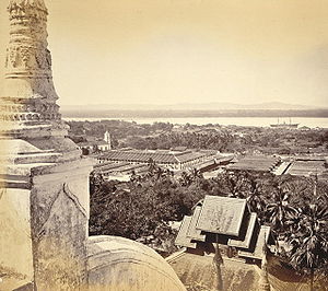
at Mawlamyaing (formerly Moeimein). This region is the most heavily developed on the river and contains most of the basin's population.
Near the mouth the river has an average annual discharge of 1659 m3/s, although this varies widely. The river's base flow
Base flow
The term base flow may refer to* Baseflow in hydrology;* Base flow in the study of random dynamical systems in mathematics....
is provided by Tibetan glaciers, although it swells dramatically by the time it reaches the lowlands near the coast, especially in monsoon
Monsoon
Monsoon is traditionally defined as a seasonal reversing wind accompanied by corresponding changes in precipitation, but is now used to describe seasonal changes in atmospheric circulation and precipitation associated with the asymmetric heating of land and sea...
season.
Basin
The Salween basin is one of the largest in Southeast AsiaSoutheast Asia
Southeast Asia, South-East Asia, South East Asia or Southeastern Asia is a subregion of Asia, consisting of the countries that are geographically south of China, east of India, west of New Guinea and north of Australia. The region lies on the intersection of geological plates, with heavy seismic...
. It is approximately 324000 square kilometre large, spreading across three countries and four Burmese states. For much of its length, the Salween's course is nearly parallel to that of the much larger Mekong
Mekong
The Mekong is a river that runs through China, Burma, Laos, Thailand, Cambodia and Vietnam. It is the world's 10th-longest river and the 7th-longest in Asia. Its estimated length is , and it drains an area of , discharging of water annually....
in the east. Although the commonly accepted name is Salween, the river is known by a handful of other names regionally: Nu in China, Thanlwin in southern Burma, and Salawin on the border of Thailand and Burma.
Several major sub-continental drainage basins border on the Salween. The Mekong basin forms nearly the entire eastern boundary of the watershed, while the Irrawaddy River flows southwards on the west side of the basin. The smallest boundary is formed by the Yangtze to the extreme north. These three rivers bound nearly 80 percent of the Salween basin, but there are other smaller drainage areas to the southeast and southwest, some emptying into the Andaman Sea/Indian Ocean
Indian Ocean
The Indian Ocean is the third largest of the world's oceanic divisions, covering approximately 20% of the water on the Earth's surface. It is bounded on the north by the Indian Subcontinent and Arabian Peninsula ; on the west by eastern Africa; on the east by Indochina, the Sunda Islands, and...
and some into the Gulf of Thailand
Gulf of Thailand
The Gulf of Thailand , also known in to Malays as Teluk Siam literally meant Gulf of Siam, is a shallow arm of the South China Sea.-Geography:...
.
Geology
Much of the watershed consists of one canyon generally paralleling the crustal convergence of the IndiaIndia
India , officially the Republic of India , is a country in South Asia. It is the seventh-largest country by geographical area, the second-most populous country with over 1.2 billion people, and the most populous democracy in the world...
n subcontinent and mainland Asia. When India collided with Asia approximately 50 million years ago, many geographical features in the region were forced upwards to enormous heights, forming such landmarks as the Himalayas
Himalayas
The Himalaya Range or Himalaya Mountains Sanskrit: Devanagari: हिमालय, literally "abode of snow"), usually called the Himalayas or Himalaya for short, is a mountain range in Asia, separating the Indian subcontinent from the Tibetan Plateau...
, Qinghai Shan, the Tibetan Plateau, and the eastern Burma massif. To date, India has pushed the boundary of the original Asian continent nearly 2000 kilometres (1,242.7 mi) northwards. Evidence suggests that the southern Tibetan Plateau saw uplift as recently as 15-10 million years ago. The orogenic belt generally trends east to west near the northern part of the Subcontinent and makes a southward arc along with the Salween River on the eastern side. The upper course of the Salween flows through a region dominated by marine
Marine (ocean)
Marine is an umbrella term. As an adjective it is usually applicable to things relating to the sea or ocean, such as marine biology, marine ecology and marine geology...
sedimentary rock that originally lay at the bottom of the Indian Ocean
Indian Ocean
The Indian Ocean is the third largest of the world's oceanic divisions, covering approximately 20% of the water on the Earth's surface. It is bounded on the north by the Indian Subcontinent and Arabian Peninsula ; on the west by eastern Africa; on the east by Indochina, the Sunda Islands, and...
. This rock was uplifted to a height of thousands of metres by the India-Asia orogeny and is rapidly being eroded away by the Salween. Fault lines are strewn throughout the Salween basin, also generally following the pattern of the mountains and river.
Natural history
One of the most diverse ecoregions in the world is supported by the Salween drainage basin. The river supports up 140 species of fishFish
Fish are a paraphyletic group of organisms that consist of all gill-bearing aquatic vertebrate animals that lack limbs with digits. Included in this definition are the living hagfish, lampreys, and cartilaginous and bony fish, as well as various extinct related groups...
(although only 48 to 75 are proved to exist in the river), 7,000 species of plants, and 80 endangered species. Many of the species are endemic to the Salween and the river also has one of the most diverse ranges of turtle
Turtle
Turtles are reptiles of the order Testudines , characterised by a special bony or cartilaginous shell developed from their ribs that acts as a shield...
s, with between 10 and 15 species catalogued. The Three Parallel Rivers of Yunnan Protected Areas
Three Parallel Rivers of Yunnan Protected Areas
The Three Parallel Rivers of Yunnan Protected Areas is a UNESCO World Heritage Site in Yunnan province, China.It lies within the drainage basins of the upper reaches of the Yangtze , Mekong and Salween rivers, in the Yunnanese section of the Hengduan Mountains.-Overview:-Geography:The protected...
in the upper third of the river's course alone has 6,000 plant species. The Salween, the upper basin especially, is so diverse that it has up to 25% of the world's animal species and 50% in China alone. According to UNESCO
UNESCO
The United Nations Educational, Scientific and Cultural Organization is a specialized agency of the United Nations...
, the upper regions of the Salween in China, where it runs parallel to the Mekong
Mekong
The Mekong is a river that runs through China, Burma, Laos, Thailand, Cambodia and Vietnam. It is the world's 10th-longest river and the 7th-longest in Asia. Its estimated length is , and it drains an area of , discharging of water annually....
and Yangtze rivers, "may be the most biologically diverse temperate ecosystem in the world".
History
Indigenous people that lived on the river include KarenKaren people
The Karen or Kayin people , are a Sino-Tibetan language speaking ethnic group which resides primarily in southern and southeastern Burma . The Karen make up approximately 7 percent of the total Burmese population of approximately 50 million people...
, Nu
Nu people
The Nu people are one of the 56 ethnic groups recognized by the People's Republic of China. Their population of 27,000 is divided into the Northern, Central and Southern groups. Their homeland is a country of high mountains and deep ravines crossed by the Lancang, Dulong and Nujiang rivers...
, Lisu, Shan, Karenni
Karenni
Red Karen also known as Karenni, is a subgroup of the Karen people, a Sino-Tibetan people living mostly in Kayah State of Burma....
, Wa, Tai, Mon
Mon people
The Mon are an ethnic group from Burma , living mostly in Mon State, Bago Division, the Irrawaddy Delta, and along the southern Thai–Burmese border. One of the earliest peoples to reside in Southeast Asia, the Mon were responsible for the spread of Theravada Buddhism in Burma and Thailand...
, and Yintailai. The river has served as the only connection between villages in the region for thousands of years. Although unnavigable by larger craft such as barges or ferries, the river was widely used for transportation by small boats, because the rugged surrounding terrain had no major roads or paths. The southern part of the river has often been the setting of conflicts between the Burmese and Thai over political issues. The majority of the population living on the river has always been very poor, even in poverty
Poverty
Poverty is the lack of a certain amount of material possessions or money. Absolute poverty or destitution is inability to afford basic human needs, which commonly includes clean and fresh water, nutrition, health care, education, clothing and shelter. About 1.7 billion people are estimated to live...
, and the region remains largely agricultural.
The river canyon was the scene of the successful Salween Campaign in World War II
World War II
World War II, or the Second World War , was a global conflict lasting from 1939 to 1945, involving most of the world's nations—including all of the great powers—eventually forming two opposing military alliances: the Allies and the Axis...
, a battle fought by the Chinese against Japan
Japan
Japan is an island nation in East Asia. Located in the Pacific Ocean, it lies to the east of the Sea of Japan, China, North Korea, South Korea and Russia, stretching from the Sea of Okhotsk in the north to the East China Sea and Taiwan in the south...
in 1944–1945 in order to open up the blockaded Burma Road
Burma Road
The Burma Road is a road linking Burma with the southwest of China. Its terminals are Kunming, Yunnan, and Lashio, Burma. When it was built, Burma was a British colony.The road is long and runs through rough mountain country...
supply route from India
India
India , officially the Republic of India , is a country in South Asia. It is the seventh-largest country by geographical area, the second-most populous country with over 1.2 billion people, and the most populous democracy in the world...
, in combination with a second campaign to remove Japanese forces from northern Burma. During the war, this important route was the primary artery along which supplies travelled into Yunnan and then into the heart of China.
The Campaign involved Chinese troops, assisted by American
United States
The United States of America is a federal constitutional republic comprising fifty states and a federal district...
forces, crossing the upper Salween on 11 May 1944 in order to drive Japanese forces from Yunnan into northern Burma. On 11 May, about 40,000 Chinese of the Chinese Expeditionary Force crossed the Salween initially and a further 60,000 arrived later. About 17,000–19,000 Chinese and 15,000 Japanese were killed in the resulting battle. Tthe higher number of Chinese casualties was caused by the fact that the Japanese had time to prepare their fortifications on the south side of the river. The Chinese continued to take towns and cities on the river back from Japan throughout 1945.
World War II also marked the first time the Salween was used as a national border, as Burma ceded the lands of Shan State
Shan State
Shan State is a state of Burma . Shan State borders China to the north, Laos to the east, and Thailand to the south, and five administrative divisions of Burma in the west. Largest of the 14 administrative divisions by land area, Shan State covers 155,800 km², almost a quarter of the total...
east of the Salween to Thailand, causing the river to become the national border for 120 kilometres (74.6 mi).
Many of the natural resources in the Salween basin remained unexploited until the twentieth century as well. Prior to extensive logging
Logging
Logging is the cutting, skidding, on-site processing, and loading of trees or logs onto trucks.In forestry, the term logging is sometimes used in a narrow sense concerning the logistics of moving wood from the stump to somewhere outside the forest, usually a sawmill or a lumber yard...
activity in the upper watershed, the Salween's flow varied much less between the rainy and dry seasons, allowing for fertile riverbanks fed by soil deposits from the river. With the clear-cutting of the forests during the 20th century, specifically in 1997, soil began to erode away in great amounts and was unable to hold water, thus lowering the river's baseflow
Baseflow
Baseflow is the portion of streamflow that comes from "the sum of deep subsurface flow and delayed shallow subsurface flow"...
during the dry season and causing floods of greater size during the monsoon. The erosion has also made the Salween very silty. The construction of logging roads made it even easier for Burmese interests to enter the area, exploiting other resources and severely damaging the native way of life. Although strict limitations have been imposed on logging, illegal practices continue, including one in 2009 involving the discovery of teak
Teak
Teak is the common name for the tropical hardwood tree species Tectona grandis and its wood products. Tectona grandis is native to south and southeast Asia, mainly India, Indonesia, Malaysia, and Burma, but is naturalized and cultivated in many countries, including those in Africa and the...
logs floating in the river on the Thailand-Burma border.
Dams
Irrigation
Irrigation may be defined as the science of artificial application of water to the land or soil. It is used to assist in the growing of agricultural crops, maintenance of landscapes, and revegetation of disturbed soils in dry areas and during periods of inadequate rainfall...
dams on the Salween River, some of which would be among the largest in the world if constructed. The dams were proposed to generate more electricity for the growing population of China, help improve the power supply in surrounding regions of South Asia, and to divert water to irrigation in Thailand and Burma.
China has proposed 13 dams on the Salween through Yunnan, some of which lie within the Three Parallel Rivers World Heritage Site. The Thai and Burma governments are planning to build several more dams. One is said to be larger than the widely controversial Three Gorges Dam
Three Gorges Dam
The Three Gorges Dam is a hydroelectric dam that spans the Yangtze River by the town of Sandouping, located in the Yiling District of Yichang, in Hubei province, China...
. On April 5, 2006 the Thai and Burma governments signed a $6 billion USD agreement to build the Ta Sang dam. Another Thai-Burma project is for the Hatgyi Dam. A feasibility survey was started in May 2006, but was abandoned until sometime in 2007, due to a military offensive by the State Peace and Development Council
State Peace and Development Council
The State Peace and Development Council was the official name of the military regime of Burma , which seized power in 1988. On 30 March 2011, Senior General Than Shwe signed a decree to officially dissolve the Council....
against Karen people
Karen people
The Karen or Kayin people , are a Sino-Tibetan language speaking ethnic group which resides primarily in southern and southeastern Burma . The Karen make up approximately 7 percent of the total Burmese population of approximately 50 million people...
in the area. The dam's builder, the Electricity Generating Authority of Thailand
Electricity Generating Authority of Thailand
The Electricity Generating Authority of Thailand , , is a state enterprise that owns and manages the majority of Thailand's electricity generation capacity, as well as the nation's transmission network.EGAT is managed by the Ministry of Energy....
, had hoped to have the feasibility study completed by April 2006, with construction to start in November 2007.
However, a series of problems have been associated with dams on the Salween. The Salween is one of the longest free flowing rivers in South Asia and is one of only two major free-flowing rivers in China. The river supports thousands of species of plants and animals and is vital to the livelihoods of the many native cultures that live alongside it. It provides water for approximately 7-10 million people and supplies irrigation water to low-lying rice paddies abutting the Andaman Sea. Creating dams on the Salween would involve flooding hundreds of villages and towns and the reduced flow on the lower Salween would cause seawater
Seawater
Seawater is water from a sea or ocean. On average, seawater in the world's oceans has a salinity of about 3.5% . This means that every kilogram of seawater has approximately of dissolved salts . The average density of seawater at the ocean surface is 1.025 g/ml...
to infiltrate inland, making the lower Salween valley unsuitable for growing crops. One of the largest problems is also that the dams would not have much positive impact on the people that actually live in the Salween region. There is controversy over the representation of local opinion in the media. Investigative journalist Liu Jianqiang found little support for the dam projects among locals, who feared they would not get adequate compensation.
The damming has even been regarded as a "military thrust against" the native people, specifically the Karen people.
Because of poor logging
Logging
Logging is the cutting, skidding, on-site processing, and loading of trees or logs onto trucks.In forestry, the term logging is sometimes used in a narrow sense concerning the logistics of moving wood from the stump to somewhere outside the forest, usually a sawmill or a lumber yard...
practices in the upstream watershed, the historically silt
Silt
Silt is granular material of a size somewhere between sand and clay whose mineral origin is quartz and feldspar. Silt may occur as a soil or as suspended sediment in a surface water body...
y Salween has become many times as turbid as its natural state. A reservoir on the Salween would fill much faster than projected, reducing the overall lifespan of dam projects. There have been many public outcries to damming the Salween, ranging from petitioning to large-scale protests. The Chinese Ministry of the Environment also opposes the dams. After numerous protests, the Chinese government announced it would reduce the 13-dam project to 4 dams, but controversy continues.
Tributaries
The Salwin's chief tributaries are the Nam Yu River, Nam Oi River, Hsipa Haw River, Nam Nim River, Nam Ting River, Nam Kyek River, Nam Nang River, Nam Kao River, Nam Hka River, and Nam Pang RiverNam Pang River
The Nam Pang River is a major river of Shan State, eastern Burma. The largest tributary of the Salween River, it has its source in the hills somewhere northeast of Pangkyehtu. It joins the Salween at the village of Ta-hsopteng in Langhko District at...
— its largest tributary,— the Nam Hsim River, Me Sili River, and Me Sala River; the Nam Hang River, Nam Pan River, Nam Teng River, Nam Pawn River, the Thaung-yin River and the Yonzalin River.
- Moei RiverMoei RiverThe Moei River is a tributary of the Salween River. It originates in Phop Phra district, Tak Province. Unlike most rivers in Thailand, it flows north. The river forms the natural border line between Thailand and Burma...
- Pang River
- Teng River
- Pawn River
- Hka River
- Pai RiverPai RiverThe Pai River originates in mountainous Pai, Mae Hong Son Province. The river flows down to Mueang Mae Hong Son district. The river tributes the Salween River in Kayah State, Myanmar. It is 180 km long. Located close to the Myanmar border, the Pai river offers several rafting options. The...
- Hsim River
- Dontham River
- Gyaing RiverGyaing RiverGyaing River) is a river of Kayin State and Mon State, in southeastern Burma . Its two major tributaries, the Hlaingbwe River and the Haungtharaw River, flow together to form the Gyaing at . It is about 45 miles long and flows into the Salween River immediately above Moulmein, at .The Gyaing is a...
- Haungthayaw River
Protected areas
The Salween river flows through the following protected areas:- Three Parallel Rivers of Yunnan Protected AreasThree Parallel Rivers of Yunnan Protected AreasThe Three Parallel Rivers of Yunnan Protected Areas is a UNESCO World Heritage Site in Yunnan province, China.It lies within the drainage basins of the upper reaches of the Yangtze , Mekong and Salween rivers, in the Yunnanese section of the Hengduan Mountains.-Overview:-Geography:The protected...
- Salawin National ParkSalawin National ParkThe Salawin National Park is located in Mae Sariang and Sop Moei Districts in Mae Hong Son Province, northern Thailand, adjacent to its border with Burma. Much of the Salween River is included in the park. The terrain is mountainous jungle and rocky river...
(Thailand)
See also
- List of rivers of Asia
- List of rivers of China
- List of rivers of Burma
- List of rivers of Thailand
- List of rivers by length
- List of rivers by discharge
- List of longest undammed rivers
- Pai RiverPai RiverThe Pai River originates in mountainous Pai, Mae Hong Son Province. The river flows down to Mueang Mae Hong Son district. The river tributes the Salween River in Kayah State, Myanmar. It is 180 km long. Located close to the Myanmar border, the Pai river offers several rafting options. The...
- Jinsha RiverJinsha RiverJinsha River is the westernmost of the major headwater streams of the Yangtze River, southwestern China.Its headwaters rise in the Wulan and Kekexili ranges in western Qinghai province, to the south of the Kunlun Mountains, and on the northern slope of the Tanggula Mountains on the border of the...
- Wang YongchenWang YongchenWang Yongchen is the Senior Environment Reporter for China National Radio. Wang founded Green Earth Volunteers, a Chinese environmental NGO, in 1996. She is the president of the group and organizes many of its activities.-Biography:...
Further reading
- Three Parallel Rivers of Yunnan Protected Areas at whc.unesco.org
- Three Parallel Rivers Protected Area at www.eoearth.org
- Nature Conservancy: Gongshan Nature Reserve The Nature ConservancyThe Nature ConservancyThe Nature Conservancy is a US charitable environmental organization that works to preserve the plants, animals, and natural communities that represent the diversity of life on Earth by protecting the lands and waters they need to survive....
- Rivers Watch East and Southeast Asia
- NuJiang River Project
- Hydrometeorological Approach to the Upper Salween River (USRB) - copyright by Dr. Christophe Lienert, Geographical Institute of the University of Berne and Kunming Institute of Botany
- China Rivers Project
- Last Descents River Expeditions
- A history of first raft and kayak descents of the Salween in Tibet and Yunnan, China.
External links
- Phoel, Cynthia M., "Bargaining Power", in Oxfam Exchange, Fall 2004.
- Salween River Watch NGO
- Three Parallel Rivers of Yunnan Protected Areas
- Three Parallel Rivers Protected Area
- NuJiang River Project
- Salween First Descent