

Red River Trails
Encyclopedia
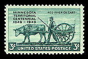
Red River ox cart
The Red River cart was a large two-wheeled cart made entirely of non-metallic materials. Often drawn by oxen, though also by horses or mules, these carts were used throughout most of the 19th century in the fur trade and in westward expansion in Canada and the United States, in the area of the Red...
routes connecting the Red River Colony
Red River Colony
The Red River Colony was a colonization project set up by Thomas Douglas, 5th Earl of Selkirk in 1811 on of land granted to him by the Hudson's Bay Company under what is referred to as the Selkirk Concession. The colony along the Red River of the North was never very successful...
(the "Selkirk Settlement") and Fort Garry
Fort Garry
Fort Garry, also known as Upper Fort Garry, was a Hudson's Bay Company trading post at the confluence of the Red and Assiniboine rivers in what is now downtown Winnipeg. It was established in 1822 on or near the site of the North West Company's Fort Gibraltar. Fort Garry was named after Nicholas...
in British North America
Canada under British Imperial Control (1764-1867)
Territories, colonies and provinces that would become part of modern Canada were under control of the English, and later British, Empire from the sixteenth century, when France also had claims in the area. However, the most populous areas of Canada in the St...
with the head of navigation on the Mississippi River
Mississippi River
The Mississippi River is the largest river system in North America. Flowing entirely in the United States, this river rises in western Minnesota and meanders slowly southwards for to the Mississippi River Delta at the Gulf of Mexico. With its many tributaries, the Mississippi's watershed drains...
in the United States. These trade routes ran from the location of present-day Winnipeg in the Canadian province of Manitoba
Manitoba
Manitoba is a Canadian prairie province with an area of . The province has over 110,000 lakes and has a largely continental climate because of its flat topography. Agriculture, mostly concentrated in the fertile southern and western parts of the province, is vital to the province's economy; other...
across the international border and by a variety of routes across what is now the eastern part of North Dakota
North Dakota
North Dakota is a state located in the Midwestern region of the United States of America, along the Canadian border. The state is bordered by Canada to the north, Minnesota to the east, South Dakota to the south and Montana to the west. North Dakota is the 19th-largest state by area in the U.S....
and western and central Minnesota
Minnesota
Minnesota is a U.S. state located in the Midwestern United States. The twelfth largest state of the U.S., it is the twenty-first most populous, with 5.3 million residents. Minnesota was carved out of the eastern half of the Minnesota Territory and admitted to the Union as the thirty-second state...
to Mendota
Mendota, Minnesota
Mendota is a city in Dakota County, Minnesota, United States. The name comes from the Dakota word for "where the waters meet." The population was 198 at the 2010 census.-History:...
and Saint Paul, Minnesota
Saint Paul, Minnesota
Saint Paul is the capital and second-most populous city of the U.S. state of Minnesota. The city lies mostly on the east bank of the Mississippi River in the area surrounding its point of confluence with the Minnesota River, and adjoins Minneapolis, the state's largest city...
on the Mississippi.
Travellers began to use the trails by the 1820s, with the heaviest use from the 1840s to the early 1870s, when they were superseded by railways. Until then, these cartways provided the most efficient means of transportation between the isolated Red River Colony and the outside world. They gave the Selkirk colonists and their neighbours, the people, an outlet for their furs
Fur trade
The fur trade is a worldwide industry dealing in the acquisition and sale of animal fur. Since the establishment of world market for in the early modern period furs of boreal, polar and cold temperate mammalian animals have been the most valued...
and a source of supplies other than the Hudson's Bay Company
Hudson's Bay Company
The Hudson's Bay Company , abbreviated HBC, or "The Bay" is the oldest commercial corporation in North America and one of the oldest in the world. A fur trading business for much of its existence, today Hudson's Bay Company owns and operates retail stores throughout Canada...
, which was unable to enforce its monopoly in the face of the competition that used the trails.
Free traders, independent of the Hudson's Bay Company and outside its jurisdiction, developed extensive commerce with the United States, making Saint Paul the principal entrepôt
Entrepôt
An entrepôt is a trading post where merchandise can be imported and exported without paying import duties, often at a profit. This profit is possible because of trade conditions, for example, the reluctance of ships to travel the entire length of a long trading route, and selling to the entrepôt...
and link to the outside world for the Selkirk Settlement. The trade developed by and along the trails connecting Fort Garry with Saint Paul stimulated commerce, contributed to the settlement of Minnesota and North Dakota in the United States, and accelerated the settlement of Canada to the west of the rugged barrier known as the Canadian Shield
Canadian Shield
The Canadian Shield, also called the Laurentian Plateau, or Bouclier Canadien , is a vast geological shield covered by a thin layer of soil that forms the nucleus of the North American or Laurentia craton. It is an area mostly composed of igneous rock which relates to its long volcanic history...
. For a time, this cross-border trade even threatened Canada's control of its western territories. The threat diminished after completion of transcontinental trade route
Trade route
A trade route is a logistical network identified as a series of pathways and stoppages used for the commercial transport of cargo. Allowing goods to reach distant markets, a single trade route contains long distance arteries which may further be connected to several smaller networks of commercial...
s both north and south of the border, and the transportation corridor through which the trails once ran declined in importance. That corridor has now seen a resurgence of traffic, carried by more modern means of transport than the crude ox carts that once travelled the Red River Trails.
Origins
In 1812, Thomas Douglas, 5th Earl of SelkirkThomas Douglas, 5th Earl of Selkirk
Thomas Douglas, 5th Earl of Selkirk was a Scottish peer. He was born at Saint Mary's Isle, Kirkcudbrightshire, Scotland. He was noteworthy as a Scottish philanthropist who sponsored immigrant settlements in Canada at the Red River Colony.- Early background :Douglas was the seventh son of Dunbar...
, started a colony of settlers in British North America
British North America
British North America is a historical term. It consisted of the colonies and territories of the British Empire in continental North America after the end of the American Revolutionary War and the recognition of American independence in 1783.At the start of the Revolutionary War in 1775 the British...
where the Assiniboine River
Assiniboine River
The Assiniboine River is a river that runs through the prairies of Western Canada in Saskatchewan and Manitoba. It is a tributary of the Red River. The Assiniboine is a typical meandering river with a single main channel embanked within a flat, shallow valley in some places and a steep valley in...
joins the Red River
Red River of the North
The Red River is a North American river. Originating at the confluence of the Bois de Sioux and Otter Tail rivers in the United States, it flows northward through the Red River Valley and forms the border between the U.S. states of Minnesota and North Dakota before continuing into Manitoba, Canada...
at the site of modern Winnipeg. Although fur posts were scattered throughout the Canadian northwest, and settlements of fur trade
Fur trade
The fur trade is a worldwide industry dealing in the acquisition and sale of animal fur. Since the establishment of world market for in the early modern period furs of boreal, polar and cold temperate mammalian animals have been the most valued...
rs and bison
Bison
Members of the genus Bison are large, even-toed ungulates within the subfamily Bovinae. Two extant and four extinct species are recognized...
hunters were located in the vicinity of Selkirk’s establishment, this colony was the only agricultural settlement between Upper Canada
Upper Canada
The Province of Upper Canada was a political division in British Canada established in 1791 by the British Empire to govern the central third of the lands in British North America and to accommodate Loyalist refugees from the United States of America after the American Revolution...
and the Pacific Ocean. Isolated by geology behind the rugged Canadian Shield
Canadian Shield
The Canadian Shield, also called the Laurentian Plateau, or Bouclier Canadien , is a vast geological shield covered by a thin layer of soil that forms the nucleus of the North American or Laurentia craton. It is an area mostly composed of igneous rock which relates to its long volcanic history...
and many hundreds of miles of wilderness, settlers and their neighbours had access to outside markets and sources of supply only by two laborious water routes.
The first, maintained by the Hudson's Bay Company
Hudson's Bay Company
The Hudson's Bay Company , abbreviated HBC, or "The Bay" is the oldest commercial corporation in North America and one of the oldest in the world. A fur trading business for much of its existence, today Hudson's Bay Company owns and operates retail stores throughout Canada...
(in which Lord Selkirk was a principal investor), was a sea route from Great Britain to York Factory on Hudson Bay
Hudson Bay
Hudson Bay , sometimes called Hudson's Bay, is a large body of saltwater in northeastern Canada. It drains a very large area, about , that includes parts of Ontario, Quebec, Saskatchewan, Alberta, most of Manitoba, southeastern Nunavut, as well as parts of North Dakota, South Dakota, Minnesota,...
, then up a chain of rivers and lakes to the colony, 780 miles (1250 km) from salt water to the Assiniboine. The alternative was the historic route of the rival North West Company
North West Company
The North West Company was a fur trading business headquartered in Montreal from 1779 to 1821. It competed with increasing success against the Hudson's Bay Company in what was to become Western Canada...
's voyageurs from Montreal
Montreal
Montreal is a city in Canada. It is the largest city in the province of Quebec, the second-largest city in Canada and the seventh largest in North America...
through Lake Huron
Lake Huron
Lake Huron is one of the five Great Lakes of North America. Hydrologically, it comprises the larger portion of Lake Michigan-Huron. It is bounded on the east by the Canadian province of Ontario and on the west by the state of Michigan in the United States...
to Fort William
Fort William, Ontario
Fort William was a city in Northern Ontario, located on the Kaministiquia River, at its entrance to Lake Superior. It amalgamated with Port Arthur and the townships of Neebing and McIntyre to form the city of Thunder Bay in January 1970. Ever since then it has been the largest city in Northwestern...
on Lake Superior
Lake Superior
Lake Superior is the largest of the five traditionally-demarcated Great Lakes of North America. It is bounded to the north by the Canadian province of Ontario and the U.S. state of Minnesota, and to the south by the U.S. states of Wisconsin and Michigan. It is the largest freshwater lake in the...
. Above Superior, this route followed rivers and lakes to Lac la Croix
Lac La Croix First Nation
Lac La Croix First Nation is a Saulteaux First Nation located in Rainy River District in northwestern Ontario, Canada, along the Ontario-Minnesota border. It is approximately 200 km northwest of Thunder Bay, Ontario...
and west along the international border through Lake of the Woods
Lake of the Woods
Lake of the Woods is a lake occupying parts of the Canadian provinces of Ontario and Manitoba and the U.S. state of Minnesota. It separates a small land area of Minnesota from the rest of the United States. The Northwest Angle and the town of Angle Township can only be reached from the rest of...
to Rat Portage, and then down the Winnipeg River
Winnipeg River
The Winnipeg River is a Canadian river which flows from Lake of the Woods in the province of Ontario to Lake Winnipeg in Manitoba. This river is long from the Norman Dam in Kenora to its mouth at Lake Winnipeg. Its watershed is in area, mainly in Canada. About of this area is in northern...
to the Red. The distance from the Selkirk settlement to Lake Superior at Fort William was about 500 miles (800 km), but Lake Superior was only the start of a lengthy journey to Montreal where furs and supplies would be transshipped to and from Europe.
Neither of these routes was suitable for heavy freight. Lighter cargoes were carried in York boat
York boat
The York boat was an inland boat used by the Hudson's Bay Company to carry furs and trade goods along inland waterways in Rupert's Land and the Columbia District. It was named after York Factory, the headquarters of the HBC, and modeled after Orkney Islands fishing boats...
s to Hudson Bay or in canoes on the border route. Both routes required navigation of large and hazardous lakes, shallow and rapid-strewn rivers, and swampy creeks and bogs, connected by numerous portages where both cargo and watercraft had to be carried on men's backs.
But geology also provided an alternate route, albeit across foreign territory. The valleys of the Red and Minnesota River
Minnesota River
The Minnesota River is a tributary of the Mississippi River, approximately 332 miles long, in the U.S. state of Minnesota. It drains a watershed of nearly , in Minnesota and about in South Dakota and Iowa....
s lay in the beds of Glacial Lake Agassiz and its prehistoric outlet Glacial River Warren
Glacial River Warren
right|thumb|210px|The course of the Minnesota River follows the valley carved by Glacial River WarrenGlacial River Warren or River Warren was a prehistoric river that drained Lake Agassiz in central North America between 11,700 and 9,400 years ago...
; the lands exposed when these bodies of water receded were flat plains between low uplands covered by prairie grasslands. At the Traverse Gap
Traverse Gap
The Traverse Gap is an ancient river channel occupied by Lake Traverse and Big Stone Lake and the valley connecting them at Browns Valley, Minnesota. It is located on the border of the U.S. states of Minnesota and South Dakota...
, only a mile (1.6 km) of land separated the Bois des Sioux River, a source stream of the Red (which flowed north to Hudson Bay) and the Little Minnesota River
Little Minnesota River
The Little Minnesota River is a headwaters tributary of the Minnesota River in northeastern South Dakota and west-central Minnesota in the United States...
, a source stream of the Minnesota River (tributary to the Mississippi, which flowed south to the Gulf of Mexico
Gulf of Mexico
The Gulf of Mexico is a partially landlocked ocean basin largely surrounded by the North American continent and the island of Cuba. It is bounded on the northeast, north and northwest by the Gulf Coast of the United States, on the southwest and south by Mexico, and on the southeast by Cuba. In...
). The valley floors and uplands of the watercourses along this gently graded route provided a natural thoroughfare to the south. The eyes of the colonists therefore turned to the new United States, both as a source of supplies and an (illegal) outlet for their furs.
Development of the routes
The rich fur areas along the upper Mississippi, Minnesota, Des MoinesDes Moines River
The Des Moines River is a tributary river of the Mississippi River, approximately long to its farther headwaters, in the upper Midwestern United States...
, and Missouri River
Missouri River
The Missouri River flows through the central United States, and is a tributary of the Mississippi River. It is the longest river in North America and drains the third largest area, though only the thirteenth largest by discharge. The Missouri's watershed encompasses most of the American Great...
s, otherwise occupied only by peoples of the First Nations
First Nations
First Nations is a term that collectively refers to various Aboriginal peoples in Canada who are neither Inuit nor Métis. There are currently over 630 recognised First Nations governments or bands spread across Canada, roughly half of which are in the provinces of Ontario and British Columbia. The...
, were exploited by independent fur traders operating from Prairie du Chien, Wisconsin
Prairie du Chien, Wisconsin
Prairie du Chien is a city in and the county seat of Crawford County, Wisconsin, United States. The population was 5,911 at the 2010 census. Its Zip Code is 53821....
in the late eighteenth century. At the beginning of the nineteenth century, these traders established fur posts in the Minnesota River valley at Lake Traverse
Lake Traverse
Lake Traverse is the southernmost body of water in the Hudson Bay watershed of North America. It lies along the border between the U.S. states of Minnesota and South Dakota...
, Big Stone Lake
Big Stone Lake
Big Stone Lake is a long, narrow freshwater lake and reservoir forming the border between western Minnesota and northeastern South Dakota in the USA. The lake covers 12,610 acres of surface area, stretching 26 miles from end to end and averaging around 1 mile wide, and at an elevation of 965...
, Lac qui Parle
Lac qui Parle
Lac qui Parle is a reservoir located in western Minnesota, United States, which was formed by the damming of the Minnesota River. The dam was built by the Works Progress Administration . Lac qui Parle is a French translation of the native Dakota name, meaning "lake which speaks".The northernmost...
, and Traverse des Sioux
Traverse des Sioux
Traverse des Sioux is a historic site in the U.S. state of Minnesota. Once part of a preindustrial trade route, it commemorates that route, a busy river crossing on it, a nineteenth century settlement, trading post, and mission at that crossing place, a transshipment point for pelts in fur trading...
. The large fur companies also built posts, including the North West Company's stations at Pembina
Pembina, North Dakota
Pembina is a city in Pembina County, North Dakota in the United States. The population was 592 at the 2010 census.The area of Pembina was long inhabited by various indigenous peoples...
and St. Joseph
Walhalla, North Dakota
As of the census of 2000, there were 1,057 people, 452 households, and 271 families residing in the city. The population density was 1,004.4 people per square mile . There were 556 housing units at an average density of 528.3 per square mile . The racial makeup of the city was 89.78% White, 5.96%...
in the valley of the Red River. The paths between these posts became parts of the first of the Red River Trails.
In 1815, 1822, and 1823, cattle were herded to the Red River colony from Missouri by a route up the Des Moines River Valley to the Minnesota River then down the Red River to the Selkirk settlement. In 1819, following a devastating plague of locusts which left the colonists with insufficient seed even to plant a crop, an expedition was sent by snowshoe to purchase seed at Prairie du Chien. It returned by flatboat
Flatboat
Fil1800flatboat.jpgA flatboat is a rectangular flat-bottomed boat with Fil1800flatboat.jpgA flatboat is a rectangular flat-bottomed boat with Fil1800flatboat.jpgA flatboat is a rectangular flat-bottomed boat with (mostlyNOTE: "(parenthesized)" wordings in the quote below are notes added to...
up the Mississippi and Minnesota Rivers and down the Red River, arriving back at the settlement in the summer of 1820. In 1821, five dissatisfied settler families left the colony for Fort Snelling, the forerunners of later tides of migration up and down the valley between the two nations. Two years later in 1823, Major Stephen Harriman Long
Stephen Harriman Long
Stephen Harriman Long was a U.S. army explorer, topographical engineer, and railway engineer. As an inventor, he is noted for his developments in the design of steam locomotives. He was also one of the most prolific explorers of the early 1800s, although his career as an explorer was relatively...
was the first official U.S. representative to reach Pembina; his expedition came by way of the Minnesota and Red Rivers. These early expeditions on the watersheds of these two streams were among the earliest known through trips on the route of the first Red River Trail.
West Plains Trail
The West Plains Trail had originated with Native Americans, and before the ox cart traffic it connected the fur-trading postTrading post
A trading post was a place or establishment in historic Northern America where the trading of goods took place. The preferred travel route to a trading post or between trading posts, was known as a trade route....
s of the Columbia Fur Company. In fact, that company introduced the Red River ox cart
Red River ox cart
The Red River cart was a large two-wheeled cart made entirely of non-metallic materials. Often drawn by oxen, though also by horses or mules, these carts were used throughout most of the 19th century in the fur trade and in westward expansion in Canada and the United States, in the area of the Red...
to haul its furs and goods. It also developed the trails, and by the early 1830s, an expedition from the Selkirk settlement driving a flock of sheep from Kentucky to the Assiniboine found the trail to be well-marked.
From the Red River Settlement, the trail went south upstream along the Red River's west bank to Pembina, just across the international border. Pembina had been a fur-trading post since the last decade of the eighteenth century. From there, some traffic continued south along the river, but most cart trains went west along the Pembina River
Pembina River (North Dakota)
The Pembina River is a tributary of the Red River of the North, approximately long, in southern Manitoba in Canada and northeastern North Dakota in the United States. It drains an area of the prairie country along the U.S.-Canada border, threading the Manitoba-North Dakota border eastward to the...
to St. Joseph
Walhalla, North Dakota
As of the census of 2000, there were 1,057 people, 452 households, and 271 families residing in the city. The population density was 1,004.4 people per square mile . There were 556 housing units at an average density of 528.3 per square mile . The racial makeup of the city was 89.78% White, 5.96%...
near the border and then south, or else cut the corner to the southwest in order to intercept the southbound trail from St. Joseph. This north-south trail paralleled the Red River about thirty miles (50 km) to the west. By staying on the uplands west of the Red River, this route avoided crossing the tributaries of that river near their confluences with the Red, and also kept out of the swampy, flood-prone, and mosquito-ridden bottomlands in the lakebed of Glacial Lake Agassiz which the river drained.
North Dakota
North Dakota is a state located in the Midwestern region of the United States of America, along the Canadian border. The state is bordered by Canada to the north, Minnesota to the east, South Dakota to the south and Montana to the west. North Dakota is the 19th-largest state by area in the U.S....
, the trail veered to the south-southeast to close with the Red River at Georgetown
Georgetown, Minnesota
Georgetown is a city in Clay County, Minnesota, United States, along the Buffalo River near its confluence with the Red River of the North. The population was 129 at the 2010 census.-Geography:...
, Fort Abercrombie
Fort Abercrombie
Fort Abercrombie, in North Dakota, was an American fort established by authority of an act of Congress, March 3, 1857. The act allocated twenty-five square miles of land on the Red River in Dakota Territory to be used for a military outpost, but the exact location was left to the discretion of...
, and Breckenridge, Minnesota
Breckenridge, Minnesota
As of the census of 2000, there were 3,559 people, 1,438 households, and 911 families residing in the city. The population density was 1,516.4 people per square mile . There were 1,582 housing units at an average density of 674.0 per square mile...
, all of which came into existence in consequence of the passing cart traffic. From Breckenridge, the trail continued upstream along the east bank of the Red and Bois des Sioux Rivers to the continental divide at Lake Traverse. Some traffic went along the lakeshore through the Traverse Gap
Traverse Gap
The Traverse Gap is an ancient river channel occupied by Lake Traverse and Big Stone Lake and the valley connecting them at Browns Valley, Minnesota. It is located on the border of the U.S. states of Minnesota and South Dakota...
on the continental divide, then down either side of Big Stone Lake, source of the Minnesota River, while other carters took a short cut directly south from the Bois des Sioux across the open prairie through modern Graceville, Minnesota
Graceville, Minnesota
At the 2000 census, there were 605 people, 257 households and 149 families residing in the city. The population density was 1,007.7 per square mile . There were 283 housing units at an average density of 471.4 per square mile . The racial makeup of the city was 99.50% White, 0.17% Native...
thereby avoiding the wet country in the Traverse Gap.
The trail continued on intertwined routes down both sides of the valley of the Minnesota River past fur posts at Lac qui Parle
Lac Qui Parle State Park
Lac qui Parle State Park is a Minnesota state park near Watson. Lac qui Parle is a French translation of the native Dakota name, meaning "lake which speaks"...
and downstream locations, and the Upper Sioux
Upper Sioux Agency State Park
Upper Sioux Agency State Park is a Minnesota state park on the Minnesota River, south of Granite Falls. It preserves the site of the historic Yellow Medicine Agency which was destroyed in the Dakota War of 1862.-External links:*...
and Lower Sioux Indian Agencies and Fort Ridgely
Fort Ridgely
Fort Ridgely was a United States Army outpost near the Dakota reservation in southwestern Minnesota . Built between 1853–1855, it played an important role in the Dakota War of 1862...
, all established in the 1850s. From Fort Ridgely, the trail struck across the open prairie to the Minnesota River at Traverse des Sioux
Traverse des Sioux
Traverse des Sioux is a historic site in the U.S. state of Minnesota. Once part of a preindustrial trade route, it commemorates that route, a busy river crossing on it, a nineteenth century settlement, trading post, and mission at that crossing place, a transshipment point for pelts in fur trading...
near modern-day St. Peter, Minnesota
St. Peter, Minnesota
St. Peter is a city in Nicollet County, Minnesota, United States. The population was 11,196 at the 2010 census. It is the county seat of Nicollet County.St...
, where the furs and goods were, at first, usually transshipped to flatboats. In later years, most cart trains crossed to the east bank and proceeded northeast along the wooded river bottoms and uplands to Fort Snelling or Mendota, where the Minnesota River joined the Mississippi. From there furs were shipped down the Mississippi River to Saint Louis and other markets.
Sporadic at first, trade between Fort Garry and the Mississippi became more regular in 1835, when a caravan of traders from the Red River came to Mendota. The efforts of the Hudson’s Bay Company to enforce its monopoly only induced the fur traders to avoid the company's jurisdiction by moving across the border to the United States. These included Norman Kittson
Norman Kittson
Norman Wolfred Kittson was variously a fur trader, steamboat-line operator, and railway entrepreneur.-Fur trader:...
whose enormous fur-trading and shipping enterprise along the West Plains Trail started with one six-cart train in 1844. In later years, trains consisting of hundreds of ox carts were sent from Kittson’s post at Pembina, just inside U.S. territory and safely outside the reach of the Hudson’s Bay Company. While some of this fur traffic was shifted to other routes in 1854, the forts, missions, Indian agencies, and remaining through traffic to Fort Garry kept the trails busy, and they were improved in the 1850s and supplemented by military roads.
Woods Trail
The West Plains Trail, although relatively level, went by a lengthy route through the lands of the DakotaSioux
The Sioux are Native American and First Nations people in North America. The term can refer to any ethnic group within the Great Sioux Nation or any of the nation's many language dialects...
people, and the shorter East Plains Trail also skirted Dakota land. The Dakota were the enemy of the Ojibwa
Ojibwa
The Ojibwe or Chippewa are among the largest groups of Native Americans–First Nations north of Mexico. They are divided between Canada and the United States. In Canada, they are the third-largest population among First Nations, surpassed only by Cree and Inuit...
, to whom the carters were related by blood and marriage. These tensions led to conflicts. One such bloody confrontation in the summer of 1844 (caused by an attack by carters on Dakota hunters) occurred when that year's expedition of free traders were in Saint Paul
Saint Paul, Minnesota
Saint Paul is the capital and second-most populous city of the U.S. state of Minnesota. The city lies mostly on the east bank of the Mississippi River in the area surrounding its point of confluence with the Minnesota River, and adjoins Minneapolis, the state's largest city...
. This meant that they could not safely return by the normal route. The traders therefore struck northwest up the Mississippi to Crow Wing
Old Crow Wing, Minnesota
Old Crow Wing is a ghost town in Fort Ripley Township, Crow Wing County, Minnesota, United States, at the confluence of the Mississippi and Crow Wing rivers. For over a century, it was the northernmost European-American settlement on the Mississippi. In the 1850s and 1860s, it was the county seat...
at the mouth of the Crow Wing River
Crow Wing River
The Crow Wing River is a tributary of the Mississippi River approximately in length. The river arises in a chain of 11 lakes in southern Hubbard County, Minnesota and flows generally southeast, entering the Mississippi at Crow Wing State Park, northwest of Little Falls, Minnesota. Its name is a...
, west up that river and across the height of land to the fur post at Otter Tail Lake
Otter Tail Lake
Otter Tail Lake is a lake in the west-central part of the U.S. state of Minnesota and is the largest lake in Otter Tail County.- Geography :Adjoining the city of Ottertail, it is a part of the Otter Tail River chain of lakes. Upstream from the lake are Big Pine, Little Pine and Rush lakes, while...
, then northwest across the prairie to a crossing of the Red River near its confluence with the Forest River
Forest River (North Dakota)
The Forest River is an tributary of the Red River of the North in eastern North Dakota in the United States. It rises in Walsh County and flows southeast and east, past the towns of Fordville and Minto, and forms a confluence with the Red approximately north of Grand Forks....
. The next year, a southbound party followed its tracks, and by the year after (1846), the final route had been well-established inland from the Red River bottomlands. This trail was known as the Woods or Crow Wing Trail; it was also known locally as the Saint Paul Trail and Pembina Trail.
Roseau River (Manitoba)
The Roseau River is a tributary of the Red River of the North, in southern Manitoba in Canada and northwestern Minnesota in the United States. Via the Red River, Lake Winnipeg and the Nelson River, it is part of the watershed of Hudson Bay....
and the international border. In Minnesota, the trail was joined by a route coming from Pembina to the northwest, and continued south on a level prairie in the former lakebed of prehistoric Lake Agassiz. It ascended to and followed a firm gravelly ridge which was once among the higher beaches or strandlines of that ancient lake, forded the Red Lake River
Red Lake River
The Red Lake River is a river located in northwestern Minnesota. The river begins on the western side of the Lower Red Lake and flows westward. After passing through Thief River Falls, Red Lake Falls, and Crookston, the river merges with the Red River of the North in East Grand Forks. The total...
at the Old Crossing near modern Huot
Huot, Minnesota
Huot is an unincorporated community in Louisville Township, Red Lake County, Minnesota, United States. The name of the village evokes the French-Canadian and Métis history of the Red River Trails and the Pembina settlements of Assiniboia.-History:...
, and angled south by southeast to the fur post at White Earth
White Earth, Minnesota
White Earth is a census-designated place in Becker County, Minnesota, United States. The population was 424 at the 2000 census.-Geography:...
. At Otter Tail Lake, the route left the plains and turned east into a forest in the Leaf Mountains on the continental divide. Taking a difficult but scenic path east through the woods, the trail crossed the Mississippi River at Old Crow Wing. It then went south down the east bank of that river on a smooth and open glacial outwash sandplain to Sauk Rapids
Sauk Rapids, Minnesota
As of the census of 2000, there were 10,213 people, 3,921 households, and 2,599 families residing in the city. The population density was 2,234.1 people per square mile . There were 4,017 housing units at an average density of 878.7 per square mile...
and East Saint Cloud
St. Cloud, Minnesota
St. Cloud is a city in the U.S. state of Minnesota and the largest population center in the state's central region. The population was 65,842 at the 2010 census. It is the county seat of Stearns County...
.
The final lap of the trail to Saint Paul, which had replaced Mendota as the principal entrepôt
Entrepôt
An entrepôt is a trading post where merchandise can be imported and exported without paying import duties, often at a profit. This profit is possible because of trade conditions, for example, the reluctance of ships to travel the entire length of a long trading route, and selling to the entrepôt...
for the cart trade, continued along the sandplain on the east bank of the Mississippi. This route ran within a few miles of the river to Saint Anthony Falls
Saint Anthony Falls
Saint Anthony Falls, or the Falls of Saint Anthony, located northeast of downtown Minneapolis, Minnesota, was the only natural major waterfall on the Upper Mississippi River. The natural falls was replaced by a concrete overflow spillway after it partially collapsed in 1869...
and the community of that name which was growing on the east bank of the Mississippi. The trail then left the river and crossed open country to Saint Paul. The carters camped on the uplands west of the steamboat landing during the interval between their arrival with the furs and their return to the north with supplies and trade goods.
Inferior in terrain to other routes, the Woods Trail was superior in safety, as it was well within the lands of the Ojibwa. It was less well used during times of relative calm. In the late 1850s, its utility was increased by improvements made by the U.S. Army, which straightened and improved the winding ox path through the woods along the Leaf and Crow Wing Rivers, and also replaced the old trail along the Mississippi River between Fort Ripley (near Crow Wing) and Sauk Rapids with a military road.
East Plains Trail
Henry Hastings Sibley
Henry Hastings Sibley was the first Governor of the U.S. state of Minnesota.-Early life and education:...
retired from the fur trade in 1854. His successor and former partner Norman Kittson moved their company's cart trains from the West Plains Trail in the Minnesota River valley to the East Plains route.
The East Plains Trail followed the older routes of the West Plains Trail from Pembina to Breckenridge, Minnesota, then struck east by a variety of routes out of the Red River Valley across the upper valleys of the Pomme de Terre
Pomme de Terre River (Minnesota)
The Pomme de Terre River is a tributary of the Minnesota River, 106 miles long, in western Minnesota in the United States. Via the Minnesota River, it is part of the watershed of the Mississippi River, draining an area of 875 square miles in an agricultural region...
and Chippewa Rivers
Chippewa River (Minnesota)
The Chippewa River is a tributary of the Minnesota River, about 120 mi long, in western and southwestern Minnesota in the United States...
(tributaries of the Minnesota River), to Saint Cloud
St. Cloud, Minnesota
St. Cloud is a city in the U.S. state of Minnesota and the largest population center in the state's central region. The population was 65,842 at the 2010 census. It is the county seat of Stearns County...
and Sauk Rapids
Sauk Rapids, Minnesota
As of the census of 2000, there were 10,213 people, 3,921 households, and 2,599 families residing in the city. The population density was 2,234.1 people per square mile . There were 4,017 housing units at an average density of 878.7 per square mile...
on the Upper Mississippi. Soon however, a branch was added to connect the East Plains Trail with the Woods Trail. This link skirted the west slope of the Leaf Mountains and joined the East Plains routes at Elbow Lake
Elbow Lake, Grant County, Minnesota
Elbow Lake is a city in, and the county seat of, Grant County, Minnesota, United States. The population was 1,176 at the 2010 census.-Geography:...
or near the Otter Tail River
Otter Tail River
The Otter Tail River is a river in the west-central portion of the U.S. state of Minnesota. It begins in Clearwater County, southwest of Bemidji...
. At times, this eastern connection may have been the better-travelled of the two variants.
At Saint Cloud, the furs of some of the cart brigades were transshipped to river craft on the Mississippi, which operated to Saint Anthony Falls at Minneapolis
Minneapolis, Minnesota
Minneapolis , nicknamed "City of Lakes" and the "Mill City," is the county seat of Hennepin County, the largest city in the U.S. state of Minnesota, and the 48th largest in the United States...
. Other cart trains crossed the Mississippi and travelled on to Saint Paul on a route shared with the Woods Trail.
Over most of its route, the East Plains Trail went through a post-glacial landscape of lakes, moraines, and drumlins, with beautiful scenery and difficult swamps. As the area became settled during Minnesota’s territorial and early statehood days, the routes were improved, stagecoach
Stagecoach
A stagecoach is a type of covered wagon for passengers and goods, strongly sprung and drawn by four horses, usually four-in-hand. Widely used before the introduction of railway transport, it made regular trips between stages or stations, which were places of rest provided for stagecoach travelers...
service was instituted, towns were established, and permanent settlement began.
Commerce
The trails were first used to obtain seed and supplies for the Selkirk colony. They soon became trade routeTrade route
A trade route is a logistical network identified as a series of pathways and stoppages used for the commercial transport of cargo. Allowing goods to reach distant markets, a single trade route contains long distance arteries which may further be connected to several smaller networks of commercial...
s for local fur traders, and in the 1830s began to be heavily used by American fur traders operating just south of the international border. The Americans acquired furs from fur traders in British North America who were evading the Hudson's Bay Company monopoly on trade within its chartered domain.
The settlement at Fort Garry was isolated and at the end of a seven-hundred mile (1100 km) water and land route from York Factory, which was served by only one or two ships each year. Orders from Britain had to be placed a year in advance. But from Saint Paul, the settlers could obtain staples and other goods in the span of a single summer. In the face of these relative inconveniences and the economy of shipping over the trails, the Hudson’s Bay Company was unable to compel all trade to go by way of York Factory on Hudson Bay, and by 1850 the company’s monopoly was broken. In fact, the company itself all but abandoned the York Factory route for heavy trade in 1857, and instead shipped its own traffic in bond through the United States and over the Red River Trails.
The principal export from the Red River settlements was fur, but as the colony passed from a subsistence economy to one producing more than could be consumed locally the agricultural surplus was also sent south by ox cart. The imports were more varied; originally they were seed, spices, and other staples, liquor, tools, implements, and hardware. In midcentury the buffalo
American Bison
The American bison , also commonly known as the American buffalo, is a North American species of bison that once roamed the grasslands of North America in massive herds...
herds declined, and traffic in furs began to be replaced by the produce and needs of settlers. As settlement developed the trails became a "common carrier" for all manner of goods that could be carried by ox cart, including lamps and coal oil to burn in them, fine cloth, books, general merchandise, champagne, sheet-metal stoves, disassembled farm machinery and at least one piano, and a printing press and other accoutrements for the first newspaper in the Fort Garry region.
Life on the trail
Mortise and tenon
The mortise and tenon joint has been used for thousands of years by woodworkers around the world to join pieces of wood, mainly when the adjoining pieces connect at an angle of 90°. In its basic form it is both simple and strong. Although there are many joint variations, the basic mortise and tenon...
. The axle was also made of seasoned oak. It was lashed to the cart by strips of wet bison
American Bison
The American bison , also commonly known as the American buffalo, is a North American species of bison that once roamed the grasslands of North America in massive herds...
hide known by its Cree
Cree
The Cree are one of the largest groups of First Nations / Native Americans in North America, with 200,000 members living in Canada. In Canada, the major proportion of Cree live north and west of Lake Superior, in Ontario, Manitoba, Saskatchewan, Alberta and the Northwest Territories, although...
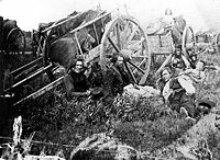
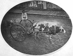
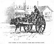
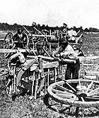
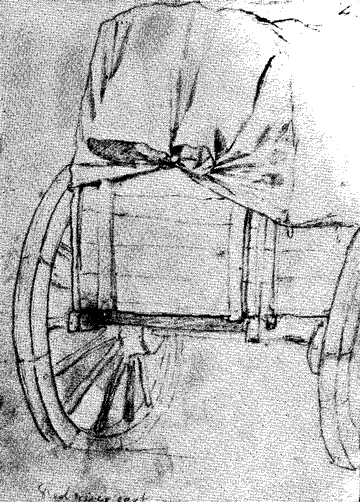
name of shaganappi, which shrank and tightened as they dried. The axles connected two spoked wheels, five or six feet in diameter, which were "dished" or in the form of a shallow cone, the apex of which was at the hubs, which were inboard of the rims. The carts were originally drawn by small horses obtained from the First Nations. After cattle were brought to the colony in the 1820s, oxen were used to haul the carts. They were preferred because of their strength, endurance, and cloven hooves which spread their weight in swampy areas.
The cart, constructed of native materials, could easily be repaired. A supply of shaganappi and wood was carried as a cart could break a half-dozen axles in a one-way trip. The axles were unlubricated, as grease would capture dust which would act as sandpaper and immobilize the cart. The resultant squeal sounded like an untuned violin, giving it the sobriquet of "the North West fiddle". One visitor wrote that "a den of wild beasts cannot be compared with its hideousness". The noise was audible for miles. The carts were completely unsprung, and only their flexible construction cushioned the shocks transmitted from the humps and hollows of the trail.
Southbound, the carts were loaded with fur, packed into the 90-pound (40 kg) bundles known in the fur trade as . A cart could handle up to 800–1,000 pounds (360–450 kg). On their return the traders carried staples, trade goods, and manufactured goods unavailable at Fort Garry. In both directions, the cargo was covered with hide or canvas. The carts were lashed together in brigades of ten carts, with three drivers and an overseer. These brigades could join in trains up to two miles (three km) in length. Carts numbering in the low hundreds annually used the trails in the 1840s, many hundreds in the 1850s, and thousands in the late 1860s. These cart trains travelled about two miles (three km) an hour, and about twenty miles (thirty km) in a day.
Streamside camps offered wood, water, and some protection from the hazards of open land. The prairie could be dangerous in time of native unrest, and trade ceased entirely for a time during the Dakota War of 1862
Dakota War of 1862
The Dakota War of 1862, also known as the Sioux Uprising, was an armed conflict between the United States and several bands of the eastern Sioux. It began on August 17, 1862, along the Minnesota River in southwest Minnesota...
. Prairie fires, driven by winds, were a risk in dry spells. Wet weather turned rivers into torrents, approaches to streams into bogs, and worn paths into morasses. Blizzards could strand traders and threaten them with starvation. Insects harassed both the traders and their draft animals, depriving them of sleep and weakening them.
There were compensations. Game was plentiful and the traders rarely lacked fresh meat. Some saw in the seemingly boundless prairies a colourful ocean of grass, and summer storms could be awe-inspiring, although dangerous. While the prairie had its own grandeur, after weeks of travel over treeless steppe
Steppe
In physical geography, steppe is an ecoregion, in the montane grasslands and shrublands and temperate grasslands, savannas, and shrublands biomes, characterized by grassland plains without trees apart from those near rivers and lakes...
the rivers, lakes, and woods of central Minnesota were a welcome relief.
After six or so weeks on the trail, the brigades reached Saint Paul. There the carters camped on the bluff above the town growing on the riverfront. Not all was harmonious. To the locals, the swarthy-complected carters up on the hill had a "devil-may-care" aspect, with their "curious commingling of civilized garments and barbaric adornments". One trader from the north called his host city "a wretched little village" where "drinking whisky seems to occupy at least half the time of the worth[y] citizens", while the rest were "employed in cheating each other or imposing upon strangers." The economic benefits of trade, and the separation of the carters' camp from the village below, may have helped keep relations civil. After about three weeks of trading, the "wild" carters from the north, now laden with goods, took their leave of the "den of blackguards" that was Saint Paul, returning to what they felt was a more civilized world. Their erstwhile hosts, on the other hand, thought their visitors were returning to an uncivilized and frozen wilderness.
End of the trails
.jpg)
Flatboat
Fil1800flatboat.jpgA flatboat is a rectangular flat-bottomed boat with Fil1800flatboat.jpgA flatboat is a rectangular flat-bottomed boat with Fil1800flatboat.jpgA flatboat is a rectangular flat-bottomed boat with (mostlyNOTE: "(parenthesized)" wordings in the quote below are notes added to...
s and then shallow-draft steamboats ascended the Minnesota River to Traverse des Sioux and upstream points, where they were met by cart brigades travelling the West Plains Trail. In 1851, weekly steamboat service on the Mississippi began between Saint Anthony Falls and Sauk Rapids on the Middle and Woods trails. In 1859, steamboat machinery was carried overland to the Red River where a boat was built, but service was intermittent. The Dakota War of 1862 and the American Civil War
American Civil War
The American Civil War was a civil war fought in the United States of America. In response to the election of Abraham Lincoln as President of the United States, 11 southern slave states declared their secession from the United States and formed the Confederate States of America ; the other 25...
delayed further improvements.
After the Civil War, the age of steam came to the region. After Ojibwe title to the Red River Valley had been extinguished on the United States side of the Canadian border by the Treaty of Old Crossing
Treaty of Old Crossing
By the Treaty of Old Crossing and the Treaty of Old Crossing , the Pembina and Red Lake bands of the Ojibwe, then known as Chippewa Indians, purportedly ceded to the United States all of their rights to the Red River Valley...
in 1863, steamboat service was revived on the Red River, and railways were built west from Saint Paul and Duluth, Minnesota
Duluth, Minnesota
Duluth is a port city in the U.S. state of Minnesota and is the county seat of Saint Louis County. The fourth largest city in Minnesota, Duluth had a total population of 86,265 in the 2010 census. Duluth is also the second largest city that is located on Lake Superior after Thunder Bay, Ontario,...
on Lake Superior. A branch of the St. Paul and Pacific Railroad reached St. Cloud in 1866. Its mainline reached Willmar in 1869 and Benson, Minnesota
Benson, Minnesota
As of the census of 2000, there were 3,376 people, 1,451 households, and 880 families residing in the city. The population density was 1,360.5 people per square mile . There were 1,566 housing units at an average density of 631.1 per square mile...
the following year. Each end-of-track town in its turn became the terminus for many of the cart trains. In 1871, the railway reached the Red River at Breckenridge, where revived steamboat service carried the traffic the rest of way to Fort Garry. The long trains of carts drawn by oxen were replaced by railway trains powered by steam, and the trails reverted to nature.
A few traces of the vanished trails still exist. Some local roads follow their routes; depressions in the landscape show where thousands of carts once passed, and even after more than a century of winters and springs, freezing and thawing the land, there are still places where soils remain compacted and resistant to the plow. Some of these subtle artifacts are marked or are visible to one with a discerning eye, but in most places the trails have been obliterated. Their locations are noted at parks and wayside signs, and trail locations near Baxter
Baxter, Minnesota
As of the census of 2000, there were 5,555 people, 1,921 households, and 1,586 families residing in the city. The population density was 320.7 people per square mile . There were 1,979 housing units at an average density of 114.3 per square mile...
, St. Hilaire
St. Hilaire, Minnesota
St. Hilaire is a city in section 6 of River Falls Township in Pennington County, Minnesota, United States. The population was 279 at the 2010 census.-History:...
, and West Union, Minnesota
West Union, Minnesota
West Union is a city in Todd County, Minnesota, United States. The population was 111 at the 2010 census.-Geography:According to the United States Census Bureau, the city has a total area of , all of it land....
are recognized on the U.S. National Register of Historic Places
National Register of Historic Places
The National Register of Historic Places is the United States government's official list of districts, sites, buildings, structures, and objects deemed worthy of preservation...
.
Significance
The trails nevertheless were instrumental in the development of central North America. Traffic over the West Plains Trail sustained the Selkirk Settlement in its early years. The trails also gave settlers of that colony and their neighbours a route for migration as well as a highway for trade that was not dependent on the Hudson's Bay Company. As usage grew, old fur trading posts became settlements and new communities were established along the cart routes. The trails pioneered by the fur brigades accelerated development of Minnesota and North Dakota, and facilitated settlement of the Canadian northwest.
The trails had profound political effects during a time of Anglo-American tension. Both Britain and the U.S. were concerned about each other’s cross-border influences. Born out of commercial needs and located by the dictates of geography, the trails helped create and contribute to these international influences and the tensions which resulted. The United States sent military expeditions along the route of the trails to assert national interests in the face of the continued British presence in the northwestern fur posts on soil which the U.S. claimed. The Americans were also concerned about the establishment of Lord Selkirk’s colony as well as British claims to the Red River Valley. Finally the U.S. wanted to curtail Britain’s attempts to get access to the Mississippi, access implicit in the Treaty of Paris
Treaty of Paris (1783)
The Treaty of Paris, signed on September 3, 1783, ended the American Revolutionary War between Great Britain on the one hand and the United States of America and its allies on the other. The other combatant nations, France, Spain and the Dutch Republic had separate agreements; for details of...
ending the American War of Independence, and which Britain sought into the nineteenth century. The United States' assertion of dominion over its new territories parried and reversed the British domination of the fur trade in the upper Mississippi valley, which had continued for decades after the Revolutionary War settlement which had assigned those territories to the new nation.
| "I have had occasion to observe the great facilities which nature offers, for a commercial intercourse between the country which I propose to establish, & the American settlements in the Missouri & Illinois Territories; from whence our people might draw their supplies of many articles, by way of the Mississipi , & River St. Peters [Minnesota River], with greater facility than from Canada or from Europe. This traffic, tho’ it might be of small account at first, would increase with the progress of our Settlement, creating a growing demand for many articles of American produce." |
| —Letter of 22 December 1817 from Thomas Douglas, Fifth Earl of Selkirk, to U.S. Secretary of State John Quincy Adams |
Later, the economic dependence of the Selkirk Settlement and the Canadian northwest on the Red River trade routes to U.S. markets came to pose a threat to British and Canadian control of their territory. At a time when a sense of Canadian nationality was tenuous in the northwest, that region relied on the Red River Trails and its successor steamboat and rail lines as an outlet for its products and a source of supplies. An active Manifest Destiny
Manifest Destiny
Manifest Destiny was the 19th century American belief that the United States was destined to expand across the continent. It was used by Democrat-Republicans in the 1840s to justify the war with Mexico; the concept was denounced by Whigs, and fell into disuse after the mid-19th century.Advocates of...
faction in Minnesota sought to exploit these commercial ties as a means of acquiring northwestern Canada for the United States. This pressure prompted Canada to take over the Hudson's Bay Company territory in return for monetary and land compensation. It contributed to Canadian Confederation
Canadian Confederation
Canadian Confederation was the process by which the federal Dominion of Canada was formed on July 1, 1867. On that day, three British colonies were formed into four Canadian provinces...
and the establishment of Manitoba. It also led to the decision that there should be an all-Canada route for the Canadian Pacific Railway
Canadian Pacific Railway
The Canadian Pacific Railway , formerly also known as CP Rail between 1968 and 1996, is a historic Canadian Class I railway founded in 1881 and now operated by Canadian Pacific Railway Limited, which began operations as legal owner in a corporate restructuring in 2001...
. Not until completion of that line in 1885 did Manitoba and the northwest finally have reliable and efficient access to eastern Canada by a route located entirely on Canadian soil.
Today, the international border is firmly established and peaceful; there is a greater sense of Canadian nationality, and fears of U.S. Manifest Destiny have all but disappeared. Canada and the U.S. have formalized their trading partnership with the North American Free Trade Agreement
North American Free Trade Agreement
The North American Free Trade Agreement or NAFTA is an agreement signed by the governments of Canada, Mexico, and the United States, creating a trilateral trade bloc in North America. The agreement came into force on January 1, 1994. It superseded the Canada – United States Free Trade Agreement...
, leading to increased trade between the two nations. This trade now coursing up and down the valleys of the Red and Mississippi rivers more than fulfils Lord Selkirk's predictions made nearly two centuries ago; while he first sought access over U.S. territory for the succour of his nascent colony, now commerce in manufactures and commodities goes in both directions. The trade corridor once occupied by the long-gone Red River Trails continues to be employed for its historic purposes.
Sources
Republished online by Upper Great Plains Transportation Institute, University of North DakotaUniversity of North Dakota
The University of North Dakota is a public university in Grand Forks, North Dakota, USA. Established by the Dakota Territorial Assembly in 1883, six years before the establishment of the state of North Dakota, UND is the oldest and largest university in the state and enrolls over 14,000 students. ...
, as Historic Trade Corridors: Vital Links Follow Nature's Bounty. Retrieved on 2008-10-26. Republished as article on Clay County Historical Society website. Retrieved on 2008-10-26.