

Pembina River (North Dakota)
Encyclopedia
Red River of the North
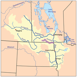
The Red River is a North American river. Originating at the confluence of the Bois de Sioux and Otter Tail rivers in the United States, it flows northward through the Red River Valley and forms the border between the U.S. states of Minnesota and North Dakota before continuing into Manitoba, Canada...
, approximately 319 miles (513.4 km) long, in southern Manitoba
Manitoba
Manitoba is a Canadian prairie province with an area of . The province has over 110,000 lakes and has a largely continental climate because of its flat topography. Agriculture, mostly concentrated in the fertile southern and western parts of the province, is vital to the province's economy; other...
in Canada
Canada
Canada is a North American country consisting of ten provinces and three territories. Located in the northern part of the continent, it extends from the Atlantic Ocean in the east to the Pacific Ocean in the west, and northward into the Arctic Ocean...
and northeastern North Dakota
North Dakota
North Dakota is a state located in the Midwestern region of the United States of America, along the Canadian border. The state is bordered by Canada to the north, Minnesota to the east, South Dakota to the south and Montana to the west. North Dakota is the 19th-largest state by area in the U.S....
in the United States
United States
The United States of America is a federal constitutional republic comprising fifty states and a federal district...
. It drains an area (about 8500 square kilometers) of the prairie
Prairie
Prairies are considered part of the temperate grasslands, savannas, and shrublands biome by ecologists, based on similar temperate climates, moderate rainfall, and grasses, herbs, and shrubs, rather than trees, as the dominant vegetation type...
country along the U.S.-Canada border, threading the Manitoba-North Dakota border eastward to the Red River. Via the Red River, Lake Winnipeg
Lake Winnipeg
Lake Winnipeg is a large, lake in central North America, in the province of Manitoba, Canada, with its southern tip about north of the city of Winnipeg...
and the Nelson River
Nelson River
The Nelson River is a river of north-central North America, in the Canadian province of Manitoba. Its full length is , it has mean discharge of , and has a drainage basin of , of which is in the United States...
, it is part of the watershed
Drainage basin
A drainage basin is an extent or an area of land where surface water from rain and melting snow or ice converges to a single point, usually the exit of the basin, where the waters join another waterbody, such as a river, lake, reservoir, estuary, wetland, sea, or ocean...
of Hudson Bay
Hudson Bay
Hudson Bay , sometimes called Hudson's Bay, is a large body of saltwater in northeastern Canada. It drains a very large area, about , that includes parts of Ontario, Quebec, Saskatchewan, Alberta, most of Manitoba, southeastern Nunavut, as well as parts of North Dakota, South Dakota, Minnesota,...
.
It rises in several streams on the eastern side of the Turtle Mountain
Turtle Mountain (plateau)
Turtle Mountain, or the Turtle Mountains, is an area in central North America, in the north-central portion of the U.S. state of North Dakota and southwestern portion of the Canadian province of Manitoba...
s on both sides of the international border. The streams converge near Neelin, Manitoba
Neelin, Manitoba
Neelin is a small community in the Canadian province of Manitoba. It is located on Manitoba Provincial Highway 5 in the Rural Municipality of Argyle, about 29 km east of Killarney, or about 200 km southwest of Winnipeg....
and flow initially northeast, then southeast along the west side of the Pembina Hills into Cavalier County
Cavalier County, North Dakota
-Major highways:* North Dakota Highway 1* North Dakota Highway 5* North Dakota Highway 20* North Dakota Highway 66-Demographics:As of the census of 2000, there were 4,831 people, 2,017 households, and 1,361 families residing in the county. The population density was 3 people per square mile...
in northeastern North Dakota. It flows east, just south of the border, past Walhalla
Walhalla, North Dakota
As of the census of 2000, there were 1,057 people, 452 households, and 271 families residing in the city. The population density was 1,004.4 people per square mile . There were 556 housing units at an average density of 528.3 per square mile . The racial makeup of the city was 89.78% White, 5.96%...
and Neche
Neche, North Dakota
As of the census of 2000, there were 437 people, 169 households, and 114 families residing in the city. The population density was 1,248.0 people per square mile . There were 188 housing units at an average density of 536.9 per square mile...
. It joins the Red River from the east at Pembina
Pembina, North Dakota
Pembina is a city in Pembina County, North Dakota in the United States. The population was 592 at the 2010 census.The area of Pembina was long inhabited by various indigenous peoples...
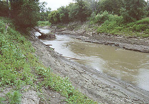
, approximately 2 miles (3 km) south of the international border. It receives the Tongue River
Tongue River (North Dakota)
The Tongue River is a tributary of the Pembina River in northeastern North Dakota in the United States. It drains an area of the prairie country near the Canadian border in the extreme northeast corner of the state in the watershed of the Red River....
from the south approximately 2 miles (3 km) upstream from its mouth on the Red.