
Assiniboine River
Encyclopedia
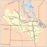
The Assiniboine River is a 1070 kilometres (664.9 mi) river
that runs through the prairie
s of Western Canada
in Saskatchewan
and Manitoba
. It is a tributary of the Red River
. The Assiniboine is a typical meandering river with a single main channel embanked within a flat, shallow valley in some places and a steep valley in others. Its main tributaries are the Qu'Appelle
and Souris
Rivers.
The river takes its name from the Assiniboine First Nation. Robert Douglas of the Geographical Board of Canada (1933) made several comments as to its origin: "The name commemorates the Assiniboine natives called by La Vérendrye in 1730 'Assiniboils' and by Governor Knight in 1715 of the Hudson's Bay Company
'stone Indians.' Assiniboine is the name of an Indian tribe and is derived from 'assine' a stone and 'bwan' native name of the Sioux, hence Stony Sioux name was possibly given because they used heated stones in cooking their food."
 The river rises near the community of Preeceville
in eastern Saskatchewan
and then meanders southeastward to "The Forks
" in Winnipeg, Manitoba where it flows into the Red River
.
Today, Assiniboine Herald
at the Canadian Heraldic Authority
is named after the river. Asessippi Provincial Park
, an RV park
was built on the east shore of the Shellmouth Reservoir.
Tributaries include the Whitesand River which joins it near Kamsack, Saskatchewan, the Souris River
which joins it near Wawanesa
, the Birdtail River which joins at the Birdtail Sioux First Nation
, the Little Saskatchewan which joins west of Brandon and the Qu'Appelle River
which joins near the site of historic Fort Ellice
.
 There are three hydrometric stations on the river that have been taking measurements since 1913. The Assiniboine River near Headingley
has an average discharge of 45 m3/s. One millimeter of runoff from half the watershed would take 70 hours to drain at flow rates of 360 m3/s. The following discharge rates were recorded during the 1995 flood:
It is prone to spring flooding. Some flood flows can be diverted into Lake Manitoba
at Portage la Prairie. In 1967, the Shellmouth Dam
was built in Shellmouth to help reduce flood peaks and to supplement flows during dry periods. The Portage Diversion
was completed in 1970. Despite these efforts, in May 2011 it was necessary to breech one of the dykes beside the river to relieve flood stresses east of Portage la Prairie. A Manitoba-wide state of emergency
was declared in the wake of one in three hundred-year floods on the Assiniboine River at Brandon
.
species include walleye
, yellow perch
, northern pike
, mooneye
, burbot
, Channel Catfish brown bullhead
, rock bass
, white sucker
, shorthead redhorse
and common carp
. Rock bass are Saskatchewan's only native bass.
River
A river is a natural watercourse, usually freshwater, flowing towards an ocean, a lake, a sea, or another river. In a few cases, a river simply flows into the ground or dries up completely before reaching another body of water. Small rivers may also be called by several other names, including...
that runs through the prairie
Prairie
Prairies are considered part of the temperate grasslands, savannas, and shrublands biome by ecologists, based on similar temperate climates, moderate rainfall, and grasses, herbs, and shrubs, rather than trees, as the dominant vegetation type...
s of Western Canada
Canada
Canada is a North American country consisting of ten provinces and three territories. Located in the northern part of the continent, it extends from the Atlantic Ocean in the east to the Pacific Ocean in the west, and northward into the Arctic Ocean...
in Saskatchewan
Saskatchewan
Saskatchewan is a prairie province in Canada, which has an area of . Saskatchewan is bordered on the west by Alberta, on the north by the Northwest Territories, on the east by Manitoba, and on the south by the U.S. states of Montana and North Dakota....
and Manitoba
Manitoba
Manitoba is a Canadian prairie province with an area of . The province has over 110,000 lakes and has a largely continental climate because of its flat topography. Agriculture, mostly concentrated in the fertile southern and western parts of the province, is vital to the province's economy; other...
. It is a tributary of the Red River
Red River of the North
The Red River is a North American river. Originating at the confluence of the Bois de Sioux and Otter Tail rivers in the United States, it flows northward through the Red River Valley and forms the border between the U.S. states of Minnesota and North Dakota before continuing into Manitoba, Canada...
. The Assiniboine is a typical meandering river with a single main channel embanked within a flat, shallow valley in some places and a steep valley in others. Its main tributaries are the Qu'Appelle
Qu'Appelle River
The Qu'Appelle River is a Canadian river that flows 430 km east from Lake Diefenbaker in southwestern Saskatchewan to join the Assiniboine River in Manitoba, just south of Lake of the Prairies, near the village of St. Lazare....
and Souris
Souris River
The Souris River or Mouse River is a river in central North America. It is about 700 km in length and drains about . It rises in the Yellow Grass Marshes north of Weyburn, Saskatchewan...
Rivers.
The river takes its name from the Assiniboine First Nation. Robert Douglas of the Geographical Board of Canada (1933) made several comments as to its origin: "The name commemorates the Assiniboine natives called by La Vérendrye in 1730 'Assiniboils' and by Governor Knight in 1715 of the Hudson's Bay Company
Hudson's Bay Company
The Hudson's Bay Company , abbreviated HBC, or "The Bay" is the oldest commercial corporation in North America and one of the oldest in the world. A fur trading business for much of its existence, today Hudson's Bay Company owns and operates retail stores throughout Canada...
'stone Indians.' Assiniboine is the name of an Indian tribe and is derived from 'assine' a stone and 'bwan' native name of the Sioux, hence Stony Sioux name was possibly given because they used heated stones in cooking their food."
Course
Preeceville, Saskatchewan
-Transportation:The community is served by Preeceville Airport which is located 1 nautical mile southeast.-External links:* http://www.townofpreeceville.ca* http://www.saskbiz.ca/communityprofiles/communityprofile.asp?CommunityID=314...
in eastern Saskatchewan
Saskatchewan
Saskatchewan is a prairie province in Canada, which has an area of . Saskatchewan is bordered on the west by Alberta, on the north by the Northwest Territories, on the east by Manitoba, and on the south by the U.S. states of Montana and North Dakota....
and then meanders southeastward to "The Forks
The Forks, Winnipeg, Manitoba
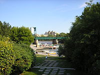
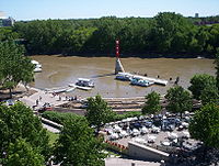
The Forks is a historic site and meeting place in Downtown Winnipeg located at the confluence of the Red River and Assiniboine River. For at least 6000 years, the Forks has been the meeting place for early Aboriginal peoples, and since colonization has also been a meeting place for European fur...
" in Winnipeg, Manitoba where it flows into the Red River
Red River of the North
The Red River is a North American river. Originating at the confluence of the Bois de Sioux and Otter Tail rivers in the United States, it flows northward through the Red River Valley and forms the border between the U.S. states of Minnesota and North Dakota before continuing into Manitoba, Canada...
.
Today, Assiniboine Herald
Assiniboine Herald
Assiniboine Herald of Arms is the title of one of the officers of arms at the Canadian Heraldic Authority in Ottawa. Like the other heralds at the Authority, the name is derived from the Canadian river of the same name...
at the Canadian Heraldic Authority
Canadian Heraldic Authority
The Canadian Heraldic Authority is part of the Canadian honours system under the Queen of Canada, whose authority is exercised by the Governor General. The Authority is responsible for the creation and granting of new coats of arms , flags and badges for Canadian citizens, permanent residents and...
is named after the river. Asessippi Provincial Park
Asessippi Provincial Park
Asessippi Provincial Park is a provincial park located in Manitoba, Canada about 100 km west of Dauphin. The Park is 23.2 km2 . The focal point is the Lake of the Prairies also known as Shellmouth Reservoir. The lake has one of the largest walleye fisheries in Manitoba...
, an RV park
RV park
A recreational vehicle park or caravan park is a place where people with recreational vehicles can stay overnight, or longer, in alloted spaces known as "pitches"...
was built on the east shore of the Shellmouth Reservoir.
Tributaries include the Whitesand River which joins it near Kamsack, Saskatchewan, the Souris River
Souris River
The Souris River or Mouse River is a river in central North America. It is about 700 km in length and drains about . It rises in the Yellow Grass Marshes north of Weyburn, Saskatchewan...
which joins it near Wawanesa
Wawanesa, Manitoba
Wawanesa is a community in Manitoba, Canada. It is the birthplace of the The Wawanesa Mutual Insurance Co. The village is surrounded by the Rural Municipality of Oakland....
, the Birdtail River which joins at the Birdtail Sioux First Nation
Birdtail Sioux First Nation
Birdtail Sioux First Nation are a Dakota, Sioux First Nation located approximately 50 km north of Virden, Manitoba. The first nation has a population of approximately 643 people on approximately of land. It is bordered by the Rural Municipality of Miniota and the Rural Municipality of Archie...
, the Little Saskatchewan which joins west of Brandon and the Qu'Appelle River
Qu'Appelle River
The Qu'Appelle River is a Canadian river that flows 430 km east from Lake Diefenbaker in southwestern Saskatchewan to join the Assiniboine River in Manitoba, just south of Lake of the Prairies, near the village of St. Lazare....
which joins near the site of historic Fort Ellice
Fort Ellice
Fort Ellice was a Hudson's Bay Company trading post built in 1831 in Rupert's Land near the junction of the Assiniboine and Qu'Appelle rivers. The fort was located in what is now west-central Manitoba, Canada, just east of that province's border with Saskatchewan.It was an important fort, as it was...
.
Flow rates and flood potential
Headingley, Manitoba
Headingley is a rural municipality in Manitoba, Canada. It is located directly west of Winnipeg and has a population of 2,726 people as of the 2006 census. The Trans-Canada Highway and the Assiniboine River run through the municipality. The portion located on the south bank of the Assiniboine is...
has an average discharge of 45 m3/s. One millimeter of runoff from half the watershed would take 70 hours to drain at flow rates of 360 m3/s. The following discharge rates were recorded during the 1995 flood:
| Location | Peak flow, 1995 (m3/s) |
Mean flow, April '95 (m3/s) |
Mean flow, May '95 (m3/s) |
Max flow, date (m3/s) |
|---|---|---|---|---|
| Russell | 360 May 4 |
34.2 | 46.3 | 504 April 29, 1922 |
| Brandon | 566 April 26 |
81.1 | 104.0 | 651 May 7, 1923 |
| Headingley | 300 April 20 |
115.0 | 142.0 | 614 April 27, 1916 |
It is prone to spring flooding. Some flood flows can be diverted into Lake Manitoba
Lake Manitoba
Lake Manitoba is Canada's thirteenth largest lake and the world's 33rd largest freshwater lake. It is in central North America, in the Canadian province of Manitoba, which is named after the lake...
at Portage la Prairie. In 1967, the Shellmouth Dam
Shellmouth Reservoir
The Shellmouth Reservoir is a man-made reservoir on the Assiniboine River in Manitoba and Saskatchewan, Canada.The Shellmouth Dam an embankment dam was built by the Prairie Farm Rehabilitation Administration . Construction started in 1964 and was completed in 1972 costing $10.8 million. The dam is ...
was built in Shellmouth to help reduce flood peaks and to supplement flows during dry periods. The Portage Diversion
Portage Diversion
The Portage Diversion is a water control structure on the Assiniboine River in Portage la Prairie, Manitoba, Canada. The project was made as part of a larger attempt to prevent flooding in the Red River Valley...
was completed in 1970. Despite these efforts, in May 2011 it was necessary to breech one of the dykes beside the river to relieve flood stresses east of Portage la Prairie. A Manitoba-wide state of emergency
State of emergency
A state of emergency is a governmental declaration that may suspend some normal functions of the executive, legislative and judicial powers, alert citizens to change their normal behaviours, or order government agencies to implement emergency preparedness plans. It can also be used as a rationale...
was declared in the wake of one in three hundred-year floods on the Assiniboine River at Brandon
Brandon, Manitoba
Brandon is the second largest city in Manitoba, Canada, and is located in the southwestern area of the province. Brandon is the largest city in the Westman region of Manitoba. The city is located along the Assiniboine River. Spruce Woods Provincial Park and CFB Shilo are a relatively short distance...
.
Fauna
FishFish
Fish are a paraphyletic group of organisms that consist of all gill-bearing aquatic vertebrate animals that lack limbs with digits. Included in this definition are the living hagfish, lampreys, and cartilaginous and bony fish, as well as various extinct related groups...
species include walleye
Walleye
Walleye is a freshwater perciform fish native to most of Canada and to the northern United States. It is a North American close relative of the European pikeperch...
, yellow perch
Yellow perch
The yellow perch is a species of perch found in the United States and Canada, where it is often referred to by the shortform perch. Yellow perch look similar to the European perch, but are paler and more yellowish, with less red in the fins. They have six to eight dark, vertical bars on their sides...
, northern pike
Northern Pike
The northern pike , is a species of carnivorous fish of the genus Esox...
, mooneye
Mooneye
The mooneyes are a family, the Hiodontidae, of primitive ray-finned fish comprising two living and three extinct species in the genus Hiodon. They are large-eyed, fork-tailed fish that physically resemble shads. Their common name comes from the metallic gold or silver shine of their eyes.The higher...
, burbot
Burbot
The burbot is the only gadiform fish inhabiting freshwaters. It is also known as mariah, the lawyer, and eelpout. It is closely related to the marine common ling and the cusk...
, Channel Catfish brown bullhead
Brown bullhead
The brown bullhead, Ameiurus nebulosus, is a fish of the Ictaluridae family that is widely distributed in North America. It is a species of bullhead catfish and is similar to the black bullhead and yellow bullhead...
, rock bass
Rock bass
The rock bass , also known as the rock perch, goggle-eye, or red eye is a species of freshwater fish in the sunfish family of order Perciformes. They are similar in appearance to smallmouth bass but are usually quite a bit smaller...
, white sucker
White Sucker
The White Sucker is a bottom-feeding freshwater fish inhabiting North America from Labrador in the north to Georgia and New Mexico in the south. It is a long, round-bodied fish with a dark green, grey, copper, brown, or black back and sides and a light underbelly. When fullgrown, it is between 12...
, shorthead redhorse
Shorthead redhorse
-Introduction:The Shorthead Redhorse is a wide-ranging species in North America that needs to be monitored throughout its range. The Shorthead Redhorse is native to central and eastern North America. However, its range has expanded to include areas like the Hudson estuary and Grayson County, Texas...
and common carp
Common carp
The Common carp is a widespread freshwater fish of eutrophic waters in lakes and large rivers in Europe and Asia. The wild populations are considered vulnerable to extinction, but the species has also been domesticated and introduced into environments worldwide, and is often considered an invasive...
. Rock bass are Saskatchewan's only native bass.
See also
External links
- http://www.publications.gov.sk.ca/details.cfm?p=11115 Fish Species of Saskatchewan
- http://esask.uregina.ca/entry/assiniboine_river.html Encyclopedia of Saskatchewan