
Mid-October 2007 tornado outbreak
Encyclopedia
The Mid-October 2007 tornado outbreak was a widespread tornado outbreak
that took place across much of the eastern half of North America
starting on October 18, 2007 and continuing into the early hours of October 19. The outbreak was also responsible for five deaths; three in Michigan
and two in Missouri
, plus many injuries (including some from non-tornadic events). At least 64 tornado
es were confirmed including 16 on October 17 across six states including Texas
, Oklahoma
, Arkansas
, Louisiana
, Mississippi
and Missouri
with wind damage reported in Oklahoma
, Kansas
, Illinois
, Iowa
, Arkansas
and Mississippi
. On October 18, at least 48 tornadoes were confirmed across eight states including Florida
, Alabama
, Mississippi
, Tennessee
, Kentucky
, Illinois
, Indiana
and Michigan
, plus widespread straight line wind damage. It was the largest tornado outbreak ever recorded in the month of October according to NOAA
.
 A deep low pressure system (with a pressure of 977 mbar at its peak) moved across the Pacific Coast
on October 15 and then crossed the Rockies
during the following day and touched out some moist air from the Gulf of Mexico
, major source for storm development and intensification. Not part of the main outbreak, 3 tornadoes were reported, during the overnight hours of October 16 towards October 17, across Randall County, Texas south of Amarillo
on October 16 with 1 of them confirmed as a high EF1. That tornado caused damage to trees, fences, power poles, steel pipes, trailers and barns.
The next day a dry line
, which separates the drier air from the more moist and humid air, formed ahead of the cold front across the Texas
and Oklahoma Panhandle
s and tracked eastward. The high humidity levels with dew points in the 70s°F (low 20s°C), temperatures that in many areas were near 80°F (27°C), strong wind shear and the presence of the dry line helped developed the instability to produced severe thunderstorms across the Midwest and Southern Plains on October 17.
A moderate risk for severe weather was issued by the Storm Prediction Center
two days prior to the event. The storm then moved across the most of the Midwest on October 18, where a moderate risk was in effect also for two days for most of Illinois
, Indiana
and parts of Kentucky
, although the moderate risk was revised further to the south and east to include western Ohio
, western Tennessee, southeastern Missouri, northeastern Arkansas and a larger portion of Kentucky while Michigan and Wisconsin
were no longer under a moderate risk. A slight risk of severe weather was forecast for a very large area from beyond the Canadian border to the Florida Panhandle and Mobile Bay
. Dew points above 70°F (21°C) were reported well into the Ohio Valley, and dew points above 60°F (16°C) were reported as far north as northern Ontario.
The outbreak was expected to continue into October 19 east of the Appalachians, however, extensive cloud cover prevented any significant severe storms from developing although several wind reports were reported in Pennsylvania
, New Jersey
and Massachusetts
. The storm then moved out into the Atlantic Ocean
on October 20.
 The first severe thunderstorms developed during the early morning of October 17 across much of northern and eastern Texas and parts of Oklahoma and Kansas with only one reported tornado in east Texas. Several severe thunderstorms then later developed across eastern Oklahoma, Arkansas, Louisiana, western Mississippi, eastern Kansas, Missouri and parts of Nebraska
, Iowa, Kentucky
, Illinois and Tennessee
. Twelve additional tornadoes were reported in Missouri and Louisiana during the late afternoon and early evening with damage reported in Lawrence and Greene counties in Missouri. One of the tornadoes located near Verona
destroyed several barns and homes but did not cause any injuries and was later confirmed as an EF2. The storms persisted throughout the night and an additional tornado killed 2 people inside a mobile home in Greene County, Missouri
near Paris.
 On October 18, several thunderstorms already developed during the morning hours and continued to intensify during the afternoon. Just after 11:00 am EDT, one tornado in downtown Pensacola, Florida
caused some extensive damage to the roof of a Baptist church as well as portions of Cordova Mall
but there were no reported injuries at the Church and daycare center. During the early evenings severe weather affected the Louisville, Kentucky
Metro area in which tree damage and power outage were reported throughout the area and a possible tornado at around 7:00 pm EDT near the Crescent Hill area which was later confirmed as a brief EF0. Still in the region, one tree fell over a passing car but the motorist escaped injuries even he was trapped for several minutes inside. The Louisville power authority, the LG&E reported as much as 2,500 homes without power mostly in St. Matthews
and Crescent Hill areas. More storms rolled through much of the Ohio and Tennessee Valleys during the second half of the evening and overnight with more storms in Michigan.
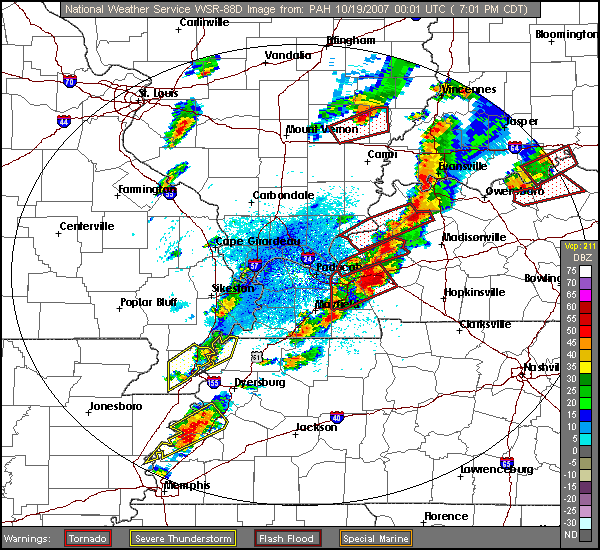 Areas the hardest hit were along and near the Ohio River
in western Kentucky as well as central and northern Indiana in Nappanee
where injuries were reported as well as significant damage, and in Central Michigan. Three people were killed overall on October 18: one in Kalkaska County, Michigan
and two in Locke Township, near Williamston, Michigan
. In addition to the tornadoes, storm straight line damaging wind measured up to 80 mph (130 km/h) were recorded across several of the regions hit by the severe weather, causing extensive tree and power line with isolated reports of structural damage.
In Michigan, a tornado in Tuscola
near Flint
threw a one year old baby 40 feet (12.2 m) away from its location along with the crib and was later found amongst a pile of rubble under a mattress. His parents told reporters that the mattress saved the toddler's life and he suffered few to no injuries.
According to the National Weather Service in Detroit, tornadoes this late in the year in Michigan are very rare. The last significant October tornado event was on October 24, 2001, when three tornadoes hit southeastern Lower Michigan, out of a total of nine in the state that day. Including the 2001 tornadoes, only seven October tornadoes had been recorded in the NWS Detroit county warning area prior to the 2007 outbreak. By comparison, NWS Detroit had confirmed five tornadoes in its coverage area from this outbreak. It was also the largest October outbreak over western Kentucky and southern Indiana as 15 tornadoes were confirmed on October 18. Previous to this outbreak, only 19 tornadoes had been recorded in that same region during the history of October prior to this event. The Owensboro
tornado, which was rated an EF3 was also the strongest ever in that month over the same region since records were kept in 1950 although an unofficial F3 took place in Posey County, Indiana
on October 16, 1928.
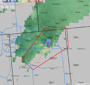
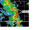 In addition to the tornadoes, widespread straight-line wind damage took place across much of the affected region, particularly on the night of October 17 as a result of a derecho
that moved across the southern Great Plains
into the Ozarks. Winds were reported as high as 100 mph (160 km/h) as a result of the bow echo
that moved across the region. Tulsa
was hard hit, with at least 55 people injured (one critically) due to wind damage at the Oktoberfest
event. Many mobile homes were destroyed, and widespread power outages were reported in the region including in Rogers County
near Oologah
where five people where injured. In Kansas, a bow echo caused some localized significant damage in and around the Wichita
Metropolitan Area with the most significant damage at the International Cold Storage located in the Andover
area where the peak winds were measured. Overall, over 400 wind reports in the US alone, were reported on both October 17 and 18 across the Midwest, Gulf Coast and Great Lakes with several reports of damage but there were no direct non-tornadic fatalities. In Chicago, an eleven year old boy was struck and injured by lightning while another person was injured by broken glass when high winds blew up windows of a lobby hall of a condominium.
In addition, the Gulf Coast region, particularly the Florida Panhandle
, received torrential rain due to continuous thunderstorms ahead of the cold front. Rainfall amounts over 12 inches (300 mm) were common (with amounts as high as 22 inches (560 mm) were reported in Gulf Breeze, Florida
), although only minor flooding was reported including roads and some houses flooded.
Tornado outbreak
While there is no single agreed upon definition, generally at least 6-10 tornadoes produced by the same synoptic scale weather system is considered a tornado outbreak. The tornadoes usually occur within the same day, or continue into the early morning hours of the succeeding day, and within the...
that took place across much of the eastern half of North America
North America
North America is a continent wholly within the Northern Hemisphere and almost wholly within the Western Hemisphere. It is also considered a northern subcontinent of the Americas...
starting on October 18, 2007 and continuing into the early hours of October 19. The outbreak was also responsible for five deaths; three in Michigan
Michigan
Michigan is a U.S. state located in the Great Lakes Region of the United States of America. The name Michigan is the French form of the Ojibwa word mishigamaa, meaning "large water" or "large lake"....
and two in Missouri
Missouri
Missouri is a US state located in the Midwestern United States, bordered by Iowa, Illinois, Kentucky, Tennessee, Arkansas, Oklahoma, Kansas and Nebraska. With a 2010 population of 5,988,927, Missouri is the 18th most populous state in the nation and the fifth most populous in the Midwest. It...
, plus many injuries (including some from non-tornadic events). At least 64 tornado
Tornado
A tornado is a violent, dangerous, rotating column of air that is in contact with both the surface of the earth and a cumulonimbus cloud or, in rare cases, the base of a cumulus cloud. They are often referred to as a twister or a cyclone, although the word cyclone is used in meteorology in a wider...
es were confirmed including 16 on October 17 across six states including Texas
Texas
Texas is the second largest U.S. state by both area and population, and the largest state by area in the contiguous United States.The name, based on the Caddo word "Tejas" meaning "friends" or "allies", was applied by the Spanish to the Caddo themselves and to the region of their settlement in...
, Oklahoma
Oklahoma
Oklahoma is a state located in the South Central region of the United States of America. With an estimated 3,751,351 residents as of the 2010 census and a land area of 68,667 square miles , Oklahoma is the 28th most populous and 20th-largest state...
, Arkansas
Arkansas
Arkansas is a state located in the southern region of the United States. Its name is an Algonquian name of the Quapaw Indians. Arkansas shares borders with six states , and its eastern border is largely defined by the Mississippi River...
, Louisiana
Louisiana
Louisiana is a state located in the southern region of the United States of America. Its capital is Baton Rouge and largest city is New Orleans. Louisiana is the only state in the U.S. with political subdivisions termed parishes, which are local governments equivalent to counties...
, Mississippi
Mississippi
Mississippi is a U.S. state located in the Southern United States. Jackson is the state capital and largest city. The name of the state derives from the Mississippi River, which flows along its western boundary, whose name comes from the Ojibwe word misi-ziibi...
and Missouri
Missouri
Missouri is a US state located in the Midwestern United States, bordered by Iowa, Illinois, Kentucky, Tennessee, Arkansas, Oklahoma, Kansas and Nebraska. With a 2010 population of 5,988,927, Missouri is the 18th most populous state in the nation and the fifth most populous in the Midwest. It...
with wind damage reported in Oklahoma
Oklahoma
Oklahoma is a state located in the South Central region of the United States of America. With an estimated 3,751,351 residents as of the 2010 census and a land area of 68,667 square miles , Oklahoma is the 28th most populous and 20th-largest state...
, Kansas
Kansas
Kansas is a US state located in the Midwestern United States. It is named after the Kansas River which flows through it, which in turn was named after the Kansa Native American tribe, which inhabited the area. The tribe's name is often said to mean "people of the wind" or "people of the south...
, Illinois
Illinois
Illinois is the fifth-most populous state of the United States of America, and is often noted for being a microcosm of the entire country. With Chicago in the northeast, small industrial cities and great agricultural productivity in central and northern Illinois, and natural resources like coal,...
, Iowa
Iowa
Iowa is a state located in the Midwestern United States, an area often referred to as the "American Heartland". It derives its name from the Ioway people, one of the many American Indian tribes that occupied the state at the time of European exploration. Iowa was a part of the French colony of New...
, Arkansas
Arkansas
Arkansas is a state located in the southern region of the United States. Its name is an Algonquian name of the Quapaw Indians. Arkansas shares borders with six states , and its eastern border is largely defined by the Mississippi River...
and Mississippi
Mississippi
Mississippi is a U.S. state located in the Southern United States. Jackson is the state capital and largest city. The name of the state derives from the Mississippi River, which flows along its western boundary, whose name comes from the Ojibwe word misi-ziibi...
. On October 18, at least 48 tornadoes were confirmed across eight states including Florida
Florida
Florida is a state in the southeastern United States, located on the nation's Atlantic and Gulf coasts. It is bordered to the west by the Gulf of Mexico, to the north by Alabama and Georgia and to the east by the Atlantic Ocean. With a population of 18,801,310 as measured by the 2010 census, it...
, Alabama
Alabama
Alabama is a state located in the southeastern region of the United States. It is bordered by Tennessee to the north, Georgia to the east, Florida and the Gulf of Mexico to the south, and Mississippi to the west. Alabama ranks 30th in total land area and ranks second in the size of its inland...
, Mississippi
Mississippi
Mississippi is a U.S. state located in the Southern United States. Jackson is the state capital and largest city. The name of the state derives from the Mississippi River, which flows along its western boundary, whose name comes from the Ojibwe word misi-ziibi...
, Tennessee
Tennessee
Tennessee is a U.S. state located in the Southeastern United States. It has a population of 6,346,105, making it the nation's 17th-largest state by population, and covers , making it the 36th-largest by total land area...
, Kentucky
Kentucky
The Commonwealth of Kentucky is a state located in the East Central United States of America. As classified by the United States Census Bureau, Kentucky is a Southern state, more specifically in the East South Central region. Kentucky is one of four U.S. states constituted as a commonwealth...
, Illinois
Illinois
Illinois is the fifth-most populous state of the United States of America, and is often noted for being a microcosm of the entire country. With Chicago in the northeast, small industrial cities and great agricultural productivity in central and northern Illinois, and natural resources like coal,...
, Indiana
Indiana
Indiana is a US state, admitted to the United States as the 19th on December 11, 1816. It is located in the Midwestern United States and Great Lakes Region. With 6,483,802 residents, the state is ranked 15th in population and 16th in population density. Indiana is ranked 38th in land area and is...
and Michigan
Michigan
Michigan is a U.S. state located in the Great Lakes Region of the United States of America. The name Michigan is the French form of the Ojibwa word mishigamaa, meaning "large water" or "large lake"....
, plus widespread straight line wind damage. It was the largest tornado outbreak ever recorded in the month of October according to NOAA
National Oceanic and Atmospheric Administration
The National Oceanic and Atmospheric Administration , pronounced , like "noah", is a scientific agency within the United States Department of Commerce focused on the conditions of the oceans and the atmosphere...
.
Meteorological synopsis
Pacific Coast
A country's Pacific coast is the part of its coast bordering the Pacific Ocean.-The Americas:Countries on the western side of the Americas have a Pacific coast as their western border.* Geography of Canada* Geography of Chile* Geography of Colombia...
on October 15 and then crossed the Rockies
Rocky Mountains
The Rocky Mountains are a major mountain range in western North America. The Rocky Mountains stretch more than from the northernmost part of British Columbia, in western Canada, to New Mexico, in the southwestern United States...
during the following day and touched out some moist air from the Gulf of Mexico
Gulf of Mexico
The Gulf of Mexico is a partially landlocked ocean basin largely surrounded by the North American continent and the island of Cuba. It is bounded on the northeast, north and northwest by the Gulf Coast of the United States, on the southwest and south by Mexico, and on the southeast by Cuba. In...
, major source for storm development and intensification. Not part of the main outbreak, 3 tornadoes were reported, during the overnight hours of October 16 towards October 17, across Randall County, Texas south of Amarillo
Amarillo, Texas
Amarillo is the 14th-largest city, by population, in the state of Texas, the largest in the Texas Panhandle, and the seat of Potter County. A portion of the city extends into Randall County. The population was 190,695 at the 2010 census...
on October 16 with 1 of them confirmed as a high EF1. That tornado caused damage to trees, fences, power poles, steel pipes, trailers and barns.
The next day a dry line
Dry line
A dry line separates moist air from the Gulf of Mexico and dry desert air from the south-western states . The dry line is an important factor in severe weather frequency in the Great Plains of North America...
, which separates the drier air from the more moist and humid air, formed ahead of the cold front across the Texas
Texas Panhandle
The Texas Panhandle is a region of the U.S. state of Texas consisting of the northernmost 26 counties in the state. The panhandle is a rectangular area bordered by New Mexico to the west and Oklahoma to the north and east...
and Oklahoma Panhandle
Oklahoma Panhandle
The Oklahoma Panhandle is the extreme western region of the state of Oklahoma, comprising Cimarron County, Texas County, and Beaver County. Its name comes from the similarity of shape to the handle of a cooking pan....
s and tracked eastward. The high humidity levels with dew points in the 70s°F (low 20s°C), temperatures that in many areas were near 80°F (27°C), strong wind shear and the presence of the dry line helped developed the instability to produced severe thunderstorms across the Midwest and Southern Plains on October 17.
A moderate risk for severe weather was issued by the Storm Prediction Center
Storm Prediction Center
The Storm Prediction Center , located in Norman, Oklahoma, is tasked with forecasting the risk of severe thunderstorms and tornadoes in the contiguous United States. The agency issues convective outlooks, mesoscale discussions, and watches as a part of this process...
two days prior to the event. The storm then moved across the most of the Midwest on October 18, where a moderate risk was in effect also for two days for most of Illinois
Illinois
Illinois is the fifth-most populous state of the United States of America, and is often noted for being a microcosm of the entire country. With Chicago in the northeast, small industrial cities and great agricultural productivity in central and northern Illinois, and natural resources like coal,...
, Indiana
Indiana
Indiana is a US state, admitted to the United States as the 19th on December 11, 1816. It is located in the Midwestern United States and Great Lakes Region. With 6,483,802 residents, the state is ranked 15th in population and 16th in population density. Indiana is ranked 38th in land area and is...
and parts of Kentucky
Kentucky
The Commonwealth of Kentucky is a state located in the East Central United States of America. As classified by the United States Census Bureau, Kentucky is a Southern state, more specifically in the East South Central region. Kentucky is one of four U.S. states constituted as a commonwealth...
, although the moderate risk was revised further to the south and east to include western Ohio
Ohio
Ohio is a Midwestern state in the United States. The 34th largest state by area in the U.S.,it is the 7th‑most populous with over 11.5 million residents, containing several major American cities and seven metropolitan areas with populations of 500,000 or more.The state's capital is Columbus...
, western Tennessee, southeastern Missouri, northeastern Arkansas and a larger portion of Kentucky while Michigan and Wisconsin
Wisconsin
Wisconsin is a U.S. state located in the north-central United States and is part of the Midwest. It is bordered by Minnesota to the west, Iowa to the southwest, Illinois to the south, Lake Michigan to the east, Michigan to the northeast, and Lake Superior to the north. Wisconsin's capital is...
were no longer under a moderate risk. A slight risk of severe weather was forecast for a very large area from beyond the Canadian border to the Florida Panhandle and Mobile Bay
Mobile Bay
Mobile Bay is an inlet of the Gulf of Mexico, lying within the state of Alabama in the United States. Its mouth is formed by the Fort Morgan Peninsula on the eastern side and Dauphin Island, a barrier island on the western side. The Mobile River and Tensaw River empty into the northern end of the...
. Dew points above 70°F (21°C) were reported well into the Ohio Valley, and dew points above 60°F (16°C) were reported as far north as northern Ontario.
The outbreak was expected to continue into October 19 east of the Appalachians, however, extensive cloud cover prevented any significant severe storms from developing although several wind reports were reported in Pennsylvania
Pennsylvania
The Commonwealth of Pennsylvania is a U.S. state that is located in the Northeastern and Mid-Atlantic regions of the United States. The state borders Delaware and Maryland to the south, West Virginia to the southwest, Ohio to the west, New York and Ontario, Canada, to the north, and New Jersey to...
, New Jersey
New Jersey
New Jersey is a state in the Northeastern and Middle Atlantic regions of the United States. , its population was 8,791,894. It is bordered on the north and east by the state of New York, on the southeast and south by the Atlantic Ocean, on the west by Pennsylvania and on the southwest by Delaware...
and Massachusetts
Massachusetts
The Commonwealth of Massachusetts is a state in the New England region of the northeastern United States of America. It is bordered by Rhode Island and Connecticut to the south, New York to the west, and Vermont and New Hampshire to the north; at its east lies the Atlantic Ocean. As of the 2010...
. The storm then moved out into the Atlantic Ocean
Atlantic Ocean
The Atlantic Ocean is the second-largest of the world's oceanic divisions. With a total area of about , it covers approximately 20% of the Earth's surface and about 26% of its water surface area...
on October 20.
Significant tornadoes
Nebraska
Nebraska is a state on the Great Plains of the Midwestern United States. The state's capital is Lincoln and its largest city is Omaha, on the Missouri River....
, Iowa, Kentucky
Kentucky
The Commonwealth of Kentucky is a state located in the East Central United States of America. As classified by the United States Census Bureau, Kentucky is a Southern state, more specifically in the East South Central region. Kentucky is one of four U.S. states constituted as a commonwealth...
, Illinois and Tennessee
Tennessee
Tennessee is a U.S. state located in the Southeastern United States. It has a population of 6,346,105, making it the nation's 17th-largest state by population, and covers , making it the 36th-largest by total land area...
. Twelve additional tornadoes were reported in Missouri and Louisiana during the late afternoon and early evening with damage reported in Lawrence and Greene counties in Missouri. One of the tornadoes located near Verona
Verona, Missouri
Verona is a city in Lawrence County, Missouri, United States. The population was 714 at the 2000 census, at which time it was a town.-Geography:Verona is located at ....
destroyed several barns and homes but did not cause any injuries and was later confirmed as an EF2. The storms persisted throughout the night and an additional tornado killed 2 people inside a mobile home in Greene County, Missouri
Greene County, Missouri
Greene County is a county located in Southwest Missouri. As of 2010, the population was 275,174 making it the fourth most populated county in Missouri. Its county seat is Springfield...
near Paris.
Pensacola, Florida
Pensacola is the westernmost city in the Florida Panhandle and the county seat of Escambia County, Florida, United States of America. As of the 2000 census, the city had a total population of 56,255 and as of 2009, the estimated population was 53,752...
caused some extensive damage to the roof of a Baptist church as well as portions of Cordova Mall
Cordova Mall
Cordova Mall, located in Pensacola, Florida, is the largest shopping center on the northwest Gulf Coast of Florida. It is currently owned and managed by Simon Property Group....
but there were no reported injuries at the Church and daycare center. During the early evenings severe weather affected the Louisville, Kentucky
Louisville, Kentucky
Louisville is the largest city in the U.S. state of Kentucky, and the county seat of Jefferson County. Since 2003, the city's borders have been coterminous with those of the county because of a city-county merger. The city's population at the 2010 census was 741,096...
Metro area in which tree damage and power outage were reported throughout the area and a possible tornado at around 7:00 pm EDT near the Crescent Hill area which was later confirmed as a brief EF0. Still in the region, one tree fell over a passing car but the motorist escaped injuries even he was trapped for several minutes inside. The Louisville power authority, the LG&E reported as much as 2,500 homes without power mostly in St. Matthews
St. Matthews, Kentucky
St. Matthews is the 20th largest city in Kentucky, United States and is a prominent suburb of Louisville. It is located 8 miles east of downtown Louisville in Jefferson County. It is one of the state's major shopping areas, being home to second and fifth largest malls in Kentucky St. Matthews is...
and Crescent Hill areas. More storms rolled through much of the Ohio and Tennessee Valleys during the second half of the evening and overnight with more storms in Michigan.
Ohio River
The Ohio River is the largest tributary, by volume, of the Mississippi River. At the confluence, the Ohio is even bigger than the Mississippi and, thus, is hydrologically the main stream of the whole river system, including the Allegheny River further upstream...
in western Kentucky as well as central and northern Indiana in Nappanee
Nappanee, Indiana
-Demographics:As of the census of 2000, there were 6,710 people, 2,521 households, and 1,792 families residing in the city. The population density was 1,818.9 people per square mile . There were 2,647 housing units at an average density of 717.5 per square mile...
where injuries were reported as well as significant damage, and in Central Michigan. Three people were killed overall on October 18: one in Kalkaska County, Michigan
Kalkaska County, Michigan
-Demographics:As of the census of 2000, there were 16,571 people, 6,428 households, and 4,634 families residing in the county. The population density was 30 people per square mile . There were 10,822 housing units at an average density of 19 per square mile...
and two in Locke Township, near Williamston, Michigan
Williamston, Michigan
Williamston is a city in Ingham County in the U.S. state of Michigan. The city is at the southeast corner of Williamstown Township, but is politically independent. A portion of Williamston was annexed from adjacent Wheatfield Township. Downtown Williamston is located at the intersection of Grand...
. In addition to the tornadoes, storm straight line damaging wind measured up to 80 mph (130 km/h) were recorded across several of the regions hit by the severe weather, causing extensive tree and power line with isolated reports of structural damage.
In Michigan, a tornado in Tuscola
Tuscola County, Michigan
-Highways:* M-15* M-24* M-25* M-46* M-81* M-138-Demographics:As of the census of 2000, there were 58,266 people, 21,454 households, and 15,983 families residing in the county. The population density was 72 people per square mile . There were 23,378 housing units at an average density of 29 per...
near Flint
Flint, Michigan
Flint is a city in the U.S. state of Michigan and is located along the Flint River, northwest of Detroit. The U.S. Census Bureau reports the 2010 population to be placed at 102,434, making Flint the seventh largest city in Michigan. It is the county seat of Genesee County which lies in the...
threw a one year old baby 40 feet (12.2 m) away from its location along with the crib and was later found amongst a pile of rubble under a mattress. His parents told reporters that the mattress saved the toddler's life and he suffered few to no injuries.
According to the National Weather Service in Detroit, tornadoes this late in the year in Michigan are very rare. The last significant October tornado event was on October 24, 2001, when three tornadoes hit southeastern Lower Michigan, out of a total of nine in the state that day. Including the 2001 tornadoes, only seven October tornadoes had been recorded in the NWS Detroit county warning area prior to the 2007 outbreak. By comparison, NWS Detroit had confirmed five tornadoes in its coverage area from this outbreak. It was also the largest October outbreak over western Kentucky and southern Indiana as 15 tornadoes were confirmed on October 18. Previous to this outbreak, only 19 tornadoes had been recorded in that same region during the history of October prior to this event. The Owensboro
Owensboro, Kentucky
Owensboro is the fourth largest city by population in the U.S. state of Kentucky. It is the county seat of Daviess County. It is located on U.S. Route 60 about southeast of Evansville, Indiana, and is the principal city of the Owensboro, Kentucky, Metropolitan Statistical Area. The city's...
tornado, which was rated an EF3 was also the strongest ever in that month over the same region since records were kept in 1950 although an unofficial F3 took place in Posey County, Indiana
Posey County, Indiana
As of the census of 2000, there were 27,061 people, 10,205 households, and 7,612 families residing in the county. The population density was 66 people per square mile . There were 11,076 housing units at an average density of 27 per square mile...
on October 16, 1928.
Tornadoes confirmed
October 17 event
| List of reported tornadoes - Wednesday, October 17, 2007 | ||||||
|---|---|---|---|---|---|---|
Fujita scale The Fujita scale , or Fujita-Pearson scale, is a scale for rating tornado intensity, based primarily on the damage tornadoes inflict on human-built structures and vegetation... |
|
|
|
|
|
|
| Texas Texas Texas is the second largest U.S. state by both area and population, and the largest state by area in the contiguous United States.The name, based on the Caddo word "Tejas" meaning "friends" or "allies", was applied by the Spanish to the Caddo themselves and to the region of their settlement in... |
||||||
| EF1 | W of Ogg | Randall | 0516 | 11 miles (17.6 km) |
Damage to several barns, fencing, a trailer, a homestead and power poles. Two large diesel tanks were also moved. | |
| EF0 | SW of Buna | Jasper | 1532 | 1 miles (1.6 km) |
Brief touchdown with damage to trees | |
| Missouri Missouri Missouri is a US state located in the Midwestern United States, bordered by Iowa, Illinois, Kentucky, Tennessee, Arkansas, Oklahoma, Kansas and Nebraska. With a 2010 population of 5,988,927, Missouri is the 18th most populous state in the nation and the fifth most populous in the Midwest. It... |
||||||
| EF0 | W of Centerview Centerview, Missouri Centerview is a city in Johnson County, Missouri, United States. The population was 249 at the 2000 census.-Geography:Centerview is located at .... |
Johnson Johnson County, Missouri Johnson County is a county located in the U.S. state of Missouri. As of 2010, the population was 52,595. Its county seat is Warrensburg. The county was formed 13 December 1834 from Lafayette County and was named for Vice President Richard M... |
2105 | unknown | Brief touchdown with no damage | |
| EF2 | N of Verona Verona, Missouri Verona is a city in Lawrence County, Missouri, United States. The population was 714 at the 2000 census, at which time it was a town.-Geography:Verona is located at .... |
Lawrence | 2250 | 11 miles (17 km) |
Intermittent damage path. Nine houses damaged or destroyed, along with a lumber mill and several barns. | |
| EF1 | N of Cave Springs | Greene Greene County, Missouri Greene County is a county located in Southwest Missouri. As of 2010, the population was 275,174 making it the fourth most populated county in Missouri. Its county seat is Springfield... |
2335 | 3 miles (4.8 km) |
Two houses and a barn were damaged or destroyed. | |
| EF0 | S of Lebanon Lebanon, Missouri Lebanon is a city in Laclede County, Missouri, United States. The estimated population in July 2009 was 14,292. The population was 12,155 at the 2000 census. It is the county seat of Laclede County. The Lebanon Micropolitan Statistical Area consists of Laclede County.-Geography:Lebanon is located at... |
Laclede Laclede County, Missouri Laclede County is a county located in the U.S. state of Missouri. As of 2000, the population was 32,513. Its county seat is Lebanon. The county was organized February 24, 1849, and was named after Pierre Laclède, founder of St... |
0435 | unknown | Damage reported to a mobile home and the roof of a house. | |
| EF0 | E of Hatton | Callaway Callaway County, Missouri Callaway County is a county located in the U.S. state of Missouri. It is part of the Jefferson City, Missouri Metropolitan Statistical Area. As of 2010, the population was 44,332. Its county seat is Fulton. The county was organized in 1820. It was named for Capt. James Callaway, a grandson of... |
0455 | 1 miles (1.6 km) |
A horse stable, a double wide mobile home, a large garage and trees were damaged | |
| EF0 | S of Madison Madison, Missouri Madison is a city in Monroe County, Missouri, United States. The population was 586 at the 2000 census.-Geography:Madison is located at .According to the United States Census Bureau, the city has a total area of , all of it land.... |
Monroe | 0500 | 4 miles (6.4 km) |
Two machine sheds were damaged as the tornado tracked across mostly farmland. | |
| EF2 | NW of Paris Paris, Missouri Paris is a city in Monroe County, Missouri, United States. The population was 1,529 at the 2000 census. It is the county seat of Monroe County.-Geography:Paris is located at... |
Monroe | 0505 | 4 miles (6.4 km) |
2 deaths - A mobile home was thrown, killing its occupants. A large barn and machine shed were also destroyed. | |
| EF0 | N of Paris Paris, Missouri Paris is a city in Monroe County, Missouri, United States. The population was 1,529 at the 2000 census. It is the county seat of Monroe County.-Geography:Paris is located at... |
Monroe | 0507 | 2 miles (3.2 km) |
Damage to trees and a machine shed. | |
| Oklahoma Oklahoma Oklahoma is a state located in the South Central region of the United States of America. With an estimated 3,751,351 residents as of the 2010 census and a land area of 68,667 square miles , Oklahoma is the 28th most populous and 20th-largest state... |
||||||
| EF0 | NE of Fort Tawson | Choctaw Choctaw County, Oklahoma Choctaw County is a county located in the U.S. state of Oklahoma. As of 2000, the population was 15,342. Its county seat is Hugo.-Geography:According to the U.S. Census Bureau, the county has a total area of , of which is land and is water.... |
2214 | unknown | Brief tornado over open country with no damage | |
| Louisiana Louisiana Louisiana is a state located in the southern region of the United States of America. Its capital is Baton Rouge and largest city is New Orleans. Louisiana is the only state in the U.S. with political subdivisions termed parishes, which are local governments equivalent to counties... |
||||||
| EF1 | Franklinton Franklinton, Louisiana Franklinton is a town in and the parish seat of Washington Parish, Louisiana, United States. The population was 3,657 at the 2000 census. It is an average of above sea level.... |
Washington Washington Parish, Louisiana Washington Parish is a parish located in the U.S. state of Louisiana. Its parish seat is Franklinton. In 2000, its population was 43,926.... |
2245 | unknown | Three windows suffered window and roof damage | |
| EF1 | N of Franklinton Franklinton, Louisiana Franklinton is a town in and the parish seat of Washington Parish, Louisiana, United States. The population was 3,657 at the 2000 census. It is an average of above sea level.... |
Washington Washington Parish, Louisiana Washington Parish is a parish located in the U.S. state of Louisiana. Its parish seat is Franklinton. In 2000, its population was 43,926.... |
2255 | unknown | A mobile home had roof damage and several trees were uprooted | |
| Arkansas Arkansas Arkansas is a state located in the southern region of the United States. Its name is an Algonquian name of the Quapaw Indians. Arkansas shares borders with six states , and its eastern border is largely defined by the Mississippi River... |
||||||
| EF1 | W of Star City Star City, Arkansas Star City is a city in and the county seat of Lincoln County, Arkansas, United States. The population was 2,471 at the 2000 census. It is included in the 'Pine Bluff Metropolitan Statistical Area'.-Geography:... |
Lincoln Lincoln County, Arkansas Lincoln County is a county located in the U.S. state of Arkansas and is included in the Pine Bluff Metropolitan Statistical Area. As of 2010, the population is 14,134. The county seat is Star City. Lincoln County is Arkansas's 65th county, formed on March 28, 1871, and named for Abraham Lincoln,... |
2302 | 5.4 miles (8.6 km) |
Six mobile homes were damaged or destroyed and four houses sustained minor damage. Widespread tree and power line damage. | |
| Mississippi Mississippi Mississippi is a U.S. state located in the Southern United States. Jackson is the state capital and largest city. The name of the state derives from the Mississippi River, which flows along its western boundary, whose name comes from the Ojibwe word misi-ziibi... |
||||||
| EF1 | NE of Society Hill | Jefferson Davis Jefferson Davis County, Mississippi -Demographics:As of the census of 2000, there were 13,962 people, 5,177 households, and 3,768 families residing in the county. The population density was 34 people per square mile . There were 5,891 housing units at an average density of 14 per square mile... |
0030 | 0.33 mile (550 m) |
One house and two storage buildings lost their roofs. | |
| EF1 | N of Hattiesburg Hattiesburg, Mississippi Hattiesburg is a city in Forrest County, Mississippi, United States. The population was 44,779 at the 2000 census . It is the county seat of Forrest County... |
Forrest Forrest County, Mississippi The median income for a household in the county was $27,420, and the median income for a family was $35,791. Males had a median income of $28,742 versus $20,500 for females. The per capita income for the county was $15,160... |
0110 | 1.5 miles (2.4 km) |
Tornado began at Exit 69 on I-59, where a car was blown off injuring the occupant. Roof damage was reported to two houses and a garage. | |
| EF0 | Tolarville Tolarville, Mississippi Tolarville is an unincorporated community located in Holmes County, Mississippi. Tolarville is approximately east of Thornton and approximately north of Coxburg.... area |
Holmes Holmes County, Mississippi -National protected areas:*Hillside National Wildlife Refuge *Mathews Brake National Wildlife Refuge *Morgan Brake National Wildlife Refuge*Theodore Roosevelt National Wildlife Refuge -Demographics:... |
0303 | 2 miles (3.2 km) |
Several trees were downed | |
| Sources: Storm reports of October 17, 2007 NWS Springfield, NWS St. Louis, NWS Little Rock, NWS Jackson MS, NOAA Storm Data |
||||||
October 18 event
| List of reported tornadoes - Thursday, October 18, 2007 | ||||||
|---|---|---|---|---|---|---|
Fujita scale The Fujita scale , or Fujita-Pearson scale, is a scale for rating tornado intensity, based primarily on the damage tornadoes inflict on human-built structures and vegetation... |
|
|
|
|
|
|
| Mississippi Mississippi Mississippi is a U.S. state located in the Southern United States. Jackson is the state capital and largest city. The name of the state derives from the Mississippi River, which flows along its western boundary, whose name comes from the Ojibwe word misi-ziibi... |
||||||
| EF1 | W of Vancleave Vancleave, Mississippi Vancleave is a census-designated place in Jackson County, Mississippi, United States. It is part of the Pascagoula, Mississippi Metropolitan Statistical Area... |
Jackson Jackson County, Mississippi There were 47,676 households out of which 37.00% had children under the age of 18 living with them, 55.70% were married couples living together, 14.50% had a female householder with no husband present, and 25.10% were non-families. 20.80% of all households were made up of individuals and 7.10% had... |
1045 | 1.8 miles (3 km) |
Two mobile homes were destroyed, along with numerous outbuildings. Heavy tree and power line damage. | |
| EF0 | Starkville Starkville, Mississippi -Demographics:As of the census of 2000, there were 21,869 people, 9,462 households, and 4,721 families residing in the city. The population density was 851.4 people per square mile . There were 10,191 housing units at an average density of 396.7 per square mile... |
Oktibbeha Oktibbeha County, Mississippi -National protected areas:*Noxubee National Wildlife Refuge *Tombigbee National Forest -Demographics:As of the census of 2000, there were 42,902 people, 15,945 households, and 9,264 families residing in the county. The population density was 94 people per square mile . There were 17,344 housing... |
1741 | 0.1 mile (160 m) |
Brief tornado, minor damage to a building at the Starkville Country Club. | |
| EF0 | E of Starkville Starkville, Mississippi -Demographics:As of the census of 2000, there were 21,869 people, 9,462 households, and 4,721 families residing in the city. The population density was 851.4 people per square mile . There were 10,191 housing units at an average density of 396.7 per square mile... |
Oktibbeha Oktibbeha County, Mississippi -National protected areas:*Noxubee National Wildlife Refuge *Tombigbee National Forest -Demographics:As of the census of 2000, there were 42,902 people, 15,945 households, and 9,264 families residing in the county. The population density was 94 people per square mile . There were 17,344 housing... |
1804 | unknown | Tornado touchdown recorded in an open field. No significant damage. | |
| EF1 | N of De Kalb De Kalb, Mississippi De Kalb is a town in Kemper County, Mississippi, United States. The population was 972 at the 2000 census. It is the county seat of Kemper County.-Geography:De Kalb is located at .... |
Kemper Kemper County, Mississippi -Demographics:As of the census of 2000, there were 10,453 people, 3,909 households, and 2,787 families residing in the county. The population density was 14 people per square mile . There were 4,533 housing units at an average density of 6 per square mile... , Noxubee Noxubee County, Mississippi -Demographics:As of the census of 2000, there were 12,548 people, 4,470 households, and 3,222 families residing in the county. The population density was 18 people per square mile . There were 5,228 housing units at an average density of 8 per square mile... |
1913 | 3 miles (4.8 km) |
Damage limited to pine trees being knocked down. | |
| EF0 | SE of Thornton Thornton, Mississippi Thornton is an unincorporated community located in Holmes County, Mississippi. Thornton is located on U.S. Highway 49E and is approximately north of Eden and approximately south of Tchula.... |
Holmes Holmes County, Mississippi -National protected areas:*Hillside National Wildlife Refuge *Mathews Brake National Wildlife Refuge *Morgan Brake National Wildlife Refuge*Theodore Roosevelt National Wildlife Refuge -Demographics:... |
0208 | 2 miles (3.2 km) |
Narrow path of tree damage. | |
| Florida Florida Florida is a state in the southeastern United States, located on the nation's Atlantic and Gulf coasts. It is bordered to the west by the Gulf of Mexico, to the north by Alabama and Georgia and to the east by the Atlantic Ocean. With a population of 18,801,310 as measured by the 2010 census, it... |
||||||
| EF1 | Pensacola Pensacola, Florida Pensacola is the westernmost city in the Florida Panhandle and the county seat of Escambia County, Florida, United States of America. As of the 2000 census, the city had a total population of 56,255 and as of 2009, the estimated population was 53,752... |
Escambia Escambia County, Florida Escambia County is the westernmost county in the U.S. state of Florida. The 2010 population was 297,619. The U.S. Census Bureau 2005 estimate for the county is 296,772. Its county seat is Pensacola.- History :... |
1513 | 7 miles (11 km) |
Tornado first touched down near Pensacola Naval Station, also tracking through downtown Pensacola and a commercial area, especially Cordova Mall Cordova Mall Cordova Mall, located in Pensacola, Florida, is the largest shopping center on the northwest Gulf Coast of Florida. It is currently owned and managed by Simon Property Group.... . 86 buildings were damaged by the tornado. Four people were injured. |
|
| Alabama Alabama Alabama is a state located in the southeastern region of the United States. It is bordered by Tennessee to the north, Georgia to the east, Florida and the Gulf of Mexico to the south, and Mississippi to the west. Alabama ranks 30th in total land area and ranks second in the size of its inland... |
||||||
| EF0 | NW of Vernon Vernon, Alabama Vernon is a city in Lamar County, Alabama, United States. At the 2000 census the population was 2,143. The city is the county seat of Lamar County.- Geography :Vernon is located at .According to the U.S... |
Lamar Lamar County, Alabama Lamar County is a county of the U.S. state of Alabama. Its name is in honor of Lucius Quintus Cincinnatus Lamar, member of the United States Senate from Mississippi. As of 2010 the population was 14,564... |
1815 | unknown | Brief tornado touchdown photographed by police. The tornado did not caused any damage. | |
| EF0 | SW of Haleyville Haleyville, Alabama Haleyville is a city in Winston and Marion counties in the U.S. state of Alabama. Most of the city is located in Winston County, with a small portion of the western limits entering Marion County. Haleyville was originally named Davis Cross Roads, having been established at the crossroads of Byler... |
Marion Marion County, Alabama Marion County is a county of the U.S. state of Alabama. Marion County was created by an act of the Alabama Territorial General Assembly on February 13, 1818. The county is located in the northwestern part of the state, bounded on the west by the state of Mississippi. It encompasses . Marion County... |
1951 | 0.06 mile (100 m) |
A farmhouse was damaged, and tree and powerline damage was reported. | |
| EF1 | NE of Haleyville Haleyville, Alabama Haleyville is a city in Winston and Marion counties in the U.S. state of Alabama. Most of the city is located in Winston County, with a small portion of the western limits entering Marion County. Haleyville was originally named Davis Cross Roads, having been established at the crossroads of Byler... |
Lawrence Lawrence County, Alabama Lawrence County is a county of the U.S. state of Alabama, and is included in the Decatur Metropolitan Area, as well as the Huntsville-Decatur Combined Statistical Area. It was named after James Lawrence, a captain in the United States Navy from New Jersey. As of the 2010 census, the population was... |
2005 | 0.15 mile (250 m) |
Tornado reported in the Bankhead National Forest, damaging trees. | |
| Michigan Michigan Michigan is a U.S. state located in the Great Lakes Region of the United States of America. The name Michigan is the French form of the Ojibwa word mishigamaa, meaning "large water" or "large lake".... |
||||||
| EF1 | W of Tower | Cheboygan Cheboygan County, Michigan -Commercial Airline:There are no commercial airline airports in Cheboygan County but the nearest ones are Alpena County Regional Airport, Chippewa County International Airport , and Cherry Capital Airport... |
2125 | 10 miles (16 km) |
Damage reported near Black Lake Black Lake (Michigan) Black Lake is located in Cheboygan and Presque Isle counties in Northern Michigan. With a surface area of 10,130 acres , it is the seventh largest inland lake in Michigan. The largest body of water in the Black River watershed, it drains through the Lower Black and Cheboygan Rivers into Lake Huron... , including a barn destroyed. |
|
| EF2 | NE of Long Rapids | Alpena Alpena County, Michigan Alpena County is a county in the U.S. state of Michigan. As of the 2010 census, the population was 29,598. The county seat is Alpena. It is considered to be part of Northern Michigan.It was founded originally in 1840 as Anomickee County... |
2225 | 4 miles (6.4 km) |
Three houses were damaged, and three barns and a shed were destroyed. Significant tree damage also reported. | |
| EF2 | SW of Kalkaska Kalkaska, Michigan Kalkaska is a village in the U.S. state of Michigan. As of the 2000 census, the village population was 2,226. It is the county seat of Kalkaska County.-Geography:... |
Kalkaska Kalkaska County, Michigan -Demographics:As of the census of 2000, there were 16,571 people, 6,428 households, and 4,634 families residing in the county. The population density was 30 people per square mile . There were 10,822 housing units at an average density of 19 per square mile... |
2335 | 5 miles (8 km) |
1 death - Numerous houses were damaged or destroyed, including a mobile home where the fatality occurred. Severe damage also reported at the Kalkaska County Airport. | |
| EF2 | E of Luzerne | Oscoda Oscoda County, Michigan See also: List of counties bordering eight counties-Demographics:As of the census of 2000, there were 9,418 people, 3,921 households, and 2,717 families residing in the county. The population density was 17 people per square mile . There were 8,690 housing units at an average density of 15 per... |
0012 | 14 miles (22 km) |
Large wedge tornado damaged 15 houses. Hundreds of trees were snapped or uprooted. | |
| EF1 | E of Luzerne | Oscoda Oscoda County, Michigan See also: List of counties bordering eight counties-Demographics:As of the census of 2000, there were 9,418 people, 3,921 households, and 2,717 families residing in the county. The population density was 17 people per square mile . There were 8,690 housing units at an average density of 15 per... , Alcona Alcona County, Michigan Alcona County is a county of the U.S. state of Michigan. As of the 2000 census, the population is 11,719. Its county seat is Harrisville. Alphabetically it is the first county in Michigan, as its flag states "First of the 83".-History:... |
0042 | 3 miles (4.8 km) |
Considerable tree damage. Related to Luzerne tornado. | |
| EF2 | N of Hubbard Lake | Alpena Alpena County, Michigan Alpena County is a county in the U.S. state of Michigan. As of the 2010 census, the population was 29,598. The county seat is Alpena. It is considered to be part of Northern Michigan.It was founded originally in 1840 as Anomickee County... |
0100 | 0.25 mile (400 m) |
One house was heavily damaged and two barns and a mobile home were destroyed. | |
| EF2 | SE of Williamston Williamston, Michigan Williamston is a city in Ingham County in the U.S. state of Michigan. The city is at the southeast corner of Williamstown Township, but is politically independent. A portion of Williamston was annexed from adjacent Wheatfield Township. Downtown Williamston is located at the intersection of Grand... |
Ingham Ingham County, Michigan -Demographics:As of the census of 2000, there were 279,320 people, 108,593 households, and 63,744 families residing in the county. The population density was 500 people per square mile . There were 115,056 housing units at an average density of 206 per square mile... , Shiawassee Shiawassee County, Michigan -Transportation:-Demographics:As of the census of 2000, there were 71,687 people, 26,896 households, and 19,849 families residing in the county. The population density was 133 people per square mile . There were 29,087 housing units at an average density of 54 per square mile... |
0228 | 19 miles (30.4 km) |
2 deaths - Two people were found the following morning after they being thrown out of their modular home into a nearby pond. A tractor-trailer was thrown on I-96. | |
| EF1 | SSW of Millington Millington, Michigan Millington is a village in Tuscola County in the U.S. state of Michigan. The population was 1,137 at the 2000 census. The village is located within Millington Township.... |
Tuscola Tuscola County, Michigan -Highways:* M-15* M-24* M-25* M-46* M-81* M-138-Demographics:As of the census of 2000, there were 58,266 people, 21,454 households, and 15,983 families residing in the county. The population density was 72 people per square mile . There were 23,378 housing units at an average density of 29 per... |
0515 | 2 miles (3.2 km) |
Reported by law enforcement. According to the Associated Press Associated Press The Associated Press is an American news agency. The AP is a cooperative owned by its contributing newspapers, radio and television stations in the United States, which both contribute stories to the AP and use material written by its staff journalists... , a year-old baby inside his crib was thrown 40 feet (12.2 m) by the tornado but escaped injuries in Millington Township Millington Township, Michigan Millington Township is a civil township of Tuscola County in the U.S. state of Michigan. The population was 4,459 at the 2000 census. The Village of Millington is located within the township.-Geography:... . |
|
| EF0 | E of Clio Clio, Michigan Clio is a city in Genesee County in the U.S. state of Michigan.As of the 2000 census, the city had a population of 2,483. Clio is home to Michigan's second tallest construction, the WEYI Tower... |
Genesee Genesee County, Michigan -Interstates:* I-69* I-75* I-475-Michigan State Trunklines:* M-13* M-15* M-21* M-54* M-57-Demographics:As of the census of 2000, there were 436,141 people, 169,825 households, and 115,990 families residing in the county. The population density was 682 people per square mile . There were 183,630... |
0516 | 2.5 miles (4 km) |
Shingle damage to one home | |
| EF1 | W of Deford Wells Township, Tuscola County, Michigan Wells Township is a civil township of Tuscola County in the U.S. state of Michigan. The population was 1,946 at the 2000 census.-Communities:*There are no incorporated municipalities in the township.... |
Tuscola Tuscola County, Michigan -Highways:* M-15* M-24* M-25* M-46* M-81* M-138-Demographics:As of the census of 2000, there were 58,266 people, 21,454 households, and 15,983 families residing in the county. The population density was 72 people per square mile . There were 23,378 housing units at an average density of 29 per... |
0545 | 3 miles (4.8 km) |
SPC Storm Reports web page listed tornado twice; second listing was erroneous duplication of report with incorrect location; NWS Detroit damage survey report and storm report list does not include duplicate report. | |
| EF1 | W of Port Hope Port Hope, Michigan Port Hope is a village in Huron County of the U.S. state of Michigan. As of the 2000 census, the village population was 310. The village is within Rubicon Township.-Geography:... |
Huron Huron County, Michigan -Highways:* M-19* M-25* M-53* M-142-Demographics:As of the census of 2000, there were 36,079 people, 14,597 households, and 10,144 families residing in the county. The population density was 43 people per square mile . There were 20,430 housing units at an average density of 24 per square mile... |
0630 | 1 mile (1.6 km) |
Substantial damage to farm buildings, heavy farm machinery lifted and displaced. Not listed in preliminary reports, but found during damage surveys. | |
| Illinois Illinois Illinois is the fifth-most populous state of the United States of America, and is often noted for being a microcosm of the entire country. With Chicago in the northeast, small industrial cities and great agricultural productivity in central and northern Illinois, and natural resources like coal,... |
||||||
| EF0 | NE of West Salem West Salem, Illinois West Salem is a village in Edwards County, Illinois, United States. The population was 1,001 at the 2000 census.-Earthquake:West Salem is within the Wabash Valley seismic zone. On April 18, 2008 at 09:36:56 UTC a moderate earthquake of 5.2 magnitude was centered near the village... |
Edwards Edwards County, Illinois Edwards County is a county located in the U.S. state of Illinois. According to the 2010 census, it has a population of 6,721, which is a decrease of 3.6% from 6,971 in 2000... |
2215 | unknown | Brief touchdown according to trained spotters and several officials. No damage was found. | |
| Kentucky Kentucky The Commonwealth of Kentucky is a state located in the East Central United States of America. As classified by the United States Census Bureau, Kentucky is a Southern state, more specifically in the East South Central region. Kentucky is one of four U.S. states constituted as a commonwealth... |
||||||
| EF1 | NE of Owensboro Owensboro, Kentucky Owensboro is the fourth largest city by population in the U.S. state of Kentucky. It is the county seat of Daviess County. It is located on U.S. Route 60 about southeast of Evansville, Indiana, and is the principal city of the Owensboro, Kentucky, Metropolitan Statistical Area. The city's... |
Daviess Daviess County, Kentucky As of the census of 2000, there were 91,545 people, 36,033 households, and 24,826 families residing in the county. The population density was . There were 38,432 housing units at an average density of... |
2307 | 2 miles (3.2 km) |
A few structures were damaged. | |
| EF0 | Louisville Louisville, Kentucky Louisville is the largest city in the U.S. state of Kentucky, and the county seat of Jefferson County. Since 2003, the city's borders have been coterminous with those of the county because of a city-county merger. The city's population at the 2010 census was 741,096... |
Jefferson Jefferson County, Kentucky As of the census of 2000, there were 693,604 people, 287,012 households, and 183,113 families residing in the county. The population density was . There were 305,835 housing units at an average density of... |
2310 | unknown | Tornado touched down at a Kroger Kroger The Kroger Co. is an American supermarket chain founded by Bernard Kroger in 1883 in Cincinnati, Ohio. It reported US$ 76.7 billion in sales during fiscal year 2009. It is the country's largest grocery store chain and its second-largest grocery retailer by volume and second-place general retailer... store in the Crescent Hill Crescent Hill, Louisville Crescent Hill is a neighborhood four miles east of downtown Louisville, Kentucky USA. Area was originally called "Beargrass" because it sits on a ridge between two forks of Beargrass Creek.... area. Damage limited to that commercial structure. |
|
| EF2 | S of Lewisport Lewisport, Kentucky Lewisport is a city in Hancock County, Kentucky, United States, along the Ohio River. The population was 1639 at the 2000 census. It is included in the Owensboro, Kentucky Metropolitan Statistical Area.Founded in 1839, Lewisport is named for an early settler.... |
Daviess Daviess County, Kentucky As of the census of 2000, there were 91,545 people, 36,033 households, and 24,826 families residing in the county. The population density was . There were 38,432 housing units at an average density of... , Hancock Hancock County, Kentucky Hancock County is a county located in the U.S. state of Kentucky. It was formed in 1829. As of 2000, the population was 8,392. It is included in the Owensboro, Kentucky, Metropolitan Statistical Area. Its county seat is Hawesville. The county is named for John Hancock... |
2310 | 13.2 miles (21 km) |
Long track tornado with multiple touchdowns. Numerous trees and several buildings damaged. | |
| EF0 | SW of Gatewood | Daviess Daviess County, Kentucky As of the census of 2000, there were 91,545 people, 36,033 households, and 24,826 families residing in the county. The population density was . There were 38,432 housing units at an average density of... |
2315 | 1 miles (1.6 km) |
Several trees were damaged | |
| EF2 | Sebree Sebree, Kentucky Sebree is a city in Webster County, Kentucky, United States. The population was 1,558 at the 2000 census. In 1868, a town was founded by William Scott and Colonel E. G. Sebree of Trenton, Kentucky. The L & N Railroad was begun in 1850 but was not completed until after the American Civil War... area |
Webster Webster County, Kentucky Webster County is a county located in the U.S. state of Kentucky. Webster County was formed in 1860 from parts of the counties of Henderson, Hopkins, and Union. As of 2000, the population is 14,120. Its county seat is Dixon. The county was named for American statesman Daniel Webster... |
0009 | 10.4 miles (16.5 km) |
Major damage reported inside the city limits, including numerous houses damaged or destroyed. | |
| EF1 | E of Creswell | Caldwell Caldwell County, Kentucky As of the census of 2010, there were 12,984 people, with 6,292 households in the county.-Communities:*Bakers*Baldwin Ford*Black Hawk*The Bluff*Cedar Bluff*Claxton*Cobb*Cresswell*Crider*Crowtown*Enon*Farmersville*Flat Rock*Friendship*Fryer... |
0020 | unknown | Trees uprooted and snapped | |
| EF2 | S of Dawson Springs Dawson Springs, Kentucky Dawson Springs is a city in Caldwell and Hopkins counties in the Commonwealth of Kentucky. The population was 2,980 at the 2000 census. It is the birthplace of current governor of Kentucky, Steve L. Beshear. From the late 1800s to the 1930s, Dawson Springs was well known as a spa and resort town... |
Caldwell Caldwell County, Kentucky As of the census of 2010, there were 12,984 people, with 6,292 households in the county.-Communities:*Bakers*Baldwin Ford*Black Hawk*The Bluff*Cedar Bluff*Claxton*Cobb*Cresswell*Crider*Crowtown*Enon*Farmersville*Flat Rock*Friendship*Fryer... |
0025 | unknown | Roof damage to several houses and several barns destroyed. Some uprooted trees fell on houses. | |
| EF2 | SW of Owensboro Owensboro, Kentucky Owensboro is the fourth largest city by population in the U.S. state of Kentucky. It is the county seat of Daviess County. It is located on U.S. Route 60 about southeast of Evansville, Indiana, and is the principal city of the Owensboro, Kentucky, Metropolitan Statistical Area. The city's... |
McLean McLean County, Kentucky McLean County is a county located in the U.S. state of Kentucky; its population was 9,938 in the 2000 Census. McLean County's county seat is at Calhoun.... , Daviess Daviess County, Kentucky As of the census of 2000, there were 91,545 people, 36,033 households, and 24,826 families residing in the county. The population density was . There were 38,432 housing units at an average density of... |
0032 | 17.5 miles (28 km) |
Many houses damaged or destroyed. | |
| EF2 | SE of Dawson Springs Dawson Springs, Kentucky Dawson Springs is a city in Caldwell and Hopkins counties in the Commonwealth of Kentucky. The population was 2,980 at the 2000 census. It is the birthplace of current governor of Kentucky, Steve L. Beshear. From the late 1800s to the 1930s, Dawson Springs was well known as a spa and resort town... |
Christian Christian County, Kentucky Christian County is a county located in the U.S. state of Kentucky. It was formed in 1797. As of 2000, its population was 72,265. Its county seat is Hopkinsville, Kentucky... |
0040 | 2 miles (3.2 km) |
Widespread tree damage reported in the Pennyrile State Forest Pennyrile State Forest Pennyrile State Forest is a United States state forest in Christian County, Kentucky. It contains Pennyrile Forest State Resort Park and borders Lake Beshear. it is managed for sustainable timber production.-External links:*... . One mobile home was damaged on Highway 109. |
|
| EF2 | E of Dawson Springs Dawson Springs, Kentucky Dawson Springs is a city in Caldwell and Hopkins counties in the Commonwealth of Kentucky. The population was 2,980 at the 2000 census. It is the birthplace of current governor of Kentucky, Steve L. Beshear. From the late 1800s to the 1930s, Dawson Springs was well known as a spa and resort town... |
Hopkins Hopkins County, Kentucky Hopkins County is a county located in the U.S. state of Kentucky. It was formed in 1807. As of 2000, the population was 46,519. Its county seat is Madisonville. The county is named for General Samuel Hopkins, an officer in both the Revolutionary War and War of 1812, and later a Kentucky legislator... |
0050 | 1.5 miles (2.4 km) |
Three mobile homes were destroyed. One house and several barns were damaged, partially by flying debris. | |
| EF1 | Nortonville Nortonville, Kentucky Nortonville is a city in Hopkins County, Kentucky, United States. The population was 1,264 at the 2000 census.-Geography:Nortonville is located at .... |
Hopkins Hopkins County, Kentucky Hopkins County is a county located in the U.S. state of Kentucky. It was formed in 1807. As of 2000, the population was 46,519. Its county seat is Madisonville. The county is named for General Samuel Hopkins, an officer in both the Revolutionary War and War of 1812, and later a Kentucky legislator... |
0100 | 2 miles (3.2 km) |
Damage to several buildings in town, including two houses and a gas station. Widespread tree damage. | |
| EF1 | Blue Spring | Trigg Trigg County, Kentucky Trigg County is a county located in the U.S. state of Kentucky. It was formed in 1820. As of 2000, the population was 12,597. Its county seat is Cadiz. The county is named for Stephen Trigg, a frontier officer in the American Revolutionary War who died in the Battle of Blue Licks... |
0102 | 2.5 miles (4 km) |
Damage reported near Lake Barkley State Park to a house, cabin, garage and boat dock (some of the damage due to fallen trees). | |
| EF1 | NW of Hamlin | Calloway Calloway County, Kentucky Calloway County is a county located in the U.S. state of Kentucky. It was formed in 1823. As of 2010, the population was 37,191. Its county seat is Murray, Kentucky. The county is named for Colonel Richard Callaway, one of the founders of Boonesborough... |
0107 | 7.4 miles (12 km) |
Late report. One house heavily damaged primarily from fallen trees. | |
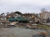
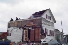
| EF3 | Owensboro Owensboro, Kentucky Owensboro is the fourth largest city by population in the U.S. state of Kentucky. It is the county seat of Daviess County. It is located on U.S. Route 60 about southeast of Evansville, Indiana, and is the principal city of the Owensboro, Kentucky, Metropolitan Statistical Area. The city's... area |
Daviess Daviess County, Kentucky As of the census of 2000, there were 91,545 people, 36,033 households, and 24,826 families residing in the county. The population density was . There were 38,432 housing units at an average density of... |
0109 | 7.5 miles (12 km) |
Major damage in the city with many houses and businesses damaged or destroyed. Eight people were injured. | |
| EF0 | SW of Linton | Trigg Trigg County, Kentucky Trigg County is a county located in the U.S. state of Kentucky. It was formed in 1820. As of 2000, the population was 12,597. Its county seat is Cadiz. The county is named for Stephen Trigg, a frontier officer in the American Revolutionary War who died in the Battle of Blue Licks... |
0123 | 1 mile (1.6 km) |
Damage to trees in the Land Between the Lakes area. No structures affected. | |
| EF2 | S of Cadiz Cadiz, Kentucky Cadiz is a city in Trigg County, Kentucky, United States. The population was 2,373 at the 2000 census. It is the county seat of Trigg County. It is an old town located close to the Land Between the Lakes, a popular recreation area, and was a base of Union and Confederate operations in the American... |
Trigg Trigg County, Kentucky Trigg County is a county located in the U.S. state of Kentucky. It was formed in 1820. As of 2000, the population was 12,597. Its county seat is Cadiz. The county is named for Stephen Trigg, a frontier officer in the American Revolutionary War who died in the Battle of Blue Licks... |
0132 | 10.5 miles (17 km) |
Two barns destroyed and debris thrown up to 3/4 mile (1.2 km) away. Many trees blown down. | |
| EF2 | Rosetta | Breckinridge Breckinridge County, Kentucky As of the census of 2000, there were 18,648 people, 7,324 households, and 5,309 families residing in the county. The population density was . There were 9,890 housing units at an average density of... |
0226 | 3 miles (4.8 km) |
A church was destroyed, and several houses suffered heavy damage. Three large vehicles were thrown into the air. | |
| EF1 | Fort Knox | Meade Meade County, Kentucky As of the census of 2000, there were 26,349 people, 9,470 households, and 7,396 families residing in the county. The population density was . There were 10,293 housing units at an average density of... |
0250 | 2.5 miles (4 km) |
Many trees were uprooted and twisted. Two businesses sustained roof damage. | |
| EF1 | Hubers area | Bullitt Bullitt County, Kentucky As of the census of 2000, there were 61,236 people, 22,171 households, and 17,736 families residing in the county. The population density was . There were 23,160 housing units at an average density of... |
0320 | 2 miles (3.2 km) |
Significant damage to outbuildings, sheds, two houses and one garage. | |
| EF0 | Bradfordsville Bradfordsville, Kentucky Bradfordsville is a city in Marion County, Kentucky, United States. The population was 304 at the 2000 census.-Geography:Bradfordsville is located at .... |
Marion Marion County, Kentucky As of the census of 2000, there were 18,212 people, 6,613 households, and 4,754 families residing in the county. The population density was . There were 7,277 housing units at an average density of... |
0636 | 0.5 mile (800 m) |
One mobile home was rolled over and several houses lost shingles. | |
| Indiana Indiana Indiana is a US state, admitted to the United States as the 19th on December 11, 1816. It is located in the Midwestern United States and Great Lakes Region. With 6,483,802 residents, the state is ranked 15th in population and 16th in population density. Indiana is ranked 38th in land area and is... |
||||||
| EF1 | NE of Cannelton Cannelton, Indiana Cannelton is a city in Troy Township, Perry County, Indiana, United States, along the Ohio River. The population was 1,209 at the 2000 census. Cannelton, which is the smallest incorporated city in the state, was formerly the county seat of Perry County until the seat was relocated to Tell City... |
Perry Perry County, Indiana Perry County is a county located in the southwestern part of the U.S. state of Indiana. As of 2010, the population was 19,338. The county seat is Tell City. It is the hilliest county as well as one of the most forested counties of in Indiana as it features more than of Hoosier National Forest... |
2334 | 5 miles (8 km) |
Minor damage mostly in the Cann Heights Road area. Originally considered a continuation of the Hancock County, KY tornado but reclassified as two separate tornadoes. | |
| EF0 | N of Ambia Ambia, Indiana Ambia is a town in Hickory Grove Township, Benton County, Indiana, United States. The population was 239 at the 2010 census. It is part of the Lafayette, Indiana Metropolitan Statistical Area.-History:... |
Benton Benton County, Indiana Benton County is located along in the northwest part of the U.S. state of Indiana, along the border with Illinois. As of 2010, the county's population was 8,854. It contains six incorporated towns as well as several small unincorporated settlements; it is also divided into 11 townships which... |
0035 | unknown | Brief touchdown in an open field with no damage | |
| EF1 | SE of St. Marks | Dubois Dubois County, Indiana Dubois County is a county located in the U.S. state of Indiana. The county seat is Jasper. As of 2010, the population was 41,889.Dubois County is part of the Jasper Micropolitan Statistical Area.-History:... |
0127 | 2 miles (3.2 km) |
A door from a house was blown off and a barn was damaged. About 100 trees were snapped. | |
| EF3 | New Washington New Washington, Indiana New Washington is a census-designated place in Clark County, Indiana, United States. As of the 2000 census, the CDP population was 547.-Geography:New Washington is located at .... |
Clark Clark County, Indiana Clark County is a county located in the U.S. state of Indiana, located directly across the Ohio River from Louisville, Kentucky. At the 2010 Census, the population was 110,232. The county seat is Jeffersonville. Clarksville is also a major city in the county... |
0203 | 4.8 miles (7.7 km) |
One house was completely destroyed and 10 houses were damaged, some heavily. Numerous barns and outbuildings were destroyed. Initially rated as an EF2 before further surveys in New Washington discovered low-end EF3 damage. | |
| EF3 | Nappanee Nappanee, Indiana -Demographics:As of the census of 2000, there were 6,710 people, 2,521 households, and 1,792 families residing in the city. The population density was 1,818.9 people per square mile . There were 2,647 housing units at an average density of 717.5 per square mile... area |
Marshall Marshall County, Indiana As of the census of 2000, there were 45,128 people, 16,519 households, and 12,191 families residing in the county. The population density was 102 people per square mile . There were 18,099 housing units at an average density of 41 per square mile... , Kosciusko Kosciusko County, Indiana Kosciusko County is a county located in the U.S. state of Indiana. Census 2010 recorded the population at 77,358. The county seat is Warsaw.The county was formed in 1836. It was named after the Polish general Tadeusz Kościuszko, who served in the American Revolutionary War, and then returned to... , Elkhart Elkhart County, Indiana Elkhart County is a county in the U.S. state of Indiana. Much of the county is in the Elkhart-Goshen Metropolitan Statistical Area, which in turn is part of the South Bend-Elkhart-Mishawaka Combined Statistical Area... |
0218 | 20 miles (32 km) |
Severe damage took place in the area. 591 buildings (including at least 368 homes and 81 businesses) were damaged, of which at least 98 were destroyed across the three counties. Some of the heavily damaged buildings were three RV Recreational vehicle Recreational vehicle or RV is, in North America, the usual term for a Motor vehicle or trailer equipped with living space and amenities found in a home.-Features:... factories and numerous fast food outlets. Significant damage was also reported to many farms, with barns blown down and outbuildings destroyed, and farm animals were killed. Eight people were injured.Damages were estimated between $25–35 million. |
|
| Tennessee Tennessee Tennessee is a U.S. state located in the Southeastern United States. It has a population of 6,346,105, making it the nation's 17th-largest state by population, and covers , making it the 36th-largest by total land area... |
||||||
| EF1 | W of Model | Stewart | 0118 | 1 miles (1.6 km) |
Numerous trees snapped and uprooted. | |
| Sources: Storm reports of October 18, 2007 NWS Michigan Offices (Combined report) NWS Northern Indiana summary, NWS Louisville summary NWS Central Illinois summary NWS Chicago summary NWS Paducah storm reports NWS Paducah summary NWS Tulsa summary NOAA Storm Data |
||||||
Nontornadic events
Derecho
A derecho is a widespread and long-lived, violent convectively induced straight-line windstorm that is associated with a fast-moving band of severe thunderstorms in the form of a squall line usually taking the form of a bow echo...
that moved across the southern Great Plains
Great Plains
The Great Plains are a broad expanse of flat land, much of it covered in prairie, steppe and grassland, which lies west of the Mississippi River and east of the Rocky Mountains in the United States and Canada. This area covers parts of the U.S...
into the Ozarks. Winds were reported as high as 100 mph (160 km/h) as a result of the bow echo
Bow echo
A bow echo is a term describing the characteristic radar return from a mesoscale convective system that is shaped like an archer’s bow. These systems can produce severe straight-line winds and occasionally tornadoes, causing major damage.-Research:...
that moved across the region. Tulsa
Tulsa, Oklahoma
Tulsa is the second-largest city in the state of Oklahoma and 46th-largest city in the United States. With a population of 391,906 as of the 2010 census, it is the principal municipality of the Tulsa Metropolitan Area, a region with 937,478 residents in the MSA and 988,454 in the CSA. Tulsa's...
was hard hit, with at least 55 people injured (one critically) due to wind damage at the Oktoberfest
Oktoberfest celebrations
The Oktoberfest is a two-week festival held each year in Munich, Germany during late September and early October. It is attended by six million people each year and has inspired numerous similar events using the name Oktoberfest in Germany and around the world, many of which were founded by German...
event. Many mobile homes were destroyed, and widespread power outages were reported in the region including in Rogers County
Rogers County, Oklahoma
Rogers County is a county located in the U.S. state of Oklahoma. As of 2010, the population was 86,905. Its county seat is Claremore. The county was originally created in 1906 and named Cooweescoowee...
near Oologah
Oologah, Oklahoma
Oologah is a town in Rogers County, Oklahoma, United States. Renowned humorist Will Rogers was born on a ranch two miles east of Oologah, though he usually claimed Claremore as his birthplace, "because nobody but an Indian can pronounce 'Oologah.'"...
where five people where injured.
Wichita, Kansas
Wichita is the largest city in the U.S. state of Kansas.As of the 2010 census, the city population was 382,368. Located in south-central Kansas on the Arkansas River, Wichita is the county seat of Sedgwick County and the principal city of the Wichita metropolitan area...
Metropolitan Area with the most significant damage at the International Cold Storage located in the Andover
Andover, Kansas
Andover is a city in Butler and Sedgwick counties in the U.S. state of Kansas. As of the 2010 census, the city population was 11,791. Located almost entirely in Butler County, it is part of the Wichita Metropolitan Statistical Area...
area where the peak winds were measured. Overall, over 400 wind reports in the US alone, were reported on both October 17 and 18 across the Midwest, Gulf Coast and Great Lakes with several reports of damage but there were no direct non-tornadic fatalities. In Chicago, an eleven year old boy was struck and injured by lightning while another person was injured by broken glass when high winds blew up windows of a lobby hall of a condominium.
In addition, the Gulf Coast region, particularly the Florida Panhandle
Florida Panhandle
The Florida Panhandle, an informal, unofficial term for the northwestern part of Florida, is a strip of land roughly 200 miles long and 50 to 100 miles wide , lying between Alabama on the north and the west, Georgia also on the north, and the Gulf of Mexico to the south. Its eastern boundary is...
, received torrential rain due to continuous thunderstorms ahead of the cold front. Rainfall amounts over 12 inches (300 mm) were common (with amounts as high as 22 inches (560 mm) were reported in Gulf Breeze, Florida
Gulf Breeze, Florida
Gulf Breeze is a city located on the Fairpoint Peninsula in Santa Rosa County, Florida, United States and is a suburb of Pensacola which lies to the north, across Pensacola Bay. The population was 5,665 at the 2000 census. As of 2005, the population estimated by the U.S. Census Bureau is 6,455. ...
), although only minor flooding was reported including roads and some houses flooded.
External links
- NWS Tulsa, Oklahoma storm summary
- NWS Paducah, Kentucky storm summary
- NWS Chicago, Illinois storm summary
- NWS Central Illinois storm summary
- Images of damage associated with the Nappanee, Indiana EF3 tornado (NWS Northern Indiana)
- Storm Damage Images in the Louisville area in surroundings (Courtesy of WLKY 32 in Louisville, Kentucky)