
Ambia, Indiana
Encyclopedia
Ambia is a town in Hickory Grove Township
, Benton County
, Indiana
, United States
. The population was 239 at the 2010 census. It is part of the Lafayette, Indiana
Metropolitan Statistical Area
.
.) Its first building was a house erected by James C. Pugh which was soon joined by a grain elevator, general store and blacksmith. A drug store, hardware store, hotel, physician and a variety of other establishments followed.
Ambia was a stop on the Lafayette, Muncie and Bloomington Railroad
(later the Lake Erie and Western
) line which ran between Lafayette
and Hoopeston
. The Wabash Railway Company, which built a stretch of the LM&B through Illinois, originally wanted to construct a railway switch at a site known as Weaver City, a small town just west of Ambia in Vermilion County, Illinois
; the owner of the property, however, refused to grant land for it. In response, the railway officials sent a force of men without notice to move the station house from Weaver City half a mile east across the state border, which they did on the Sunday morning of March 10, 1873. The town's businesses and residents followed and Weaver City faded from existence while Ambia sprang up near the station's new site.
and Indiana State Road 352
pass through the town, and the upper end of the North Fork of the Vermilion River
flows nearby.
According to the United States Census Bureau
, the town has a total area of 0.2 square mile (0.517997622 km²), all of it land.
 As of the census
of 2000, there were 197 people, 71 households, and 50 families residing in the town. The population density
was 1,350.9 people per square mile (507.1/km²). There were 85 housing units at an average density of 582.9 per square mile (218.8/km²). The racial makeup of the town was 87.31% White, 9.64% from other races
, and 3.05% from two or more races. Hispanic or Latino of any race were 17.77% of the population.
There were 71 households out of which 35.2% had children under the age of 18 living with them, 62.0% were married couples
living together, 8.5% had a female householder with no husband present, and 28.2% were non-families. 26.8% of all households were made up of individuals and 16.9% had someone living alone who was 65 years of age or older. The average household size was 2.77 and the average family size was 3.45.
In the town the population was spread out with 29.9% under the age of 18, 7.6% from 18 to 24, 27.4% from 25 to 44, 19.8% from 45 to 64, and 15.2% who were 65 years of age or older. The median age was 34 years. For every 100 females there were 107.4 males. For every 100 females age 18 and over, there were 94.4 males.
The median income for a household in the town was $36,667, and the median income for a family was $38,750. Males had a median income of $30,417 versus $21,000 for females. The per capita income
for the town was $14,169. None of the families and 0.5% of the population were living below the poverty line, including no under eighteens and 4.8% of those over 64.
Hickory Grove Township, Benton County, Indiana
Hickory Grove Township is one of eleven townships in Benton County, Indiana. As of the 2000 census, its population was 404. It was organized in March 1876 and named for a grove that grew within its borders in the 19th century.-Unincorporated towns:* Dunn...
, Benton County
Benton County, Indiana
Benton County is located along in the northwest part of the U.S. state of Indiana, along the border with Illinois. As of 2010, the county's population was 8,854. It contains six incorporated towns as well as several small unincorporated settlements; it is also divided into 11 townships which...
, Indiana
Indiana
Indiana is a US state, admitted to the United States as the 19th on December 11, 1816. It is located in the Midwestern United States and Great Lakes Region. With 6,483,802 residents, the state is ranked 15th in population and 16th in population density. Indiana is ranked 38th in land area and is...
, United States
United States
The United States of America is a federal constitutional republic comprising fifty states and a federal district...
. The population was 239 at the 2010 census. It is part of the Lafayette, Indiana
Lafayette, Indiana
Lafayette is a city in and the county seat of Tippecanoe County, Indiana, United States, northwest of Indianapolis. As of the 2010 census, the city had a total population of 67,140. West Lafayette, on the other side of the Wabash River, is home to Purdue University, which has a large impact on...
Metropolitan Statistical Area
Lafayette, Indiana metropolitan area
The Lafayette, Indiana Metropolitan Statistical Area, as defined by the United States Census Bureau, is an area consisting of three counties in Indiana, anchored by the city of Lafayette...
.
History
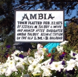
Ambia was laid out by Ezekiel M. Talbot and his wife Marietta on February 22, 1875, and named for their daughter Ambia Talbot. (The couple had two years earlier planned the nearby town of TalbotTalbot, Indiana
Talbot is an unincorporated town in Hickory Grove Township, Benton County, Indiana. It is part of the Lafayette, Indiana Metropolitan Statistical Area.-History:...
.) Its first building was a house erected by James C. Pugh which was soon joined by a grain elevator, general store and blacksmith. A drug store, hardware store, hotel, physician and a variety of other establishments followed.
Ambia was a stop on the Lafayette, Muncie and Bloomington Railroad
Lafayette, Muncie and Bloomington Railroad
The LaFayette, Muncie and Bloomington Railroad was a railroad company incorporated in Indiana on July 13, 1869. It operated in Indiana and eastern Illinois until its sale on April 28, 1879, to the Lake Erie and Western Railroad. The LM&B line was so named because it ran from the city of Muncie...
(later the Lake Erie and Western
Lake Erie and Western Railroad
The Lake Erie and Western Railroad was a railroad that operated in Ohio, Indiana and Illinois.-The beginning:The Seney Syndicate linked several short railroads in Ohio, Indiana, and Illinois to form the Lake Erie and Western Railroad in 1879 and 1880...
) line which ran between Lafayette
Lafayette, Indiana
Lafayette is a city in and the county seat of Tippecanoe County, Indiana, United States, northwest of Indianapolis. As of the 2010 census, the city had a total population of 67,140. West Lafayette, on the other side of the Wabash River, is home to Purdue University, which has a large impact on...
and Hoopeston
Hoopeston, Illinois
Hoopeston is a city in Grant Township, Vermilion County, Illinois, United States. It is part of the Danville, Illinois, Metropolitan Statistical Area. The population was 5,965 at the 2000 census, and 5,602 in 2009.-History:Hoopeston was laid out in 1871...
. The Wabash Railway Company, which built a stretch of the LM&B through Illinois, originally wanted to construct a railway switch at a site known as Weaver City, a small town just west of Ambia in Vermilion County, Illinois
Vermilion County, Illinois
Vermilion County is a county located in the eastern part of the U.S. state of Illinois, between the Indiana border and Champaign County. It was established in 1826 and was the 45th of Illinois' 102 counties...
; the owner of the property, however, refused to grant land for it. In response, the railway officials sent a force of men without notice to move the station house from Weaver City half a mile east across the state border, which they did on the Sunday morning of March 10, 1873. The town's businesses and residents followed and Weaver City faded from existence while Ambia sprang up near the station's new site.
Geography
Ambia is located at 40°29′24"N 87°30′58"W (40.489878, -87.516200) in the extreme southwest corner of the county, in Hickory Grove Township. The Kankakee, Beaverville and Southern RailroadKankakee, Beaverville and Southern Railroad
The Kankakee, Beaverville and Southern Railroad Company is a Class III railroad serving agricultural communities in east-central Illinois and west-central Indiana.-History:...
and Indiana State Road 352
Indiana State Road 352
State Road 352 in the U.S. state of Indiana is an east–west state highway in Benton County in the west-central part of the state.-Route description:...
pass through the town, and the upper end of the North Fork of the Vermilion River
Vermilion River (Wabash River tributary)
The Vermilion River is a tributary of the Wabash River in the states of Illinois and Indiana, United States.There are two "Vermilion Rivers" in Illinois. The Wabash tributary flows south, while the other Vermilion River flows north to the Illinois River...
flows nearby.
According to the United States Census Bureau
United States Census Bureau
The United States Census Bureau is the government agency that is responsible for the United States Census. It also gathers other national demographic and economic data...
, the town has a total area of 0.2 square mile (0.517997622 km²), all of it land.
Demographics
Census
A census is the procedure of systematically acquiring and recording information about the members of a given population. It is a regularly occurring and official count of a particular population. The term is used mostly in connection with national population and housing censuses; other common...
of 2000, there were 197 people, 71 households, and 50 families residing in the town. The population density
Population density
Population density is a measurement of population per unit area or unit volume. It is frequently applied to living organisms, and particularly to humans...
was 1,350.9 people per square mile (507.1/km²). There were 85 housing units at an average density of 582.9 per square mile (218.8/km²). The racial makeup of the town was 87.31% White, 9.64% from other races
Race (United States Census)
Race and ethnicity in the United States Census, as defined by the Federal Office of Management and Budget and the United States Census Bureau, are self-identification data items in which residents choose the race or races with which they most closely identify, and indicate whether or not they are...
, and 3.05% from two or more races. Hispanic or Latino of any race were 17.77% of the population.
There were 71 households out of which 35.2% had children under the age of 18 living with them, 62.0% were married couples
Marriage
Marriage is a social union or legal contract between people that creates kinship. It is an institution in which interpersonal relationships, usually intimate and sexual, are acknowledged in a variety of ways, depending on the culture or subculture in which it is found...
living together, 8.5% had a female householder with no husband present, and 28.2% were non-families. 26.8% of all households were made up of individuals and 16.9% had someone living alone who was 65 years of age or older. The average household size was 2.77 and the average family size was 3.45.
In the town the population was spread out with 29.9% under the age of 18, 7.6% from 18 to 24, 27.4% from 25 to 44, 19.8% from 45 to 64, and 15.2% who were 65 years of age or older. The median age was 34 years. For every 100 females there were 107.4 males. For every 100 females age 18 and over, there were 94.4 males.
The median income for a household in the town was $36,667, and the median income for a family was $38,750. Males had a median income of $30,417 versus $21,000 for females. The per capita income
Per capita income
Per capita income or income per person is a measure of mean income within an economic aggregate, such as a country or city. It is calculated by taking a measure of all sources of income in the aggregate and dividing it by the total population...
for the town was $14,169. None of the families and 0.5% of the population were living below the poverty line, including no under eighteens and 4.8% of those over 64.