
St. Matthews, Kentucky
Encyclopedia
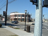
St. Matthews is the 20th largest city in Kentucky
, United States
and is a prominent suburb of Louisville
. It is located 8 miles east of downtown Louisville
in Jefferson County
. It is one of the state's major shopping areas, being home to second and fifth largest malls in Kentucky (Mall St. Matthews
and Oxmoor Center
), respectively, along with many smaller shopping centers along Shelbyville Road.
In 2003 St. Matthews became part of the new "Louisville Metro" government. It remains an independent city with its own mayor and emergency services. It is not counted in Louisville's population, although its citizens can vote for Louisville Mayor and Metro Council members.
of varying cultures lived along the waterways of Kentucky for thousands of years before European contact. The Mississippian culture
was a complex, sophisticated prehistoric culture whose people built massive earthwork mounds
in the Ohio River valley, areas they settled between 1000 CE and 1400 CE. They preceded the historic tribes of the Ohio River area.
The area eventually known as St. Matthews was first settled by European Americans in 1779 by Colonial James John Floyd
. Floyd, who had conducted an important survey of Jefferson County in 1774, bought 2000 acres (8 km²) of land from soldiers who had been awarded the parcels for their service in the French and Indian War
. He arrived overland on November 8, 1779, bringing several family members and a black slave. They built cabins and a stockade
, which came to be known as Floyd's Station
, as early forts were called.
During the early 19th century, "the area was developed into several plantation
tracts. The area was known as 'the garden of the state' for the produce that it grew and for which it served as a distribution point." As with most areas of the Inner Bluegrass Region
, labor on the plantations was mostly enslaved
African Americans. Major crops were tobacco
and hemp
, and the breeding of quality livestock, including horses, was important to the economy. With changes in agriculture, in the years before the Civil War, Kentucky planters were selling excess slaves at markets in Louisville for shipment to the Deep South, where new plantations for sugar and cotton had created huge demand for slave labor.
St. Matthews developed at the same time as nearby Louisville
. It was centered around the intersection of present-day Breckenridge Lane, Shelbyville Road, and Westport Road. By 1840, the community was known as Gilman's Point, after local tavern owner Daniel Gilman. The name St. Matthews emerged in 1850, after the area's first church, St. Matthews Episcopal Church
. It became official in 1851 when a newly opened post office adopted the name. Numerous other Protestant churches were founded. The oldest of three Catholic
churches in the city is Holy Trinity, built in 1882. Trinity High School
was established nearby in association with the church.
The community was connected to major southern cities by the Louisville, Lexington & Cincinnati Railroad
, built in the mid-19th century, and a later railroad connecting Louisville to Anchorage
and Middletown
. The economy of St. Matthews was heavily agricultural well into the 20th century. From 1910 to 1946, it was home to the St. Matthews Produce Exchange, which was once the second-largest potato shipper in the country.
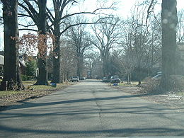
During the first half of the 20th century, the farms were gradually subdivided. With residential development, St. Matthews took on a suburban character. The original landowners names, such as Brown, Rudy, Nanz, Monohan and Oeschner, have been given to many of the local streets. The town's first bank was founded in 1905. A modern shopping district began developing in the 1920s that would include the landmark Vogue Theater, opened in 1938.
 Growth of the area was accelerated by the Ohio River flood of 1937
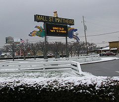
, which caused many families to leave low-lying ground in Louisville and move to the higher ground of St. Matthews. It incorporated as a city in 1950, partially to address infrastructure problems and build a sewer system. The Mall St. Matthews
, Louisville's first indoor shopping mall, opened around this time.
In 2001 the cities of Broad Fields
, Cherrywood Village
, Fairmeade
, Plymouth Village
and Springlee
were annexed by the City of Saint Matthews.
The boundaries of St. Matthews are roughly Cannons Lane to the west, I-264
to the south and east, and several subdivisions off of Brownsboro Road to the north. These include Bellewood
, Brownsboro Village
, Maryhill Estates
and Windy Hills
. The cities of Richlawn
and Norbourne Estates
are enclaves within St. Matthews.
According to the United States Census Bureau
, the city has a total area of 4 square miles (10.4 km²), all of it land.
 As of the census
of 2000, there were 15,852 people, 7,978 households, and 3,661 families residing in the city. The population density
was 3,938.3 people per square mile (1,518.7/km²). There were 8,537 housing units at an average density of 2,121.0 per square mile (817.9/km²). The racial makeup of the city was 90.32% White, 4.95% African American, 0.15% Native American, 2.62% Asian, 0.01% Pacific Islander, 0.59% from other races
, and 1.36% from two or more races. Hispanic or Latino of any race were 1.69% of the population.
There were 7,978 households out of which 19.0% had children under the age of 18 living with them, 34.9% were married couples
living together, 8.4% had a female householder with no husband present, and 54.1% were non-families. 45.2% of all households were made up of individuals and 14.1% had someone living alone who was 65 years of age or older. The average household size was 1.94 and the average family size was 2.76.
In the city the population was spread out with 17.0% under the age of 18, 10.2% from 18 to 24, 35.6% from 25 to 44, 20.1% from 45 to 64, and 17.1% who were 65 years of age or older. The median age was 37 years. For every 100 females there were 86.6 males. For every 100 females age 18 and over, there were 83.6 males.
The median income for a household in the city was $42,219, and the median income for a family was $56,473. Males had a median income of $37,306 versus $31,163 for females. The per capita income
for the city was $28,601. About 4.9% of families and 6.7% of the population were below the poverty line, including 7.8% of those under age 18 and 5.4% of those age 65 or over.
Kentucky
The Commonwealth of Kentucky is a state located in the East Central United States of America. As classified by the United States Census Bureau, Kentucky is a Southern state, more specifically in the East South Central region. Kentucky is one of four U.S. states constituted as a commonwealth...
, United States
United States
The United States of America is a federal constitutional republic comprising fifty states and a federal district...
and is a prominent suburb of Louisville
Louisville, Kentucky
Louisville is the largest city in the U.S. state of Kentucky, and the county seat of Jefferson County. Since 2003, the city's borders have been coterminous with those of the county because of a city-county merger. The city's population at the 2010 census was 741,096...
. It is located 8 miles east of downtown Louisville
Downtown Louisville
Downtown Louisville is the largest central business district in the Commonwealth of Kentucky and the urban hub of the Louisville, Kentucky Metropolitan Area. Its boundaries are the Ohio River to the north, Hancock Street to the east, York and Jacob Streets to the south, and 9th Street to the west...
in Jefferson County
Jefferson County, Kentucky
As of the census of 2000, there were 693,604 people, 287,012 households, and 183,113 families residing in the county. The population density was . There were 305,835 housing units at an average density of...
. It is one of the state's major shopping areas, being home to second and fifth largest malls in Kentucky (Mall St. Matthews
Mall St. Matthews
Mall St. Matthews is a Louisville, Kentucky shopping mall located at 5000 Shelbyville Road in the eastern suburb of St. Matthews.Opened in 1962 and originally named The Mall, it was the first enclosed suburban shopping mall in the state of Kentucky. Located next to the Watterson Expressway, the...
and Oxmoor Center
Oxmoor Center
Oxmoor Center is a Louisville, Kentucky shopping mall located at 7900 Shelbyville Road in eastern Louisville.Opened in 1971 on the opposing side of the Watterson Expressway from Mall St. Matthews, the mall originally had Shillito's and Stewart Dry Goods as its anchor stores...
), respectively, along with many smaller shopping centers along Shelbyville Road.
In 2003 St. Matthews became part of the new "Louisville Metro" government. It remains an independent city with its own mayor and emergency services. It is not counted in Louisville's population, although its citizens can vote for Louisville Mayor and Metro Council members.
History
Indigenous peoplesIndigenous peoples
Indigenous peoples are ethnic groups that are defined as indigenous according to one of the various definitions of the term, there is no universally accepted definition but most of which carry connotations of being the "original inhabitants" of a territory....
of varying cultures lived along the waterways of Kentucky for thousands of years before European contact. The Mississippian culture
Mississippian culture
The Mississippian culture was a mound-building Native American culture that flourished in what is now the Midwestern, Eastern, and Southeastern United States from approximately 800 CE to 1500 CE, varying regionally....
was a complex, sophisticated prehistoric culture whose people built massive earthwork mounds
Earthworks (archaeology)
In archaeology, earthwork is a general term to describe artificial changes in land level. Earthworks are often known colloquially as 'lumps and bumps'. Earthworks can themselves be archaeological features or they can show features beneath the surface...
in the Ohio River valley, areas they settled between 1000 CE and 1400 CE. They preceded the historic tribes of the Ohio River area.
The area eventually known as St. Matthews was first settled by European Americans in 1779 by Colonial James John Floyd
James John Floyd
James John Floyd , better known as John Floyd, was a pioneer of the Midwestern United States around the Louisville, Kentucky area where he worked as a surveyor for land development and as a military figure. Floyd was an early settler of St. Matthews, Kentucky and helped lay out Louisville...
. Floyd, who had conducted an important survey of Jefferson County in 1774, bought 2000 acres (8 km²) of land from soldiers who had been awarded the parcels for their service in the French and Indian War
French and Indian War
The French and Indian War is the common American name for the war between Great Britain and France in North America from 1754 to 1763. In 1756, the war erupted into the world-wide conflict known as the Seven Years' War and thus came to be regarded as the North American theater of that war...
. He arrived overland on November 8, 1779, bringing several family members and a black slave. They built cabins and a stockade
Stockade
A stockade is an enclosure of palisades and tall walls made of logs placed side by side vertically with the tops sharpened to provide security.-Stockade as a security fence:...
, which came to be known as Floyd's Station
Floyd's Station (Kentucky)
Floyd's Station was a fort on Beargrass Creek in what is now St. Matthews, Kentucky. In November of 1779 James John Floyd built cabins and a stockade near what is now Breckenridge Lane. In 1783, John Floyd, future Governor of Virginia was born in the Station. The pioneer father was killed by...
, as early forts were called.
During the early 19th century, "the area was developed into several plantation
Plantation
A plantation is a long artificially established forest, farm or estate, where crops are grown for sale, often in distant markets rather than for local on-site consumption...
tracts. The area was known as 'the garden of the state' for the produce that it grew and for which it served as a distribution point." As with most areas of the Inner Bluegrass Region
Bluegrass region
The Bluegrass Region is a geographic region in the state of Kentucky, United States. It occupies the northern part of the state and since European settlement has contained a majority of the state's population and its largest cities....
, labor on the plantations was mostly enslaved
Slavery
Slavery is a system under which people are treated as property to be bought and sold, and are forced to work. Slaves can be held against their will from the time of their capture, purchase or birth, and deprived of the right to leave, to refuse to work, or to demand compensation...
African Americans. Major crops were tobacco
Tobacco
Tobacco is an agricultural product processed from the leaves of plants in the genus Nicotiana. It can be consumed, used as a pesticide and, in the form of nicotine tartrate, used in some medicines...
and hemp
Hemp
Hemp is mostly used as a name for low tetrahydrocannabinol strains of the plant Cannabis sativa, of fiber and/or oilseed varieties. In modern times, hemp has been used for industrial purposes including paper, textiles, biodegradable plastics, construction, health food and fuel with modest...
, and the breeding of quality livestock, including horses, was important to the economy. With changes in agriculture, in the years before the Civil War, Kentucky planters were selling excess slaves at markets in Louisville for shipment to the Deep South, where new plantations for sugar and cotton had created huge demand for slave labor.
St. Matthews developed at the same time as nearby Louisville
Louisville, Kentucky
Louisville is the largest city in the U.S. state of Kentucky, and the county seat of Jefferson County. Since 2003, the city's borders have been coterminous with those of the county because of a city-county merger. The city's population at the 2010 census was 741,096...
. It was centered around the intersection of present-day Breckenridge Lane, Shelbyville Road, and Westport Road. By 1840, the community was known as Gilman's Point, after local tavern owner Daniel Gilman. The name St. Matthews emerged in 1850, after the area's first church, St. Matthews Episcopal Church
Episcopal Church (United States)
The Episcopal Church is a mainline Anglican Christian church found mainly in the United States , but also in Honduras, Taiwan, Colombia, Ecuador, Haiti, the Dominican Republic, Venezuela, the British Virgin Islands and parts of Europe...
. It became official in 1851 when a newly opened post office adopted the name. Numerous other Protestant churches were founded. The oldest of three Catholic
Catholic
The word catholic comes from the Greek phrase , meaning "on the whole," "according to the whole" or "in general", and is a combination of the Greek words meaning "about" and meaning "whole"...
churches in the city is Holy Trinity, built in 1882. Trinity High School
Trinity High School (Louisville, Kentucky)
Trinity High School is a Catholic, all-boys, college preparatory high school located in St. Matthews, Kentucky, a city within the Louisville Metro governmental area. Trinity first opened its doors in 1953, when Archbishop John Floersh anticipated the growth of Louisville's eastern suburbs by...
was established nearby in association with the church.
The community was connected to major southern cities by the Louisville, Lexington & Cincinnati Railroad
Louisville and Nashville Railroad
The Louisville and Nashville Railroad was a Class I railroad that operated freight and passenger services in the southeast United States.Chartered by the state of Kentucky in 1850, the L&N, as it was generally known, grew into one of the great success stories of American business...
, built in the mid-19th century, and a later railroad connecting Louisville to Anchorage
Anchorage, Kentucky
As of the census of 2000, there were 2,264 people, 729 households, and 643 families residing in the city. The population density was 744.0 people per square mile . There were 750 housing units at an average density of 246.5 per square mile...
and Middletown
Middletown, Kentucky
The median income for a household in the city was $53,608, and the median income for a family was $61,667. Males had a median income of $45,417 versus $33,135 for females. The per capita income for the city was $26,660...
. The economy of St. Matthews was heavily agricultural well into the 20th century. From 1910 to 1946, it was home to the St. Matthews Produce Exchange, which was once the second-largest potato shipper in the country.
During the first half of the 20th century, the farms were gradually subdivided. With residential development, St. Matthews took on a suburban character. The original landowners names, such as Brown, Rudy, Nanz, Monohan and Oeschner, have been given to many of the local streets. The town's first bank was founded in 1905. A modern shopping district began developing in the 1920s that would include the landmark Vogue Theater, opened in 1938.
Ohio River flood of 1937
The Ohio River flood of 1937 took place in late January and February 1937. With damage stretching from Pittsburgh to Cairo, Illinois, one million persons were left homeless, with 385 dead and property losses reaching $500 million...
, which caused many families to leave low-lying ground in Louisville and move to the higher ground of St. Matthews. It incorporated as a city in 1950, partially to address infrastructure problems and build a sewer system. The Mall St. Matthews
Mall St. Matthews
Mall St. Matthews is a Louisville, Kentucky shopping mall located at 5000 Shelbyville Road in the eastern suburb of St. Matthews.Opened in 1962 and originally named The Mall, it was the first enclosed suburban shopping mall in the state of Kentucky. Located next to the Watterson Expressway, the...
, Louisville's first indoor shopping mall, opened around this time.
In 2001 the cities of Broad Fields
Broad Fields, Kentucky
Broad Fields is a neighborhood of St. Matthews, Kentucky. Broad Fields was a Sixth Class city in Jefferson County, Kentucky, United States. Broad Fields was incorporated on May 24, 1957. Broad Fields was dissolved on July 1, 2000 and annexed by St. Matthews on January 8, 2001...
, Cherrywood Village
Cherrywood Village, Kentucky
Cherrywood Village was a city in Jefferson County, Kentucky, United States. Cherrywood Village was annexed by the City of Saint Matthews. The population was 327 at the 2000 census.-Geography:Cherrywood Village is located at ....
, Fairmeade
Fairmeade, Kentucky
Fairmeade is a neighborhood of St. Matthews, Kentucky. The population was 264 at the 2000 census.-History:Until 2000 Fairmeade was an independent Sixth class city in Jefferson County, Kentucky, United States. Fairmeade was incorporated on October 8, 1953 and dissolved on September 1, 2000....
, Plymouth Village
Plymouth Village, Kentucky
Plymouth Village is a neighborhood of St. Matthews, Kentucky a city in Jefferson County, Kentucky, United States. The population was 201 at the 2000 census.-History:Plymouth Village was incorporated as a city on September 17, 1956...
and Springlee
Springlee, Kentucky
Springlee is a neighborhood of St. Matthews, Kentucky. The population was 426 at the 2000 census. Until 2000 Springlee was an independent Sixth Class city in Jefferson County, Kentucky, United States. Springlee was incorporated on April 25, 1950. Springlee was dissolved on December 5, 2000 and...
were annexed by the City of Saint Matthews.
The boundaries of St. Matthews are roughly Cannons Lane to the west, I-264
Interstate 264 (Kentucky)
The Henry Watterson Expressway, also known as the Georgia Davis Powers/Shawnee Expressway west of US 31W, is one of two Interstate Highways in the United States designated as Interstate 264 . It is 22.93 miles in length, and runs an open circle around central Louisville, Kentucky...
to the south and east, and several subdivisions off of Brownsboro Road to the north. These include Bellewood
Bellewood, Kentucky
Bellewood is a city in Jefferson County, Kentucky, United States. The population was 300 at the 2000 census.-Geography:Bellewood is located at ....
, Brownsboro Village
Brownsboro Village, Kentucky
Brownsboro Village is a city in Jefferson County, Kentucky, United States. The population was 318 at the 2000 census.-Geography:Brownsboro Village is located at ....
, Maryhill Estates
Maryhill Estates, Kentucky
Maryhill Estates is a city in Jefferson County, Kentucky, United States. The population was 175 at the 2000 census.Maryhill Estates incorporated in 1963 and was developed in the early 1960s. Developer John A...
and Windy Hills
Windy Hills, Kentucky
Windy Hills is a city in eastern Jefferson County, Kentucky, United States. The population was 2,480 at the 2000 census.-Geography:Windy Hills is located at ....
. The cities of Richlawn
Richlawn, Kentucky
Richlawn is a city in eastern Jefferson County, Kentucky, United States. The population was 454 at the 2000 census. It is surrounded by the larger city of St...
and Norbourne Estates
Norbourne Estates, Kentucky
Norbourne Estates is a city in Jefferson County, Kentucky, United States. The population was 461 at the 2000 census.-Geography:Norbourne Estates is located at ....
are enclaves within St. Matthews.
Geography
St. Matthews is located at 38°15′0"N 85°38′33"W (38.249931, -85.642613).According to the United States Census Bureau
United States Census Bureau
The United States Census Bureau is the government agency that is responsible for the United States Census. It also gathers other national demographic and economic data...
, the city has a total area of 4 square miles (10.4 km²), all of it land.
Demographics
Census
A census is the procedure of systematically acquiring and recording information about the members of a given population. It is a regularly occurring and official count of a particular population. The term is used mostly in connection with national population and housing censuses; other common...
of 2000, there were 15,852 people, 7,978 households, and 3,661 families residing in the city. The population density
Population density
Population density is a measurement of population per unit area or unit volume. It is frequently applied to living organisms, and particularly to humans...
was 3,938.3 people per square mile (1,518.7/km²). There were 8,537 housing units at an average density of 2,121.0 per square mile (817.9/km²). The racial makeup of the city was 90.32% White, 4.95% African American, 0.15% Native American, 2.62% Asian, 0.01% Pacific Islander, 0.59% from other races
Race (United States Census)
Race and ethnicity in the United States Census, as defined by the Federal Office of Management and Budget and the United States Census Bureau, are self-identification data items in which residents choose the race or races with which they most closely identify, and indicate whether or not they are...
, and 1.36% from two or more races. Hispanic or Latino of any race were 1.69% of the population.
There were 7,978 households out of which 19.0% had children under the age of 18 living with them, 34.9% were married couples
Marriage
Marriage is a social union or legal contract between people that creates kinship. It is an institution in which interpersonal relationships, usually intimate and sexual, are acknowledged in a variety of ways, depending on the culture or subculture in which it is found...
living together, 8.4% had a female householder with no husband present, and 54.1% were non-families. 45.2% of all households were made up of individuals and 14.1% had someone living alone who was 65 years of age or older. The average household size was 1.94 and the average family size was 2.76.
In the city the population was spread out with 17.0% under the age of 18, 10.2% from 18 to 24, 35.6% from 25 to 44, 20.1% from 45 to 64, and 17.1% who were 65 years of age or older. The median age was 37 years. For every 100 females there were 86.6 males. For every 100 females age 18 and over, there were 83.6 males.
The median income for a household in the city was $42,219, and the median income for a family was $56,473. Males had a median income of $37,306 versus $31,163 for females. The per capita income
Per capita income
Per capita income or income per person is a measure of mean income within an economic aggregate, such as a country or city. It is calculated by taking a measure of all sources of income in the aggregate and dividing it by the total population...
for the city was $28,601. About 4.9% of families and 6.7% of the population were below the poverty line, including 7.8% of those under age 18 and 5.4% of those age 65 or over.
External links
- City of St. Matthews Official site
- http://digital.library.louisville.edu/cdm4/results.php?CISORESTMP=results.php&CISOVIEWTMP=item_viewer.php&CISOMODE=grid&CISOGRID=thumbnail,A,1;title,A,1;descri,200,0;none,200,0;none,A,0;20;title,none,none,none,none&CISOBIB=title,A,1,N;subjec,A,0,N;descri,200,0,N;none,A,0,N;none,A,0,N;20;title,none,none,none,none&CISOTHUMB=20%20(4x5);title,none,none,none,none&CISOTITLE=20;title,none,none,none,none&CISOHIERA=20;subjec,title,none,none,none&CISOSUPPRESS=0&CISOTYPE=link&CISOOP1=exact&CISOFIELD1=title&CISOBOX1=&CISOOP2=exact&CISOFIELD2=coveraa&CISOBOX2=Saint+Matthews+%28Ky.%29&CISOOP3=exact&CISOFIELD3=descri&CISOBOX3=&CISOOP4=exact&CISOFIELD4=CISOSEARCHALL&CISOBOX4=&c=exact&CISOROOT=all Images of Saint Matthews (Ky.) in the University of Louisville Libraries Digital Collections]