
Frisia
Encyclopedia
Frisia is a coastal region along the southeastern corner of the North Sea
, i.e. the German Bight
. Frisia is the traditional homeland
of the Frisians
, a Germanic people who speak Frisian, a language group closely related to the English language
. Frisia extends from the northwestern Netherlands
across northwestern Germany
to the border of Denmark
(Vidå
).
The three groups of the Frisian Islands
(the West
, East
and North Frisian Islands
) stretch more or less correspondingly along these three sections of the German Bight
coast.
West Frisia corresponds roughly to the Dutch province
of Friesland
(Fryslân), the northern part of North Holland
province (the historical region of West Friesland
, the westernmost portion of the traditional region of West Frisia), and also modern Groningen
province, though the Western Frisian language is only spoken in Friesland proper. Dialect
s with strong Frisian substrate
s, including Low German
and Low Franconian
, are also spoken in West Frisia. In the northern province of Groningen, people speak Gronings
, a Low Saxon
dialect with a strong Frisian substrate.
East Frisia includes areas located in the northwest of the German state of Lower Saxony
, including the districts of Aurich
, Leer
, Wittmund
and Friesland
, as well as the urban districts of Emden
and Wilhelmshaven
, the Saterland
, the Land Wursten
and former Rüstringen (Butjadingen
). East Frisia
is also the name of a historical county in that area. The German name "Ostfriesland" distinguishes the former county from "Ost-Friesland", which means the whole eastern Frisian area.
The portions of North Frisia within the German state of Schleswig-Holstein
are part of the district of Nordfriesland
and stretch along the coast, including the coastal islands from the Eider River
to the border of Denmark in the north. The North Sea
island of Heligoland
, while not part of Nordfriesland district, is also part of traditional North Frisia.
A half-million Frisians in the province of Friesland in the Netherlands speak West Frisian
. Several thousand people in Nordfriesland and Heligoland in Germany speak a collection of North Frisian
dialects that are often unintelligible to each other. A small number Saterland Frisian language
speakers live in four villages in Lower Saxony
, in the Saterland
region of Cloppenburg
county, just beyond the boundaries of traditional East Frisia
. Many Frisians speak Low Saxon dialects, especially in East Frisia, but also in West and North Frisia.
which is a hypothetical historic region linked by language and culture.
began settling in Frisia around 500 BC. According to Pliny the Elder
, in Roman times, the Frisians (or their close neighbours, the Chauci
) lived on terps
, man-made hills.
According to other sources, the Frisians lived along a broader expanse of the North Sea (or "Frisian Sea") coast.
Frisia at this time comprised the present provinces of Friesland
and North Holland
.
 In the 7th and 8th centuries, the Frankish
chronologies mention the northern Low Countries
as the kingdom of the Frisians. However, these were probably not the Frisians of Roman times. This kingdom comprised the coastal seelande provinces of the Netherlands
, from the Scheldt to the Weser and the German
North Sea
coast eastwards beyond. During this time, the Frisian language was spoken along the entire southern North Sea coast and, today, this region is sometimes referred to as Greater Frisia or Frisia Magna.
Distant authors seem to have made little distinction between Frisian and Saxon. The Byzantine Procopius
described three peoples living in Britain: Angles, Frisians and Britons, and the Danish author of Knútsdrápa
celebrating the 11th-century Canute the Great
used 'Frisians' as a synonym of 'English'. To account for East Anglia
's distinct land-holdings in carucate
s forming vill
s assembled in leet
s, partible inheritance patterns of lands held in common among a kinship, resistance to manorialization
and other social institutions, a case has been made for Frisian cultural domination there from the fifth century. East Anglian sources called the inhabitants of 'Frisia' Warnii instead of Frisians.
The earliest Frisian records name four social classes, the ethelings (nobiles
in Latin documents) and frilings, who together made up the "Free Frisians" who might bring suit at court, and the laten or liten with the slaves, who were absorbed into the laten during the Early Middle Ages
, as slavery was not so much formally abolished, as evaporated. The laten were tenants of lands they did not own and might be tied to it in the manner of serf
s, but in later times might buy their freedom.
The basic land-holding unit, for assessment of taxes and military contributions, was the ploegg (cf. "plow") or teen (cf. "hundred"), though it passed under other local names. The teen was pledged to supply ten men for the heer, the army. Ploegg or teen formed a unit who were collectively responsible for the performance of any of the men. The ploegg or East Frisian rott was a compact holding that originated with a single lineage or kinship, whose men in early times went to war under their chief, and devolved in medieval times into a union of neighbors rather than kith and kin. Several, often three, ploeggs were grouped into a burar, whose members controlled and adjudicated the uses of pasurage (but not tillage) which the ploeggs held in common, and came to be in charge of roads, ditches and dikes. Twelve ploeggs made up a "long" hundred, responsible for supplying a hundred armed men, four of which made a go (cf. Gau).
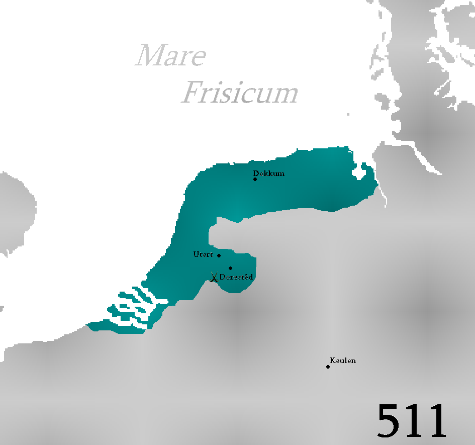
The 7th-century Frisian realm (650-734) under the kings Aldegisel and Redbad, had its centre of power in the city of Utrecht
. Its ancient customary law was drawn up as the Lex Frisionum
in the eighth century. Its end came in 734 at the Battle of the Boarn
, when the Frisians were defeated by the Franks
, who then conquered the western part up to the Lauwers
. They conquered the area east of the Lauwers in 785, when Charlemagne
defeated Widukind
. The Carolingians laid Frisia under the rule of grewan, a title that has been loosely related to count
in its early sense of "governor" rather than "feudal overlord
".
This Frisia Magna was partly occupied by Vikings in the 840s, until they were expelled between 885 and 920. It has also been suggested that the Vikings did not conquer Frisia, but settled in certain parts (such as the island of Wieringen), where they built simple forts and cooperated and traded with the native Frisians. One of their leaders was Rorik of Dorestad.
s in West Friesland
, which became more and more separated from Friesland
due to floods. After a few centuries of increasingly divergent history, the western part of Frisia became the county of Holland
in 1101, Frisia began to identify itself as a country with free folk in the Middle Ages
. Frisia no longer belonged to the bishopric of Utrecht. There were many floods in the 11th and 12th centuries, which led to the deaths of many and eventually formed the Zuider Zee
. The largest flood occurred in 1322.
, Groningen
, East Frisia
and the German
North Sea coast, and parts of the Danish
North Sea
coast (Schleswig
). But the Opstalboom league did not consist only of Frisians, as the area of Zevenwouden and the city of Groningen were Saxon. Some Frisians lived under the rule of the counts of Holland in West Friesland
. The Opstalboom League was short-lived; it collapsed after a few years because of continual internal strife.
 The 15th century saw the end of the free Frisians. The city of Groningen started to dominate Groningen
. A petty nobleman in East Frisia
managed to defeat the other petty noblemen and became count of East Frisia. The Archbishop of Bremen-Hamburg and the king of Denmark conquered large areas of Frisia. Only Friesland
remained for the Frisian Freedom. Friesland was conquered in the 1490s by Duke Albert of Saxony-Meissen.
Later, the giant Pier Gerlofs Donia
(Grutte Pier) would fight for his country's freedom. He had many successes, but ultimately failed to secure Frisia's independence. He died as a farmer in 1520. A statue dedicated to him is displayed to the right. He is estimated to have been seven feet tall.

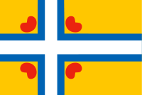 Although the Frisian regions have their own separate flags, Frisia has not historically had a flag of its own. The flag for united Frisia, known as the Inter-Frisian Flag (Ynterfryske Flagge), was launched in September 2006 by the Groep fan Auwerk
, which supports a united Frisia as a recognised country.
The flag is inspired by the Nordic Cross Flag
. The four pompeblêden (water lily leaves) are derived from the seven pompeblêden on the (West) Friesland
flag, but the number represents the three separate Frisian regions plus Groningen (Eastlauwersk Fryslân). The flag was not accepted by the Inter-Frisian Council.
, De Bosatlas van Fryslân was published by the Dutch publisher Noordhoff in Groningen, almost 500 pages and 4 kg. This Bosatlas van Fryslân is completely dedicated to the Dutch province of Friesland, with historical and modern maps, aerophotography and background information on hundreds of topics. It also contains a complete set of topographical maps, in the most detailed scale
(1:25 000).
North Sea
In the southwest, beyond the Straits of Dover, the North Sea becomes the English Channel connecting to the Atlantic Ocean. In the east, it connects to the Baltic Sea via the Skagerrak and Kattegat, narrow straits that separate Denmark from Norway and Sweden respectively...
, i.e. the German Bight
German Bight
German Bight is the southeastern bight of the North Sea bounded by the Netherlands and Germany to the south, and Denmark and Germany to the east . To the north and west it is limited by the Dogger Bank. The Bight contains the Frisian and Danish Islands. The Wadden Sea is approximately ten to...
. Frisia is the traditional homeland
Homeland
A homeland is the concept of the place to which an ethnic group holds a long history and a deep cultural association with —the country in which a particular national identity began. As a common noun, it simply connotes the country of one's origin...
of the Frisians
Frisians
The Frisians are a Germanic ethnic group native to the coastal parts of the Netherlands and Germany. They are concentrated in the Dutch provinces of Friesland and Groningen and, in Germany, East Frisia and North Frisia, that was a part of Denmark until 1864. They inhabit an area known as Frisia...
, a Germanic people who speak Frisian, a language group closely related to the English language
English language
English is a West Germanic language that arose in the Anglo-Saxon kingdoms of England and spread into what was to become south-east Scotland under the influence of the Anglian medieval kingdom of Northumbria...
. Frisia extends from the northwestern Netherlands
Netherlands
The Netherlands is a constituent country of the Kingdom of the Netherlands, located mainly in North-West Europe and with several islands in the Caribbean. Mainland Netherlands borders the North Sea to the north and west, Belgium to the south, and Germany to the east, and shares maritime borders...
across northwestern Germany
Germany
Germany , officially the Federal Republic of Germany , is a federal parliamentary republic in Europe. The country consists of 16 states while the capital and largest city is Berlin. Germany covers an area of 357,021 km2 and has a largely temperate seasonal climate...
to the border of Denmark
Denmark
Denmark is a Scandinavian country in Northern Europe. The countries of Denmark and Greenland, as well as the Faroe Islands, constitute the Kingdom of Denmark . It is the southernmost of the Nordic countries, southwest of Sweden and south of Norway, and bordered to the south by Germany. Denmark...
(Vidå
Vidå
The Vidå is a creek in Jutland, Denmark. The creek starts east of Tønder and flows to the west, ending in the North Sea. The Vidå is in parts border between Denmark and Germany .South of the river live the North Frisians....
).
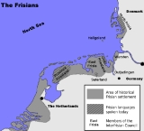
Divisions
Frisia is commonly divided into three sections:- Province of FrieslandFrieslandFriesland is a province in the north of the Netherlands and part of the ancient region of Frisia.Until the end of 1996, the province bore Friesland as its official name. In 1997 this Dutch name lost its official status to the Frisian Fryslân...
in the Netherlands (West Frisia) - East FrisiaEast FrisiaEast Frisia or Eastern Friesland is a coastal region in the northwest of the German federal state of Lower Saxony....
in Lower SaxonyLower SaxonyLower Saxony is a German state situated in north-western Germany and is second in area and fourth in population among the sixteen states of Germany... - North FrisiaNorth FrisiaNorth Frisia or Northern Friesland is the northernmost portion of Frisia, located primarily in Germany between the rivers Eider and Wiedau/Vidå. It includes a number of islands, e.g., Sylt, Föhr, Amrum, Nordstrand, and Heligoland.-History:...
in Schleswig-HolsteinSchleswig-HolsteinSchleswig-Holstein is the northernmost of the sixteen states of Germany, comprising most of the historical duchy of Holstein and the southern part of the former Duchy of Schleswig...
The three groups of the Frisian Islands
Frisian Islands
The Frisian Islands, also known as the Wadden Islands or Wadden Sea Islands, form an archipelago at the eastern edge of the North Sea in northwestern Europe, stretching from the north-west of the Netherlands through Germany to the west of Denmark...
(the West
West Frisian Islands
The West Frisian Islands are a chain of islands in the North Sea off the Dutch coast, along the edge of the Wadden Sea. They continue further east as the German East Frisian Islands and are part of the Frisian Islands....
, East
East Frisian Islands
The East Frisian Islands are a chain of islands in the North Sea, off the coast of East Frisia in Lower Saxony, Germany. The islands extend for some from west to east between the mouths of the Ems and Jade / Weser rivers and lie about 3.5 to 10 km offshore...
and North Frisian Islands
North Frisian Islands
The North Frisian Islands are a group of islands in the Wadden Sea, a part of the North Sea, off the western coast of Schleswig-Holstein, Germany. The German islands are in the traditional region of North Frisia and are part of the Schleswig-Holstein Wadden Sea National Park and the Kreis of...
) stretch more or less correspondingly along these three sections of the German Bight
German Bight
German Bight is the southeastern bight of the North Sea bounded by the Netherlands and Germany to the south, and Denmark and Germany to the east . To the north and west it is limited by the Dogger Bank. The Bight contains the Frisian and Danish Islands. The Wadden Sea is approximately ten to...
coast.
West Frisia corresponds roughly to the Dutch province
Provinces of the Netherlands
A Dutch province represents the administrative layer in between the national government and the local municipalities, having the responsibility for matters of subnational or regional importance. The government of each province consists of three major parts: the Provinciale Staten which is the...
of Friesland
Friesland
Friesland is a province in the north of the Netherlands and part of the ancient region of Frisia.Until the end of 1996, the province bore Friesland as its official name. In 1997 this Dutch name lost its official status to the Frisian Fryslân...
(Fryslân), the northern part of North Holland
North Holland
North Holland |West Frisian]]: Noard-Holland) is a province situated on the North Sea in the northwest part of the Netherlands. The provincial capital is Haarlem and its largest city is Amsterdam.-Geography:...
province (the historical region of West Friesland
West Friesland (historical region)
West Friesland is a historical region in the northern part of the Netherlands. It was located in parts of what now is Noord-Holland and the Waddenzee. The region was bordered by the rivers Vlie and IJ...
, the westernmost portion of the traditional region of West Frisia), and also modern Groningen
Groningen (province)
Groningen [] is the northeasternmost province of the Netherlands. In the east it borders the German state of Niedersachsen , in the south Drenthe, in the west Friesland and in the north the Wadden Sea...
province, though the Western Frisian language is only spoken in Friesland proper. Dialect
Dialect
The term dialect is used in two distinct ways, even by linguists. One usage refers to a variety of a language that is a characteristic of a particular group of the language's speakers. The term is applied most often to regional speech patterns, but a dialect may also be defined by other factors,...
s with strong Frisian substrate
Substratum
In linguistics, a stratum or strate is a language that influences, or is influenced by another through contact. A substratum is a language which has lower power or prestige than another, while a superstratum is the language that has higher power or prestige. Both substratum and superstratum...
s, including Low German
Low German
Low German or Low Saxon is an Ingvaeonic West Germanic language spoken mainly in northern Germany and the eastern part of the Netherlands...
and Low Franconian
Low Franconian languages
Low Franconian, Low Frankish, or Istvaeonic, is a group of several West Germanic languages spoken in the Netherlands, northern Belgium , in the northern department of France, in western Germany , as well as in Suriname, South Africa and Namibia that originally descended from Old Frankish.- The...
, are also spoken in West Frisia. In the northern province of Groningen, people speak Gronings
Gronings
Gronings, in the dialect itself called Grunnegs or Grönnegs, is a collective name for some Friso-Saxon dialects spoken in the province of Groningen and around the Groningen border in Drenthe and Friesland. Gronings and the strongly related varieties in East-Frisia have a strong Frisian influence...
, a Low Saxon
Low German
Low German or Low Saxon is an Ingvaeonic West Germanic language spoken mainly in northern Germany and the eastern part of the Netherlands...
dialect with a strong Frisian substrate.
East Frisia includes areas located in the northwest of the German state of Lower Saxony
Lower Saxony
Lower Saxony is a German state situated in north-western Germany and is second in area and fourth in population among the sixteen states of Germany...
, including the districts of Aurich
Aurich (district)
Aurich is a district in Lower Saxony, Germany. It is bounded by the North Sea, the districts of Wittmund and Leer, and the city of Emden.- History :...
, Leer
Leer (district)
Leer is a district in Lower Saxony, Germany. It is bounded by the city of Emden, the districts of Aurich, Wittmund, Friesland, Ammerland, Cloppenburg and Emsland, and by the Netherlands ....
, Wittmund
Wittmund (district)
Wittmund is a Landkreis in the northwestern part of Lower Saxony, Germany. It is situated in East Frisia, on the North Sea coast. Neighboring districts are Friesland, Leer and Aurich.-Geography:...
and Friesland
Friesland (district)
Friesland is a district in Lower Saxony, Germany. It is bounded by the districts of Wesermarsch, Ammerland, Leer and Wittmund, and by the North Sea...
, as well as the urban districts of Emden
Emden
Emden is a city and seaport in the northwest of Germany, on the river Ems. It is the main city of the region of East Frisia; in 2006, the city had a total population of 51,692.-History:...
and Wilhelmshaven
Wilhelmshaven
Wilhelmshaven is a coastal town in Lower Saxony, Germany. It is situated on the western side of the Jade Bight, a bay of the North Sea.-History:...
, the Saterland
Saterland
Saterland is a municipality in the district of Cloppenburg, in Lower Saxony, Germany. It is situated between the cities of Leer, Cloppenburg, and Oldenburg...
, the Land Wursten
Land Wursten
Land Wursten is a Samtgemeinde in the district of Cuxhaven, in Lower Saxony, Germany. It is situated approximately 20 km southwest of Cuxhaven, and 15 km north of Bremerhaven...
and former Rüstringen (Butjadingen
Butjadingen
Butjadingen is a peninsula and municipality in the Wesermarsch districts, in Lower Saxony, Germany.-Geography:Butjadingen is situated on the German North Sea coast. It is bordered on the west and southwest by the Jade River and on the east by the Weser River. It forms the northern part of the...
). East Frisia
East Frisia
East Frisia or Eastern Friesland is a coastal region in the northwest of the German federal state of Lower Saxony....
is also the name of a historical county in that area. The German name "Ostfriesland" distinguishes the former county from "Ost-Friesland", which means the whole eastern Frisian area.
The portions of North Frisia within the German state of Schleswig-Holstein
Schleswig-Holstein
Schleswig-Holstein is the northernmost of the sixteen states of Germany, comprising most of the historical duchy of Holstein and the southern part of the former Duchy of Schleswig...
are part of the district of Nordfriesland
Nordfriesland
Nordfriesland, English "Northern Friesland" or "North Frisia", is a district in Schleswig-Holstein, Germany. It includes almost all of traditional North Frisia along with adjacent areas to the east and south and is bounded by the districts of Schleswig-Flensburg and Dithmarschen, the North Sea and...
and stretch along the coast, including the coastal islands from the Eider River
Eider River
The Eider is the longest river of the German state of Schleswig-Holstein. The river starts near Bordesholm and reaches the southwestern outskirts of Kiel on the shores of the Baltic Sea, but flows to the west, ending in the North Sea...
to the border of Denmark in the north. The North Sea
North Sea
In the southwest, beyond the Straits of Dover, the North Sea becomes the English Channel connecting to the Atlantic Ocean. In the east, it connects to the Baltic Sea via the Skagerrak and Kattegat, narrow straits that separate Denmark from Norway and Sweden respectively...
island of Heligoland
Heligoland
Heligoland is a small German archipelago in the North Sea.Formerly Danish and British possessions, the islands are located in the Heligoland Bight in the south-eastern corner of the North Sea...
, while not part of Nordfriesland district, is also part of traditional North Frisia.
A half-million Frisians in the province of Friesland in the Netherlands speak West Frisian
West Frisian language
West Frisian is a language spoken mostly in the province of Friesland in the north of the Netherlands. West Frisian is the name by which this language is usually known outside the Netherlands, to distinguish it from the closely related Frisian languages of Saterland Frisian and North Frisian,...
. Several thousand people in Nordfriesland and Heligoland in Germany speak a collection of North Frisian
North Frisian language
North Frisian is a minority language of Germany, spoken by about 10,000 people in North Frisia. The language is part of the larger group of the West Germanic Frisian languages.-Classification:...
dialects that are often unintelligible to each other. A small number Saterland Frisian language
Saterland Frisian language
Saterland Frisian, also known as Sater Frisian or Saterlandic , is the last living dialect of the East Frisian language. It is closely related to the other Frisian languages—North Frisian, which, like Saterland Frisian, is spoken in Germany and West Frisian, which is spoken in the Netherlands.- Old...
speakers live in four villages in Lower Saxony
Lower Saxony
Lower Saxony is a German state situated in north-western Germany and is second in area and fourth in population among the sixteen states of Germany...
, in the Saterland
Saterland
Saterland is a municipality in the district of Cloppenburg, in Lower Saxony, Germany. It is situated between the cities of Leer, Cloppenburg, and Oldenburg...
region of Cloppenburg
Cloppenburg
Cloppenburg is a town in Lower Saxony, Germany, capital of Cloppenburg District. It lies 38 km south-south-west of Oldenburg in the Weser-Ems region between Bremen and the Dutch border. Cloppenburg is not far from the A1, the major motorway connecting the Ruhr area to Bremen and Hamburg...
county, just beyond the boundaries of traditional East Frisia
East Frisia
East Frisia or Eastern Friesland is a coastal region in the northwest of the German federal state of Lower Saxony....
. Many Frisians speak Low Saxon dialects, especially in East Frisia, but also in West and North Frisia.
History
Frisia has changed dramatically over time, both through floods and through a change in identity. It is part of the NordwestblockNordwestblock
The Nordwestblock , is a hypothetical cultural region, that several 20th century scholars propose as a prehistoric culture, thought to be roughly bounded by the rivers Meuse, Elbe, Somme and Oise and possibly the eastern part of England during the Bronze and Iron Ages The Nordwestblock (English:...
which is a hypothetical historic region linked by language and culture.
Roman times
The FrisiiFrisii
The Frisii were an ancient Germanic tribe living in the low-lying region between the Zuiderzee and the River Ems. In the Germanic pre-Migration Period the Frisii and the related Chauci, Saxons, and Angles inhabited the Continental European coast from the Zuyder Zee to south Jutland...
began settling in Frisia around 500 BC. According to Pliny the Elder
Pliny the Elder
Gaius Plinius Secundus , better known as Pliny the Elder, was a Roman author, naturalist, and natural philosopher, as well as naval and army commander of the early Roman Empire, and personal friend of the emperor Vespasian...
, in Roman times, the Frisians (or their close neighbours, the Chauci
Chauci
The Chauci were an ancient Germanic tribe living in the low-lying region between the Rivers Ems and Elbe, on both sides of the Weser and ranging as far inland as the upper Weser. Along the coast they lived on artificial hills called terpen, built high enough to remain dry during the highest tide...
) lived on terps
Artificial dwelling hill
An artificial dwelling hill is a mound, created to provide safe ground during high tide and river floods....
, man-made hills.
According to other sources, the Frisians lived along a broader expanse of the North Sea (or "Frisian Sea") coast.
Frisia at this time comprised the present provinces of Friesland
Friesland
Friesland is a province in the north of the Netherlands and part of the ancient region of Frisia.Until the end of 1996, the province bore Friesland as its official name. In 1997 this Dutch name lost its official status to the Frisian Fryslân...
and North Holland
North Holland
North Holland |West Frisian]]: Noard-Holland) is a province situated on the North Sea in the northwest part of the Netherlands. The provincial capital is Haarlem and its largest city is Amsterdam.-Geography:...
.
Kingdom of Frisia
Franks
The Franks were a confederation of Germanic tribes first attested in the third century AD as living north and east of the Lower Rhine River. From the third to fifth centuries some Franks raided Roman territory while other Franks joined the Roman troops in Gaul. Only the Salian Franks formed a...
chronologies mention the northern Low Countries
Low Countries
The Low Countries are the historical lands around the low-lying delta of the Rhine, Scheldt, and Meuse rivers, including the modern countries of Belgium, the Netherlands, Luxembourg and parts of northern France and western Germany....
as the kingdom of the Frisians. However, these were probably not the Frisians of Roman times. This kingdom comprised the coastal seelande provinces of the Netherlands
Netherlands
The Netherlands is a constituent country of the Kingdom of the Netherlands, located mainly in North-West Europe and with several islands in the Caribbean. Mainland Netherlands borders the North Sea to the north and west, Belgium to the south, and Germany to the east, and shares maritime borders...
, from the Scheldt to the Weser and the German
Germany
Germany , officially the Federal Republic of Germany , is a federal parliamentary republic in Europe. The country consists of 16 states while the capital and largest city is Berlin. Germany covers an area of 357,021 km2 and has a largely temperate seasonal climate...
North Sea
North Sea
In the southwest, beyond the Straits of Dover, the North Sea becomes the English Channel connecting to the Atlantic Ocean. In the east, it connects to the Baltic Sea via the Skagerrak and Kattegat, narrow straits that separate Denmark from Norway and Sweden respectively...
coast eastwards beyond. During this time, the Frisian language was spoken along the entire southern North Sea coast and, today, this region is sometimes referred to as Greater Frisia or Frisia Magna.
Distant authors seem to have made little distinction between Frisian and Saxon. The Byzantine Procopius
Procopius
Procopius of Caesarea was a prominent Byzantine scholar from Palestine. Accompanying the general Belisarius in the wars of the Emperor Justinian I, he became the principal historian of the 6th century, writing the Wars of Justinian, the Buildings of Justinian and the celebrated Secret History...
described three peoples living in Britain: Angles, Frisians and Britons, and the Danish author of Knútsdrápa
Knutsdrapa
Knútsdrápur are Old Norse skaldic compositions in the form of drápur which were recited for the praise of Canute the Great...
celebrating the 11th-century Canute the Great
Canute the Great
Cnut the Great , also known as Canute, was a king of Denmark, England, Norway and parts of Sweden. Though after the death of his heirs within a decade of his own and the Norman conquest of England in 1066, his legacy was largely lost to history, historian Norman F...
used 'Frisians' as a synonym of 'English'. To account for East Anglia
East Anglia
East Anglia is a traditional name for a region of eastern England, named after an ancient Anglo-Saxon kingdom, the Kingdom of the East Angles. The Angles took their name from their homeland Angeln, in northern Germany. East Anglia initially consisted of Norfolk and Suffolk, but upon the marriage of...
's distinct land-holdings in carucate
Carucate
The carucate or ploughland was a unit of assessment for tax used in most Danelaw counties of England, and is found for example in Domesday Book. The carucate was based on the area a plough team of eight oxen could till in a single annual season...
s forming vill
Vill
Vill is a term used in English history to describe a land unit which might otherwise be described as a parish, manor or tithing.The term is used in the period immediately after the Norman conquest and into the late medieval. Land units in Domesday are frequently referred to as vills, although the...
s assembled in leet
Court leet
The court leet was a historical court baron of England and Wales and Ireland that exercised the "view of frankpledge" and its attendant police jurisdiction, which was normally restricted to the hundred courts.-History:...
s, partible inheritance patterns of lands held in common among a kinship, resistance to manorialization
Manorialism
Manorialism, an essential element of feudal society, was the organizing principle of rural economy that originated in the villa system of the Late Roman Empire, was widely practiced in medieval western and parts of central Europe, and was slowly replaced by the advent of a money-based market...
and other social institutions, a case has been made for Frisian cultural domination there from the fifth century. East Anglian sources called the inhabitants of 'Frisia' Warnii instead of Frisians.
The earliest Frisian records name four social classes, the ethelings (nobiles
Nobility
Nobility is a social class which possesses more acknowledged privileges or eminence than members of most other classes in a society, membership therein typically being hereditary. The privileges associated with nobility may constitute substantial advantages over or relative to non-nobles, or may be...
in Latin documents) and frilings, who together made up the "Free Frisians" who might bring suit at court, and the laten or liten with the slaves, who were absorbed into the laten during the Early Middle Ages
Early Middle Ages
The Early Middle Ages was the period of European history lasting from the 5th century to approximately 1000. The Early Middle Ages followed the decline of the Western Roman Empire and preceded the High Middle Ages...
, as slavery was not so much formally abolished, as evaporated. The laten were tenants of lands they did not own and might be tied to it in the manner of serf
SERF
A spin exchange relaxation-free magnetometer is a type of magnetometer developed at Princeton University in the early 2000s. SERF magnetometers measure magnetic fields by using lasers to detect the interaction between alkali metal atoms in a vapor and the magnetic field.The name for the technique...
s, but in later times might buy their freedom.
The basic land-holding unit, for assessment of taxes and military contributions, was the ploegg (cf. "plow") or teen (cf. "hundred"), though it passed under other local names. The teen was pledged to supply ten men for the heer, the army. Ploegg or teen formed a unit who were collectively responsible for the performance of any of the men. The ploegg or East Frisian rott was a compact holding that originated with a single lineage or kinship, whose men in early times went to war under their chief, and devolved in medieval times into a union of neighbors rather than kith and kin. Several, often three, ploeggs were grouped into a burar, whose members controlled and adjudicated the uses of pasurage (but not tillage) which the ploeggs held in common, and came to be in charge of roads, ditches and dikes. Twelve ploeggs made up a "long" hundred, responsible for supplying a hundred armed men, four of which made a go (cf. Gau).
The 7th-century Frisian realm (650-734) under the kings Aldegisel and Redbad, had its centre of power in the city of Utrecht
Utrecht (city)
Utrecht city and municipality is the capital and most populous city of the Dutch province of Utrecht. It is located in the eastern corner of the Randstad conurbation, and is the fourth largest city of the Netherlands with a population of 312,634 on 1 Jan 2011.Utrecht's ancient city centre features...
. Its ancient customary law was drawn up as the Lex Frisionum
Lex Frisionum
Lex Frisionum, the "Law Code of the Frisians", was recorded in Latin during the reign of Charlemagne, after the year 785, when the Frankish conquest of Frisia was completed by the final defeat of the Frisian king Radboud. The law code covered the region of the Frisians...
in the eighth century. Its end came in 734 at the Battle of the Boarn
Battle of the Boarn
The Battle of the Boarn was an eighth century battle between the Franks and the Frisians near the mouth of the river Boarn in what is now the Dutch province of Friesland....
, when the Frisians were defeated by the Franks
Franks
The Franks were a confederation of Germanic tribes first attested in the third century AD as living north and east of the Lower Rhine River. From the third to fifth centuries some Franks raided Roman territory while other Franks joined the Roman troops in Gaul. Only the Salian Franks formed a...
, who then conquered the western part up to the Lauwers
Lauwers
The Lauwers is a river in the Netherlands. It forms part of the border between the provinces of Friesland and Groningen. From the 730's to Widukind's defeat in 785 it was part of the border of the Frankish Empire....
. They conquered the area east of the Lauwers in 785, when Charlemagne
Charlemagne
Charlemagne was King of the Franks from 768 and Emperor of the Romans from 800 to his death in 814. He expanded the Frankish kingdom into an empire that incorporated much of Western and Central Europe. During his reign, he conquered Italy and was crowned by Pope Leo III on 25 December 800...
defeated Widukind
Widukind
Widukind was a pagan Saxon leader and the chief opponent of Charlemagne during the Saxon Wars. Widukind was the leader of the Saxons against the Frankish king Charlemagne...
. The Carolingians laid Frisia under the rule of grewan, a title that has been loosely related to count
Count
A count or countess is an aristocratic nobleman in European countries. The word count came into English from the French comte, itself from Latin comes—in its accusative comitem—meaning "companion", and later "companion of the emperor, delegate of the emperor". The adjective form of the word is...
in its early sense of "governor" rather than "feudal overlord
Feudalism
Feudalism was a set of legal and military customs in medieval Europe that flourished between the 9th and 15th centuries, which, broadly defined, was a system for ordering society around relationships derived from the holding of land in exchange for service or labour.Although derived from the...
".
This Frisia Magna was partly occupied by Vikings in the 840s, until they were expelled between 885 and 920. It has also been suggested that the Vikings did not conquer Frisia, but settled in certain parts (such as the island of Wieringen), where they built simple forts and cooperated and traded with the native Frisians. One of their leaders was Rorik of Dorestad.
Loss of territory
Frisians made polderPolder
A polder is a low-lying tract of land enclosed by embankments known as dikes, that forms an artificial hydrological entity, meaning it has no connection with outside water other than through manually-operated devices...
s in West Friesland
West Friesland (historical region)
West Friesland is a historical region in the northern part of the Netherlands. It was located in parts of what now is Noord-Holland and the Waddenzee. The region was bordered by the rivers Vlie and IJ...
, which became more and more separated from Friesland
Friesland
Friesland is a province in the north of the Netherlands and part of the ancient region of Frisia.Until the end of 1996, the province bore Friesland as its official name. In 1997 this Dutch name lost its official status to the Frisian Fryslân...
due to floods. After a few centuries of increasingly divergent history, the western part of Frisia became the county of Holland
Count of Holland
The Counts of Holland ruled over the County of Holland in the Low Countries between the 10th and the 16th century.-House of Holland:The first count of Holland, Dirk I, was the son or foster-son of Gerolf, Count in Frisia...
in 1101, Frisia began to identify itself as a country with free folk in the Middle Ages
Middle Ages
The Middle Ages is a periodization of European history from the 5th century to the 15th century. The Middle Ages follows the fall of the Western Roman Empire in 476 and precedes the Early Modern Era. It is the middle period of a three-period division of Western history: Classic, Medieval and Modern...
. Frisia no longer belonged to the bishopric of Utrecht. There were many floods in the 11th and 12th centuries, which led to the deaths of many and eventually formed the Zuider Zee
Zuider Zee
The Zuiderzee was a shallow bay of the North Sea in the northwest of the Netherlands, extending about 100 km inland and at most 50 km wide, with an overall depth of about 4 to 5 metres and a coastline of about 300 km . It covered...
. The largest flood occurred in 1322.
Opstalboom League
The free Frisians (actually petty noblemen) and the city of Groningen founded the Opstalboom League to counter feudalism. The league consisted of modern FrieslandFriesland
Friesland is a province in the north of the Netherlands and part of the ancient region of Frisia.Until the end of 1996, the province bore Friesland as its official name. In 1997 this Dutch name lost its official status to the Frisian Fryslân...
, Groningen
Groningen (province)
Groningen [] is the northeasternmost province of the Netherlands. In the east it borders the German state of Niedersachsen , in the south Drenthe, in the west Friesland and in the north the Wadden Sea...
, East Frisia
East Frisia
East Frisia or Eastern Friesland is a coastal region in the northwest of the German federal state of Lower Saxony....
and the German
Germany
Germany , officially the Federal Republic of Germany , is a federal parliamentary republic in Europe. The country consists of 16 states while the capital and largest city is Berlin. Germany covers an area of 357,021 km2 and has a largely temperate seasonal climate...
North Sea coast, and parts of the Danish
Denmark
Denmark is a Scandinavian country in Northern Europe. The countries of Denmark and Greenland, as well as the Faroe Islands, constitute the Kingdom of Denmark . It is the southernmost of the Nordic countries, southwest of Sweden and south of Norway, and bordered to the south by Germany. Denmark...
North Sea
North Sea
In the southwest, beyond the Straits of Dover, the North Sea becomes the English Channel connecting to the Atlantic Ocean. In the east, it connects to the Baltic Sea via the Skagerrak and Kattegat, narrow straits that separate Denmark from Norway and Sweden respectively...
coast (Schleswig
Schleswig
Schleswig or South Jutland is a region covering the area about 60 km north and 70 km south of the border between Germany and Denmark; the territory has been divided between the two countries since 1920, with Northern Schleswig in Denmark and Southern Schleswig in Germany...
). But the Opstalboom league did not consist only of Frisians, as the area of Zevenwouden and the city of Groningen were Saxon. Some Frisians lived under the rule of the counts of Holland in West Friesland
West Friesland (historical region)
West Friesland is a historical region in the northern part of the Netherlands. It was located in parts of what now is Noord-Holland and the Waddenzee. The region was bordered by the rivers Vlie and IJ...
. The Opstalboom League was short-lived; it collapsed after a few years because of continual internal strife.
15th century
Groningen (province)
Groningen [] is the northeasternmost province of the Netherlands. In the east it borders the German state of Niedersachsen , in the south Drenthe, in the west Friesland and in the north the Wadden Sea...
. A petty nobleman in East Frisia
East Frisia
East Frisia or Eastern Friesland is a coastal region in the northwest of the German federal state of Lower Saxony....
managed to defeat the other petty noblemen and became count of East Frisia. The Archbishop of Bremen-Hamburg and the king of Denmark conquered large areas of Frisia. Only Friesland
Friesland
Friesland is a province in the north of the Netherlands and part of the ancient region of Frisia.Until the end of 1996, the province bore Friesland as its official name. In 1997 this Dutch name lost its official status to the Frisian Fryslân...
remained for the Frisian Freedom. Friesland was conquered in the 1490s by Duke Albert of Saxony-Meissen.
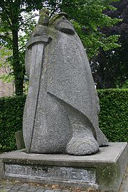
Later, the giant Pier Gerlofs Donia
Pier Gerlofs Donia
Pier Gerlofs Donia was a Frisian warrior, pirate, and rebel. He is best known by his West Frisian nickname "Grutte Pier" , or by the Dutch translations "Grote Pier" and "Lange Pier", or, in Latin, "Pierius Magnus", which referred to his legendary size and strength. His life is mostly shrouded in...
(Grutte Pier) would fight for his country's freedom. He had many successes, but ultimately failed to secure Frisia's independence. He died as a farmer in 1520. A statue dedicated to him is displayed to the right. He is estimated to have been seven feet tall.
Frisian territories
- West FrieslandWest Friesland (historical region)West Friesland is a historical region in the northern part of the Netherlands. It was located in parts of what now is Noord-Holland and the Waddenzee. The region was bordered by the rivers Vlie and IJ...
remained a part of Holland and became a part of North HollandNorth HollandNorth Holland |West Frisian]]: Noard-Holland) is a province situated on the North Sea in the northwest part of the Netherlands. The provincial capital is Haarlem and its largest city is Amsterdam.-Geography:...
around 1800. The current region of West FrieslandWest Friesland (region)West Friesland is a contemporary region in the northwestern Netherlands, in the province of North Holland.The region covers an area of about , delineated by the Westfriese Omringdijk...
is smaller than historical West Friesland and there is also an official constitutional region (samenwerkingsregio) of West Friesland for coast protection, the police, and agriculture. - FrieslandFrieslandFriesland is a province in the north of the Netherlands and part of the ancient region of Frisia.Until the end of 1996, the province bore Friesland as its official name. In 1997 this Dutch name lost its official status to the Frisian Fryslân...
got its independence back (with constitutionalized farmer representation) in 1581 and gave it up again in 1795. It is now a Dutch province. - East FrisiaEast FrisiaEast Frisia or Eastern Friesland is a coastal region in the northwest of the German federal state of Lower Saxony....
became a part of the Kingdom of PrussiaKingdom of PrussiaThe Kingdom of Prussia was a German kingdom from 1701 to 1918. Until the defeat of Germany in World War I, it comprised almost two-thirds of the area of the German Empire...
and was formerly a district of the federal state of Lower SaxonyLower SaxonyLower Saxony is a German state situated in north-western Germany and is second in area and fourth in population among the sixteen states of Germany...
in the Federal Republic of Germany. - GroningenGroningen (province)Groningen [] is the northeasternmost province of the Netherlands. In the east it borders the German state of Niedersachsen , in the south Drenthe, in the west Friesland and in the north the Wadden Sea...
has been a province of the Netherlands since the 16th century. - North FrisiaNorth FrisiaNorth Frisia or Northern Friesland is the northernmost portion of Frisia, located primarily in Germany between the rivers Eider and Wiedau/Vidå. It includes a number of islands, e.g., Sylt, Föhr, Amrum, Nordstrand, and Heligoland.-History:...
was a part of the Danish duchy of SchleswigSchleswigSchleswig or South Jutland is a region covering the area about 60 km north and 70 km south of the border between Germany and Denmark; the territory has been divided between the two countries since 1920, with Northern Schleswig in Denmark and Southern Schleswig in Germany...
(also: Southern JutlandSouthern JutlandSouthern Jutland is the name for the region south of the Kongeå in Jutland, Denmark. The region north of the Kongeå is called Nørrejylland . Both territories had their own ting assemblies in the Middle Ages . South Jutland is mentioned for the first time in the Knýtlinga saga.In the 13th century...
) and belongs now to the German state of Schleswig-HolsteinSchleswig-HolsteinSchleswig-Holstein is the northernmost of the sixteen states of Germany, comprising most of the historical duchy of Holstein and the southern part of the former Duchy of Schleswig...
. - The Frisian islands off the coast of the Netherlands and Germany are the leftover dunes of flooded lands.
Flag
Groep fan auwerk
The Groep fan Auwerk is an organisation that struggles for an independent Greater Frisia. The land that covers the Greater Frisia region, according the Groep fan Auwerk , comprises four parts as expressed in the Pan-Frisian flag advocated by the group:...
, which supports a united Frisia as a recognised country.
The flag is inspired by the Nordic Cross Flag
Nordic Cross Flag
The Nordic Cross Flag, Nordic Cross, or Scandinavian Cross is a pattern of flags usually associated with the flags of the Scandinavian countries of which it originated. All of the Nordic countries except Greenland have adopted such flags...
. The four pompeblêden (water lily leaves) are derived from the seven pompeblêden on the (West) Friesland
Friesland
Friesland is a province in the north of the Netherlands and part of the ancient region of Frisia.Until the end of 1996, the province bore Friesland as its official name. In 1997 this Dutch name lost its official status to the Frisian Fryslân...
flag, but the number represents the three separate Frisian regions plus Groningen (Eastlauwersk Fryslân). The flag was not accepted by the Inter-Frisian Council.
Atlas
In November 2009, a Frisian edition of the national BosatlasBosatlas
The Bosatlas is a Dutch atlas. Used in most schools, it remains the best selling atlas in the Netherlands.-History:The atlas was started by Pieter Roelf Bos, a Groningen teacher. The first atlas was published in 1877 with the name Bos' Schoolatlas der geheele aarde . Later editions were named...
, De Bosatlas van Fryslân was published by the Dutch publisher Noordhoff in Groningen, almost 500 pages and 4 kg. This Bosatlas van Fryslân is completely dedicated to the Dutch province of Friesland, with historical and modern maps, aerophotography and background information on hundreds of topics. It also contains a complete set of topographical maps, in the most detailed scale
Scale (map)
The scale of a map is defined as the ratio of a distance on the map to the corresponding distance on the ground.If the region of the map is small enough for the curvature of the Earth to be neglected, then the scale may be taken as a constant ratio over the whole map....
(1:25 000).
See also
- Eala Frya Fresena
- Frise
- Frisian IslandsFrisian IslandsThe Frisian Islands, also known as the Wadden Islands or Wadden Sea Islands, form an archipelago at the eastern edge of the North Sea in northwestern Europe, stretching from the north-west of the Netherlands through Germany to the west of Denmark...
- Frisian languages
- Frisian-Frankish Wars
- FrisiansFrisiansThe Frisians are a Germanic ethnic group native to the coastal parts of the Netherlands and Germany. They are concentrated in the Dutch provinces of Friesland and Groningen and, in Germany, East Frisia and North Frisia, that was a part of Denmark until 1864. They inhabit an area known as Frisia...
- German BightGerman BightGerman Bight is the southeastern bight of the North Sea bounded by the Netherlands and Germany to the south, and Denmark and Germany to the east . To the north and west it is limited by the Dogger Bank. The Bight contains the Frisian and Danish Islands. The Wadden Sea is approximately ten to...
- JutlandJutlandJutland , historically also called Cimbria, is the name of the peninsula that juts out in Northern Europe toward the rest of Scandinavia, forming the mainland part of Denmark. It has the North Sea to its west, Kattegat and Skagerrak to its north, the Baltic Sea to its east, and the Danish–German...
- Wadden SeaWadden SeaThe Wadden Sea is an intertidal zone in the southeastern part of the North Sea. It lies between the coast of northwestern continental Europe and the range of Frisian Islands, forming a shallow body of water with tidal flats and wetlands. It is rich in biological diversity...
External links
- Geofrisia.com – Interfrisian geographical portal
- Map of Frisia at Eurominority.eu