

Zuider Zee
Encyclopedia
The Zuiderzee (ˌzaɪdər ˈzeɪ; , ˈzœydərzeː; old spelling Zuyderzee) was a shallow bay
of the North Sea
in the northwest of the Netherlands
, extending about 100 km (60 miles) inland and at most 50 km (30 miles) wide, with an overall depth of about 4 to 5 metres (13–16 feet) and a coastline of about 300 km (200 miles). It covered 5000 km² (1,930.5 sq mi). Its name means "southern sea" in Dutch, indicating that the origin of the name can be found in Friesland
to the north of the Zuiderzee (also see North Sea
). In the 20th century the majority of the Zuiderzee was closed off from the North Sea (leaving the mouth of the inlet to become part of the Wadden Sea
) and the salt water inlet changed into a fresh water lake called the IJsselmeer
(IJssel
Lake) after the river that drains into it. The river IJssel is an estuary branch of the river Rhine (Dutch: Rijn).
authors. It was much smaller than its later forms and its connection to the main sea was much narrower; it may have been a complex of lakes and marshes and channels, rather than one lake. Over time these lakes gradually eroded their soft peat
shores and spread (a process known as waterwolf
). Some part of this area of water was later called the Vlie; it probably flowed into the sea through what is now the Vlie
stroom channel between the islands of Vlieland
and Terschelling
. The Marsdiep
was once a river (fluvium Maresdeop) which may have been a distributary
of the Vlie
. During the early Middle Ages
this began to change as rising sea levels and storms
started to eat away at the coastal areas which consisted mainly of peatlands. In this period the inlet was referred to as the Almere, indicating it was still more of a lake, but the mouth and size of the inlet were much widened in the 12th century and especially after a disastrous flood in 1282 broke through the barrier dunes near Texel
. The disaster was the making of the little village of Amsterdam
, for seagoing traffic could now make it a rendezvous for the Baltic
trade. The even more massive St. Lucia's flood
occurred 14 December 1287, when the seawalls broke during a storm, killing approximately 50,000 to 80,000 people in the fifth largest flood in recorded history. The name "Zuiderzee" came into general usage around this period.
The size of this inland sea remained largely stable from the 15th century onwards due to improvements in dikes, but when storms pushed North Sea water into the inlet, the Zuiderzee became a volatile cauldron of water, frequently resulting in flooding and the loss of ships. For example, on 18 November 1421, a seawall
at the Zuiderzee dike broke, which flooded 72 villages and killed about 10,000 people. This was the Second St. Elizabeth's Flood: see Sint-Elisabethsvloed (1421).
The Netherlands was part of the First French Empire
between 1810 and 1813. A département was formed in 1811 and named as Zuyderzée
after the Zuiderzee, of which the territory roughly corresponded to the present provinces of North Holland
and Utrecht
.
Zuiderzee hosted the 6-meter and 8-meter sailing
events for the 1928 Summer Olympics
held in neighboring Amsterdam
.

 Around the Zuiderzee many fishing villages grew up and several developed into walled towns with extensive trade connections, in particular Kampen
, a town in Overijssel
, and later also towns in Holland such as Amsterdam
, Hoorn
, and Enkhuizen
. These towns traded at first with ports on the Baltic Sea
, in England, and in the Hanseatic League
, but later also with the rest of the world, when the Netherlands established its colonial empire
. When that lucrative trade
diminished, most of the towns fell back on fishing and some industry
until the 20th century when tourism
became the major source of income. Contained within the Zuiderzee were four small islands, the remains of what were once larger islands or peninsula
s connected to the mainland
. These were Wieringen
, Urk
, Schokland
, and Marken
. The inhabitants of these islands also subsisted mainly on fishing and related industries and still do in the case of Urk and Wieringen. All of these islands are now part of the mainland or connected to it.
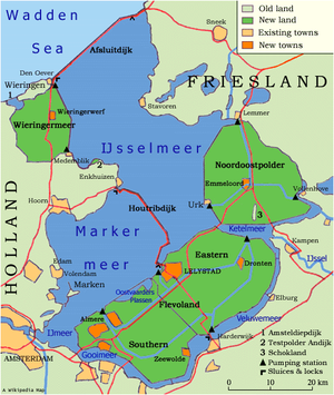
The construction in the early 20th century of a large enclosing dam (the Afsluitdijk
) tamed the Zuiderzee. The creation of this dam was a response to the flood of January 1916. Plans for closing the Zuiderzee had been made over thirty years earlier but had not yet passed in parliament
. With the completion of the Afsluitdijk in 1932, the Zuiderzee became the IJsselmeer
, and large areas of water could be reclaimed for farming and housing. These areas, known as polder
s, were respectively the Wieringermeer
, the Noordoostpolder
, and Flevoland
. This enormous project under the direction of Cornelis Lely
, called the Zuiderzeeworks, ran from 1919 to 1986, culminating in the creation of the new province
of Flevoland
. The reclamation project was originally intended to reclaim the former southwestern portion of the Zuiderzee, a polder that would have been called the Markerwaard
, but this final stage of the reclamation project was indefinitely postponed in the 1980s.
Bay
A bay is an area of water mostly surrounded by land. Bays generally have calmer waters than the surrounding sea, due to the surrounding land blocking some waves and often reducing winds. Bays also exist as an inlet in a lake or pond. A large bay may be called a gulf, a sea, a sound, or a bight...
of the North Sea
North Sea
In the southwest, beyond the Straits of Dover, the North Sea becomes the English Channel connecting to the Atlantic Ocean. In the east, it connects to the Baltic Sea via the Skagerrak and Kattegat, narrow straits that separate Denmark from Norway and Sweden respectively...
in the northwest of the Netherlands
Netherlands
The Netherlands is a constituent country of the Kingdom of the Netherlands, located mainly in North-West Europe and with several islands in the Caribbean. Mainland Netherlands borders the North Sea to the north and west, Belgium to the south, and Germany to the east, and shares maritime borders...
, extending about 100 km (60 miles) inland and at most 50 km (30 miles) wide, with an overall depth of about 4 to 5 metres (13–16 feet) and a coastline of about 300 km (200 miles). It covered 5000 km² (1,930.5 sq mi). Its name means "southern sea" in Dutch, indicating that the origin of the name can be found in Friesland
Friesland
Friesland is a province in the north of the Netherlands and part of the ancient region of Frisia.Until the end of 1996, the province bore Friesland as its official name. In 1997 this Dutch name lost its official status to the Frisian Fryslân...
to the north of the Zuiderzee (also see North Sea
North Sea
In the southwest, beyond the Straits of Dover, the North Sea becomes the English Channel connecting to the Atlantic Ocean. In the east, it connects to the Baltic Sea via the Skagerrak and Kattegat, narrow straits that separate Denmark from Norway and Sweden respectively...
). In the 20th century the majority of the Zuiderzee was closed off from the North Sea (leaving the mouth of the inlet to become part of the Wadden Sea
Wadden Sea
The Wadden Sea is an intertidal zone in the southeastern part of the North Sea. It lies between the coast of northwestern continental Europe and the range of Frisian Islands, forming a shallow body of water with tidal flats and wetlands. It is rich in biological diversity...
) and the salt water inlet changed into a fresh water lake called the IJsselmeer
IJsselmeer
IJsselmeer is a shallow artificial lake of 1100 km² in the central Netherlands bordering the provinces of Flevoland, North Holland and Friesland, with an average depth of 5 to 6 m. The IJsselmeer is the largest lake in Western Europe....
(IJssel
IJssel
River IJssel , sometimes called Gelderse IJssel to avoid confusion with its Hollandse IJssel namesake in the west of the Netherlands, is a branch of the Rhine in the Dutch provinces of Gelderland and Overijssel...
Lake) after the river that drains into it. The river IJssel is an estuary branch of the river Rhine (Dutch: Rijn).
History and disasters
In classical times there was already a body of water in this location, called Lacus Flevo ("Flevo Lake") by RomanRoman Empire
The Roman Empire was the post-Republican period of the ancient Roman civilization, characterised by an autocratic form of government and large territorial holdings in Europe and around the Mediterranean....
authors. It was much smaller than its later forms and its connection to the main sea was much narrower; it may have been a complex of lakes and marshes and channels, rather than one lake. Over time these lakes gradually eroded their soft peat
Peat
Peat is an accumulation of partially decayed vegetation matter or histosol. Peat forms in wetland bogs, moors, muskegs, pocosins, mires, and peat swamp forests. Peat is harvested as an important source of fuel in certain parts of the world...
shores and spread (a process known as waterwolf
Waterwolf
The word waterwolf is a Dutch word for the tendency of lakes in low-lying peaty land to enlarge by flooding and eroding their shores, aided sometimes by men digging peat for fuel. See Haarlemmermeer and Braakman....
). Some part of this area of water was later called the Vlie; it probably flowed into the sea through what is now the Vlie
Vlie
The Vlie or Vliestroom is the seaway between the Dutch islands of Vlieland, to its southwest, and Terschelling, to its northeast. The Vlie was the estuary of the river IJssel in medieval times...
stroom channel between the islands of Vlieland
Vlieland
Vlieland is a municipality in the northern Netherlands. The municipality of Vlieland has only one major town: Oost-Vlieland . It is the second-least densely populated municipality in the Netherlands ....
and Terschelling
Terschelling
Terschelling is a municipality and an island in the northern Netherlands, one of the West Frisian Islands.Waddenislanders are known for their resourcefulness in using anything and everything that washes ashore. With few trees to use for timber, most of the farms and barns are built with masts...
. The Marsdiep
Marsdiep
The Marsdiep is a deep tide-race between Den Helder and Texel in the Netherlands, and running southwards between sandbanks. That gap connects the North Sea and the Waddenzee....
was once a river (fluvium Maresdeop) which may have been a distributary
Distributary
A distributary, or a distributary channel, is a stream that branches off and flows away from a main stream channel. They are a common feature of river deltas. The phenomenon is known as river bifurcation. The opposite of a distributary is a tributary...
of the Vlie
Vlie
The Vlie or Vliestroom is the seaway between the Dutch islands of Vlieland, to its southwest, and Terschelling, to its northeast. The Vlie was the estuary of the river IJssel in medieval times...
. During the early Middle Ages
Middle Ages
The Middle Ages is a periodization of European history from the 5th century to the 15th century. The Middle Ages follows the fall of the Western Roman Empire in 476 and precedes the Early Modern Era. It is the middle period of a three-period division of Western history: Classic, Medieval and Modern...
this began to change as rising sea levels and storms
Floods in the Netherlands
This is a chronological list of floods that have occurred in the Netherlands, until 1500 most parts of the Netherlands were in Frisia.*838 December 26: A large part of the northwest of the Netherlands was flooded by a storm. Lack of good dikes was an important cause of this flood disaster...
started to eat away at the coastal areas which consisted mainly of peatlands. In this period the inlet was referred to as the Almere, indicating it was still more of a lake, but the mouth and size of the inlet were much widened in the 12th century and especially after a disastrous flood in 1282 broke through the barrier dunes near Texel
Texel
Texel is a municipality and an island in the Netherlands, in the province of North Holland. It is the biggest and most populated of the Frisian Islands in the Wadden Sea, and also the westernmost of this archipelago, which extends to Denmark...
. The disaster was the making of the little village of Amsterdam
Amsterdam
Amsterdam is the largest city and the capital of the Netherlands. The current position of Amsterdam as capital city of the Kingdom of the Netherlands is governed by the constitution of August 24, 1815 and its successors. Amsterdam has a population of 783,364 within city limits, an urban population...
, for seagoing traffic could now make it a rendezvous for the Baltic
Baltic Sea
The Baltic Sea is a brackish mediterranean sea located in Northern Europe, from 53°N to 66°N latitude and from 20°E to 26°E longitude. It is bounded by the Scandinavian Peninsula, the mainland of Europe, and the Danish islands. It drains into the Kattegat by way of the Øresund, the Great Belt and...
trade. The even more massive St. Lucia's flood
St. Lucia's flood
St. Lucia's flood was a storm tide that affected the Netherlands and Northern Germany on December 14, 1287 when a dike broke during a storm, killing approximately 50,000 to 80,000 people in the fifth largest flood in recorded history. Much land was permanently flooded in what is now the Waddenzee...
occurred 14 December 1287, when the seawalls broke during a storm, killing approximately 50,000 to 80,000 people in the fifth largest flood in recorded history. The name "Zuiderzee" came into general usage around this period.
The size of this inland sea remained largely stable from the 15th century onwards due to improvements in dikes, but when storms pushed North Sea water into the inlet, the Zuiderzee became a volatile cauldron of water, frequently resulting in flooding and the loss of ships. For example, on 18 November 1421, a seawall
Seawall
A seawall is a form of coastal defence constructed where the sea, and associated coastal processes, impact directly upon the landforms of the coast. The purpose of a seawall is to protect areas of human habitation, conservation and leisure activities from the action of tides and waves...
at the Zuiderzee dike broke, which flooded 72 villages and killed about 10,000 people. This was the Second St. Elizabeth's Flood: see Sint-Elisabethsvloed (1421).
The Netherlands was part of the First French Empire
First French Empire
The First French Empire , also known as the Greater French Empire or Napoleonic Empire, was the empire of Napoleon I of France...
between 1810 and 1813. A département was formed in 1811 and named as Zuyderzée
Zuyderzée
Zuyderzée is the name of a département of the First French Empire in the present Netherlands. It is named after the Zuider Zee sea inlet. It was formed in 1810, when the Kingdom of Holland was annexed by France. Its territory corresponds more or less with the present Dutch provinces North Holland...
after the Zuiderzee, of which the territory roughly corresponded to the present provinces of North Holland
North Holland
North Holland |West Frisian]]: Noard-Holland) is a province situated on the North Sea in the northwest part of the Netherlands. The provincial capital is Haarlem and its largest city is Amsterdam.-Geography:...
and Utrecht
Utrecht (province)
Utrecht is the smallest province of the Netherlands in terms of area, and is located in the centre of the country. It is bordered by the Eemmeer in the north, Gelderland in the east, the river Rhine in the south, South Holland in the west, and North Holland in the northwest...
.
Zuiderzee hosted the 6-meter and 8-meter sailing
Sailing at the 1928 Summer Olympics
Sailing/Yachting is a Olympic sport starting from the Games of the 1st Olympiad . With the exception of 1904 and possible 1916 sailing was always a part of the Olympic program....
events for the 1928 Summer Olympics
1928 Summer Olympics
The 1928 Summer Olympics, officially known as the Games of the IX Olympiad, was an international multi-sport event which was celebrated in 1928 in Amsterdam, Netherlands. Amsterdam had bid for the 1920 and 1924 Olympic Games, but had to give way to war-victim Antwerp, Belgium, and Pierre de...
held in neighboring Amsterdam
Amsterdam
Amsterdam is the largest city and the capital of the Netherlands. The current position of Amsterdam as capital city of the Kingdom of the Netherlands is governed by the constitution of August 24, 1815 and its successors. Amsterdam has a population of 783,364 within city limits, an urban population...
.
Geography and development
Kampen (Overijssel)
Kampen is a municipality, a city and an old Hanseatic city at the lower reaches of the river IJssel in the Dutch province of Overijssel.The municipality of Kampen counts 50,073 inhabitants in an area of approximately 162 km² . Kampen is located in the North West of Overijssel and is the...
, a town in Overijssel
Overijssel
Overijssel is a province of the Netherlands in the central eastern part of the country. The region has a NUTS classification of NL21. The province's name means "Lands across river IJssel". The capital city of Overijssel is Zwolle and the largest city is Enschede...
, and later also towns in Holland such as Amsterdam
Amsterdam
Amsterdam is the largest city and the capital of the Netherlands. The current position of Amsterdam as capital city of the Kingdom of the Netherlands is governed by the constitution of August 24, 1815 and its successors. Amsterdam has a population of 783,364 within city limits, an urban population...
, Hoorn
Hoorn
-Cities :* Purmerend * Enkhuizen * Alkmaar * Amsterdam * Lelystad * Den Helder * Leeuwarden -Towns :* Edam...
, and Enkhuizen
Enkhuizen
Enkhuizen is a municipality and a town in the Netherlands, in the province of North Holland and the region of West-Frisia.Enkhuizen was one of the harbour-towns of the VOC, just like Hoorn and Amsterdam, from where overseas trade with the East Indies was conducted. It received city rights in 1355...
. These towns traded at first with ports on the Baltic Sea
Baltic Sea
The Baltic Sea is a brackish mediterranean sea located in Northern Europe, from 53°N to 66°N latitude and from 20°E to 26°E longitude. It is bounded by the Scandinavian Peninsula, the mainland of Europe, and the Danish islands. It drains into the Kattegat by way of the Øresund, the Great Belt and...
, in England, and in the Hanseatic League
Hanseatic League
The Hanseatic League was an economic alliance of trading cities and their merchant guilds that dominated trade along the coast of Northern Europe...
, but later also with the rest of the world, when the Netherlands established its colonial empire
Dutch Empire
The Dutch Empire consisted of the overseas territories controlled by the Dutch Republic and later, the modern Netherlands from the 17th to the 20th century. The Dutch followed Portugal and Spain in establishing an overseas colonial empire, but based on military conquest of already-existing...
. When that lucrative trade
Trade
Trade is the transfer of ownership of goods and services from one person or entity to another. Trade is sometimes loosely called commerce or financial transaction or barter. A network that allows trade is called a market. The original form of trade was barter, the direct exchange of goods and...
diminished, most of the towns fell back on fishing and some industry
Industry
Industry refers to the production of an economic good or service within an economy.-Industrial sectors:There are four key industrial economic sectors: the primary sector, largely raw material extraction industries such as mining and farming; the secondary sector, involving refining, construction,...
until the 20th century when tourism
Tourism
Tourism is travel for recreational, leisure or business purposes. The World Tourism Organization defines tourists as people "traveling to and staying in places outside their usual environment for not more than one consecutive year for leisure, business and other purposes".Tourism has become a...
became the major source of income. Contained within the Zuiderzee were four small islands, the remains of what were once larger islands or peninsula
Peninsula
A peninsula is a piece of land that is bordered by water on three sides but connected to mainland. In many Germanic and Celtic languages and also in Baltic, Slavic and Hungarian, peninsulas are called "half-islands"....
s connected to the mainland
Mainland
Mainland is a name given to a large landmass in a region , or to the largest of a group of islands in an archipelago. Sometimes its residents are called "Mainlanders"...
. These were Wieringen
Wieringen
Wieringen is a municipality in the Netherlands, in the province of North Holland. It consists of a former island, also named Wieringen, and there are plans to make Wieringen an island again by widening the Amsteldiepkanaal into a lake called the Wieringerrandmeer.-Population centres :The...
, Urk
Urk
Urk is a municipality and a town in the Flevoland province in the central Netherlands.Urk is first mentioned in historical records dating to the 10th century, when it was still an island in the Almere, a lake that would become part of the Zuiderzee in the 13th century after a series of incursions...
, Schokland
Schokland
Schokland is a former island in the Dutch Zuiderzee. Schokland lost its status as an island when the Noordoostpolder was reclaimed from the sea in 1942...
, and Marken
Marken
Marken is a peninsula in the IJsselmeer, the Netherlands, located in the municipality Waterland in the province North Holland. It is an island, which nowadays is connected to the North Holland mainland by a causeway. Also, Marken is a well-known tourist attraction, well-known for its characteristic...
. The inhabitants of these islands also subsisted mainly on fishing and related industries and still do in the case of Urk and Wieringen. All of these islands are now part of the mainland or connected to it.
The construction in the early 20th century of a large enclosing dam (the Afsluitdijk
Afsluitdijk
The Afsluitdijk is a major causeway in the Netherlands, constructed between 1927 and 1933 and running from Den Oever on Wieringen in North Holland province, to the village of Zurich in Friesland province, over a length of and a width of 90 m, at an initial height of 7.25 m above sea-level.It is...
) tamed the Zuiderzee. The creation of this dam was a response to the flood of January 1916. Plans for closing the Zuiderzee had been made over thirty years earlier but had not yet passed in parliament
States-General of the Netherlands
The States-General of the Netherlands is the bicameral legislature of the Netherlands, consisting of the Senate and the House of Representatives. The parliament meets in at the Binnenhof in The Hague. The archaic Dutch word "staten" originally related to the feudal classes in which medieval...
. With the completion of the Afsluitdijk in 1932, the Zuiderzee became the IJsselmeer
IJsselmeer
IJsselmeer is a shallow artificial lake of 1100 km² in the central Netherlands bordering the provinces of Flevoland, North Holland and Friesland, with an average depth of 5 to 6 m. The IJsselmeer is the largest lake in Western Europe....
, and large areas of water could be reclaimed for farming and housing. These areas, known as polder
Polder
A polder is a low-lying tract of land enclosed by embankments known as dikes, that forms an artificial hydrological entity, meaning it has no connection with outside water other than through manually-operated devices...
s, were respectively the Wieringermeer
Wieringermeer
Wieringermeer is a municipality and a polder in the Netherlands, in the province of North Holland.- Population centres :The municipality of Wieringermeer consists of the following cities, towns, villages and/or districts: Kreileroord, Middenmeer, Slootdorp, Wieringerwerf.- History :Around the year...
, the Noordoostpolder
Noordoostpolder
Noordoostpolder is a municipality in the Flevoland province in the central Netherlands. Formerly, it was also called Urker Land. Emmeloord is the administrative center, located in the heart of the Noordoostpolder. The municipality has the largest land area in the Netherlands...
, and Flevoland
Flevoland
Flevoland is a province of the Netherlands. Located in the centre of the country, at the location of the former Zuiderzee, the province was established on January 1, 1986; the twelfth province of the country, with Lelystad as its capital...
. This enormous project under the direction of Cornelis Lely
Cornelis Lely
Cornelis Lely was a Dutch civil engineer and statesman. He first designed and then realised by a law the Zuiderzee Works, a major project that turned the Zuiderzee into a lake, and converting a huge area into dry land.-Career outline:From 1886 to 1891, Lely led the technical research team that...
, called the Zuiderzeeworks, ran from 1919 to 1986, culminating in the creation of the new province
Provinces of the Netherlands
A Dutch province represents the administrative layer in between the national government and the local municipalities, having the responsibility for matters of subnational or regional importance. The government of each province consists of three major parts: the Provinciale Staten which is the...
of Flevoland
Flevoland
Flevoland is a province of the Netherlands. Located in the centre of the country, at the location of the former Zuiderzee, the province was established on January 1, 1986; the twelfth province of the country, with Lelystad as its capital...
. The reclamation project was originally intended to reclaim the former southwestern portion of the Zuiderzee, a polder that would have been called the Markerwaard
Markerwaard
thumb | right | 250px | The Markerwaard is visible on [[Cornelis Lely | Lely]]'s planThe Markerwaard is the name of a polder in the IJsselmeer that was never built and would result as the total or partial reclamation of the Markermeer...
, but this final stage of the reclamation project was indefinitely postponed in the 1980s.
External links
- The Zuiderzee Museum (www.zuiderzeemuseum.nl), dedicated to the history and culture of the former Zuiderzee.
Multimedia
- CBC Archives Matthew HaltonMatthew HaltonMatthew Henry Halton was a Canadian television journalist, most famous as a foreign correspondent for the Canadian Broadcasting Corporation during World War II....
of CBC Radio (19 April 1945) reports on German destruction of the sea walls. - Pathe newsreel of flooding, 1916