
February 2009 tornado outbreak
Encyclopedia
The February 2009 tornado outbreak primarily affected portions of the South Central United States
on February 10, as well as sections of the Northeastern United States
, on February 11. During the two-day period, 15 tornadoes touched down in seven states. Oklahoma
was struck by six tornadoes, the most of any state. The first day of the outbreak produced the most tornado
es; the second brought mainly high wind damage and rain or snow in most of the Northeast.
The storm system responsible for the tornado outbreak resulted from the unusual congruence of a cold, dry system, originating in the Four Corners and a warm, moist system, moving north out of Texas
. Complicating factors included daytime heating and a strong wind field favorable to the creation of circulating thunderstorms. On the second day, the stronger cold front limited discrete supercell
activity and the risk of tornadoes decreased significantly. A squall line
, however, produced high winds and rain along the river valleys, primarily those of the Mississippi
and Ohio River
s. This squall line continued to renew its energy as it passed through the Midwest
, Pennsylvania
, New Jersey
, New York
, and New England
, causing wind and water damage, and dumping 6 inches (15.2 cm) of snow in central and eastern Massachusetts
. The resulting power outages affected homes throughout the northeastern seaboard.
The most destructive of the weather events, an EF4
tornado now called the Lone Grove Tornado, travelled for nearly an hour through four counties in Oklahoma during the evening of February 10. It destroyed 114 residences in Lone Grove
alone. Eight people died and 46 others were injured as a result of the Lone Grove Tornado. It was the deadliest tornado to hit Oklahoma since May 3, 1999 and the strongest tornado during the month of February in Oklahoma since 1950.
. A moist, low-level air mass
streamed northward across Texas
and Louisiana
into eastern Oklahoma
and the Ozarks ahead of the system. Daytime heating of the moistening boundary layer
increased throughout the afternoon across Oklahoma and Texas as cloud cover shifted eastward. Cooling aloft, in conjunction with the approaching storm system, led to atmospheric instability
, resulting in thunderstorms. A very strong wind field increased with height through the lower troposphere
, resulting in a wind shear
favorable for rotation in the thunderstorms.
Meteorologists expected large hail
stones and damaging winds, and recognized the potential for strong tornadoes as thunderstorms developed from central Oklahoma southward into north-central Texas in the afternoon. During the night, a cold front
moved eastward toward the Mississippi Valley and organized the thunderstorms into a lengthy squall line
. Along with a continued threat of hail and tornadoes, the risk of damaging winds increased. The Storm Prediction Center
announced a "moderate risk" of severe weather for portions of eastern Oklahoma, northeastern Texas, western Arkansas
, and northwestern Louisiana.
At around 1:00 pm CST (19:00 UTC
), a line of violent thunderstorms began developing near the Wichita Mountains
in Comanche County, Oklahoma
. The supercell
that eventually produced the first tornado of the outbreak moved northeast through Caddo
and Grady
counties over the next 30 to 45 minutes, before reaching southeastern Canadian County
at around 2:00 pm CST (20:00 UTC). By 2:14 pm CST (20:14 UTC), the line had formed a hook echo
, which was fully developed four minutes later. Observers reported wall cloud
s from the Yukon
area into western portions of Oklahoma City
during the next 10 to 15 minutes. At 2:36 pm CST (20:37 UTC), the supercell produced a tornado near the Wiley Post Airport
in Oklahoma City
, causing damage at the Northwest Expressway. According to the Doppler
weather radar
, the hook continued to show signs of rotation as it moved northeast across Oklahoma County
. At 2:52 pm CST (20:52 UTC), the supercell produced its second tornado on the northwestern side of Edmond
which caused its most severe damage near the Oklahoma and Logan County
line. The tornado dissipated north of the Logan County Line at 3:05 pm CST (21:05 UTC).
The supercell produced three more tornadoes in Oklahoma as it continued to move northeast. The third tornado occurred northwest of Meridian
in Logan County at 3:26 pm CST (21:36 UTC). A fourth developed near Langston
in Logan County and moved to about 4 mi (6.4 km) southwest of Stillwater
in Payne County
. The fifth tornado occurred in Pawnee County
. In addition to the five Oklahoma tornadoes, three tornadoes struck northern sections of Texas and one tornado hit Springfield, Missouri
.
The most significant tornado, later named the Lone Grove Tornado, first touched down in southeast Jefferson County, Oklahoma
at 6:48 pm CST (00:48 UTC) near the Red River
. The tornado crossed through rural areas as it moved to the northeast into Love County
, before going into Carter County
at 7:10 pm CST (01:10 UTC). The tornado continued moving to the northeast for the next 15 minutes before striking Lone Grove, Oklahoma
. The tornado then crossed Interstate 35
just north of the Prairie Valley Road exit ramp and tracked through rural areas of northeastern Carter County to the east of Springer
, ending at 7:43 pm CST (01:43 UTC).
The Storm Prediction Center issued a slight risk warning for February 11. The warning included parts of the Deep South
, Ohio Valley, Midwest
, and Appalachians. The risk of tornadoes was lower on February 11 due to a stronger front
, which limited discrete supercell activity and decreased atmospheric instability. The "slight risk" was later upgraded to a "moderate risk" as a powerful squall line
developed.
, along the Texas-Oklahoma border. It crossed through Jefferson and Love counties before entering Carter County where it proceeded to slam into Lone Grove
. The tornado dissipated at 7:43 pm CST (01:43 UTC) after remaining on the ground for nearly an hour and traveling an estimated 35 mi (56.3 km). After an assessment by the National Weather Service
office in Norman, Oklahoma
, the tornado was rated as an EF4 on the Enhanced Fujita Scale
with winds reaching an estimated 170 mph (273.6 km/h).
The Lone Grove Tornado was the deadliest to hit Oklahoma since May 3, 1999, and the strongest tornado during the month of February in Oklahoma since 1950. The previous strongest were two F3 tornadoes which touched down on February 17, 1961.
The tornado destroyed businesses and residences across a swath over 0.5 mi (0.80467 km) wide and 35 mi (56.3 km) long. In Lone Grove alone, buildings were thrown off their slabs and the local chamber of commerce office was flattened. The tornado destroyed a furniture store, and shattered the glass lobby of the local UPS
building. The destruction of a mobile home park containing 40 homes left close to 100 people homeless. One mobile home was thrown 100 yd (91.4 m) from its foundation. A total of 114 residences were destroyed in Lone Grove.
To the east of Lone Grove, the area north of Ardmore
was also hard hit. Several buildings, including those of the Beaver Academy and the Ardmore Adventist Academy, were destroyed. Although damage centered on the Ardmore Academy gymnasium, most of the campus was considered a total loss. In Ardmore, eight homes were destroyed and another 20 sustained damage.
Eight people were confirmed dead as a result of the tornado. Seven of these fatalities were in the town of Lone Grove; most were determined to have been caused by “blunt-force trauma to the head". Three of the victims were found inside their homes and two were found outside. A victim found in an open field was reportedly picked up and thrown by the tornado, and died on impact with the ground. One victim was crushed when a pickup truck fell on him; similarly, a truck driver died after being pinned under his vehicle on Interstate 35
. Two other victims, the parents of a 13-year old girl, were killed when the tornado picked the three of them out of their home and threw them 400 ft (121.9 m). Three people were rescued after being trapped in the ruins of their home for almost a day. Officials stated that 10 to 15 people remained unaccounted for on the night of February 12 but they were presumed to have left the area. An additional 46 people were injured. Total monetary damages from the tornado were estimated at $3 million.
in central Texas. Meteorologists predicted embedded supercell thunderstorms that could produce hail up to 2.5 inches (6.4 cm) in diameter and wind gusts up to 90 mph (144.8 km/h). North of the squall line, bow echo
thunderstorms developed in Missouri, causing widespread wind damage. By the morning of February 11, the squall line reached as far southeast as eastern Louisiana, where winds were recorded in excess of 70 mph (112.7 km/h) along with hail up to 1 inches (2.5 cm) in diameter. Around 12 pm EST (17:00 UTC), the first line of thunderstorms significantly weakened, but a new, narrow line developed in eastern Kentucky and Tennessee. A strong, deep layer wind field prevented a number of tornadoes from forming but instead caused widespread wind damage. Throughout the day, the line of low-topped thunderstorms continued eastward, reaching Ohio and West Virginia by 4 pm EST (21:00 UTC). Several hours later, the line broke apart, with the strongest storms tracking through Pennsylvania. By February 12, rain showers, accompanied by high winds up to 60 mph (96.6 km/h), affected most of the Northeastern United States.
also produced damage in the state, with one bolt striking an oil tank, igniting a fire. The fire severely damaged the tank, leaving $13,000 in damages. Throughout the state, an estimated 61,000 people lost power: 29,000 lost power due to thunderstorms and 32,000 due to tornadoes. In Mississippi, strong winds on the backside of the cold front blew a metal roof off a power company building, bringing down several trees and power lines. Damages in the state amounted to $35,000.
was broken off its moorings and moved 20 ft (6.1 m). Several mobile homes near Hamilton
sustained damage after tree limbs fell on them. In Huron, several outbuildings were damaged or destroyed and a permanent building was damaged at a youth retreat center. An estimated 15,000 residences were without power following the storms in Texas. One home in McGregor
was destroyed by the winds. The three people who lived in the home, one of whom was a child, all sustained injuries. The father had a few broken ribs and several scratches, injuries sustained during a search for his son. In Louisiana, 12,000 residences lost power due to the storm system. Two wildfires were sparked in Kenedy County and Kleberg County, burning 300 and 20 acre (121.4 and 8.1 ) respectively. The larger of the two fires was along Texas State Highway 77. The second fire burned three homes and threatened 20 others.
. Hundreds of trees were blown down, many of which fell on homes, causing widespread damage which amounted to approximately $625,000. In Conway County, a sawmill and two barns were destroyed, while several homes and a church also sustained damage, mainly roof damage. Damages in the county were estimated at $300,000. Numerous homes sustained wind damage and two mobile homes and a recreational vehicle were overturned. Damages in the county were estimated at $750,000. Total damages throughout the state were estimated at $2.4 million. Seven people sustained injuries in the state.
, a the high winds destroyed a brick house and brought down power lines. The most significant damage resulted from the strong pressure gradient behind the frontal system. Thousands of tree were knocked down or uprooted by winds gusting in excess of 75 mph (120.7 km/h), cutting power to 585,775 residences. Ten railroad cars were knocked off their tracks near Shelby
. Several hundred homes lost shingles and gutters due to the winds. Wind also overturned two semi-trailers
, though the drivers of both vehicles were unharmed. A vacant school building in Epworth lost its entire roof. Some windows were damaged or broken by flying debris or fallen trees. Power outages forced numerous schools to close for at least two days following the storm. A large barn was leveled just north of Brighton
in Lorain County by 64 mph (103 km/h) winds. Throughout the state, damages from the storm system amounted to $4.7 million.
, a car carrying four people lost control on rain-slicked roads and crashed into a van, killing one of the occupants and injuring the other three. Another fatality occurred in Kentucky when a utility worker was knocked over by high winds and fell 30 ft (9.1 m) to his death while trying to restore power. Following the widespread power outages from a severe ice storm
, an additional 161,588 residences lost power due to 60 mph (96.6 km/h) winds. Flooding and high winds in Michigan knocked out power to about 57,000 residences. In southern Michigan, upwards of 0.8 inches (2 cm) of rain fell, leading to faster snowmelt. In Tennessee, several structures were damaged and numerous trees were knocked down, closing roads throughout the state as the squall line tracked eastward. A total of 74,052 residences lost power due to the winds. Winds gusting up to 85 mph (136.8 km/h) caused substantial damage in Rutherford County
. Several commercial buildings had major roof damage, leaving $150,000 in damages. Throughout Tennessee, damages from the storm system were estimated at $1.1 million.
, leaving $50,000 in damages. In the town of Carmel
, a total of 2.75 inches (69.9 mm) of rain fell, the highest in the state. The heavy rains, in combination with unseasonably warm temperatures, led to significant snowmelt and flooding. The highest wind gust recorded in the state was 80 mph (128.7 km/h) in Crawford County
. A total of 70,695 residences lost power in Illinois. Rainfall up to 4 inches (101.6 mm) fell throughout most of the state. Several major roadways were covered in flood waters. The Little Wabash River
overflowed its banks and inundated nearby roads. Along Illinois Route 1
, a large tree blocked a section of the road near Georgetown
. The fallen tree resulted in a vehicle accident but the driver was unharmed. One person was killed by high winds in Davy, West Virginia
when a gymnasium roof collapsed. Throughout the state, power was knocked out to an estimated 225,000 residences. In Montgomery County, Virginia
, winds knocked down power lines which sparked two brush fires, one of which burned a total of 12 acres (4.9 ha). Winds up to 65 mph (104.6 km/h) cut power to 28,059 residences in the state. The strong winds also cut power to 50,820 residences in Maryland.
wind gusts up to 92 mph (148.1 km/h) caused significant damage and power losses in Pennsylvania. Throughout the state, at least 400,000 residences lost power due to the winds. Allegheny Power stated that the loss of power due to this system was the largest ever experienced by the company. Thousands of trees and power lines were brought down by strong winds and numerous homes sustained significant damage. Although most of the damage to homes consisted of shingle damage, several homes lost gutters and had portions of their siding blown off.
In Pottstown
, a large portion of the roof of a four-story building was blown off, forcing residents to evacuate the building. An 18 ft (5.5 m) pillar was knocked down at the First Moravian Church in Easton
. In Northampton County
, a fire sparked by fallen power lines destroyed a barn and partially melted a nearby metal shed. The blaze was fully contained by 40 firefighters. Another fire sparked by fallen power lines destroyed a garage in Lower Merion Township
. In Philadelphia, the roof of a portable classroom began to peel off, forcing the forty students inside to evacuate to a safer structure. A large tree fell through one house and severely damaged the roof of a nearby home. Numerous major highways and local streets were shut down for several hours to allow cleanup crews to clear debris. Throughout the state, damages from the storm system amounted to $3.7 million.
, an estimated 2 to 5 in (5.1 to 12.7 cm) of the snowpack melted, triggering flash floods along several rivers. The Tonawanda Creek
reached a height of 14.38 ft (4.4 m), 2.38 ft (0.725424 m) above flood stage. Several homes were inundated by flood waters throughout the region. In all, 84,624 residences lost power in New York State. The storm system continued producing gusty winds through February 12, which caused tree damage and power outages, and killed a construction worker in the New York City metropolitan area. The construction worker was killed after a cinder block wall collapsed due to high-winds. Winds in the city gusted to 65 mph (104.6 km/h) in the Bronx. Throughout Long Island, an estimated 4,000 people lost power.
, burning a total of 40 acres (16.2 ha). A total of 8,486 Connecticut residences were left without power and one boy was injured after high winds damaged numerous power lines and tree limbs. In Massachusetts, gusts up to 55 mph (88.5 km/h) brought down several trees and cut power to residences in Middleborough
, Boston, Brookline
and Hingham
. The Western Massachusetts Electric Company
reported that at least 360 residences lost power during the storm. Moderate snow fell across portions of The Berkshires
late on February 12 as the storm system began entering the Atlantic Ocean
, while isolated areas received upwards of 6 inches (15.2 cm).
opened shelters in Ardmore, Edmond, and Oklahoma City. About 100 volunteers from the Sorghum Mill Estates Neighborhood Association traveled to affected areas in Edmond to help with cleanup efforts. A local restaurant provided free meals to the volunteers as they assisted relief workers. The Salvation Army
had two canteens in Oklahoma City, one in Lone Grove, and one in Perkins
. About 2,000 meals, drinks, and snacks were provided by the Salvation Army to emergency responders. Feed the Children
sent two truckloads of relief supplies to Carter County
. They also sent three food trucks, containing a total of 619 meals, 900 drinks, and about 500 snacks, to Ardmore. On February 22, the New Life Baptist Church sent drinks and prepackaged snacks, along with items needed for clean-up. Baptist Disaster Relief assisted in Lone Grove with food and emotional care. The Oklahoma City Thunder
of the National Basketball Association
(NBA) gave away two tickets to anyone who made a donation of $25 or an equivalent amount of food to benefit victims of the tornado. A concert featuring Chris Cagle
and other local musicians at Heritage Hall in Ardmore raised over $18,000 to benefit Carter County tornado victims. Another concert set up by the Salvation Army raised $2,300 more for victims.
The Governor of Oklahoma Brad Henry
declared a State of Emergency
in 17 counties and described the outbreak as the worst natural disaster he had seen since becoming governor. On February 15, President Obama approved Henry's request for federal assistance in Carter, Logan and Oklahoma counties. A disaster recovery center was set up by the Federal Emergency Management Agency
(FEMA) on February 20. Homeowners were allowed to borrow $200,000 to repair damages to their home or find a temporary or permanent shelter. They were also allowed to borrow up to $40,000 to replace lost property. Businesses were allowed to borrow up to $2 million for damage repair, property loss, and economic loss. By February 23, about $781,000 had been given in federal grants. On February 25, FEMA approved Governor Henry's request for public assistance in Carter, Coal
and Love counties. The estimated cost to clear the 7,000 tons of debris in Lone Grove was placed at $500,000, of which $90,000 has been paid for by FEMA. The Department of Homeland Security
offered to assist with the reconstruction of homes and businesses and to support those who were left homeless. President Barack Obama
passed along his condolences and best wishes to the victims of the tornado.
South Central United States
The South Central United States or South Central states is a region of the United States located in the south central part of the country. It evolved out of the archaic southwest, which originally was literally the western U.S. South...
on February 10, as well as sections of the Northeastern United States
Northeastern United States
The Northeastern United States is a region of the United States as defined by the United States Census Bureau.-Composition:The region comprises nine states: the New England states of Connecticut, Maine, Massachusetts, New Hampshire, Rhode Island and Vermont; and the Mid-Atlantic states of New...
, on February 11. During the two-day period, 15 tornadoes touched down in seven states. Oklahoma
Oklahoma
Oklahoma is a state located in the South Central region of the United States of America. With an estimated 3,751,351 residents as of the 2010 census and a land area of 68,667 square miles , Oklahoma is the 28th most populous and 20th-largest state...
was struck by six tornadoes, the most of any state. The first day of the outbreak produced the most tornado
Tornado
A tornado is a violent, dangerous, rotating column of air that is in contact with both the surface of the earth and a cumulonimbus cloud or, in rare cases, the base of a cumulus cloud. They are often referred to as a twister or a cyclone, although the word cyclone is used in meteorology in a wider...
es; the second brought mainly high wind damage and rain or snow in most of the Northeast.
The storm system responsible for the tornado outbreak resulted from the unusual congruence of a cold, dry system, originating in the Four Corners and a warm, moist system, moving north out of Texas
Texas
Texas is the second largest U.S. state by both area and population, and the largest state by area in the contiguous United States.The name, based on the Caddo word "Tejas" meaning "friends" or "allies", was applied by the Spanish to the Caddo themselves and to the region of their settlement in...
. Complicating factors included daytime heating and a strong wind field favorable to the creation of circulating thunderstorms. On the second day, the stronger cold front limited discrete supercell
Supercell
A supercell is a thunderstorm that is characterized by the presence of a mesocyclone: a deep, continuously-rotating updraft. For this reason, these storms are sometimes referred to as rotating thunderstorms...
activity and the risk of tornadoes decreased significantly. A squall line
Squall line
A squall line is a line of severe thunderstorms that can form along or ahead of a cold front. In the early 20th century, the term was used as a synonym for cold front. It contains heavy precipitation, hail, frequent lightning, strong straight-line winds, and possibly tornadoes and waterspouts....
, however, produced high winds and rain along the river valleys, primarily those of the Mississippi
Mississippi River
The Mississippi River is the largest river system in North America. Flowing entirely in the United States, this river rises in western Minnesota and meanders slowly southwards for to the Mississippi River Delta at the Gulf of Mexico. With its many tributaries, the Mississippi's watershed drains...
and Ohio River
Ohio River
The Ohio River is the largest tributary, by volume, of the Mississippi River. At the confluence, the Ohio is even bigger than the Mississippi and, thus, is hydrologically the main stream of the whole river system, including the Allegheny River further upstream...
s. This squall line continued to renew its energy as it passed through the Midwest
Midwestern United States
The Midwestern United States is one of the four U.S. geographic regions defined by the United States Census Bureau, providing an official definition of the American Midwest....
, Pennsylvania
Pennsylvania
The Commonwealth of Pennsylvania is a U.S. state that is located in the Northeastern and Mid-Atlantic regions of the United States. The state borders Delaware and Maryland to the south, West Virginia to the southwest, Ohio to the west, New York and Ontario, Canada, to the north, and New Jersey to...
, New Jersey
New Jersey
New Jersey is a state in the Northeastern and Middle Atlantic regions of the United States. , its population was 8,791,894. It is bordered on the north and east by the state of New York, on the southeast and south by the Atlantic Ocean, on the west by Pennsylvania and on the southwest by Delaware...
, New York
New York
New York is a state in the Northeastern region of the United States. It is the nation's third most populous state. New York is bordered by New Jersey and Pennsylvania to the south, and by Connecticut, Massachusetts and Vermont to the east...
, and New England
New England
New England is a region in the northeastern corner of the United States consisting of the six states of Maine, New Hampshire, Vermont, Massachusetts, Rhode Island, and Connecticut...
, causing wind and water damage, and dumping 6 inches (15.2 cm) of snow in central and eastern Massachusetts
Massachusetts
The Commonwealth of Massachusetts is a state in the New England region of the northeastern United States of America. It is bordered by Rhode Island and Connecticut to the south, New York to the west, and Vermont and New Hampshire to the north; at its east lies the Atlantic Ocean. As of the 2010...
. The resulting power outages affected homes throughout the northeastern seaboard.
The most destructive of the weather events, an EF4
Enhanced Fujita Scale
The Enhanced Fujita Scale rates the strength of tornadoes in the United States based on the damage they cause.Implemented in place of the Fujita scale introduced in 1971 by Ted Fujita, it began operational use on February 1, 2007. The scale has the same basic design as the original Fujita scale:...
tornado now called the Lone Grove Tornado, travelled for nearly an hour through four counties in Oklahoma during the evening of February 10. It destroyed 114 residences in Lone Grove
Lone Grove, Oklahoma
Lone Grove is a city in Carter County, Oklahoma, United States. The population was 4,631 at the 2000 census. It is part of the Micropolitan Statistical Area of Ardmore.The city, located seven miles west of Ardmore on U.S...
alone. Eight people died and 46 others were injured as a result of the Lone Grove Tornado. It was the deadliest tornado to hit Oklahoma since May 3, 1999 and the strongest tornado during the month of February in Oklahoma since 1950.
Storm development
During the afternoon hours of February 10, 2009, a strong, middle and upper storm system moved across the Four Corners region into the central and southern Great PlainsGreat Plains
The Great Plains are a broad expanse of flat land, much of it covered in prairie, steppe and grassland, which lies west of the Mississippi River and east of the Rocky Mountains in the United States and Canada. This area covers parts of the U.S...
. A moist, low-level air mass
Air mass
In meteorology, an air mass is a volume of air defined by its temperature and water vapor content. Air masses cover many hundreds or thousands of square miles, and adopt the characteristics of the surface below them. They are classified according to latitude and their continental or maritime...
streamed northward across Texas
Texas
Texas is the second largest U.S. state by both area and population, and the largest state by area in the contiguous United States.The name, based on the Caddo word "Tejas" meaning "friends" or "allies", was applied by the Spanish to the Caddo themselves and to the region of their settlement in...
and Louisiana
Louisiana
Louisiana is a state located in the southern region of the United States of America. Its capital is Baton Rouge and largest city is New Orleans. Louisiana is the only state in the U.S. with political subdivisions termed parishes, which are local governments equivalent to counties...
into eastern Oklahoma
Oklahoma
Oklahoma is a state located in the South Central region of the United States of America. With an estimated 3,751,351 residents as of the 2010 census and a land area of 68,667 square miles , Oklahoma is the 28th most populous and 20th-largest state...
and the Ozarks ahead of the system. Daytime heating of the moistening boundary layer
Planetary boundary layer
The planetary boundary layer , also known as the atmospheric boundary layer , is the lowest part of the atmosphere and its behavior is directly influenced by its contact with a planetary surface. On Earth it usually responds to changes in surface forcing in an hour or less...
increased throughout the afternoon across Oklahoma and Texas as cloud cover shifted eastward. Cooling aloft, in conjunction with the approaching storm system, led to atmospheric instability
Atmospheric instability
Atmospheric instability is a condition where the atmosphere is generally considered to be unstable and as a result the weather is subject to a high degree of variability through distance and time...
, resulting in thunderstorms. A very strong wind field increased with height through the lower troposphere
Troposphere
The troposphere is the lowest portion of Earth's atmosphere. It contains approximately 80% of the atmosphere's mass and 99% of its water vapor and aerosols....
, resulting in a wind shear
Wind shear
Wind shear, sometimes referred to as windshear or wind gradient, is a difference in wind speed and direction over a relatively short distance in the atmosphere...
favorable for rotation in the thunderstorms.
Meteorologists expected large hail
Hail
Hail is a form of solid precipitation. It consists of balls or irregular lumps of ice, each of which is referred to as a hail stone. Hail stones on Earth consist mostly of water ice and measure between and in diameter, with the larger stones coming from severe thunderstorms...
stones and damaging winds, and recognized the potential for strong tornadoes as thunderstorms developed from central Oklahoma southward into north-central Texas in the afternoon. During the night, a cold front
Cold front
A cold front is defined as the leading edge of a cooler mass of air, replacing a warmer mass of air.-Development of cold front:The cooler and denser air wedges under the less-dense warmer air, lifting it...
moved eastward toward the Mississippi Valley and organized the thunderstorms into a lengthy squall line
Squall line
A squall line is a line of severe thunderstorms that can form along or ahead of a cold front. In the early 20th century, the term was used as a synonym for cold front. It contains heavy precipitation, hail, frequent lightning, strong straight-line winds, and possibly tornadoes and waterspouts....
. Along with a continued threat of hail and tornadoes, the risk of damaging winds increased. The Storm Prediction Center
Storm Prediction Center
The Storm Prediction Center , located in Norman, Oklahoma, is tasked with forecasting the risk of severe thunderstorms and tornadoes in the contiguous United States. The agency issues convective outlooks, mesoscale discussions, and watches as a part of this process...
announced a "moderate risk" of severe weather for portions of eastern Oklahoma, northeastern Texas, western Arkansas
Arkansas
Arkansas is a state located in the southern region of the United States. Its name is an Algonquian name of the Quapaw Indians. Arkansas shares borders with six states , and its eastern border is largely defined by the Mississippi River...
, and northwestern Louisiana.
At around 1:00 pm CST (19:00 UTC
Coordinated Universal Time
Coordinated Universal Time is the primary time standard by which the world regulates clocks and time. It is one of several closely related successors to Greenwich Mean Time. Computer servers, online services and other entities that rely on having a universally accepted time use UTC for that purpose...
), a line of violent thunderstorms began developing near the Wichita Mountains
Wichita Mountains
The Wichita Mountains are located in the southwestern portion of the U.S. state of Oklahoma. The mountains are a northwest-southeast trending series of rocky promontories, many capped by 540 million-year old granite. These were exposed and rounded by weathering during the Permian Period...
in Comanche County, Oklahoma
Comanche County, Oklahoma
Comanche County is a county located in the U.S. state of Oklahoma. Built on former reservation lands of the Comanche, Kiowa, and Apache in Indian Territory, Comanche County was open for settlement on August 16, 1901 by lottery. The region has three cities and seven towns as well as the Fort Sill...
. The supercell
Supercell
A supercell is a thunderstorm that is characterized by the presence of a mesocyclone: a deep, continuously-rotating updraft. For this reason, these storms are sometimes referred to as rotating thunderstorms...
that eventually produced the first tornado of the outbreak moved northeast through Caddo
Caddo County, Oklahoma
Caddo County is a county located in the U.S. state of Oklahoma. As of 2000, the population was 30,150. Its county seat is Anadarko. It is named after the Caddo tribe who were settled here on the 1870s...
and Grady
Grady County, Oklahoma
Grady County is a county located in the U.S. state of Oklahoma. As of 2006, the population was 50,490. Its county seat is Chickasha.Grady County is part of the Oklahoma City Metropolitan Statistical Area.-History:...
counties over the next 30 to 45 minutes, before reaching southeastern Canadian County
Canadian County, Oklahoma
Canadian County is a county located in the U.S. state of Oklahoma. As of 2010, the population was 115,541. Its county seat is El Reno. Canadian County is also part of the Oklahoma City Metropolitan Statistical Area. Canadian County is named for the Canadian River.-Geography:According to the U.S...
at around 2:00 pm CST (20:00 UTC). By 2:14 pm CST (20:14 UTC), the line had formed a hook echo
Hook echo
The hook echo is one of the classical hallmarks of tornado-producing supercell thunderstorms as seen on a weather radar. The echo is produced by rain, hail, or even debris being wrapped around the supercell...
, which was fully developed four minutes later. Observers reported wall cloud
Wall cloud
A wall cloud is a large, lowering, and rotating base of a cumulonimbus cloud that potentially forms tornadoes. It is typically beneath the rain-free base portion of a deep cumulus cloud , and indicates the area of primary and strongest updraft which condenses into cloud at altitudes lower than...
s from the Yukon
Yukon, Oklahoma
Yukon is a city in Canadian County, Oklahoma, United States and is part of the Oklahoma City Metropolitan Area. The population was 22,709 at the 2010 census....
area into western portions of Oklahoma City
Oklahoma city
Oklahoma City is the capital and largest city of the U.S. state of Oklahoma.Oklahoma City may also refer to:*Oklahoma City metropolitan area*Downtown Oklahoma City*Uptown Oklahoma City*Oklahoma City bombing*Oklahoma City National Memorial...
during the next 10 to 15 minutes. At 2:36 pm CST (20:37 UTC), the supercell produced a tornado near the Wiley Post Airport
Wiley Post Airport
Wiley Post Airport is a city-owned public-use airport located seven nautical miles northwest of the central business district of Oklahoma City, in Oklahoma County, Oklahoma, United States....
in Oklahoma City
Oklahoma city
Oklahoma City is the capital and largest city of the U.S. state of Oklahoma.Oklahoma City may also refer to:*Oklahoma City metropolitan area*Downtown Oklahoma City*Uptown Oklahoma City*Oklahoma City bombing*Oklahoma City National Memorial...
, causing damage at the Northwest Expressway. According to the Doppler
Pulse-doppler radar
Pulse-Doppler is a 4D radar system capable of detecting both target 3D location as well as measuring radial velocity . It uses the Doppler effect to avoid overloading computers and operators as well as to reduce power consumption...
weather radar
Weather radar
Weather radar, also called weather surveillance radar and Doppler weather radar, is a type of radar used to locate precipitation, calculate its motion, estimate its type . Modern weather radars are mostly pulse-Doppler radars, capable of detecting the motion of rain droplets in addition to the...
, the hook continued to show signs of rotation as it moved northeast across Oklahoma County
Oklahoma County, Oklahoma
Oklahoma County is a county located in the central partof the U.S. state of Oklahoma. The population was 718,633 at the 2010 census. The county seat and principal city is Oklahoma City...
. At 2:52 pm CST (20:52 UTC), the supercell produced its second tornado on the northwestern side of Edmond
Edmond, Oklahoma
Edmond is a city in Oklahoma County, Oklahoma, United States, and a part of the Oklahoma City metropolitan area in the central part of the state. As of the 2010 census, the population was 81,405, making it the sixth largest city in the state of Oklahoma....
which caused its most severe damage near the Oklahoma and Logan County
Logan County, Oklahoma
Logan County is a county located in the U.S. state of Oklahoma. The population as of 2009 was 39,301. Its county seat is Guthrie. Logan County is part of the Oklahoma City Metropolitan Statistical Area.-Geography:...
line. The tornado dissipated north of the Logan County Line at 3:05 pm CST (21:05 UTC).
The supercell produced three more tornadoes in Oklahoma as it continued to move northeast. The third tornado occurred northwest of Meridian
Meridian, Logan County, Oklahoma
Meridian is a town in Logan County, Oklahoma, United States. The population was 54 at the 2000 census. It is part of the Oklahoma City Metropolitan Statistical Area.-Geography:Meridian is located at ....
in Logan County at 3:26 pm CST (21:36 UTC). A fourth developed near Langston
Langston, Oklahoma
Langston is a town in Logan County, Oklahoma, United States, and is part of the Oklahoma City Metropolitan Statistical Area. The population was 1,670 at the 2000 census...
in Logan County and moved to about 4 mi (6.4 km) southwest of Stillwater
Stillwater, Oklahoma
Stillwater is a city in north-central Oklahoma at the intersection of U.S. 177 and State Highway 51. It is the county seat of Payne County, Oklahoma, United States. As of the 2010 census, the city population was 45,688. Stillwater is the principal city of the Stillwater Micropolitan Statistical...
in Payne County
Payne County, Oklahoma
Payne County is a county in the U.S. state of Oklahoma. The population as of 2010 was 77,350. Its county seat is Stillwater, and the county is named for Capt. David L. Payne...
. The fifth tornado occurred in Pawnee County
Pawnee County, Oklahoma
Pawnee County is a county located in the U.S. state of Oklahoma. As of 2000, the population was 16,612. Its county seat is Pawnee.-History:The Osage Tribe used the area that contains present day Pawnee County as buffalo hunting grounds...
. In addition to the five Oklahoma tornadoes, three tornadoes struck northern sections of Texas and one tornado hit Springfield, Missouri
Springfield, Missouri
Springfield is the third largest city in the U.S. state of Missouri and the county seat of Greene County. According to the 2010 census data, the population was 159,498, an increase of 5.2% since the 2000 census. The Springfield Metropolitan Area, population 436,712, includes the counties of...
.
The most significant tornado, later named the Lone Grove Tornado, first touched down in southeast Jefferson County, Oklahoma
Jefferson County, Oklahoma
Jefferson County is a county located in the U.S. state of Oklahoma. As of 2000, the population was 6,818. Its county seat is Waurika.-Geography:...
at 6:48 pm CST (00:48 UTC) near the Red River
Red River (Mississippi watershed)
The Red River, or sometimes the Red River of the South, is a major tributary of the Mississippi and Atchafalaya Rivers in the southern United States of America. The river gains its name from the red-bed country of its watershed. It is one of several rivers with that name...
. The tornado crossed through rural areas as it moved to the northeast into Love County
Love County, Oklahoma
Love County is a county located in the U.S. state of Oklahoma. As of 2000, the population is 8,831. Its county seat is Marietta.Love County is part of the Ardmore, Oklahoma, Micropolitan Statistical Area.-Geography:According to the U.S...
, before going into Carter County
Carter County, Oklahoma
Carter County is a county located in the U.S. state of Oklahoma. As of 2010, the population was 47,557. Its county seat is Ardmore.Carter County is part of the Ardmore, Oklahoma, Micropolitan Statistical Area.-Geography:According to the U.S...
at 7:10 pm CST (01:10 UTC). The tornado continued moving to the northeast for the next 15 minutes before striking Lone Grove, Oklahoma
Lone Grove, Oklahoma
Lone Grove is a city in Carter County, Oklahoma, United States. The population was 4,631 at the 2000 census. It is part of the Micropolitan Statistical Area of Ardmore.The city, located seven miles west of Ardmore on U.S...
. The tornado then crossed Interstate 35
Interstate 35
Interstate 35 is a north–south Interstate Highway in the central United States. I-35 stretches from Laredo, Texas, on the U.S.-Mexico border to Duluth, Minnesota, at Minnesota Highway 61 and 26th Avenue East. Many interstates used to have splits or spurs indicated with suffixed letters , but I-35...
just north of the Prairie Valley Road exit ramp and tracked through rural areas of northeastern Carter County to the east of Springer
Springer, Oklahoma
Springer is a town in Carter County, Oklahoma, United States. The population was 577 at the 2000 census. It is part of the Ardmore, Oklahoma Micropolitan Statistical Area.-Geography:Springer is located at ....
, ending at 7:43 pm CST (01:43 UTC).
The Storm Prediction Center issued a slight risk warning for February 11. The warning included parts of the Deep South
Deep South
The Deep South is a descriptive category of the cultural and geographic subregions in the American South. Historically, it is differentiated from the "Upper South" as being the states which were most dependent on plantation type agriculture during the pre-Civil War period...
, Ohio Valley, Midwest
Midwestern United States
The Midwestern United States is one of the four U.S. geographic regions defined by the United States Census Bureau, providing an official definition of the American Midwest....
, and Appalachians. The risk of tornadoes was lower on February 11 due to a stronger front
Weather front
A weather front is a boundary separating two masses of air of different densities, and is the principal cause of meteorological phenomena. In surface weather analyses, fronts are depicted using various colored lines and symbols, depending on the type of front...
, which limited discrete supercell activity and decreased atmospheric instability. The "slight risk" was later upgraded to a "moderate risk" as a powerful squall line
Squall line
A squall line is a line of severe thunderstorms that can form along or ahead of a cold front. In the early 20th century, the term was used as a synonym for cold front. It contains heavy precipitation, hail, frequent lightning, strong straight-line winds, and possibly tornadoes and waterspouts....
developed.
Confirmed tornadoes
| Tuesday, February 10, 2009 | ||||||
|---|---|---|---|---|---|---|
| EF# Enhanced Fujita Scale The Enhanced Fujita Scale rates the strength of tornadoes in the United States based on the damage they cause.Implemented in place of the Fujita scale introduced in 1971 by Ted Fujita, it began operational use on February 1, 2007. The scale has the same basic design as the original Fujita scale:... |
Location | County/ Parish |
Coord. | Time (UTC) | Path length | Damage |
| Oklahoma Oklahoma Oklahoma is a state located in the South Central region of the United States of America. With an estimated 3,751,351 residents as of the 2010 census and a land area of 68,667 square miles , Oklahoma is the 28th most populous and 20th-largest state... |
||||||
| EF1 | NNW of Wiley Post Airport Wiley Post Airport Wiley Post Airport is a city-owned public-use airport located seven nautical miles northwest of the central business district of Oklahoma City, in Oklahoma County, Oklahoma, United States.... |
Oklahoma Oklahoma County, Oklahoma Oklahoma County is a county located in the central partof the U.S. state of Oklahoma. The population was 718,633 at the 2010 census. The county seat and principal city is Oklahoma City... |
35°33′N 97°38′W | 20:36 | 0.66 mi (1.1 km) | The first tornado of the outbreak touched down around 2:36 pm CST (20:36 UTC) near Oklahoma City Oklahoma city Oklahoma City is the capital and largest city of the U.S. state of Oklahoma.Oklahoma City may also refer to:*Oklahoma City metropolitan area*Downtown Oklahoma City*Uptown Oklahoma City*Oklahoma City bombing*Oklahoma City National Memorial... . The 75 yd (68.6 m) wide tornado tracked for 0.66 mi (1.1 km), damaging several businesses and homes. Two shopping centers were closed for several days due to the severity of the impact. The wall of one restaurant was partially destroyed. The tornado lifted around 2:37 pm CST. Damages from the tornado were estimated at $1 million. |
| EF2 | WNW of Edmond Edmond, Oklahoma Edmond is a city in Oklahoma County, Oklahoma, United States, and a part of the Oklahoma City metropolitan area in the central part of the state. As of the 2010 census, the population was 81,405, making it the sixth largest city in the state of Oklahoma.... |
Oklahoma Oklahoma County, Oklahoma Oklahoma County is a county located in the central partof the U.S. state of Oklahoma. The population was 718,633 at the 2010 census. The county seat and principal city is Oklahoma City... , Logan Logan County, Oklahoma Logan County is a county located in the U.S. state of Oklahoma. The population as of 2009 was 39,301. Its county seat is Guthrie. Logan County is part of the Oklahoma City Metropolitan Statistical Area.-Geography:... |
35°39′N 97°31′W | 20:53 | 5 mi (8 km) | The second tornado to touch down during the outbreak formed at around 2:52 pm CST (20:52 UTC) about 3 mi (4.8 km) north-northwest of Edmond, Oklahoma Edmond, Oklahoma Edmond is a city in Oklahoma County, Oklahoma, United States, and a part of the Oklahoma City metropolitan area in the central part of the state. As of the 2010 census, the population was 81,405, making it the sixth largest city in the state of Oklahoma.... . The tornado traveled towards the northeast, crossing into Logan County Logan County, Oklahoma Logan County is a county located in the U.S. state of Oklahoma. The population as of 2009 was 39,301. Its county seat is Guthrie. Logan County is part of the Oklahoma City Metropolitan Statistical Area.-Geography:... and dissipating at 3:05 pm CST (21:05 UTC). Following a survey by the National Weather Service, the tornado was estimated to have been about 75 yd (68.6 m) wide and was rated as an EF2. Most of the downtown residences were left without power after the tornado struck the area around 2:59 pm CST (20:59 UTC). Ten minutes earlier, tornado sirens were sounded as a tornado warning was issued for the area. Students who were being taken home by bus at the time were immediately taken to the nearest school for shelter. The schools were placed in lockdown for about two hours following the tornado sirens. In Edmond, six homes were destroyed, eight structures received major damage, 51 received minor damage and another 166 structures were affected. Some of the homes damaged by the tornado were estimated to be worth over $1 million. The Oak Tree Golf Club Oak Tree Golf Club Oak Tree National, formerly called Oak Tree Golf Club, is a golf and country club located in the Oklahoma City suburb of Edmond, Oklahoma. The course was designed by Pete Dye, and it opened in 1976. It plays to a par 71.-The course:... sustained severe damage, with numerous trees being uprooted. Hundreds of trees were uprooted or significantly damaged along the tornado's path. In Oklahoma County, the tornado left an estimated 28,500 people without power. Monetary damage numbers were not available. |
| EF1 | NW of Meridian Meridian, Logan County, Oklahoma Meridian is a town in Logan County, Oklahoma, United States. The population was 54 at the 2000 census. It is part of the Oklahoma City Metropolitan Statistical Area.-Geography:Meridian is located at .... |
Logan Logan County, Oklahoma Logan County is a county located in the U.S. state of Oklahoma. The population as of 2009 was 39,301. Its county seat is Guthrie. Logan County is part of the Oklahoma City Metropolitan Statistical Area.-Geography:... |
35°51′N 97°16′W | 21:24 | 1 mi (1.6 km) | The tornado was on the ground for two minutes, causing damage to two homes, including one that completely lost its roof. Post-storm analysis indicated that the tornado reached EF1 intensity. |
| EF1 | WSW of Perkins Perkins, Oklahoma Perkins is a city in Payne County, Oklahoma, United States. The population was 2,272 at the 2000 census. The name is derived from Walden Perkins, a congressman who helped establish the local post office. The Iowa Tribe of Oklahoma is headquartered here.... |
Payne Payne County, Oklahoma Payne County is a county in the U.S. state of Oklahoma. The population as of 2010 was 77,350. Its county seat is Stillwater, and the county is named for Capt. David L. Payne... |
35°57′N 97°10′W | 21:39 | 10 mi (16.1 km) | This long-lived tornado destroyed a barn and an oilfield communications tower. Numerous power lines were brought down, leaving 1,586 customers without power in Payne County. Most of the outages were around Oklahoma State Highway 33. Post-storm analysis indicated that the tornado reached EF1 intensity. |
| EF0 | SSW of Pawnee Pawnee, Oklahoma Pawnee is a city in Pawnee County, Oklahoma, United States. The population was 2,230 at the 2000 census. It is the county seat of Pawnee County.-Geography:Pawnee is located at... |
Pawnee Pawnee County, Oklahoma Pawnee County is a county located in the U.S. state of Oklahoma. As of 2000, the population was 16,612. Its county seat is Pawnee.-History:The Osage Tribe used the area that contains present day Pawnee County as buffalo hunting grounds... |
36°17′N 96°49′W | 22:35 | 3 mi (4.8 km) | Two barns were completely destroyed, while four cows were lost and presumed dead due to the tornado. |
| EF4 | SE of Grady Grady, Oklahoma Grady is a small rural unincorporated community in southeastern Jefferson County, Oklahoma, United States, along State Highway 32. The post office opened June 16, 1890. The ZIP Code is 73569. Grady is said to have been named for Henry W. Grady.-Sources:... |
Jefferson Jefferson County, Oklahoma Jefferson County is a county located in the U.S. state of Oklahoma. As of 2000, the population was 6,818. Its county seat is Waurika.-Geography:... , Love Love County, Oklahoma Love County is a county located in the U.S. state of Oklahoma. As of 2000, the population is 8,831. Its county seat is Marietta.Love County is part of the Ardmore, Oklahoma, Micropolitan Statistical Area.-Geography:According to the U.S... , Carter Carter County, Oklahoma Carter County is a county located in the U.S. state of Oklahoma. As of 2010, the population was 47,557. Its county seat is Ardmore.Carter County is part of the Ardmore, Oklahoma, Micropolitan Statistical Area.-Geography:According to the U.S... , Murray Murray County, Oklahoma Murray County is a county located in the U.S. state of Oklahoma. As of 2000, the population was 12,623. Its county seat is Sulphur.-Geography:... |
33°57′N 97°35′W | 00:48 | 35 mi (56.3 km) | 8 deaths—See section on this tornado |
| Texas Texas Texas is the second largest U.S. state by both area and population, and the largest state by area in the contiguous United States.The name, based on the Caddo word "Tejas" meaning "friends" or "allies", was applied by the Spanish to the Caddo themselves and to the region of their settlement in... |
||||||
| EF0 | SSW of Belcherville Belcherville, Texas Belcherville is an unincorporated community along U.S. Route 82 and Farm to Market Road 1816 in Montague County, Texas, United States. The population is less than 50.-History:... |
Montague Montague County, Texas As of the census of 2000, there were 19,117 people, 7,770 households, and 5,485 families residing in the county. The population density was 20 people per square mile . There were 9,862 housing units at an average density of 11 per square mile... |
33°47′N 97°49′W | 00:25 | 100 yd (91.4 m) | This relatively minor tornado damaged a house roof, blew down a back door, toppled two trees and destroyed a shed in Montague County, Texas. Damages from the tornado were estimated at $20,000. |
| EF1 | Spanish Fort Spanish Fort, Texas Spanish Fort is an unincorporated town in north central Montague County, Texas, United States at the end of Farm Road 103 one mile south of the Red River.-History:... area |
Montague Montague County, Texas As of the census of 2000, there were 19,117 people, 7,770 households, and 5,485 families residing in the county. The population density was 20 people per square mile . There were 9,862 housing units at an average density of 11 per square mile... |
33°55′N 97°37′W | 00:45 | 2 mi (3.2 km) | This multi-vortex tornado snapped numerous large trees, some up to 30 inches (76.2 cm) in diameter. Winds within the tornado were estimated at 95 to 100 mph (152.9 to 160.9 km/h). Although eye-witnesses of the tornado reported that it crossed the Red River Red River (Mississippi watershed) The Red River, or sometimes the Red River of the South, is a major tributary of the Mississippi and Atchafalaya Rivers in the southern United States of America. The river gains its name from the red-bed country of its watershed. It is one of several rivers with that name... , tracking into Oklahoma, the post-storm survey did not confirm this. |
| EF1 | SSW of Grapevine Southlake Airport | Tarrant Tarrant County, Texas Tarrant County is a county located in the U.S. state of Texas. As of the 2010 U.S. Census, it had a population of 1,809,034. Its county seat is Fort Worth. Tarrant County is the sixteenth most populous county in the United States and the third most populous in Texas. The county is named in honor... |
32°54′N 97°08′W | 03:15 | 1 mi (1.6 km) | A brief tornado, lasting roughly two minutes, caused significant damage to five homes and minor damage to 15 others. The maximum width of the tornado was estimated to be 100 yd (91.4 m) with winds up to 90 mph (144.8 km/h). Damages from the tornado were estimated at $750,000. |
| EF1 | NNE of Garden Valley Garden Valley, Texas Garden Valley is a crossroads community about 9 miles west of Lindale.Historically, prior to the formation of nearby town of Van in the late 1920s when oil was discovered there, Garden Valley was a town with a post office, stage coach station and a hotel... |
Smith Smith County, Texas As of the census of 2000, there were 174,706 people, 65,692 households, and 46,904 families residing in the county. The population density was 188 people per square mile . There were 71,701 housing units at an average density of 77 per square mile... , Wood Wood County, Texas As of the census of 2000, there were 36,752 people, 14,583 households, and 10,645 families residing in the county. The population density was 56 people per square mile . There were 17,939 housing units at an average density of 28 per square mile... |
32°34′N 95°30′W | 05:16 | 7 mi (11.3 km) | A barn was destroyed and several metal buildings were damaged or destroyed northwest of Lindale, while several homes near Mineola sustained roof damage. Damages from the tornado were estimated at $300,000. |
| Missouri Missouri Missouri is a US state located in the Midwestern United States, bordered by Iowa, Illinois, Kentucky, Tennessee, Arkansas, Oklahoma, Kansas and Nebraska. With a 2010 population of 5,988,927, Missouri is the 18th most populous state in the nation and the fifth most populous in the Midwest. It... |
||||||
| EF1 | ENE of Battlefield Battlefield, Missouri Battlefield is a city in Greene County, Missouri, United States. The population was 2,385 at the 2000 census, but is a fast growing community with approximately 5000 residents as of 2010. It is part of the Springfield, Missouri Metropolitan Statistical Area. The town has no post office of its own,... |
Greene Greene County, Missouri Greene County is a county located in Southwest Missouri. As of 2010, the population was 275,174 making it the fourth most populated county in Missouri. Its county seat is Springfield... |
37°07′N 93°20′W | 04:43 | 5 mi (8 km) | The tornado tracked across the southern end of Springfield, damaging two dozen houses and businesses, and toppling several trees and power lines. 250 residences were left without power, and damages were estimated at $350,000. |
| Wednesday, February 11, 2009 | ||||||
| Louisiana Louisiana Louisiana is a state located in the southern region of the United States of America. Its capital is Baton Rouge and largest city is New Orleans. Louisiana is the only state in the U.S. with political subdivisions termed parishes, which are local governments equivalent to counties... |
||||||
| EF1 | Kolter area | De Soto De Soto Parish, Louisiana -Demographics:As of the census of 2010, there were 26,656 people, 9,691 households, and 6,967 families residing in the parish. The population density was 29 people per square mile . There were 11,204 housing units at an average density of 13 per square mile... |
32°09′N 93°56′W | 07:04 | 2 mi (3.2 km) | A metal barn was destroyed, and many trees sustained damage. Damages from the tornado were estimated at $150,000. |
| Tennessee Tennessee Tennessee is a U.S. state located in the Southeastern United States. It has a population of 6,346,105, making it the nation's 17th-largest state by population, and covers , making it the 36th-largest by total land area... |
||||||
| EF1 | SW of Camp Ground | Fentress | 36°09′N 85°04′W | 19:05 | 1 mi (1.6 km) | One person was injured when the tornado pinned him under his car. Up to 50 trees were brought down. The tornado was on the ground for about a minute and was up to 75 yd (68.6 m) wide. Damages from the tornado were estimated at $50,000. |
| Indiana Indiana Indiana is a US state, admitted to the United States as the 19th on December 11, 1816. It is located in the Midwestern United States and Great Lakes Region. With 6,483,802 residents, the state is ranked 15th in population and 16th in population density. Indiana is ranked 38th in land area and is... |
||||||
| EF1 | SW of Medford | Delaware Delaware County, Indiana As of the census of 2000, there were 118,769 people, 47,131 households, and 29,692 families residing in the county. The population density was 302 people per square mile . There were 51,032 housing units at an average density of 130 per square mile... |
40°06′N 85°19′W | 20:30 | 0.2 mi (321.9 m) | A 100 ft (30.5 m) wide tornado briefly touched down near Muncie. Winds estimated at 100 mph (160.9 km/h) destroyed one barn and tore the roof off a house. Damages from the tornado were estimated at $13,000. The tornado traveled for 0.2 mi (321.9 m). |
| Virginia Virginia The Commonwealth of Virginia , is a U.S. state on the Atlantic Coast of the Southern United States. Virginia is nicknamed the "Old Dominion" and sometimes the "Mother of Presidents" after the eight U.S. presidents born there... |
||||||
| EF0 | NE of Coulwood | Russell Russell County, Virginia As of the census of 2000, there were 30,308 people, 11,789 households, and 8,818 families residing in the county. The population density was 64 people per square mile . There were 13,191 housing units at an average density of 28 per square mile... |
36°59′N 82°03′W | 22:59 | 4 mi (6.4 km) | A roof was damaged and several trees were knocked over. Damages from the tornado were estimated at $30,000. |
| Sources:NCDC Database | ||||||
Lone Grove, Oklahoma tornado
At 6:48 pm CST (00:48 UTC), a large wedge tornado – a tornado that is wider than the distance from ground to cloud base – touched down near the Red RiverRed River (Mississippi watershed)
The Red River, or sometimes the Red River of the South, is a major tributary of the Mississippi and Atchafalaya Rivers in the southern United States of America. The river gains its name from the red-bed country of its watershed. It is one of several rivers with that name...
, along the Texas-Oklahoma border. It crossed through Jefferson and Love counties before entering Carter County where it proceeded to slam into Lone Grove
Lone Grove, Oklahoma
Lone Grove is a city in Carter County, Oklahoma, United States. The population was 4,631 at the 2000 census. It is part of the Micropolitan Statistical Area of Ardmore.The city, located seven miles west of Ardmore on U.S...
. The tornado dissipated at 7:43 pm CST (01:43 UTC) after remaining on the ground for nearly an hour and traveling an estimated 35 mi (56.3 km). After an assessment by the National Weather Service
National Weather Service
The National Weather Service , once known as the Weather Bureau, is one of the six scientific agencies that make up the National Oceanic and Atmospheric Administration of the United States government...
office in Norman, Oklahoma
Norman, Oklahoma
Norman is a city in Cleveland County, Oklahoma, United States, and is located south of downtown Oklahoma City. It is part of the Oklahoma City metropolitan area. As of the 2010 census, Norman was to have 110,925 full-time residents, making it the third-largest city in Oklahoma and the...
, the tornado was rated as an EF4 on the Enhanced Fujita Scale
Enhanced Fujita Scale
The Enhanced Fujita Scale rates the strength of tornadoes in the United States based on the damage they cause.Implemented in place of the Fujita scale introduced in 1971 by Ted Fujita, it began operational use on February 1, 2007. The scale has the same basic design as the original Fujita scale:...
with winds reaching an estimated 170 mph (273.6 km/h).
The Lone Grove Tornado was the deadliest to hit Oklahoma since May 3, 1999, and the strongest tornado during the month of February in Oklahoma since 1950. The previous strongest were two F3 tornadoes which touched down on February 17, 1961.
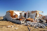
The tornado destroyed businesses and residences across a swath over 0.5 mi (0.80467 km) wide and 35 mi (56.3 km) long. In Lone Grove alone, buildings were thrown off their slabs and the local chamber of commerce office was flattened. The tornado destroyed a furniture store, and shattered the glass lobby of the local UPS
United Parcel Service
United Parcel Service, Inc. , typically referred to by the acronym UPS, is a package delivery company. Headquartered in Sandy Springs, Georgia, United States, UPS delivers more than 15 million packages a day to 6.1 million customers in more than 220 countries and territories around the...
building. The destruction of a mobile home park containing 40 homes left close to 100 people homeless. One mobile home was thrown 100 yd (91.4 m) from its foundation. A total of 114 residences were destroyed in Lone Grove.
To the east of Lone Grove, the area north of Ardmore
Ardmore, Oklahoma
Ardmore is a business, cultural and tourism city in and the county seat of Carter County, Oklahoma, United States. As of the 2010 Census, the city had a population of 24,283, while a 2007 estimate has the Ardmore micropolitan statistical area totaling 56,694 residents...
was also hard hit. Several buildings, including those of the Beaver Academy and the Ardmore Adventist Academy, were destroyed. Although damage centered on the Ardmore Academy gymnasium, most of the campus was considered a total loss. In Ardmore, eight homes were destroyed and another 20 sustained damage.
Eight people were confirmed dead as a result of the tornado. Seven of these fatalities were in the town of Lone Grove; most were determined to have been caused by “blunt-force trauma to the head". Three of the victims were found inside their homes and two were found outside. A victim found in an open field was reportedly picked up and thrown by the tornado, and died on impact with the ground. One victim was crushed when a pickup truck fell on him; similarly, a truck driver died after being pinned under his vehicle on Interstate 35
Interstate 35
Interstate 35 is a north–south Interstate Highway in the central United States. I-35 stretches from Laredo, Texas, on the U.S.-Mexico border to Duluth, Minnesota, at Minnesota Highway 61 and 26th Avenue East. Many interstates used to have splits or spurs indicated with suffixed letters , but I-35...
. Two other victims, the parents of a 13-year old girl, were killed when the tornado picked the three of them out of their home and threw them 400 ft (121.9 m). Three people were rescued after being trapped in the ruins of their home for almost a day. Officials stated that 10 to 15 people remained unaccounted for on the night of February 12 but they were presumed to have left the area. An additional 46 people were injured. Total monetary damages from the tornado were estimated at $3 million.
Non-tornadic events
During the evening of February 10, a long line of severe thunderstorms developed along the tail-end of a cold frontCold front
A cold front is defined as the leading edge of a cooler mass of air, replacing a warmer mass of air.-Development of cold front:The cooler and denser air wedges under the less-dense warmer air, lifting it...
in central Texas. Meteorologists predicted embedded supercell thunderstorms that could produce hail up to 2.5 inches (6.4 cm) in diameter and wind gusts up to 90 mph (144.8 km/h). North of the squall line, bow echo
Bow echo
A bow echo is a term describing the characteristic radar return from a mesoscale convective system that is shaped like an archer’s bow. These systems can produce severe straight-line winds and occasionally tornadoes, causing major damage.-Research:...
thunderstorms developed in Missouri, causing widespread wind damage. By the morning of February 11, the squall line reached as far southeast as eastern Louisiana, where winds were recorded in excess of 70 mph (112.7 km/h) along with hail up to 1 inches (2.5 cm) in diameter. Around 12 pm EST (17:00 UTC), the first line of thunderstorms significantly weakened, but a new, narrow line developed in eastern Kentucky and Tennessee. A strong, deep layer wind field prevented a number of tornadoes from forming but instead caused widespread wind damage. Throughout the day, the line of low-topped thunderstorms continued eastward, reaching Ohio and West Virginia by 4 pm EST (21:00 UTC). Several hours later, the line broke apart, with the strongest storms tracking through Pennsylvania. By February 12, rain showers, accompanied by high winds up to 60 mph (96.6 km/h), affected most of the Northeastern United States.
| State | Power outages | Source |
|---|---|---|
| Alabama Alabama Alabama is a state located in the southeastern region of the United States. It is bordered by Tennessee to the north, Georgia to the east, Florida and the Gulf of Mexico to the south, and Mississippi to the west. Alabama ranks 30th in total land area and ranks second in the size of its inland... |
2,380+ | |
| Arkansas Arkansas Arkansas is a state located in the southern region of the United States. Its name is an Algonquian name of the Quapaw Indians. Arkansas shares borders with six states , and its eastern border is largely defined by the Mississippi River... |
315,324 | |
| Connecticut Connecticut Connecticut is a state in the New England region of the northeastern United States. It is bordered by Rhode Island to the east, Massachusetts to the north, and the state of New York to the west and the south .Connecticut is named for the Connecticut River, the major U.S. river that approximately... |
8,486 | |
| Delaware Delaware Delaware is a U.S. state located on the Atlantic Coast in the Mid-Atlantic region of the United States. It is bordered to the south and west by Maryland, and to the north by Pennsylvania... |
4,600 | |
| Illinois Illinois Illinois is the fifth-most populous state of the United States of America, and is often noted for being a microcosm of the entire country. With Chicago in the northeast, small industrial cities and great agricultural productivity in central and northern Illinois, and natural resources like coal,... |
14,590 | |
| Indiana Indiana Indiana is a US state, admitted to the United States as the 19th on December 11, 1816. It is located in the Midwestern United States and Great Lakes Region. With 6,483,802 residents, the state is ranked 15th in population and 16th in population density. Indiana is ranked 38th in land area and is... |
70,695 | |
| Kentucky Kentucky The Commonwealth of Kentucky is a state located in the East Central United States of America. As classified by the United States Census Bureau, Kentucky is a Southern state, more specifically in the East South Central region. Kentucky is one of four U.S. states constituted as a commonwealth... |
161,588 | |
| Louisiana Louisiana Louisiana is a state located in the southern region of the United States of America. Its capital is Baton Rouge and largest city is New Orleans. Louisiana is the only state in the U.S. with political subdivisions termed parishes, which are local governments equivalent to counties... |
12,000 | |
| Massachusetts Massachusetts The Commonwealth of Massachusetts is a state in the New England region of the northeastern United States of America. It is bordered by Rhode Island and Connecticut to the south, New York to the west, and Vermont and New Hampshire to the north; at its east lies the Atlantic Ocean. As of the 2010... |
360+ | |
| Maryland Maryland Maryland is a U.S. state located in the Mid Atlantic region of the United States, bordering Virginia, West Virginia, and the District of Columbia to its south and west; Pennsylvania to its north; and Delaware to its east... |
50,820 | |
| Michigan Michigan Michigan is a U.S. state located in the Great Lakes Region of the United States of America. The name Michigan is the French form of the Ojibwa word mishigamaa, meaning "large water" or "large lake".... |
57,000 | |
| Missouri Missouri Missouri is a US state located in the Midwestern United States, bordered by Iowa, Illinois, Kentucky, Tennessee, Arkansas, Oklahoma, Kansas and Nebraska. With a 2010 population of 5,988,927, Missouri is the 18th most populous state in the nation and the fifth most populous in the Midwest. It... |
7,629 | |
| New Jersey New Jersey New Jersey is a state in the Northeastern and Middle Atlantic regions of the United States. , its population was 8,791,894. It is bordered on the north and east by the state of New York, on the southeast and south by the Atlantic Ocean, on the west by Pennsylvania and on the southwest by Delaware... |
93,816 | |
| New York New York New York is a state in the Northeastern region of the United States. It is the nation's third most populous state. New York is bordered by New Jersey and Pennsylvania to the south, and by Connecticut, Massachusetts and Vermont to the east... |
84,624 | |
| Ohio Ohio Ohio is a Midwestern state in the United States. The 34th largest state by area in the U.S.,it is the 7th‑most populous with over 11.5 million residents, containing several major American cities and seven metropolitan areas with populations of 500,000 or more.The state's capital is Columbus... |
585,775 | |
| Oklahoma Oklahoma Oklahoma is a state located in the South Central region of the United States of America. With an estimated 3,751,351 residents as of the 2010 census and a land area of 68,667 square miles , Oklahoma is the 28th most populous and 20th-largest state... |
61,000 | |
| Pennsylvania Pennsylvania The Commonwealth of Pennsylvania is a U.S. state that is located in the Northeastern and Mid-Atlantic regions of the United States. The state borders Delaware and Maryland to the south, West Virginia to the southwest, Ohio to the west, New York and Ontario, Canada, to the north, and New Jersey to... |
400,000+ | |
| Tennessee Tennessee Tennessee is a U.S. state located in the Southeastern United States. It has a population of 6,346,105, making it the nation's 17th-largest state by population, and covers , making it the 36th-largest by total land area... |
74,052 | |
| Texas Texas Texas is the second largest U.S. state by both area and population, and the largest state by area in the contiguous United States.The name, based on the Caddo word "Tejas" meaning "friends" or "allies", was applied by the Spanish to the Caddo themselves and to the region of their settlement in... |
15,000 | |
| Virginia Virginia The Commonwealth of Virginia , is a U.S. state on the Atlantic Coast of the Southern United States. Virginia is nicknamed the "Old Dominion" and sometimes the "Mother of Presidents" after the eight U.S. presidents born there... |
28,059 | |
| West Virginia West Virginia West Virginia is a state in the Appalachian and Southeastern regions of the United States, bordered by Virginia to the southeast, Kentucky to the southwest, Ohio to the northwest, Pennsylvania to the northeast and Maryland to the east... |
225,000 | |
| Total | 2,272,798+ | |
Oklahoma
In addition to the strong tornadoes, Oklahoma was affected by high winds and large hail. The hail, measuring up to 4.5 inches (11.4 cm) in diameter, caused significant damage in Okesa. Numerous cars were hit and several houses sustained roof damage; the cost of the hail damage was estimated at $100,000 in the town. Heavy rains produced by the storms also caused isolated flooding, inundating numerous streets with several feet of water. LightningLightning
Lightning is an atmospheric electrostatic discharge accompanied by thunder, which typically occurs during thunderstorms, and sometimes during volcanic eruptions or dust storms...
also produced damage in the state, with one bolt striking an oil tank, igniting a fire. The fire severely damaged the tank, leaving $13,000 in damages. Throughout the state, an estimated 61,000 people lost power: 29,000 lost power due to thunderstorms and 32,000 due to tornadoes. In Mississippi, strong winds on the backside of the cold front blew a metal roof off a power company building, bringing down several trees and power lines. Damages in the state amounted to $35,000.
Texas
Strong straight-line winds near 70 mph (112.7 km/h) caused significant damage in Hamilton County, Texas. A barn sustained severe damage and a home lost most of its roof. 80 mph (128.7 km/h) wind destroyed a small outbuilding and carried debris about 1.5 mi (2.4 km) north. A trailer near Hamilton Municipal AirportHamilton Municipal Airport (Texas)
Hamilton Municipal Airport is a city-owned public-use airport located two miles south of the central business district of Hamilton, a city in Hamilton County, Texas, United States.Although most U.S...
was broken off its moorings and moved 20 ft (6.1 m). Several mobile homes near Hamilton
Hamilton, Texas
Hamilton is a city in Hamilton County in Central Texas. The population was 3,095 at the 2010 census. It is the county seat of Hamilton County.-Geography:Hamilton is located at ....
sustained damage after tree limbs fell on them. In Huron, several outbuildings were damaged or destroyed and a permanent building was damaged at a youth retreat center. An estimated 15,000 residences were without power following the storms in Texas. One home in McGregor
McGregor, Texas
McGregor is a city in Coryell and McLennan Counties in the U.S. state of Texas. The population was 4,727 at the 2000 census.McGregor lies in two counties as well as two metropolitan areas...
was destroyed by the winds. The three people who lived in the home, one of whom was a child, all sustained injuries. The father had a few broken ribs and several scratches, injuries sustained during a search for his son. In Louisiana, 12,000 residences lost power due to the storm system. Two wildfires were sparked in Kenedy County and Kleberg County, burning 300 and 20 acre (121.4 and 8.1 ) respectively. The larger of the two fires was along Texas State Highway 77. The second fire burned three homes and threatened 20 others.
Arkansas
In Arkansas, high winds produced by the squall line knocked out power to 315,324 residences and caused widespread structural damage. Trees and power lines were brought down in eight counties, and several homes in Independence and Van Buren County sustained damage. The damage in these counties was caused by winds gusting up to 57 mph (91.7 km/h) and leaving $200,000 in damages. An 80 mph (128.7 km/h) wind gust in Van Buren blew a barn onto Arkansas Highway 9Arkansas Highway 9
Arkansas Highway 9 is a designation for two state highways in east Arkansas. The northern segment of runs from AR 5 to U.S. Route 63 in Mammoth Spring. A southern segment of begins at U.S. Route 79 at Eagle Mills and heads north to U.S. Route 67 in Malvern before terminating.-Crows to Mammoth...
. Hundreds of trees were blown down, many of which fell on homes, causing widespread damage which amounted to approximately $625,000. In Conway County, a sawmill and two barns were destroyed, while several homes and a church also sustained damage, mainly roof damage. Damages in the county were estimated at $300,000. Numerous homes sustained wind damage and two mobile homes and a recreational vehicle were overturned. Damages in the county were estimated at $750,000. Total damages throughout the state were estimated at $2.4 million. Seven people sustained injuries in the state.
Ohio
In Ohio, 70 mph (112.7 km/h) wind gusts led to a highway accident that killed a truck driver. The high winds also caused significant damage throughout the state. Heavy rains produced by the same system inundated several streets in flood-prone towns in Ohio. In Scioto CountyScioto County, Ohio
As of the census of 2000, there were 79,195 people, 30,871 households, and 21,362 families residing in the county. The population density was 129 people per square mile . There were 34,054 housing units at an average density of 56 per square mile...
, a the high winds destroyed a brick house and brought down power lines. The most significant damage resulted from the strong pressure gradient behind the frontal system. Thousands of tree were knocked down or uprooted by winds gusting in excess of 75 mph (120.7 km/h), cutting power to 585,775 residences. Ten railroad cars were knocked off their tracks near Shelby
Shelby, Ohio
Shelby is a city in Richland County in the U.S. state of Ohio, northwest of the city of Mansfield. It is part of the Mansfield, Ohio Metropolitan Statistical Area. The population was 9,821 at the 2000 census.-History:...
. Several hundred homes lost shingles and gutters due to the winds. Wind also overturned two semi-trailers
Semi-trailer truck
A semi-trailer truck, also known as a semi, tractor-trailer, or articulated truck or articulated lorry, is an articulated vehicle consisting of a towing engine , and a semi-trailer A semi-trailer truck, also known as a semi, tractor-trailer, or (in the United Kingdom and Ireland) articulated truck...
, though the drivers of both vehicles were unharmed. A vacant school building in Epworth lost its entire roof. Some windows were damaged or broken by flying debris or fallen trees. Power outages forced numerous schools to close for at least two days following the storm. A large barn was leveled just north of Brighton
Brighton Township, Lorain County, Ohio
Brighton Township is one of the eighteen townships of Lorain County, Ohio, United States. The 2000 census found 942 people in the township.-Geography:Located in southwestern Lorain County, it borders the following townships:*Camden Township - north...
in Lorain County by 64 mph (103 km/h) winds. Throughout the state, damages from the storm system amounted to $4.7 million.
Missouri, Kentucky, Tennessee and Michigan
In Missouri, high winds caused widespread damage and knocked out power to 7,629 residences. Several homes and businesses lost their windows due to 65 mph (104.6 km/h) wind gusts produced within squall lines. In Huntsville, AlabamaHuntsville, Alabama
Huntsville is a city located primarily in Madison County in the central part of the far northern region of the U.S. state of Alabama. Huntsville is the county seat of Madison County. The city extends west into neighboring Limestone County. Huntsville's population was 180,105 as of the 2010 Census....
, a car carrying four people lost control on rain-slicked roads and crashed into a van, killing one of the occupants and injuring the other three. Another fatality occurred in Kentucky when a utility worker was knocked over by high winds and fell 30 ft (9.1 m) to his death while trying to restore power. Following the widespread power outages from a severe ice storm
January 2009 Central Plains and Midwest ice storm
The January 2009 ice storm was a major ice storm that occurred over parts of Oklahoma, Arkansas, Missouri, Illinois, Indiana, West Virginia, and Kentucky. The storm produced widespread power outages for over 2 million people due to heavy ice accumulation...
, an additional 161,588 residences lost power due to 60 mph (96.6 km/h) winds. Flooding and high winds in Michigan knocked out power to about 57,000 residences. In southern Michigan, upwards of 0.8 inches (2 cm) of rain fell, leading to faster snowmelt. In Tennessee, several structures were damaged and numerous trees were knocked down, closing roads throughout the state as the squall line tracked eastward. A total of 74,052 residences lost power due to the winds. Winds gusting up to 85 mph (136.8 km/h) caused substantial damage in Rutherford County
Rutherford County, Tennessee
Rutherford County is a county located in the U.S. state of Tennessee. As of the 2010 census, it is the state's fifth-largest county by population with 262,604 people, an increase of 44.3 percent over the 2000 population of 182,023. Its county seat is Murfreesboro, which is also the geographic...
. Several commercial buildings had major roof damage, leaving $150,000 in damages. Throughout Tennessee, damages from the storm system were estimated at $1.1 million.
Iowa, Indiana and Virginia
In Iowa, heavy rains triggered rapid snowmelt, causing isolated flooding. Only minor impacts resulted from the flooding and total damages from the event was estimated at $25,000. A total of 14,590 residences lost power in Indiana. Several large trees were brought down by high winds, one of which fell on a home in South BendSouth Bend, Indiana
The city of South Bend is the county seat of St. Joseph County, Indiana, United States, on the St. Joseph River near its southernmost bend, from which it derives its name. As of the 2010 Census, the city had a total of 101,168 residents; its Metropolitan Statistical Area had a population of 316,663...
, leaving $50,000 in damages. In the town of Carmel
Carmel, Indiana
Carmel is a city in Hamilton County, Indiana, United States located immediately north of Indianapolis, Indiana. The population was 79,191 at the 2010 census, and is one of the most affluent communities in the Midwest....
, a total of 2.75 inches (69.9 mm) of rain fell, the highest in the state. The heavy rains, in combination with unseasonably warm temperatures, led to significant snowmelt and flooding. The highest wind gust recorded in the state was 80 mph (128.7 km/h) in Crawford County
Crawford County, Indiana
Crawford County is a county located in the U.S. state of Indiana. As of 2010, the population was 10,713. The county seat is English.-Geography:...
. A total of 70,695 residences lost power in Illinois. Rainfall up to 4 inches (101.6 mm) fell throughout most of the state. Several major roadways were covered in flood waters. The Little Wabash River
Little Wabash River
The Little Wabash River is a tributary of the Wabash River in east-central and southeastern Illinois in the United States. Via the Wabash and Ohio rivers, it is part of the watershed of the Mississippi River.-Course:...
overflowed its banks and inundated nearby roads. Along Illinois Route 1
Illinois Route 1
Illinois Route 1 is a state highway in the U.S. state of Illinois. Running parallel to the Indiana border, it is also the longest state road, starting on the south side of Chicago as Halsted Street at the intersection with 95th Street, south to a free ferry crossing to Kentucky at Cave-In-Rock on...
, a large tree blocked a section of the road near Georgetown
Georgetown, Illinois
Georgetown is a city in Vermilion County, Illinois, United States. It is part of the 'Danville, Illinois Metropolitan Statistical Area'. The population was 3,628 at the 2000 census, and 3,412 as of an estimate in 2009.-History:...
. The fallen tree resulted in a vehicle accident but the driver was unharmed. One person was killed by high winds in Davy, West Virginia
Davy, West Virginia
Davy is a town in McDowell County, West Virginia, USA. The population was 373 at the 2000 census. Davy was incorporated in 1948. It is a mostly residential community in a coal mining district along the main line of the Norfolk Southern Railway.-Geography:...
when a gymnasium roof collapsed. Throughout the state, power was knocked out to an estimated 225,000 residences. In Montgomery County, Virginia
Montgomery County, Virginia
As of the census of 2000, there were 83,629 people, 30,997 households, and 17,203 families residing in the county. The population density was 215 people per square mile . There were 32,527 housing units at an average density of 84 per square mile...
, winds knocked down power lines which sparked two brush fires, one of which burned a total of 12 acres (4.9 ha). Winds up to 65 mph (104.6 km/h) cut power to 28,059 residences in the state. The strong winds also cut power to 50,820 residences in Maryland.
Western Pennsylvania and Chesapeake watershed
Hurricane-forceTropical cyclone
A tropical cyclone is a storm system characterized by a large low-pressure center and numerous thunderstorms that produce strong winds and heavy rain. Tropical cyclones strengthen when water evaporated from the ocean is released as the saturated air rises, resulting in condensation of water vapor...
wind gusts up to 92 mph (148.1 km/h) caused significant damage and power losses in Pennsylvania. Throughout the state, at least 400,000 residences lost power due to the winds. Allegheny Power stated that the loss of power due to this system was the largest ever experienced by the company. Thousands of trees and power lines were brought down by strong winds and numerous homes sustained significant damage. Although most of the damage to homes consisted of shingle damage, several homes lost gutters and had portions of their siding blown off.
In Pottstown
Pottstown, Pennsylvania
Pottstown is a borough in Montgomery County, Pennsylvania, United States northwest of Philadelphia and southeast of Reading, on the Schuylkill River. Pottstown was laid out in 1752–53 and named Pottsgrove in honor of its founder, John Potts. The old name was abandoned at the time of the...
, a large portion of the roof of a four-story building was blown off, forcing residents to evacuate the building. An 18 ft (5.5 m) pillar was knocked down at the First Moravian Church in Easton
Easton, Pennsylvania
Easton is a city in Northampton County, Pennsylvania, United States. The population was 26,800 as of the 2010 census. It is the county seat of Northampton County....
. In Northampton County
Northampton County, Pennsylvania
As of the 2010 census, the county was 86.3% White, 5.0% Black or African American, 0.2% Native American or Alaskan Native, 2.4% Asian, 0.0% Native Hawaiian, 2.2% were two or more races, and 3.8% were some other race. 10.5% of the population were of Hispanic or Latino ancestry.As of the census of...
, a fire sparked by fallen power lines destroyed a barn and partially melted a nearby metal shed. The blaze was fully contained by 40 firefighters. Another fire sparked by fallen power lines destroyed a garage in Lower Merion Township
Lower Merion Township, Pennsylvania
Lower Merion Township is a township in Montgomery County, Pennsylvania and part of the Pennsylvania Main Line. As of the 2010 census, the township had a total population of 57,825...
. In Philadelphia, the roof of a portable classroom began to peel off, forcing the forty students inside to evacuate to a safer structure. A large tree fell through one house and severely damaged the roof of a nearby home. Numerous major highways and local streets were shut down for several hours to allow cleanup crews to clear debris. Throughout the state, damages from the storm system amounted to $3.7 million.
New York
In upstate New York, winds in excess of 50 mph (80.5 km/h) shattered windows, toppled numerous trees, and brought down power lines, cutting power to more than 50,000 residences. Unseasonably warm temperatures and heavy rains from the storm system increased the snowmelt rate in northern areas of the state. In Genesee CountyGenesee County, New York
Genesee County is a county located in Western New York, United States. As of the 2010 census, the population was 60,079. Its name is from the Seneca Indian word Gen-nis'-hee-yo meaning "The Beautiful Valley." Its county seat is Batavia.- History :...
, an estimated 2 to 5 in (5.1 to 12.7 cm) of the snowpack melted, triggering flash floods along several rivers. The Tonawanda Creek
Tonawanda Creek
Tonawanda Creek is a small river in Western New York, in the United States. William Bright says the best that can be said of the name is that it is "probably from an Iroquoian source, but of unclear derivation".-Description:...
reached a height of 14.38 ft (4.4 m), 2.38 ft (0.725424 m) above flood stage. Several homes were inundated by flood waters throughout the region. In all, 84,624 residences lost power in New York State. The storm system continued producing gusty winds through February 12, which caused tree damage and power outages, and killed a construction worker in the New York City metropolitan area. The construction worker was killed after a cinder block wall collapsed due to high-winds. Winds in the city gusted to 65 mph (104.6 km/h) in the Bronx. Throughout Long Island, an estimated 4,000 people lost power.
New Jersey, Connecticut and Massachusetts
In New Jersey, strong winds gusted up to 55 mph (88.5 km/h), bringing down tree limbs that killed two people. A total of 93,816 residences were also left without power at the height of the storm. High winds on the backside of the storm brought down a power line that sparked a small fire in Galloway TownshipGalloway Township, New Jersey
Galloway Township is a township in Atlantic County, New Jersey, United States. As of the 2010 United States Census, the township population was 37,349...
, burning a total of 40 acres (16.2 ha). A total of 8,486 Connecticut residences were left without power and one boy was injured after high winds damaged numerous power lines and tree limbs. In Massachusetts, gusts up to 55 mph (88.5 km/h) brought down several trees and cut power to residences in Middleborough
Middleborough, Massachusetts
Middleborough is a town in Plymouth County, Massachusetts, United States. The population was 21,117 as of 2008.For geographic and demographic information on the village of Middleborough Center, please see the article Middleborough Center, Massachusetts....
, Boston, Brookline
Brookline, Massachusetts
Brookline is a town in Norfolk County, Massachusetts, United States, which borders on the cities of Boston and Newton. As of the 2010 census, the population of the town was 58,732.-Etymology:...
and Hingham
Hingham, Massachusetts
Hingham is a town in northern Plymouth County on the South Shore of the U.S. state of Massachusetts and suburb in Greater Boston. The United States Census Bureau 2008 estimated population was 22,561...
. The Western Massachusetts Electric Company
Northeast Utilities
Northeast Utilities is a publicly-traded, Fortune 500 energy company headquartered in Berlin, Connecticut, with several regulated subsidiaries offering retail electricity and natural gas service to more than 2.1 million customers in New England....
reported that at least 360 residences lost power during the storm. Moderate snow fell across portions of The Berkshires
The Berkshires
The Berkshires , is a highland geologic region located in the western parts of Massachusetts and Connecticut.Also referred to as the Berkshire Hills, Berkshire Mountains, and Berkshire Plateau, the region enjoys a vibrant tourism industry based on music, arts, and recreation.-Definition:The term...
late on February 12 as the storm system began entering the Atlantic Ocean
Atlantic Ocean
The Atlantic Ocean is the second-largest of the world's oceanic divisions. With a total area of about , it covers approximately 20% of the Earth's surface and about 26% of its water surface area...
, while isolated areas received upwards of 6 inches (15.2 cm).
Aftermath
In the wake of the tornado outbreak law enforcement officers, including 30 national guard troops, were sent to Lone Grove to provide security. The American Red CrossAmerican Red Cross
The American Red Cross , also known as the American National Red Cross, is a volunteer-led, humanitarian organization that provides emergency assistance, disaster relief and education inside the United States. It is the designated U.S...
opened shelters in Ardmore, Edmond, and Oklahoma City. About 100 volunteers from the Sorghum Mill Estates Neighborhood Association traveled to affected areas in Edmond to help with cleanup efforts. A local restaurant provided free meals to the volunteers as they assisted relief workers. The Salvation Army
Salvation Army
The Salvation Army is a Protestant Christian church known for its thrift stores and charity work. It is an international movement that currently works in over a hundred countries....
had two canteens in Oklahoma City, one in Lone Grove, and one in Perkins
Perkins, Oklahoma
Perkins is a city in Payne County, Oklahoma, United States. The population was 2,272 at the 2000 census. The name is derived from Walden Perkins, a congressman who helped establish the local post office. The Iowa Tribe of Oklahoma is headquartered here....
. About 2,000 meals, drinks, and snacks were provided by the Salvation Army to emergency responders. Feed the Children
Feed The Children
Feed The Children founded in 1979 is an international, non-profit relief organization guided by Christian values, whose stated mission is "providing hope and resources for those without life's essentials". In FY 2010, Feed The Children distributed more than 133 million pounds of food and other...
sent two truckloads of relief supplies to Carter County
Carter County, Oklahoma
Carter County is a county located in the U.S. state of Oklahoma. As of 2010, the population was 47,557. Its county seat is Ardmore.Carter County is part of the Ardmore, Oklahoma, Micropolitan Statistical Area.-Geography:According to the U.S...
. They also sent three food trucks, containing a total of 619 meals, 900 drinks, and about 500 snacks, to Ardmore. On February 22, the New Life Baptist Church sent drinks and prepackaged snacks, along with items needed for clean-up. Baptist Disaster Relief assisted in Lone Grove with food and emotional care. The Oklahoma City Thunder
Oklahoma City Thunder
The Oklahoma City Thunder are a professional basketball franchise based in Oklahoma City, Oklahoma. They play in the Northwest Division of the Western Conference in the National Basketball Association ; their home court is at Chesapeake Energy Arena....
of the National Basketball Association
National Basketball Association
The National Basketball Association is the pre-eminent men's professional basketball league in North America. It consists of thirty franchised member clubs, of which twenty-nine are located in the United States and one in Canada...
(NBA) gave away two tickets to anyone who made a donation of $25 or an equivalent amount of food to benefit victims of the tornado. A concert featuring Chris Cagle
Chris Cagle
Chris Cagle is an American country music artist. Signed with Virgin Records Nashville in 2000, Cagle made his debut on the Billboard Hot Country Singles & Tracks charts with the single "My Love Goes On and On", the first single from his debut album Play It Loud...
and other local musicians at Heritage Hall in Ardmore raised over $18,000 to benefit Carter County tornado victims. Another concert set up by the Salvation Army raised $2,300 more for victims.
The Governor of Oklahoma Brad Henry
Brad Henry
Charles Bradford "Brad" Henry was the 26th Governor of the U.S. state of Oklahoma. A member of the Democratic Party, he was elected governor in 2002...
declared a State of Emergency
State of emergency
A state of emergency is a governmental declaration that may suspend some normal functions of the executive, legislative and judicial powers, alert citizens to change their normal behaviours, or order government agencies to implement emergency preparedness plans. It can also be used as a rationale...
in 17 counties and described the outbreak as the worst natural disaster he had seen since becoming governor. On February 15, President Obama approved Henry's request for federal assistance in Carter, Logan and Oklahoma counties. A disaster recovery center was set up by the Federal Emergency Management Agency
Federal Emergency Management Agency
The Federal Emergency Management Agency is an agency of the United States Department of Homeland Security, initially created by Presidential Reorganization Plan No. 1 of 1978 and implemented by two Executive Orders...
(FEMA) on February 20. Homeowners were allowed to borrow $200,000 to repair damages to their home or find a temporary or permanent shelter. They were also allowed to borrow up to $40,000 to replace lost property. Businesses were allowed to borrow up to $2 million for damage repair, property loss, and economic loss. By February 23, about $781,000 had been given in federal grants. On February 25, FEMA approved Governor Henry's request for public assistance in Carter, Coal
Coal County, Oklahoma
Coal County is a county located in the U.S. state of Oklahoma. As of 2000, the population is 6,031. Its county seat is Coalgate.-Geography:According to the U.S. Census Bureau, the county has a total area of , of which is land and is water....
and Love counties. The estimated cost to clear the 7,000 tons of debris in Lone Grove was placed at $500,000, of which $90,000 has been paid for by FEMA. The Department of Homeland Security
United States Department of Homeland Security
The United States Department of Homeland Security is a cabinet department of the United States federal government, created in response to the September 11 attacks, and with the primary responsibilities of protecting the territory of the United States and protectorates from and responding to...
offered to assist with the reconstruction of homes and businesses and to support those who were left homeless. President Barack Obama
Barack Obama
Barack Hussein Obama II is the 44th and current President of the United States. He is the first African American to hold the office. Obama previously served as a United States Senator from Illinois, from January 2005 until he resigned following his victory in the 2008 presidential election.Born in...
passed along his condolences and best wishes to the victims of the tornado.