

Cold-core low
Encyclopedia
A cold-core low, also known as a cold low or cold-core cyclone, is a cyclone
aloft which has an associated cold pool of air residing at high altitude within the Earth's troposphere
. It is a low pressure system which strengthens with height in accordance with the thermal wind
relationship. These systems can be referred to as upper level lows. If a weak surface circulation forms in response to such a feature at subtropical latitudes of the eastern north Pacific
or north Indian ocean
s, it is called a subtropical cyclone
. Cloud cover and rainfall mainly occurs with these systems during the day. Severe weather
, such as tornado
es, can occur near the center of cold-core lows. Cold lows can help spawn cyclone
s with significant weather
impacts, such as polar low
s, lows that form along the east side of continents, and tropical cyclone
s. In regards to tropical cyclones, cold lows can lead directly to their development due to their associated cold pool of air aloft or by acting as additional outflow
channels to aid in further development.
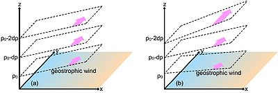 Cold cyclones are stronger aloft than at the Earth's surface, or stronger in areas of the troposphere with lower pressures, per the thermal wind relationship and the hypsometric equation
. The hypsometric equation dictates that colder atmospheres have less room between pressure surfaces, which corresponds to the concept of lower atmospheric thickness, and the thermal wind relation indicates that in this situation, the wind increases with height. It also means that an isolated pool of cold air aloft is associated with the feature. Because of its cold center, the center shows an area of thickness minimum. Since the temperature at any given radius is similar and parallel to the orientation of the pressure gradient, and therefore the wind
, it is barotropic
in nature. The movement of cold-core cyclones can be erratic since they are separated from the main belt of the Westerlies
, which would otherwise steer them progressively to the east.
Most cloud
cover and precipitation
in association with cold lows occurs during the daylight hours as sunlight warms the Earth's surface, destabilizing the atmosphere and causing upward vertical motion. The development of severe weather, particularly tornadoes, can occur near the center of these systems over land during any season of the year. During winter, when cold-core lows with temperatures in the mid-levels of the troposphere reach -45 C move over open waters, deep convection forms which allows polar low
development to become possible.
Kona lows, most extratropical cyclone
s, and tropical upper tropospheric cyclones
are cold core lows. In the eastern half of the north Pacific ocean and north Indian ocean, the formation of a weak circulation underneath a mid to upper-tropospheric low
which has cut off from the main belt of the westerlies during the cold season (winter
) is called a subtropical cyclone. In the case of the north Indian ocean, the formation of this type of vortex leads to the onset of monsoon
rains during the wet season
.
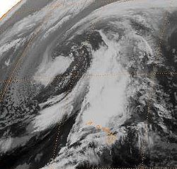
East coast lows form near and east of where a cold core low interacts with a sea surface temperature
(SST) gradient along the east coast of continent
s, such as Asia
, North America
, southern Africa
, and Australia
within a pre-existing area of high pressure. Those offshore the East Coast of the United States
, which normally form in the months between October and April, are termed nor'easter
s. Not initially associated with weather fronts, they form in tandem with blocking anticyclone
s at higher latitudes, which leads to a slow poleward movement up the SST gradient. East coast lows can persist for up to a week. Some East coast lows develop rapidly, becoming meteorological bombs
. There is a 4.5 year cycle in the formation of East coast lows near Australia, in years in transition between warm (El Niño) and cold (La Niña) ENSO
years. These systems can develop strong wind, heavy rains, waves over 10 metres (32.8 ft) in height, and eye
features on weather satellite
imagery.
 The summer tropical upper tropospheric trough in the Southern Hemisphere
lies over the trade wind
region of the east central Pacific and can cause tropical cyclogenesis
offshore Central America
. In the western Pacific, tropical upper tropospheric low
s are the main cause for the few tropical cyclones which develop north of the 20th parallel north
and east of the 160th meridian east
during La Niña events.
Trailing upper cyclones and upper troughs can cause additional outflow channels and aid in the intensification process of tropical cyclones. Developing tropical disturbances can help create or deepen upper troughs or upper lows in their wake due to the outflow jet stream
emanating from the developing tropical disturbance/cyclone. In the western North Pacific, there are strong reciprocal relationships between the areas of formative tropical cyclones and that of the lower tropospheric monsoon troughs and the tropical upper tropospheric trough
. Tropical cyclone movement can also be influenced by TUTT cells within 1700 kilometres (1,056.3 mi) of their position, which can lead to non-climatological tracks, such as eastward movement within the tropics or westward movement in an area where the Westerlies
normally dominate.
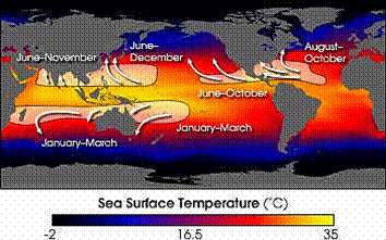
Normally, an ocean temperature of 26.5°C (79.7°F) spanning through a depth of at least 50 metres (164 ft) is one of the six requirements needed to maintain the special mesocyclone
that is the tropical cyclone. Cooler air temperatures at a higher altitude (e.g., at the 500 hPa
level, or 5.9 km) can lead to tropical cyclogenesis at lower water temperatures than normal, as a certain lapse rate
is required to force the atmosphere to be unstable enough for convection. In a moist atmosphere, this lapse rate is 6.5 °C/km (19 °F/mi), while in an atmosphere with less than 100% relative humidity
, the required lapse rate is 9.8 °C/km (29 °F/mi).
At the 500 hPa level, the air temperature averages -7 °C (18 °F) within the tropics, but air in the tropics is normally dry at this level, giving the air room to wet-bulb
, or cool as it moistens, to a more favorable temperature that can then support convection. A wetbulb temperature at 500 hPa in a tropical atmosphere of -13.2 C is required to initiate convection if the water temperature is 26.5 °C (79.7 °F), and this temperature requirement increases or decreases proportionally by 1 °C in the sea surface temperature for each 1 °C change at 500 hpa. Under a cold cyclone, 500 hPa temperatures can fall as low as -30 C, which can initiate convection even in the driest atmospheres. This also explains why moisture in the mid-levels of the troposphere
, roughly at the 500 hPa level, is normally a requirement for development. However, when dry air is found at the same height, temperatures at 500 hPa need to be even colder as dry atmospheres require a greater lapse rate for instability than moist atmospheres. At heights near the tropopause
, the 30-year average temperature (as measured in the period encompassing 1961 through 1990) was -77 °C (-132 °F). A recent example of a tropical cyclone
that maintained itself over cooler waters was Epsilon of the 2005 Atlantic hurricane season
.
Cyclone
In meteorology, a cyclone is an area of closed, circular fluid motion rotating in the same direction as the Earth. This is usually characterized by inward spiraling winds that rotate anticlockwise in the Northern Hemisphere and clockwise in the Southern Hemisphere of the Earth. Most large-scale...
aloft which has an associated cold pool of air residing at high altitude within the Earth's troposphere
Troposphere
The troposphere is the lowest portion of Earth's atmosphere. It contains approximately 80% of the atmosphere's mass and 99% of its water vapor and aerosols....
. It is a low pressure system which strengthens with height in accordance with the thermal wind
Thermal wind
The thermal wind is a vertical shear in the geostrophic wind caused by a horizontal temperature gradient. Its name is a misnomer, because the thermal wind is not actually a wind, but rather a wind shear.- Physical Intuition :...
relationship. These systems can be referred to as upper level lows. If a weak surface circulation forms in response to such a feature at subtropical latitudes of the eastern north Pacific
Pacific Ocean
The Pacific Ocean is the largest of the Earth's oceanic divisions. It extends from the Arctic in the north to the Southern Ocean in the south, bounded by Asia and Australia in the west, and the Americas in the east.At 165.2 million square kilometres in area, this largest division of the World...
or north Indian ocean
Indian Ocean
The Indian Ocean is the third largest of the world's oceanic divisions, covering approximately 20% of the water on the Earth's surface. It is bounded on the north by the Indian Subcontinent and Arabian Peninsula ; on the west by eastern Africa; on the east by Indochina, the Sunda Islands, and...
s, it is called a subtropical cyclone
Subtropical cyclone
A subtropical cyclone is a weather system that has some characteristics of a tropical and an extratropical cyclone. As early as the 1950s, meteorologists were unclear whether they should be characterized as tropical or extratropical cyclones. They were officially recognized by the National...
. Cloud cover and rainfall mainly occurs with these systems during the day. Severe weather
Severe weather
Severe weather phenomena are weather conditions that are hazardous to human life and property.- Examples Include :Severe weather can occur under a variety of situations, but three characteristics are generally needed: a temperature or moisture boundary, moisture, and , instability in the...
, such as tornado
Tornado
A tornado is a violent, dangerous, rotating column of air that is in contact with both the surface of the earth and a cumulonimbus cloud or, in rare cases, the base of a cumulus cloud. They are often referred to as a twister or a cyclone, although the word cyclone is used in meteorology in a wider...
es, can occur near the center of cold-core lows. Cold lows can help spawn cyclone
Cyclone
In meteorology, a cyclone is an area of closed, circular fluid motion rotating in the same direction as the Earth. This is usually characterized by inward spiraling winds that rotate anticlockwise in the Northern Hemisphere and clockwise in the Southern Hemisphere of the Earth. Most large-scale...
s with significant weather
Weather
Weather is the state of the atmosphere, to the degree that it is hot or cold, wet or dry, calm or stormy, clear or cloudy. Most weather phenomena occur in the troposphere, just below the stratosphere. Weather refers, generally, to day-to-day temperature and precipitation activity, whereas climate...
impacts, such as polar low
Polar low
A polar low is a small-scale, long-lived atmospheric low pressure system that is found over the ocean areas poleward of the main polar front in both the Northern and Southern Hemispheres. The systems usually have a horizontal length scale of less than and exist for no more than a couple of days. ...
s, lows that form along the east side of continents, and tropical cyclone
Tropical cyclone
A tropical cyclone is a storm system characterized by a large low-pressure center and numerous thunderstorms that produce strong winds and heavy rain. Tropical cyclones strengthen when water evaporated from the ocean is released as the saturated air rises, resulting in condensation of water vapor...
s. In regards to tropical cyclones, cold lows can lead directly to their development due to their associated cold pool of air aloft or by acting as additional outflow
Outflow (meteorology)
Outflow, in meteorology, is air that flows outwards from a storm system. It is associated with ridging, or anticyclonic flow. In the low levels of the troposphere, outflow radiates from thunderstorms in the form of a wedge of rain-cooled air, which is visible as a thin rope-like cloud on weather...
channels to aid in further development.
Characteristics
Hypsometric equation
The hypsometric equation relates an atmospheric pressure ratio to the equivalent thickness of an atmospheric layer under the assumptions of constant temperature and gravity...
. The hypsometric equation dictates that colder atmospheres have less room between pressure surfaces, which corresponds to the concept of lower atmospheric thickness, and the thermal wind relation indicates that in this situation, the wind increases with height. It also means that an isolated pool of cold air aloft is associated with the feature. Because of its cold center, the center shows an area of thickness minimum. Since the temperature at any given radius is similar and parallel to the orientation of the pressure gradient, and therefore the wind
Wind
Wind is the flow of gases on a large scale. On Earth, wind consists of the bulk movement of air. In outer space, solar wind is the movement of gases or charged particles from the sun through space, while planetary wind is the outgassing of light chemical elements from a planet's atmosphere into space...
, it is barotropic
Barotropic
In meteorology, a barotropic atmosphere is one in which the pressure depends only on the density and vice versa, so that isobaric surfaces are also isopycnic surfaces . The isobaric surfaces will also be isothermal surfaces, hence the geostrophic wind is independent of height...
in nature. The movement of cold-core cyclones can be erratic since they are separated from the main belt of the Westerlies
Westerlies
The Westerlies, anti-trades, or Prevailing Westerlies, are the prevailing winds in the middle latitudes between 30 and 60 degrees latitude, blowing from the high pressure area in the horse latitudes towards the poles. These prevailing winds blow from the west to the east, and steer extratropical...
, which would otherwise steer them progressively to the east.
Most cloud
Cloud
A cloud is a visible mass of liquid droplets or frozen crystals made of water and/or various chemicals suspended in the atmosphere above the surface of a planetary body. They are also known as aerosols. Clouds in Earth's atmosphere are studied in the cloud physics branch of meteorology...
cover and precipitation
Precipitation (meteorology)
In meteorology, precipitation In meteorology, precipitation In meteorology, precipitation (also known as one of the classes of hydrometeors, which are atmospheric water phenomena is any product of the condensation of atmospheric water vapor that falls under gravity. The main forms of precipitation...
in association with cold lows occurs during the daylight hours as sunlight warms the Earth's surface, destabilizing the atmosphere and causing upward vertical motion. The development of severe weather, particularly tornadoes, can occur near the center of these systems over land during any season of the year. During winter, when cold-core lows with temperatures in the mid-levels of the troposphere reach -45 C move over open waters, deep convection forms which allows polar low
Polar low
A polar low is a small-scale, long-lived atmospheric low pressure system that is found over the ocean areas poleward of the main polar front in both the Northern and Southern Hemispheres. The systems usually have a horizontal length scale of less than and exist for no more than a couple of days. ...
development to become possible.
Importance to cyclones within the subtropics and mid-latitudes
Kona lows, most extratropical cyclone
Extratropical cyclone
Extratropical cyclones, sometimes called mid-latitude cyclones or wave cyclones, are a group of cyclones defined as synoptic scale low pressure weather systems that occur in the middle latitudes of the Earth having neither tropical nor polar characteristics, and are connected with fronts and...
s, and tropical upper tropospheric cyclones
Upper tropospheric cyclonic vortex
An upper tropospheric cyclonic vortex is a vortex, or a circulation with a definable center, that usually moves slowly from east-northeast to west-southwest and is prevalent across Northern Hemisphere's warm season. Its circulations generally do not extend below in altitude, as it is an example...
are cold core lows. In the eastern half of the north Pacific ocean and north Indian ocean, the formation of a weak circulation underneath a mid to upper-tropospheric low
Upper tropospheric cyclonic vortex
An upper tropospheric cyclonic vortex is a vortex, or a circulation with a definable center, that usually moves slowly from east-northeast to west-southwest and is prevalent across Northern Hemisphere's warm season. Its circulations generally do not extend below in altitude, as it is an example...
which has cut off from the main belt of the westerlies during the cold season (winter
Winter
Winter is the coldest season of the year in temperate climates, between autumn and spring. At the winter solstice, the days are shortest and the nights are longest, with days lengthening as the season progresses after the solstice.-Meteorology:...
) is called a subtropical cyclone. In the case of the north Indian ocean, the formation of this type of vortex leads to the onset of monsoon
Monsoon
Monsoon is traditionally defined as a seasonal reversing wind accompanied by corresponding changes in precipitation, but is now used to describe seasonal changes in atmospheric circulation and precipitation associated with the asymmetric heating of land and sea...
rains during the wet season
Wet season
The the wet season, or rainy season, is the time of year, covering one or more months, when most of the average annual rainfall in a region occurs. The term green season is also sometimes used as a euphemism by tourist authorities. Areas with wet seasons are dispersed across portions of the...
.
East coast lows form near and east of where a cold core low interacts with a sea surface temperature
Sea surface temperature
Sea surface temperature is the water temperature close to the oceans surface. The exact meaning of surface varies according to the measurement method used, but it is between and below the sea surface. Air masses in the Earth's atmosphere are highly modified by sea surface temperatures within a...
(SST) gradient along the east coast of continent
Continent
A continent is one of several very large landmasses on Earth. They are generally identified by convention rather than any strict criteria, with seven regions commonly regarded as continents—they are : Asia, Africa, North America, South America, Antarctica, Europe, and Australia.Plate tectonics is...
s, such as Asia
Asia
Asia is the world's largest and most populous continent, located primarily in the eastern and northern hemispheres. It covers 8.7% of the Earth's total surface area and with approximately 3.879 billion people, it hosts 60% of the world's current human population...
, North America
North America
North America is a continent wholly within the Northern Hemisphere and almost wholly within the Western Hemisphere. It is also considered a northern subcontinent of the Americas...
, southern Africa
Africa
Africa is the world's second largest and second most populous continent, after Asia. At about 30.2 million km² including adjacent islands, it covers 6% of the Earth's total surface area and 20.4% of the total land area...
, and Australia
Australia
Australia , officially the Commonwealth of Australia, is a country in the Southern Hemisphere comprising the mainland of the Australian continent, the island of Tasmania, and numerous smaller islands in the Indian and Pacific Oceans. It is the world's sixth-largest country by total area...
within a pre-existing area of high pressure. Those offshore the East Coast of the United States
East Coast of the United States
The East Coast of the United States, also known as the Eastern Seaboard, refers to the easternmost coastal states in the United States, which touch the Atlantic Ocean and stretch up to Canada. The term includes the U.S...
, which normally form in the months between October and April, are termed nor'easter
Nor'easter
A nor'easter is a type of macro-scale storm along the East Coast of the United States and Atlantic Canada, so named because the storm travels to the northeast from the south and the winds come from the northeast, especially in the coastal areas of the Northeastern United States and Atlantic Canada...
s. Not initially associated with weather fronts, they form in tandem with blocking anticyclone
Anticyclone
An anticyclone is a weather phenomenon defined by the United States' National Weather Service's glossary as "[a] large-scale circulation of winds around a central region of high atmospheric pressure, clockwise in the Northern Hemisphere, counterclockwise in the Southern Hemisphere"...
s at higher latitudes, which leads to a slow poleward movement up the SST gradient. East coast lows can persist for up to a week. Some East coast lows develop rapidly, becoming meteorological bombs
Bomb (meteorology)
Bomb is a meteorological term for a baroclinic low pressure area characterized by a rapid pressure fall of at least 24 millibars in 24 hours. It is applied only to cold-air storms...
. There is a 4.5 year cycle in the formation of East coast lows near Australia, in years in transition between warm (El Niño) and cold (La Niña) ENSO
El Niño-Southern Oscillation
El Niño/La Niña-Southern Oscillation, or ENSO, is a quasiperiodic climate pattern that occurs across the tropical Pacific Ocean roughly every five years...
years. These systems can develop strong wind, heavy rains, waves over 10 metres (32.8 ft) in height, and eye
Eye (cyclone)
The eye is a region of mostly calm weather found at the center of strong tropical cyclones. The eye of a storm is a roughly circular area and typically 30–65 km in diameter. It is surrounded by the eyewall, a ring of towering thunderstorms where the second most severe weather of a cyclone...
features on weather satellite
Weather satellite
The weather satellite is a type of satellite that is primarily used to monitor the weather and climate of the Earth. Satellites can be either polar orbiting, seeing the same swath of the Earth every 12 hours, or geostationary, hovering over the same spot on Earth by orbiting over the equator while...
imagery.
Importance to tropical cyclones
Southern Hemisphere
The Southern Hemisphere is the part of Earth that lies south of the equator. The word hemisphere literally means 'half ball' or "half sphere"...
lies over the trade wind
Trade wind
The trade winds are the prevailing pattern of easterly surface winds found in the tropics, within the lower portion of the Earth's atmosphere, in the lower section of the troposphere near the Earth's equator...
region of the east central Pacific and can cause tropical cyclogenesis
Tropical cyclogenesis
Tropical cyclogenesis is the term that describes the development and strengthening of a tropical cyclone in the atmosphere. The mechanisms through which tropical cyclogenesis occurs are distinctly different from those through which mid-latitude cyclogenesis occurs...
offshore Central America
Central America
Central America is the central geographic region of the Americas. It is the southernmost, isthmian portion of the North American continent, which connects with South America on the southeast. When considered part of the unified continental model, it is considered a subcontinent...
. In the western Pacific, tropical upper tropospheric low
Upper tropospheric cyclonic vortex
An upper tropospheric cyclonic vortex is a vortex, or a circulation with a definable center, that usually moves slowly from east-northeast to west-southwest and is prevalent across Northern Hemisphere's warm season. Its circulations generally do not extend below in altitude, as it is an example...
s are the main cause for the few tropical cyclones which develop north of the 20th parallel north
20th parallel north
The 20th parallel north is a circle of latitude that is 20 degrees north of the Earth's equatorial plane. It crosses Africa, Asia, the Indian Ocean, the Pacific Ocean, North America, the Caribbean and the Atlantic Ocean....
and east of the 160th meridian east
160th meridian east
The meridian 160° east of Greenwich is a line of longitude that extends from the North Pole across the Arctic Ocean, Asia, the Pacific Ocean, the Southern Ocean, and Antarctica to the South Pole....
during La Niña events.
Trailing upper cyclones and upper troughs can cause additional outflow channels and aid in the intensification process of tropical cyclones. Developing tropical disturbances can help create or deepen upper troughs or upper lows in their wake due to the outflow jet stream
Jet stream
Jet streams are fast flowing, narrow air currents found in the atmospheres of some planets, including Earth. The main jet streams are located near the tropopause, the transition between the troposphere and the stratosphere . The major jet streams on Earth are westerly winds...
emanating from the developing tropical disturbance/cyclone. In the western North Pacific, there are strong reciprocal relationships between the areas of formative tropical cyclones and that of the lower tropospheric monsoon troughs and the tropical upper tropospheric trough
Tropical Upper Tropospheric Trough
A tropical upper tropospheric trough , also known as the mid-oceanic trough, is a trough situated in upper-level tropics. Its formation is usually caused by the intrusion of energy and wind from the mid-latitudes into the tropics. It can also develop from the inverted trough adjacent to an upper...
. Tropical cyclone movement can also be influenced by TUTT cells within 1700 kilometres (1,056.3 mi) of their position, which can lead to non-climatological tracks, such as eastward movement within the tropics or westward movement in an area where the Westerlies
Westerlies
The Westerlies, anti-trades, or Prevailing Westerlies, are the prevailing winds in the middle latitudes between 30 and 60 degrees latitude, blowing from the high pressure area in the horse latitudes towards the poles. These prevailing winds blow from the west to the east, and steer extratropical...
normally dominate.
Normally, an ocean temperature of 26.5°C (79.7°F) spanning through a depth of at least 50 metres (164 ft) is one of the six requirements needed to maintain the special mesocyclone
Mesocyclone
A mesocyclone is a vortex of air, approximately 2 to 10 miles in diameter , within a convective storm....
that is the tropical cyclone. Cooler air temperatures at a higher altitude (e.g., at the 500 hPa
HPA
-Organizations:*Halifax Port Authority, a port authority in Canada*Hamburg Port Authority, the port authority for the Port of Hamburg, Germany*Health Protection Agency, a health organization in the United Kingdom...
level, or 5.9 km) can lead to tropical cyclogenesis at lower water temperatures than normal, as a certain lapse rate
Lapse rate
The lapse rate is defined as the rate of decrease with height for an atmospheric variable. The variable involved is temperature unless specified otherwise. The terminology arises from the word lapse in the sense of a decrease or decline; thus, the lapse rate is the rate of decrease with height and...
is required to force the atmosphere to be unstable enough for convection. In a moist atmosphere, this lapse rate is 6.5 °C/km (19 °F/mi), while in an atmosphere with less than 100% relative humidity
Relative humidity
Relative humidity is a term used to describe the amount of water vapor in a mixture of air and water vapor. It is defined as the partial pressure of water vapor in the air-water mixture, given as a percentage of the saturated vapor pressure under those conditions...
, the required lapse rate is 9.8 °C/km (29 °F/mi).
At the 500 hPa level, the air temperature averages -7 °C (18 °F) within the tropics, but air in the tropics is normally dry at this level, giving the air room to wet-bulb
Wet-bulb temperature
The wet-bulb temperature is a type of temperature measurement that reflects the physical properties of a system with a mixture of a gas and a vapor, usually air and water vapor. Wet bulb temperature is the lowest temperature that can be reached by the evaporation of water only. It is the...
, or cool as it moistens, to a more favorable temperature that can then support convection. A wetbulb temperature at 500 hPa in a tropical atmosphere of -13.2 C is required to initiate convection if the water temperature is 26.5 °C (79.7 °F), and this temperature requirement increases or decreases proportionally by 1 °C in the sea surface temperature for each 1 °C change at 500 hpa. Under a cold cyclone, 500 hPa temperatures can fall as low as -30 C, which can initiate convection even in the driest atmospheres. This also explains why moisture in the mid-levels of the troposphere
Troposphere
The troposphere is the lowest portion of Earth's atmosphere. It contains approximately 80% of the atmosphere's mass and 99% of its water vapor and aerosols....
, roughly at the 500 hPa level, is normally a requirement for development. However, when dry air is found at the same height, temperatures at 500 hPa need to be even colder as dry atmospheres require a greater lapse rate for instability than moist atmospheres. At heights near the tropopause
Tropopause
The tropopause is the atmospheric boundary between the troposphere and the stratosphere.-Definition:Going upward from the surface, it is the point where air ceases to cool with height, and becomes almost completely dry...
, the 30-year average temperature (as measured in the period encompassing 1961 through 1990) was -77 °C (-132 °F). A recent example of a tropical cyclone
Tropical cyclone
A tropical cyclone is a storm system characterized by a large low-pressure center and numerous thunderstorms that produce strong winds and heavy rain. Tropical cyclones strengthen when water evaporated from the ocean is released as the saturated air rises, resulting in condensation of water vapor...
that maintained itself over cooler waters was Epsilon of the 2005 Atlantic hurricane season
2005 Atlantic hurricane season
The 2005 Atlantic hurricane season was the most active Atlantic hurricane season in recorded history, repeatedly shattering numerous records. The impact of the season was widespread and ruinous with an estimated 3,913 deaths and record damage of about $159.2 billion...
.