
Great Storm of 1987
Overview
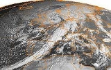
The Great Storm of 1987 occurred on the night of 15/16 October 1987, when an unusually strong weather system caused winds to hit much of southern England
Southern England
Southern England, the South and the South of England are imprecise terms used to refer to the southern counties of England bordering the English Midlands. It has a number of different interpretations of its geographic extents. The South is considered by many to be a cultural region with a distinct...
and northern France
France
The French Republic , The French Republic , The French Republic , (commonly known as France , is a unitary semi-presidential republic in Western Europe with several overseas territories and islands located on other continents and in the Indian, Pacific, and Atlantic oceans. Metropolitan France...
. It was the worst storm to hit England since the Great Storm of 1703
Great Storm of 1703
The Great Storm of 1703 was the most severe storm or natural disaster ever recorded in the southern part of Great Britain. It affected southern England and the English Channel in the Kingdom of Great Britain...
(284 years earlier) and was responsible for the deaths of at least 22 people in England and France combined (18 in England, at least four in France).
According to the Beaufort scale
Beaufort scale
The Beaufort Scale is an empirical measure that relates wind speed to observed conditions at sea or on land. Its full name is the Beaufort Wind Force Scale.-History:...
of wind intensities, this storm
European windstorm
A European windstorm is a severe cyclonic windstorm associated with areas of low atmospheric pressure that track across the North Atlantic towards northwestern Europe. They are most common in the winter months...
had winds of hurricane force; however, the term hurricane refers to tropical cyclone
Tropical cyclone
A tropical cyclone is a storm system characterized by a large low-pressure center and numerous thunderstorms that produce strong winds and heavy rain. Tropical cyclones strengthen when water evaporated from the ocean is released as the saturated air rises, resulting in condensation of water vapor...
s originating in the North Atlantic or North Pacific.
Unanswered Questions