
Agriculture in Sudan
Encyclopedia

Sudan
Sudan , officially the Republic of the Sudan , is a country in North Africa, sometimes considered part of the Middle East politically. It is bordered by Egypt to the north, the Red Sea to the northeast, Eritrea and Ethiopia to the east, South Sudan to the south, the Central African Republic to the...
for about 61 percent of the working population. Approximately one-third of the total area of Sudan, the largest country on the African continent is suitable for agricultural development and heavier rainfall in the south permits both agriculture and herding by nomadic tribes.
Agricultural products in total account for about 95 percent of the country's exports. In 1998 there was an estimated 16.9 million hectares (41.8 million acres) of arable land and approximately 1.9 million hectares (4.7 million acres) set aside for irrigation, primarily in the north of the country along the banks of the Nile
Nile
The Nile is a major north-flowing river in North Africa, generally regarded as the longest river in the world. It is long. It runs through the ten countries of Sudan, South Sudan, Burundi, Rwanda, Democratic Republic of the Congo, Tanzania, Kenya, Ethiopia, Uganda and Egypt.The Nile has two major...
and other rivers. Cash crops (as of 1999) grown under irrigation in these areas include cotton
Cotton
Cotton is a soft, fluffy staple fiber that grows in a boll, or protective capsule, around the seeds of cotton plants of the genus Gossypium. The fiber is almost pure cellulose. The botanical purpose of cotton fiber is to aid in seed dispersal....
and cottonseed, which is of primary importance to the economy with 172,000 tons and 131,000 tons produced annually respectively,sesame
Sesame
Sesame is a flowering plant in the genus Sesamum. Numerous wild relatives occur in Africa and a smaller number in India. It is widely naturalized in tropical regions around the world and is cultivated for its edible seeds, which grow in pods....
(220,000 tons), sugarcane
Sugarcane
Sugarcane refers to any of six to 37 species of tall perennial grasses of the genus Saccharum . Native to the warm temperate to tropical regions of South Asia, they have stout, jointed, fibrous stalks that are rich in sugar, and measure two to six metres tall...
(5,950,000 tons), peanuts
Peanuts
Peanuts is a syndicated daily and Sunday American comic strip written and illustrated by Charles M. Schulz, which ran from October 2, 1950, to February 13, 2000, continuing in reruns afterward...
(980,000 tons), dates (176,000 tons), citrus fruits, yams
Yam (vegetable)
Yam is the common name for some species in the genus Dioscorea . These are perennial herbaceous vines cultivated for the consumption of their starchy tubers in Africa, Asia, Latin America and Oceania...
(136,000 tons), tomatoes (240,000 tons), mangoes, coffee
Coffee
Coffee is a brewed beverage with a dark,init brooo acidic flavor prepared from the roasted seeds of the coffee plant, colloquially called coffee beans. The beans are found in coffee cherries, which grow on trees cultivated in over 70 countries, primarily in equatorial Latin America, Southeast Asia,...
, and tobacco
Tobacco
Tobacco is an agricultural product processed from the leaves of plants in the genus Nicotiana. It can be consumed, used as a pesticide and, in the form of nicotine tartrate, used in some medicines...
. The main subsistence crops produced in Sudan are sorghum
Sorghum
Sorghum is a genus of numerous species of grasses, one of which is raised for grain and many of which are used as fodder plants either cultivated or as part of pasture. The plants are cultivated in warmer climates worldwide. Species are native to tropical and subtropical regions of all continents...
(3,045,000 tons), millet
Millet
The millets are a group of small-seeded species of cereal crops or grains, widely grown around the world for food and fodder. They do not form a taxonomic group, but rather a functional or agronomic one. Their essential similarities are that they are small-seeded grasses grown in difficult...
(1,499,000 tons), wheat
Wheat
Wheat is a cereal grain, originally from the Levant region of the Near East, but now cultivated worldwide. In 2007 world production of wheat was 607 million tons, making it the third most-produced cereal after maize and rice...
(168,000 tons), cowpeas, beans, pulses, corn
Maize
Maize known in many English-speaking countries as corn or mielie/mealie, is a grain domesticated by indigenous peoples in Mesoamerica in prehistoric times. The leafy stalk produces ears which contain seeds called kernels. Though technically a grain, maize kernels are used in cooking as a vegetable...
(65,000), and barley
Barley
Barley is a major cereal grain, a member of the grass family. It serves as a major animal fodder, as a base malt for beer and certain distilled beverages, and as a component of various health foods...
. Cotton is the principal export crop and an integral part of the country's economy and Sudan is the world's third largest producer of sesame aftfer India
India
India , officially the Republic of India , is a country in South Asia. It is the seventh-largest country by geographical area, the second-most populous country with over 1.2 billion people, and the most populous democracy in the world...
and China
China
Chinese civilization may refer to:* China for more general discussion of the country.* Chinese culture* Greater China, the transnational community of ethnic Chinese.* History of China* Sinosphere, the area historically affected by Chinese culture...
.
Growth trends
The average annual growth of agricultural production declined in the 1980s to 0.8 percent for the period 1980-87, as compared with 2.9 percent for the period 1965-80. Similarly, the sector's total contribution to GDP declined over the years, as the other sectors of the economy expanded. Total sectoral activities, which contributed an estimated 40 percent of GDP in the early 1970s, had fluctuated during the 1980s and represented about 36 percent in 1988. Crop cultivation was divided between a modern, market-oriented sector comprising mechanizedMechanized
Mechanized refers to the use of machines. Related articles:*Mechanised agriculture*Mechanization* For "Mechanized artillery", see Self-propelled artillery* For "Mechanized force" and "Mechanized warfare", see Armoured warfare*Mechanized infantry...
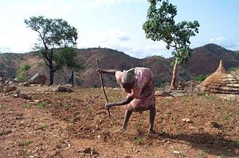
, large-scale irrigated and rainfed farming (mainly in central Sudan) and small-scale farming following traditional practices that was carried on in the other parts of the country where rainfall or other water sources were sufficient for cultivation.
Large investments continued to be made in the 1980s in mechanized, irrigated, and rainfed cultivation, with their combined areas accounting for roughly two-thirds of Sudan's cultivated land in the late 1980s. The early emphasis on cotton growing on irrigated land had decreased. Although cotton remained the most important crop, peanuts
Peanuts
Peanuts is a syndicated daily and Sunday American comic strip written and illustrated by Charles M. Schulz, which ran from October 2, 1950, to February 13, 2000, continuing in reruns afterward...
, wheat
Wheat
Wheat is a cereal grain, originally from the Levant region of the Near East, but now cultivated worldwide. In 2007 world production of wheat was 607 million tons, making it the third most-produced cereal after maize and rice...
, and sugarcane
Sugarcane
Sugarcane refers to any of six to 37 species of tall perennial grasses of the genus Saccharum . Native to the warm temperate to tropical regions of South Asia, they have stout, jointed, fibrous stalks that are rich in sugar, and measure two to six metres tall...
had become major crops, and considerable quantities of sesame also were grown. Rainfed mechanized farming continued to produce mostly sorghum
Sorghum
Sorghum is a genus of numerous species of grasses, one of which is raised for grain and many of which are used as fodder plants either cultivated or as part of pasture. The plants are cultivated in warmer climates worldwide. Species are native to tropical and subtropical regions of all continents...
, and short-fiber cotton
Cotton
Cotton is a soft, fluffy staple fiber that grows in a boll, or protective capsule, around the seeds of cotton plants of the genus Gossypium. The fiber is almost pure cellulose. The botanical purpose of cotton fiber is to aid in seed dispersal....
was also grown. Production in both subsectors increased domestic supplies and export potentials. The increase appeared, however, to have been achieved mainly by expanding the cultivated area rather than by increasing productivity. To stimulate productivity, in 1981 the government offered various incentives to cultivators of irrigated land who were almost entirely government tenants. Subsistence cultivators produced sorghum as their staple crop, although in the northerly, rainfed, cultivated areas millet was the principal staple. Subsistence farmers also grew peanuts and sesame.
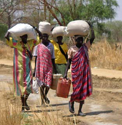
Livestock raising, pursued throughout Sudan except in the extremely dry areas of the north and the tsetse-fly-infested area in the far south, was almost entirely in the traditional sector. Camel farming
Camel farming in Sudan
Over the past few decades camels have regained recognition for their food-producing potential in arid and semi-arid areas of Sudan. After having been dismissed as uneconomical by the Sudanese government, their vital role in supporting human populations in some of the poorest and frequently...
is particularly popular. Because livestock raising provided employment for so many people, modernization proposals have been based on improving existing practices and marketing for export, rather than moving toward the modern ranching that requires few workers.
By 1991 only partial surveys of Sudan's land resources had been made, and estimates of the areas included in different landuse categories varied considerably. Figures for potentially arable land ranged from an estimate of 35.9 million hectares made in the mid-1960s to a figure of 84 million hectares published by the Ministry of Agriculture and Natural Resources in 1974. Estimates of the amount actually under cultivation varied in the late 1980s, ranging from 7.5 million hectares, including roughly 10 or 11 percent in fallow, to 12.6 million hectares.
Substantial variations also existed in land classified as actually used or potentially usable for livestock grazing. The ministry and the United Nations Food and Agriculture Organization (FAO) have classified about 24 million hectares as pastureland. The 1965 estimate of land use classified 101.4 million hectares as grazing land, and in 1975 an ILO-United Nations Development Programme
United Nations Development Programme
The United Nations Development Programme is the United Nations' global development network. It advocates for change and connects countries to knowledge, experience and resources to help people build a better life. UNDP operates in 177 countries, working with nations on their own solutions to...
(UNDP) interagency mission to Sudan estimated the total potential grazing land at between 120 million and 150 million hectares.
Forestland estimates also differed greatly, from less than 60 million hectares by staff of the Forestry Administration to about 915 million hectares by the Ministry of Agriculture and Natural Resources and the FAO. Dense stands of tree
Tree
A tree is a perennial woody plant. It is most often defined as a woody plant that has many secondary branches supported clear of the ground on a single main stem or trunk with clear apical dominance. A minimum height specification at maturity is cited by some authors, varying from 3 m to...
s only covered between 20 million and 24 million hectares of the total forestland. Differences in land classification may have been accounted for by use of some woodland areas for grazing and some traditional grazing lands for raising crops. Given the dearth of rainfall during the 1980s and early 1990s, the ecological damage from mechanized farming, and the steady march of desertification, discrepancies in these statistics had little meaning in 1991.
It was generally agreed, however, that in the late 1980s Sudan still had a substantial amount of land suitable for future cropping. The ILO-UNDP mission believed that two-thirds of the potential area for livestock grazing, however, was already in use. In addition to land suitable for cultivation
Tillage
Tillage is the agricultural preparation of the soil by mechanical agitation of various types, such as digging, stirring, and overturning. Examples of human-powered tilling methods using hand tools include shovelling, picking, mattock work, hoeing, and raking...
and livestock grazing, Sudan also had about 76 million to 86 million hectares of desert. Additionally, an area of about 2.9 million hectare
Hectare
The hectare is a metric unit of area defined as 10,000 square metres , and primarily used in the measurement of land. In 1795, when the metric system was introduced, the are was defined as being 100 square metres and the hectare was thus 100 ares or 1/100 km2...
s was covered by swamp
Swamp
A swamp is a wetland with some flooding of large areas of land by shallow bodies of water. A swamp generally has a large number of hammocks, or dry-land protrusions, covered by aquatic vegetation, or vegetation that tolerates periodical inundation. The two main types of swamp are "true" or swamp...
s and inland water, and about 280,000 hectares were occupied by urban settlements and other man-made features.
Land Tenure
The right to own property, to bequeath it to heirs, and to inherit it was established by the Permanent Constitution of 1973; this right was suspended in 1985. Sudan had long had a system of land registration through which an individual, an enterprise, or the government could establish title to a piece of land. Such registration had been extensive in northern Sudan, especially in Al Khartum, Al Awsat, and Ash Shamali provinces. Before 1970 all other land (unregistered) belonged to the state, which held ownership in trust for the people, who had customary rights to it. In 1970 the Unregistered Land Act declared that all waste, forest, and unregistered lands were government land. Before the act's passage, the government had avoided interfering with individual customary rights to unregistered land, and in the late 1980s it again adhered to this policy.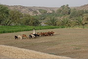
Pasture
Pasture is land used for grazing. Pasture lands in the narrow sense are enclosed tracts of farmland, grazed by domesticated livestock, such as horses, cattle, sheep or swine. The vegetation of tended pasture, forage, consists mainly of grasses, with an interspersion of legumes and other forbs...
and for subsistence cultivation was communally owned under customary land laws that varied somewhat by location but followed a broadly similar pattern. In agricultural communities, the right to cultivate an area of unused land became vested in the individual who cleared it for use. The rights to such land could be passed on to heirs, but ordinarily the land could not be sold or otherwise disposed of. The right was also retained to land left in fallow, although in Bahr al Ghazal, Aali an Nil, and Al Istiwai there were communities where another individual could claim such land by clearing it.
Among the transhumant communities of the north, the rights to cultivated land were much the same, but the dominant position of livestock in community activities had introduced certain other communal rights that included common rights to grazing land, the right-of-way to water and grazing land, the right to grass on agricultural land unless the occupier cut and stacked it, and the right to crop residues unless similarly treated. In the western savanna
Savanna
A savanna, or savannah, is a grassland ecosystem characterized by the trees being sufficiently small or widely spaced so that the canopy does not close. The open canopy allows sufficient light to reach the ground to support an unbroken herbaceous layer consisting primarily of C4 grasses.Some...
s, private ownership of stands of hashab trees could be registered, an exception to the usual government ownership of the forests. But dead wood for domestic fuel
Fuel
Fuel is any material that stores energy that can later be extracted to perform mechanical work in a controlled manner. Most fuels used by humans undergo combustion, a redox reaction in which a combustible substance releases energy after it ignites and reacts with the oxygen in the air...
and the underlying grass were common property. Water, a matter of greatest importance to stock raisers, was open to all if free standing, but wells that had been dug and the associated drinking troughs were private property and were retained by the digger season after season. In northern Sudan, especially in the western savanna where increasing population and animal numbers have placed pressure on the land, violations of customary laws and conflicts between ethnic groups over land rights have been growing. Resolution of these problems has been attempted by local government agencies but only on a case-by-case basis.
Irrigated Agriculture
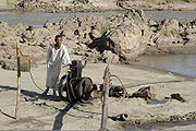
Irrigation
Irrigation may be defined as the science of artificial application of water to the land or soil. It is used to assist in the growing of agricultural crops, maintenance of landscapes, and revegetation of disturbed soils in dry areas and during periods of inadequate rainfall...
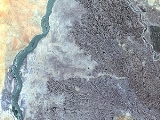
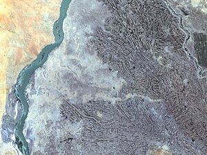
agriculture sector totaling more than 2 million hectares out of about 84 million hectares that are potentially arable. About 93 percent of the irrigated area was in government projects; the remaining 7 percent belonged to private operations. The Nile and its tributaries were the source of water for 93 percent of irrigated agriculture, and of this the Blue Nile accounted for about 67 percent. Gravity flow was the main form of irrigation, but about one-third of the irrigated area was served by pumps.
History
The waters of the Nile in Sudan have been used for centuries for traditional irrigation, taking advantage of the annual Nile flood. Some use of this method still continued in the early 1990s, and the traditional shaduf (a device to raise water) and waterwheel were also used to lift water to fields in local irrigation projects but were rapidly being replaced by more efficient mechanized pump systems. Among the first efforts to employ irrigation for modern commercial cropping was the use of the floodwaters of the Qash River and the Baraka River (both of which originate in EthiopiaEthiopia
Ethiopia , officially known as the Federal Democratic Republic of Ethiopia, is a country located in the Horn of Africa. It is the second-most populous nation in Africa, with over 82 million inhabitants, and the tenth-largest by area, occupying 1,100,000 km2...
) in eastern Sudan to grow cotton on their deltas. This project was started in the late 1860s by the Egypt
Egypt
Egypt , officially the Arab Republic of Egypt, Arabic: , is a country mainly in North Africa, with the Sinai Peninsula forming a land bridge in Southwest Asia. Egypt is thus a transcontinental country, and a major power in Africa, the Mediterranean Basin, the Middle East and the Muslim world...
ian governor and continued until interrupted by the turbulent period of the 1880s, leading to the reconquest of the country by the British
United Kingdom
The United Kingdom of Great Britain and Northern IrelandIn the United Kingdom and Dependencies, other languages have been officially recognised as legitimate autochthonous languages under the European Charter for Regional or Minority Languages...
in 1899. Cultivation was resumed in 1896 in the Baraka Delta in the Tawkar area, but in the Qash Delta it only resumed after World War I. Between 1924 and 1926, canals were built in the latter delta to control the flood; sandstorms made canals unfeasible in the Baraka. Between the 1940s and the 1970s, various projects were developed to irrigate land. In 1982 both deltas yielded only one crop a year, watered by the flood. Adequate groundwater, however, offered the eventual possibility of using pump irrigation from local wells for additional cropping or for supplementing any flood shortages.
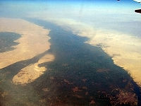
As of 1990, the country's largest irrigation project had been developed on land between the Blue and White Nile rivers south of their confluence at Khartoum
Khartoum
Khartoum is the capital and largest city of Sudan and of Khartoum State. It is located at the confluence of the White Nile flowing north from Lake Victoria, and the Blue Nile flowing west from Ethiopia. The location where the two Niles meet is known as "al-Mogran"...
. This area is generally flat with a gentle slope to the north and west, permitting natural gravity irrigation, and its soils are fertile cracking clays well suited to irrigation. The project originated in 1911, when a private British enterprise, Sudan Plantations Syndicate, found cotton suited to the area and embarked on what in the 1920s became the Gezira Scheme
Gezira Scheme
The Gezira Scheme is one of the largest irrigation projects in the world. It is centered on the Sudanese state of Al Jazirah, just southeast of the confluence of the Blue and White Nile rivers at the city of Khartoum. The economy of Sudan was historically based on agriculture prior to the...
, intended principally to furnish cotton to the British textile industry. Backed by a loan from the British government, the syndicate began a dam on the Blue Nile
Blue Nile
The Blue Nile is a river originating at Lake Tana in Ethiopia. With the White Nile, the river is one of the two major tributaries of the Nile...
at Sannar in 1913. Work was interrupted by World War I
World War I
World War I , which was predominantly called the World War or the Great War from its occurrence until 1939, and the First World War or World War I thereafter, was a major war centred in Europe that began on 28 July 1914 and lasted until 11 November 1918...
, and the dam was not completed until 1925. The project was limited by a 1929 agreement between Sudan and Egypt that restricted the amount of water Anglo-Egyptian Sudan could use during the dry season. By 1931 the project had expanded to 450000 hectares (1,111,973.2 acre), the maximum that then could be irrigated by the available water, although an additional 10000 hectares (24,710.5 acre) were added in the 1950s. The project was nationalized in 1950, and was operated by the Sudan Gezira Board as a government enterprise. In 1959 a new agreement with Egypt greatly increased the allotment of water to Sudan, as did the completion in the early 1960s of the Manaqil Extension on the western side of the Gezira Scheme. By 1990 the Manaqil Extension had an irrigated area of nearly 400000 hectares (988,420.7 acre) hectares, and with the 460000 hectares (1,136,683.7 acre) eventually attained by the original Gezira Scheme, the combined projects accounted for half the country's total land under irrigation.
Lake Nasser
Lake Nasser is a vast reservoir in southern Egypt, and northern Sudan, and is one of the largest man-made lakes in the world. Strictly, "Lake Nasser" refers only to the much larger portion of the lake that is in Egyptian territory , with the Sudanese preferring to call their smaller body of water...
in Egypt), which was formed by the construction of the Aswan High Dam in Egypt. To provide farmland for the Nubians, the government constructed the Khashm al Qirbah Dam on the Atbarah River
Atbarah River
The Atbarah River in northeast Africa rises in northwest Ethiopia, approximately 50 km north of Lake Tana and 30 km west of Gondar. It flows about 805 km to the Nile in north-central Sudan, joining it at the city of Atbarah...
and established the Halfa al Jadidah (New Halfa) irrigation project. Located west of Kassala
Kassala
Kassala is the capital of the state of Kassala in eastern Sudan. Its 2008 population was recorded to be 419,030. It is a market town and is famous for its fruit gardens. It was formerly a railroad hub, however, as of 2006 there was no operational railway station in Kassala and much of the track...
, this project was originally designed to irrigate about 164000 hectares (405,252.5 acre). In 1982 it was the only large irrigation project in the country that did not use the waters of the Blue Nile or White Nile. The resettlement was effected mainly after completion of the Khashm al Qirbah Dam in 1964. Part of the irrigated area was also assigned to local inhabitants. The main commercial crops initially introduced included cotton, peanuts, and wheat. In 1965 sugarcane was added, and a sugar factory having a design capacity of 60,000 tons was built to process it. The project enabled 200000 hectares (494,210.3 acre) of land to be irrigated for the first time. Heavy silting as well as serious problems of drainage
Drainage
Drainage is the natural or artificial removal of surface and sub-surface water from an area. Many agricultural soils need drainage to improve production or to manage water supplies.-Early history:...
and salinity
Salinity
Salinity is the saltiness or dissolved salt content of a body of water. It is a general term used to describe the levels of different salts such as sodium chloride, magnesium and calcium sulfates, and bicarbonates...
occurred. As a result, by the late 1970s the reservoir
Reservoir
A reservoir , artificial lake or dam is used to store water.Reservoirs may be created in river valleys by the construction of a dam or may be built by excavation in the ground or by conventional construction techniques such as brickwork or cast concrete.The term reservoir may also be used to...
had lost more than 40 percent of its original storage capacity and was unable to meet the project water requirements. These problems persisted in the early 1990s.
The multipurpose Roseires Dam
Roseires Dam
The Roseires Dam is a dam on the Blue Nile at Ad Damazin, just upstream of the town of Er Roseires, in Sudan. It consists of a concrete buttress dam 1 km wide with a maximum height of 68m, and an earth dam on either side. The earth dam on the eastern bank is 4 km long, and that on the...
was built in 1966 and power- generating facilities were installed in 1971. Both the water and the power were needed to implement the Rahad River irrigation project located east of the Rahad River
Rahad River
The Rahad is a river of western Ethiopia, and a tributary of the Abay on the right side....
, a tributary of the Blue Nile. The Rahad entered the Blue Nile downstream from the dam and during the dry season had an insufficient flow for irrigation purposes. Work on the initial 63000 hectares (155,676.3 acre) of the project began in the early 1970s, the first irrigation water was received in 1977, and by 1981 about 80 percent of the prepared area was reported to be irrigated. (In May 1988, the World Bank
World Bank
The World Bank is an international financial institution that provides loans to developing countries for capital programmes.The World Bank's official goal is the reduction of poverty...
agreed to provide additional funding for this and other irrigation projects). Water for the project was pumped from the Blue Nile, using electric power from the Roseires plant, and was transported by an eighty-kilometer-long canal to the Rahad River (en route underpassing the Dindar River, another Blue Nile tributary). The canal then emptied into the Rahad above a new barrage
Barrage (dam)
A barrage is a type of dam which consists of a line of large gates that can be opened or closed to control the amount of water passing the dam. The gates are set between flanking piers which are responsible for supporting the water load...
that diverted the combined flow from the two sources into the project's main irrigation canal. Irrigation was by gravity flow, but instead of flat field flooding, furrow irrigation was used, because it permitted more effective use of machinery.
In the 1920s, private irrigation projects using diesel pumps also had begun to appear in Al Khartum Province, mainly along the White Nile, to provide vegetables, fruit, and other foods to the capital area. In 1937 a dam was built by the Anglo-Egyptian condominium upstream from Khartoum on the White Nile at Jabal al Awliya to regulate the supply of water to Egypt during the August to April period of declining flow. Grazing and cultivated land along the river was flooded for almost 300 kilometres (186.4 mi). The government thereupon established seven pump irrigation projects, partially financed by Egypt, to provide the area's inhabitants with an alternative to transhumance.
This irrigation project eventually proved successful, making possible large surpluses of cotton and sorghum and encouraging private entrepreneurs to undertake new projects. High cotton profits during the Korean War
Korean War
The Korean War was a conventional war between South Korea, supported by the United Nations, and North Korea, supported by the People's Republic of China , with military material aid from the Soviet Union...
(1950–53) increased private interest along the Blue Nile as well, and by 1958 almost half the country's irrigated cotton was grown under pump irrigation. During the 1960s, however, downward fluctuations in world cotton prices and disputes between entrepreneurs and tenants led to numerous failures of pump irrigation projects. In 1968 the government assumed ownership and operation of the projects, establishing the Agricultural Reform Corporation for this purpose, and the takeover began that year with the larger estates. Subsequently, as leases expired, the corporation acquired smaller projects, until May 1970 when all outstanding leases were revoked. A considerable number of small pump operations that developed on privately owned land, chiefly along the main Nile but also on the Blue Nile, continued to operate.
Japan
Japan is an island nation in East Asia. Located in the Pacific Ocean, it lies to the east of the Sea of Japan, China, North Korea, South Korea and Russia, stretching from the Sea of Okhotsk in the north to the East China Sea and Taiwan in the south...
ese-assisted As Suki project, also of 36000 hectares (88,957.9 acre), was established upstream from Sannar to grow cotton, sorghum, and oilseeds. In the mid-1970s, the government constructed a second project near Sannar of about 20000 hectares (49,421 acre) hectares. In addition to cotton and other crops such as peanuts, about 8400 hectares (20,756.8 acre) of the area were devoted to raising sugarcane. The cane-processing factory, with a design capacity of 110,000 tons of sugar a year, opened in 1976. Several smaller Blue Nile projects added more than an additional 80000 hectares (197,684.1 acre) to Sudan's overall irrigated area during this time.
In the 1970s, when the consumption and import of sugar grew rapidly, domestic production became a priority, and two major pump-irrigated sugar plantations were established on the White Nile in the Kusti area. The Hajar Asalaya Sugar Project, begun in 1975, had an irrigated area of about 7,600 hectares. The sugar factory, completed in 1977, had a potential annual capacity of 110,000 tons. The Kinanah Sugar Project, which had almost 16200 hectares (40,031 acre) under irrigation in 1981 and had a future potential of over 33000 hectares (81,544.7 acre), was one of the world's largest sugar- milling and refining operations. In 1985-86 production reached more than 330,000 tons a year. This project, first proposed in 1971, was beset with funding problems and overruns that increased overall costs from the equivalent of US$113 million estimated in 1973 to more than US$750 million when the plant opened officially in early 1981.
The Kinanah Sugar Project, unlike the country's four other government-owned sugar projects, was a joint venture—among the governments of Sudan, Kuwait
Kuwait
The State of Kuwait is a sovereign Arab state situated in the north-east of the Arabian Peninsula in Western Asia. It is bordered by Saudi Arabia to the south at Khafji, and Iraq to the north at Basra. It lies on the north-western shore of the Persian Gulf. The name Kuwait is derived from the...
, and Saudi Arabia
Saudi Arabia
The Kingdom of Saudi Arabia , commonly known in British English as Saudi Arabia and in Arabic as as-Sa‘ūdiyyah , is the largest state in Western Asia by land area, constituting the bulk of the Arabian Peninsula, and the second-largest in the Arab World...
, and the Arab Investment Company, the Sudan Development Corporation, Kinanah Limited, and the AAAID, including local Sudanese banks. An initial trial run in the 1979-80 cane season produced 20,000 tons of sugar. Yield increased to an estimated 135,000 to 150,000 tons the following season. Production at the Hajar Asalaya factory did not get under way until the 1979-80 season because of cane and sugar-processing difficulties. Problems have also affected the other three state sugar factories, but as a result of proposed World Bank management, the output total of these four government operations for the 1984-85 season improved to nearly 200,000 tons. Output declined to 159,000 tons in 1985-86 because of the drought. In 1989 sugarcane production reached 400,000 tons.
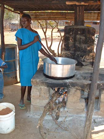
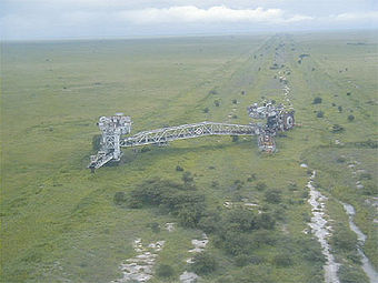
Rainfed Agriculture
Cultivation dependent on rainfall falls into two categories. Most Sudanese farmers always have relied on rainfed farming. In addition to these traditional farmers, a large modern mechanized rainfed agriculture sector has developed since 1944-45, when a government project to cultivate the cracking clays of central Sudan started in the Al QadarifAl Qadarif
Al Qadarif , also spelt Gedaref, Gedarif or El Gadarif, is the capital of the state of Al Qadarif in Sudan. It lies on the road that connects Khartoum with Gallabat on the Ethiopian border, about 410 kilometers from the capital.-Overview:...
area of Ash Sharqi Province, largely to meet the food needs of army units stationed in the British colonies in eastern Africa (present-day Kenya
Kenya
Kenya , officially known as the Republic of Kenya, is a country in East Africa that lies on the equator, with the Indian Ocean to its south-east...
, Tanzania
Tanzania
The United Republic of Tanzania is a country in East Africa bordered by Kenya and Uganda to the north, Rwanda, Burundi, and the Democratic Republic of the Congo to the west, and Zambia, Malawi, and Mozambique to the south. The country's eastern borders lie on the Indian Ocean.Tanzania is a state...
, and Uganda
Uganda
Uganda , officially the Republic of Uganda, is a landlocked country in East Africa. Uganda is also known as the "Pearl of Africa". It is bordered on the east by Kenya, on the north by South Sudan, on the west by the Democratic Republic of the Congo, on the southwest by Rwanda, and on the south by...
). An average of about 6,000 hectares a year was cultivated between 1945 and 1953, producing chiefly sorghum, under a sharecropping arrangement between the government and farmers who had been allocated land in the project. These estates proved costly, however, and in 1954 the government began encouraging the private sector to take up mechanized farming in the area, a policy that continued after Sudan gained independence in 1956. Under the new approach, the government established several state farms to demonstrate production methods and to conduct research
Research
Research can be defined as the scientific search for knowledge, or as any systematic investigation, to establish novel facts, solve new or existing problems, prove new ideas, or develop new theories, usually using a scientific method...
. Research activities have been very limited, however, because of staffing and funding problems, and the farms have been operated essentially as regular production units.
The investment
Investment
Investment has different meanings in finance and economics. Finance investment is putting money into something with the expectation of gain, that upon thorough analysis, has a high degree of security for the principal amount, as well as security of return, within an expected period of time...
requirements for mechanized farming favored prosperous cultivators, and eventually most farms came to be operated by entrepreneur
Entrepreneur
An entrepreneur is an owner or manager of a business enterprise who makes money through risk and initiative.The term was originally a loanword from French and was first defined by the Irish-French economist Richard Cantillon. Entrepreneur in English is a term applied to a person who is willing to...
s who raised capital through mortgageable property or other assets in the urban centers. Through arrangements with other individuals, these entrepreneurs frequently managed to control additional plots beyond the legal limit of two. Their ability to obtain capital also permitted them to abandon depleted land and to move into newly demarcated uncleared areas, a practice that had a deleterious impact upon the environment, deprived the indigenous inhabitants of work opportunities, and increased desertification. In 1968, to expand the operator base and to introduce more control over land allocation, crops, and farming methods, the government established the Mechanized Farming Corporation (MFC), an autonomous agency under the Ministry of Agriculture and Natural Resources. From 1968 through 1978, the IDA made three loans to the government to enable the MFC to provide technical assistance, credit for landclearing and machinery, and marketing aid to individual farmers and cooperative groups. The MFC also became the operator of state farms.
Nuba Mountains
Nuba Mountains is an area located in South Kordofan, Sudan. The area is home to a group of indigenous ethnic groups known collectively as the Nuba peoples. In the 18th century, Nuba Mountains became home to the kingdom of Taqali that controlled the hills of the mountains until their defeat by...
, but under a different government program. Proposals also have been made for MFC projects using mechanized equipment in other areas of southern Kurdufan (some have already been tried) and southern Darfur
Darfur
Darfur is a region in western Sudan. An independent sultanate for several hundred years, it was incorporated into Sudan by Anglo-Egyptian forces in 1916. The region is divided into three federal states: West Darfur, South Darfur, and North Darfur...
provinces. There were serious feasibility problems in view of competition for land and conflicts with traditional farming practices, difficult soil conditions, and the probable negative effect on the large numbers of livestock of nomads.
Only a few crops had been found suitable for cultivation in the cracking clay area. Sorghum had been the principal one, and during the early 1980s it was planted on an average of about 80 percent of the sown area. Sesame and short-fiber cotton were also grown successfully but in smaller quantities, sesame on about 15 percent of the land and cotton on about 5 percent. Soil fertility has reportedly been declining because of the continued planting of sorghum and the lack of crop rotation. Yields have apparently decreased, but in view of the area's greatly varying climatic conditions and the uncertain production data, definitive conclusions on trends appeared premature.
Fishing
Red Sea
The Red Sea is a seawater inlet of the Indian Ocean, lying between Africa and Asia. The connection to the ocean is in the south through the Bab el Mandeb strait and the Gulf of Aden. In the north, there is the Sinai Peninsula, the Gulf of Aqaba, and the Gulf of Suez...
, were small.
Forestry
The forestry subsector comprised both traditional gatherers of firewood and producers of charcoalCharcoal
Charcoal is the dark grey residue consisting of carbon, and any remaining ash, obtained by removing water and other volatile constituents from animal and vegetation substances. Charcoal is usually produced by slow pyrolysis, the heating of wood or other substances in the absence of oxygen...
--the main sources of fuel for homes and some industry in urban areas—and a modern timber and sawmilling industry, the latter government owned. Approximately 21 million cubic meters of wood, mainly for fuel, were cut in 1987. Gum arabic production in FY 1986-87 was about 40,000 tons. In the late 1980s, it became in most years the second biggest export after cotton, amounting to about 11 percent of total exports.