
Blue Nile
Encyclopedia
River
A river is a natural watercourse, usually freshwater, flowing towards an ocean, a lake, a sea, or another river. In a few cases, a river simply flows into the ground or dries up completely before reaching another body of water. Small rivers may also be called by several other names, including...
originating at Lake Tana
Lake Tana
Lake Tana is the source of the Blue Nile and is the largest lake in Ethiopia...
in Ethiopia
Ethiopia
Ethiopia , officially known as the Federal Democratic Republic of Ethiopia, is a country located in the Horn of Africa. It is the second-most populous nation in Africa, with over 82 million inhabitants, and the tenth-largest by area, occupying 1,100,000 km2...
. With the White Nile
White Nile
The White Nile is a river of Africa, one of the two main tributaries of the Nile from Egypt, the other being the Blue Nile. In the strict meaning, "White Nile" refers to the river formed at Lake No at the confluence of the Bahr al Jabal and Bahr el Ghazal rivers...
, the river is one of the two major tributaries of the Nile
Nile
The Nile is a major north-flowing river in North Africa, generally regarded as the longest river in the world. It is long. It runs through the ten countries of Sudan, South Sudan, Burundi, Rwanda, Democratic Republic of the Congo, Tanzania, Kenya, Ethiopia, Uganda and Egypt.The Nile has two major...
. The upper reaches of the river is called the Abbay in Ethiopia, where it is considered holy by many, and is believed to be the River Gihon
Gihon
Gihon is the name of the second river mentioned in the second chapter of the biblical Book of Genesis. The Gihon is mentioned as one of four rivers issuing out of the Garden of Eden that branched from a single river within the garden. The name may be interpreted as "Bursting Forth, Gushing"...
mentioned as flowing out of the Garden of Eden
Garden of Eden
The Garden of Eden is in the Bible's Book of Genesis as being the place where the first man, Adam, and his wife, Eve, lived after they were created by God. Literally, the Bible speaks about a garden in Eden...
in Genesis 2.
Course
According to materials published by the Ethiopian Central Statistical AgencyCentral Statistical Agency (Ethiopia)
The Central Statistical Agency is an agency of the government of Ethiopia designated to provide all surveys and censuses for that country used to monitor economic and social growth, as well as to act as an official training center in that field. It is part of the Ethiopian Ministry of Finance and...
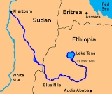
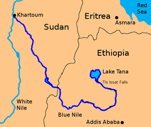
, the Blue Nile has a total length of 1450 kilometres (901 mi), of which 800 km (497.1 mi) are inside Ethiopia. The Blue Nile flows generally south from Lake Tana and then west across Ethiopia and northwest into Sudan. Within 30 kilometres (18.6 mi) of its source at Lake Tana, the river enters a canyon about 400 kilometres (248.5 mi) long. This gorge is a tremendous obstacle for travel and communication from the north half of Ethiopia to the southern half. The power of the Blue Nile may best be appreciated at Tis Issat Falls, which are 45 metres (147.6 ft) high, located about 40 kilometres (24.9 mi) downstream of Lake Tana.
Although there are several feeder streams that flow into Lake Tana, the sacred
Sacred
Holiness, or sanctity, is in general the state of being holy or sacred...
source of the river is generally considered to be a small spring at Gish Abbai
Gish Abay
Gish Abay is a town in west-central Ethiopia. Located in the Mirab Gojjam Zone of the Amhara Region, it is the administrative center of Sekela woreda. The town is named after the nearby Mount Gish and the Abay River whose source is in the foothills of the mountain...
at an altitude of approximately 2744 metres (9,002.6 ft). This stream, known as the Lesser Abay
Lesser Abay
Lesser Abay is a river of central Ethiopia. Rising in the mountains of Gojjam, it flows northward to empty into Lake Tana at . Tributaries of the Lesser Abay include the Ashar, Jamma, Kelti and the Koger....
, flows north into Lake Tana
Lake Tana
Lake Tana is the source of the Blue Nile and is the largest lake in Ethiopia...
. Other affluents of this lake include, in clockwise order from Gorgora
Gorgora
Gorgora is a town and peninsula in northwestern Ethiopia...
, the Magech, the Northern Gumara, the Reb
Reb River
Reb River is a river of north-central Ethiopia which empties into Lake Tana at . The river originates on the slopes of Mount Guna, and flows west through Kemekem woreda. It has no significant tributaries.R.E...
, the Southern Gumara
Gumara River
Gumara River is a river of northern-western Ethiopia and empties into Lake Tana at from the east. Hot springs on its banks at Wanzagay, which were popular in medicinal hot baths in the late 18th and early 19th centuries, are mentioned by the missionary Henry Stern.The river is an important...
and the Kilte. Lake Tana's outflow then flows some 30 kilometres before plunging over the Tis Issat Falls. The river then loops across northwest Ethiopia through a series of deep valleys and canyons into Sudan, by which point it is only known as the Blue Nile.
There are numerous tributaries of the Abay between Lake Tana and the Sudanese border. Those on its left bank, in downstream order, include the Wanqa River, the Bashilo River
Bashilo River
The Bashilo River is located in Ethiopia. Known for its canyon, which one source describes as almost as extensive as the canyon of its parent the Abay, also known as the Blue Nile, the river originates just west of Kutaber in the Amhara Region, flowing first to the northwest to where the Tergiya...
, the Walaqa River
Walaqa River
Walaqa River, a tributary of the Blue Nile, is an Ethiopian river in the Amhara Region. Wegde is located to its north. Mida Woremo and Dera are to the south, while Kelala is to the northeast. The Walaqa River may have been the northern boundary of the historical province of Walaqa.-External links:* *...
, the Wanchet River
Wanchet River
Wanchet River is a river of central Ethiopia, and a tributary of the Jamma River. Along with the Adabay River, it defined the border of the former district of Marra Biete. Its crossing "Aqui afagi" is mentioned in the account of Francisco Álvares, who crossed it several times in the first quarter...
, the Jamma River
Jamma River
The Jamma River is a river in central Ethiopia and a tributary of the Abay on its right side. It drains parts of the Semien Shewa Zones of the Amhara and Oromia Regions. The Upper Jamma flows through steep, deep canyons cut first through volcanic rock and then through the Cretaceous sandstone and...
, the Muger River
Muger River
The Muger River is a north-flowing tributary of the Abay River in central Ethiopia, which is notable for its deep gorge. Its confluence with the Abay is at . Tributaries of the Muger include the Labbu...
, the Guder River
Guder River
The Guder is a river of central Ethiopia. It is a tributary of the Abay or Blue Nile on the left side; tributaries of the Guder include the Dabissa and the Taranta. The Guder has a drainage area is about 7,011 square kilometers in size....
, the Agwel River, the Nedi River, the Didessa River
Didessa River
The Didessa River is a river in western Ethiopia. A tributary of the Abay River, it rises in the mountains of Gomma, flowing in a northwestern direction to its confluence where the course of the Abay has curved to its southernmost point before turning northwards at about...
and the Dabus River
Dabus River
The Dabus River is a north-flowing tributary of the Abay River in southwestern Ethiopia; it joins its parent stream at . The Dabus has a drainage area of about 21,032 square kilometers....
. Those on the right side, also in downstream order, include the Handassa, Tul, Abaya, Sade, Tammi, Cha, Shita, Suha, Muga, Gulla River, Temcha, Bachat, Katlan, Jiba, Chamoga, Weter and the Beles
Beles River
Beles River is a river of western Ethiopia. A tributary of the Abay river , the Beles rises in Dangur woreda to flow in a south-west direction to its confluence. Its catchment area amounts to about 14,200 square kilometers....
.
After flowing past Er Roseires
Er Roseires
Er Roseires is a town in eastern Sudan 60km from the border with Ethiopia.Lord Prudhoe mentions this town in the 1829 diary he kept while travelling in the Sennar...
inside Sudan, and receiving the Dinder
Dinder River
The Dinder River is a tributary of the Blue Nile. It flows through Ethiopia and Sudan for .-Course:The Dinder River rises in the Ethiopian Highlands, west of Lake Tana in the Ethiopian woreda of Alefa. It flows northwest out of the highlands and into the plains of the Sudanese state of Sennar...
on its right bank at Dinder
Dinder, Sudan
Dinder is a town in eastern Sudan. It is located around the UNESCO Dinder National Park and the Dinder River of the same name flows in the area....
, the Blue Nile joins the White Nile
White Nile
The White Nile is a river of Africa, one of the two main tributaries of the Nile from Egypt, the other being the Blue Nile. In the strict meaning, "White Nile" refers to the river formed at Lake No at the confluence of the Bahr al Jabal and Bahr el Ghazal rivers...
at Khartoum
Khartoum
Khartoum is the capital and largest city of Sudan and of Khartoum State. It is located at the confluence of the White Nile flowing north from Lake Victoria, and the Blue Nile flowing west from Ethiopia. The location where the two Niles meet is known as "al-Mogran"...
and, as the River Nile, flows through Egypt
Egypt
Egypt , officially the Arab Republic of Egypt, Arabic: , is a country mainly in North Africa, with the Sinai Peninsula forming a land bridge in Southwest Asia. Egypt is thus a transcontinental country, and a major power in Africa, the Mediterranean Basin, the Middle East and the Muslim world...
to the Mediterranean Sea
Mediterranean Sea
The Mediterranean Sea is a sea connected to the Atlantic Ocean surrounded by the Mediterranean region and almost completely enclosed by land: on the north by Anatolia and Europe, on the south by North Africa, and on the east by the Levant...
at Alexandria
Alexandria
Alexandria is the second-largest city of Egypt, with a population of 4.1 million, extending about along the coast of the Mediterranean Sea in the north central part of the country; it is also the largest city lying directly on the Mediterranean coast. It is Egypt's largest seaport, serving...
. The Blue Nile is so-called because during flood times the water current is so high, it changes colour to an almost black; since in the local Sudanese language the word for black is also used for the colour blue.
The distance from its source to its confluence is variously reported as 1,460 and 1,600 kilometres (907 and 1,000 miles). The uncertainty over its length might partially result from the fact that it flows through a virtually impenetrable gorges cut in the Ethiopian Highlands
Ethiopian Highlands
The Ethiopian Highlands are a rugged mass of mountains in Ethiopia, Eritrea , and northern Somalia in the Horn of Africa...
to a depth of some 1500 metres (4,921.3 ft)—a depth comparable to that of the Grand Canyon
Grand Canyon
The Grand Canyon is a steep-sided canyon carved by the Colorado River in the United States in the state of Arizona. It is largely contained within the Grand Canyon National Park, the 15th national park in the United States...
of the Colorado River
Colorado River
The Colorado River , is a river in the Southwestern United States and northwestern Mexico, approximately long, draining a part of the arid regions on the western slope of the Rocky Mountains. The watershed of the Colorado River covers in parts of seven U.S. states and two Mexican states...
in the United States
United States
The United States of America is a federal constitutional republic comprising fifty states and a federal district...
.
Water flow
The flow of the Blue Nile reaches maximum volume in the rainy season (from June to September), when it supplies about two thirds of the water of the Nile proper. The Blue Nile, along with that of the Atbara River to the north, which also flows out of the Ethiopian Highlands, were responsible for the annual Nile floods that contributed to the fertility of the Nile Valley and the consequent rise of ancient Egyptian civilization and Egyptian MythologyEgyptian mythology
Ancient Egyptian religion was a complex system of polytheistic beliefs and rituals which were an integral part of ancient Egyptian society. It centered on the Egyptians' interaction with a multitude of deities who were believed to be present in, and in control of, the forces and elements of nature...
. With the completion in 1970 of the Aswan High Dam in Egypt, the Nile floods ended.
The Blue Nile is vital to the livelihood of Egypt
Egypt
Egypt , officially the Arab Republic of Egypt, Arabic: , is a country mainly in North Africa, with the Sinai Peninsula forming a land bridge in Southwest Asia. Egypt is thus a transcontinental country, and a major power in Africa, the Mediterranean Basin, the Middle East and the Muslim world...
. Though shorter than the White Nile, 59% of the water that reaches Egypt originates from the Blue Nile branch of the great river; when combined with the Atbara River, which also has its source in the Ethiopian Highlands
Ethiopian Highlands
The Ethiopian Highlands are a rugged mass of mountains in Ethiopia, Eritrea , and northern Somalia in the Horn of Africa...
, the figure rises to 90% of the water and 96% of transported sediment. The river is also an important resource for Sudan, where the Roseires
Roseires Dam
The Roseires Dam is a dam on the Blue Nile at Ad Damazin, just upstream of the town of Er Roseires, in Sudan. It consists of a concrete buttress dam 1 km wide with a maximum height of 68m, and an earth dam on either side. The earth dam on the eastern bank is 4 km long, and that on the...
and Sennar
Sennar Dam
The Sennar Dam is a dam on the Blue Nile near the town of Sennar, Sudan. It was built in 1925 by the British engineer, desert explorer and adventurer, Stephen "Roy" Sherlock, under the direction of Weetman Pearson. The dam is 3025 meters long, with a maximum height of 40 meters . It provides...
dams produce 80% of the country's power. These dams also help irrigate the Gezira Plain, which is most famous for its high quality cotton
Cotton
Cotton is a soft, fluffy staple fiber that grows in a boll, or protective capsule, around the seeds of cotton plants of the genus Gossypium. The fiber is almost pure cellulose. The botanical purpose of cotton fiber is to aid in seed dispersal....
. The region also produces wheat
Wheat
Wheat is a cereal grain, originally from the Levant region of the Near East, but now cultivated worldwide. In 2007 world production of wheat was 607 million tons, making it the third most-produced cereal after maize and rice...
and animal feed crops.
European exploration
The first European to have seen the Blue Nile in Ethiopia and the river's source was Pedro PaezPedro Páez
Pedro Páez Jaramillo was a Spanish Jesuit missionary in Ethiopia. Páez is considered by many experts on Ethiopia to be the most effective Catholic missionary in Ethiopia...
, a Spanish Jesuit who reached the river's source 21 April 1613. Nevertheless the Portuguese João Bermudes, the self-described Patriarch of Ethiopia, provided the first description of the Tis Issat Falls in his memoirs (published in 1565), and a number of Europeans who lived in Ethiopia in the late 15th century like Pêro da Covilhã
Pêro da Covilhã
Pedro or Pêro da Covilhã was a Portuguese diplomat and explorer.He was a native of Covilhã in Beira. In his early life he had gone to Castile and entered the service of Alphonso, Duke of Seville...
could have seen the river long before Paez, but not reached its places of source.
The source of the Blue Nile was also reached in 1629 by the Portuguese Jesuit missionary
Missionary
A missionary is a member of a religious group sent into an area to do evangelism or ministries of service, such as education, literacy, social justice, health care and economic development. The word "mission" originates from 1598 when the Jesuits sent members abroad, derived from the Latin...
Jerónimo Lobo
Jerónimo Lobo
Jerónimo Lobo was a Portuguese Jesuit missionary.He was born in Lisbon the third of at least five sons and six daughters to Francisco Lobo da Gama, the Governor of Cape Verde, and Dona Maria Brandão de Vasconcelos. He entered the Order of Jesus at the age of 14...
and in 1770 by James Bruce
James Bruce
James Bruce was a Scottish traveller and travel writer who spent more than a dozen years in North Africa and Ethiopia, where he traced the origins of the Blue Nile.-Youth:...
.
Although a number of European explorers contemplated tracing the course of the Blue Nile from its confluence with the White Nile to Lake Tana, its gorge, which begins a few miles inside the Ethiopian border, has discouraged all attempts since Frédéric Cailliaud
Frédéric Cailliaud
Frédéric Cailliaud was a French naturalist, mineralogist and conchologist. He was born, and died, in Nantes.He travelled in Egypt, Nubia, and Ethiopia, collecting minerals and making observations...
's attempt in 1821. The first serious attempt by a non-local to explore this reach of the river was undertaken by the American W.W. Macmillan in 1902, assisted by the Norwegian
Norway
Norway , officially the Kingdom of Norway, is a Nordic unitary constitutional monarchy whose territory comprises the western portion of the Scandinavian Peninsula, Jan Mayen, and the Arctic archipelago of Svalbard and Bouvet Island. Norway has a total area of and a population of about 4.9 million...
explorer B.H. Jenssen; Jenssen would proceed upriver from Khartoum while Macmillan sailed downstream from Lake Tana. However, Jenssen's boats were blocked by the rapids at Famaka short of the Sudan-Ethiopian border, and Macmillan's boats were wrecked shortly after they had been launched. Macmillan encouraged Jenssen to try to sail upstream from Khartoum again in 1905, but he was forced to stop 300 miles short of Lake Tana. Consul Cheesman, who records his surprise on arriving in Ethiopia at finding that the upper waters of "one of the most famous of the rivers of the world, and one whose name was well known to the ancients" was in his lifetime "marked on the map by dotted lines", managed to map the upper course of the Blue Nile between 1925–1933. He did this not by following the river along its banks and through its impassable canyon, but following it from the highlands above, travelling some 5000 miles (8,046.7 km) by mule in the adjacent country.
In 1968 at the request of Emperor Haile Selassie
Haile Selassie I of Ethiopia
Haile Selassie I , born Tafari Makonnen, was Ethiopia's regent from 1916 to 1930 and Emperor of Ethiopia from 1930 to 1974...
of Ethiopia, a team of 60 British and Ethiopian servicemen and scientists made the first descent of the Blue Nile from Lake Tana to a point near the Sudan border led by the eminent explorer Captain (now Colonel) John Blashford-Snell
John Blashford-Snell
Colonel John Nicholas Blashford-Snell OBE is a former British Army officer, explorer and author.John Blashford-Snell was educated at Victoria College, Jersey and at the Royal Military Academy Sandhurst, then commissioned into the Royal Engineers.Amongst his expeditions have been the first descent...
. The team used specially built Avon inflatables and modified Royal Engineer Assault boats to navigate the formidable rapids. This expedition made many important scientific discoveries. They also had to fight off two attacks by bandits.
In 1999, writer Virginia Morell http://www.bookreporter.com/reviews/0792279514.asp and photographer Nevada Wier made the journey by raft from Lake Tana to the Sudan, afterwards publishing a documentary about their journey. In 2000, American and National Geographic reader, Kenneth Frantz, saw a photo take by Nevada Wier for National Geographic which would lead him to found the charity Bridges to Prosperity
Bridges to Prosperity
Bridges to Prosperity is a United States-based nonprofit organization that builds footbridges and trains local people in developing countries to build pedestrian bridges...
. This photo showed a bridge broken during World War II, with 10 men on either side of the broken span pulling each other across the dangerous gap by rope. This historic bridge was built by Emporer Fasilides of Ethiopia
Fasilides of Ethiopia
Fasilides was of Ethiopia, and a member of the Solomonic dynasty...
in approximately 1660 with Roman bridge technology brought to Ethiopia by Portugese soldiers during the battle with the Muslim invaders in 1507.. In both 2001 and 2009, Bridges to Prosperity volunteers would travel from the USA to Ethiopia to repair the broken bridge across the Blue Nile river, and later build a new cable suspended span not susceptible to flood. Bridges to Prosperity has now built over 93 footbridges in 13 countries.
On April 28, 2004, geologist Pasquale Scaturro and his partner, kayaker and documentary filmmaker Gordon Brown, became the first people to navigate the Blue Nile. Though their expedition included a number of others, Brown and Scaturro were the only ones to remain on the expedition for the entire journey. They chronicled their adventure with an IMAX
IMAX
IMAX is a motion picture film format and a set of proprietary cinema projection standards created by the Canadian company IMAX Corporation. IMAX has the capacity to record and display images of far greater size and resolution than conventional film systems...
camera and two handheld video cams, sharing their story in the IMAX film Mystery of the Nile
Mystery of the Nile
Mystery of the Nile is a 2005 IMAX film documenting the first successful expedition to navigate the entire length of the Blue Nile and Nile from its source in Ethiopia to the Mediterranean Sea. The expedition was led by geologist Pasquale Scaturro. The journey took 114 days and was finished on...
and in a book of the same title. Despite this attempt, the team was forced to use outboard motor
Outboard motor
An outboard motor is a propulsion system for boats, consisting of a self-contained unit that includes engine, gearbox and propeller or jet drive, designed to be affixed to the outside of the transom and are the most common motorized method of propelling small watercraft...
s for most of their journey, and it was not until January 29, 2005, when Canadian
Canada
Canada is a North American country consisting of ten provinces and three territories. Located in the northern part of the continent, it extends from the Atlantic Ocean in the east to the Pacific Ocean in the west, and northward into the Arctic Ocean...
Les Jickling and New Zealand
New Zealand
New Zealand is an island country in the south-western Pacific Ocean comprising two main landmasses and numerous smaller islands. The country is situated some east of Australia across the Tasman Sea, and roughly south of the Pacific island nations of New Caledonia, Fiji, and Tonga...
er Mark Tanner reached the Mediterranean Sea
Mediterranean Sea
The Mediterranean Sea is a sea connected to the Atlantic Ocean surrounded by the Mediterranean region and almost completely enclosed by land: on the north by Anatolia and Europe, on the south by North Africa, and on the east by the Levant...
, that the river had been paddled for the first time under human power from source to sea.