

Vehicle registration plates of Ohio
Encyclopedia
Vehicle registration plate
A vehicle registration plate is a metal or plastic plate attached to a motor vehicle or trailer for official identification purposes. The registration identifier is a numeric or alphanumeric code that uniquely identifies the vehicle within the issuing region's database...
s are issued in the U.S. state
U.S. state
A U.S. state is any one of the 50 federated states of the United States of America that share sovereignty with the federal government. Because of this shared sovereignty, an American is a citizen both of the federal entity and of his or her state of domicile. Four states use the official title of...
of Ohio
Ohio
Ohio is a Midwestern state in the United States. The 34th largest state by area in the U.S.,it is the 7th‑most populous with over 11.5 million residents, containing several major American cities and seven metropolitan areas with populations of 500,000 or more.The state's capital is Columbus...
for several types of vehicles by the Ohio Bureau of Motor Vehicles, part of the Department of Public Safety
Ohio Department of Public Safety
The Ohio Department of Public Safety is a government agency in the U.S. state of Ohio. The Department is responsible for the protection and safety of residents and visitors.The Department of Public Safety's headquarters is located in Columbus, Ohio....
. Most types of plates are issued in pairs, to be displayed in the front and rear of the vehicle. They are manufactured by inmates at the Lebanon Correctional Institution
Lebanon Correctional Institution
The Lebanon Correctional Institution is a prison operated by the U.S. state of Ohio's Department of Rehabilitation and Correction in Warren County's Turtlecreek Township, about four miles west of Lebanon and two miles east of Monroe on State Route 63...
.
History
The state has issued license plates since 1908. With the exception of the World War IIWorld War II
World War II, or the Second World War , was a global conflict lasting from 1939 to 1945, involving most of the world's nations—including all of the great powers—eventually forming two opposing military alliances: the Allies and the Axis...
years, the passenger number plates were issued in pairs. Starting in 1935, a county coding scheme involving the letters in the plate's serial number was introduced. This scheme was used throughout the state until the 1970s, when the system broke down in the most populous counties because of the number of vehicles registered in them. The coding scheme was abandoned with the issuance of the 1982 plates. Today, there is a county coding scheme on a sticker that displays the county number based on its placement in alphabetical order.
In 1967, the state began issuing special plates to DUI
DUI
DUI is a three letter acronym that may stand for:* Driving under the influence * Democratic Union for Integration — the largest ethnic Albanian party in the Republic of Macedonia* Data Use Identifier...
offenders with limited driving privileges. Judges in Ohio, however, rarely issued them until a 2004 state law made it mandatory for all DUI offenders with limited driving privileges to have them.
Passenger baseplates 1908 to present
Only plates issued since 1996 are currently eligible for display.| Image | Dates issued | Design | Slogan | Serial format | Serials issued | Notes |
|---|---|---|---|---|---|---|
| 1908 | White lettering on blue base | none | 1234 | unknown | Ohio stylized logo instead of state name | |
| 1910 | White lettering on wood grain Wood grain In speaking of wood the term grain refers to the alternating regions of relatively darker and lighter wood resulting from the differing growth parameters occurring in different seasons . The term is used in several ways. Perhaps most important is that in woodworking techniques... base |
none | 1234 12345 |
unknown | ||
| 1911 | Black lettering on white base | none | 12345 | unknown | ||
| 1914 | Red lettering on white base | none | 12345 | unknown | Ohio stylized logo instead of state name | |
| 1915 | Black lettering on white base | none | 12345 | unknown | Ohio stylized logo instead of state name | |
| 1919 | White embossed lettering on red base | none | 123456 | unknown | Ohio stylized logo instead of state name | |
| 1926 | White embossed lettering on brown base | none | 123-456 | unknown | ||
| 1950 | Black embossed lettering and border on yellow base | none | A-123-B | unknown | Aluminum "waffle" hatch-textured base used for strength | |
| 1959 | Red embossed lettering and border on white base | none | AB-1234 | unknown | ||
| 1985 to 1991 | Green embossed lettering and shape of Ohio on white base | none | 123•ABC | unknown | ||
| 1991 to 1996 | Blue embossed lettering and shape of Ohio on white base | The Heart of it All | ABC•123 | ABC•123 to ? | ||
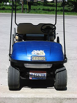
| 1996 to 1998 | Dark blue on gold gradient fade | The Heart of it All | ABC 1234 | AAA 0001 to ARZ 9999 | ||
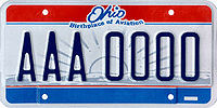
| 1998 to 2001 | Dark blue on gold gradient fade | Birthplace of Aviation | ABC 1234 | ASA 0001 to approximately BIF 9999, CAA 0001 to ? | ||
| 2001 to 2003 | Dark blue on reflective white with Ohio Bicentennial Commission logo and red and blue bars | Ohio Bicentennial Birthplace of Aviation |
AB12CD | AA10AA to EZ99ZZ | ||
 |
2004 to 2010 | Dark blue on reflective white with state seal ("Sunburst") graphic and red and blue bars | Birthplace of Aviation | ABC 1234 | DAA 1000 to EQZ 9999 ; EUJ 1000 to FAK 9999 (This gap was caused by the "Beautiful Ohio" plates that were already manufactured.) | |
| 2010 to present | Dark blue on rolling hills with farm, distant skyline, and airborne biplane Biplane A biplane is a fixed-wing aircraft with two superimposed main wings. The Wright brothers' Wright Flyer used a biplane design, as did most aircraft in the early years of aviation. While a biplane wing structure has a structural advantage, it produces more drag than a similar monoplane wing... |
Beautiful Ohio Birthplace of Aviation |
ABC 1234 | ERA 1000 to EUH 9999 ; FAL 1000 to ? (This gap was caused by the state's decision to not issue the "Beautiful Ohio" plates at the time of the recession.) | Available as a no-cost alternative to the concurrent "Sunburst" design from November 23, 2009 to 2010, when it became the primary design. Originally limited to 1.5 million plates. | |
Alternative passenger plates
| Image | Dates issued | Design | Slogan | Serial format | Serials issued | Notes |
|---|---|---|---|---|---|---|
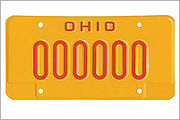 |
1967 to present | Red on yellow for DUI DUI DUI is a three letter acronym that may stand for:* Driving under the influence * Democratic Union for Integration — the largest ethnic Albanian party in the Republic of Macedonia* Data Use Identifier... offenders with limited driving privileges. Issued since 1967 but rarely used before the plate became mandated on all DUI offenders in 2004. |
none | 123456 1234567 |
Non-passenger plates
From the 1976 until 1996, license plates for pickup truckPickup truck
A pickup truck is a light motor vehicle with an open-top rear cargo area .-Definition:...
s and other light truck
Truck
A truck or lorry is a motor vehicle designed to transport cargo. Trucks vary greatly in size, power, and configuration, with the smallest being mechanically similar to an automobile...
-related vehicles (SUV
Sport utility vehicle
A sport utility vehicle is a generic marketing term for a vehicle similar to a station wagon, but built on a light-truck chassis. It is usually equipped with four-wheel drive for on- or off-road ability, and with some pretension or ability to be used as an off-road vehicle. Not all four-wheel...
s and conversion van
Conversion van
A Conversion van Is a full-size cargo van that is sent to third-party companies to be outfitted with various luxuries for road trips and camping.-History:...
s aside) were issued truck plates that said "Non Comm" (for "non-commercial
Truck classification
In the United States, commercial truck classification is determined based on the vehicle's gross vehicle weight rating . The classes range from 1-8...
truck") while semi-trucks
Semi-trailer truck
A semi-trailer truck, also known as a semi, tractor-trailer, or articulated truck or articulated lorry, is an articulated vehicle consisting of a towing engine , and a semi-trailer A semi-trailer truck, also known as a semi, tractor-trailer, or (in the United Kingdom and Ireland) articulated truck...
were issued plates that said "Commercial". Since 1996, however, the more consumer
Consumer
Consumer is a broad label for any individuals or households that use goods generated within the economy. The concept of a consumer occurs in different contexts, so that the usage and significance of the term may vary.-Economics and marketing:...
-oriented truck plates now say "Truck," instead of "Non-Comm."
Temporary tags
Vehicles purchased from a dealership are given a 30-Day Temporary Tag. The paper tag is filled out by hand. Since March 2001, it has featured a hologram.County coding
Ohio uses a numerical county-coding scheme to indicate the county of registration. The county code is displayed on stickers placed on the lower left corner of both the front and rear plates.The county number is the most visible, while the full county name is in small print below. The scheme assigns a number to each of the state's eighty-eight counties based on its position alphabetically. For example Adams County
Adams County, Ohio
As of the census of 2000, there were 27,330 people, 10,501 households, and 7,613 families residing in the county. The population density was 47 people per square mile . There were 11,822 housing units at an average density of 20 per square mile...
, the first alphabetically, is assigned the number 01, and Wyandot County
Wyandot County, Ohio
As of the census of 2000, there were 22,908 people, 8,882 households, and 6,270 families residing in the county. The population density was 56 people per square mile . There were 9,324 housing units at an average density of 23 per square mile...
, the last alphabetically, is assigned the number 88.
List of county numbers
- AdamsAdams County, OhioAs of the census of 2000, there were 27,330 people, 10,501 households, and 7,613 families residing in the county. The population density was 47 people per square mile . There were 11,822 housing units at an average density of 20 per square mile...
- AllenAllen County, OhioAllen County is a county located in the U.S. state of Ohio. Its population was 106,331 as of the 2010 census. It is included in the Lima, Ohio Metropolitan Statistical Area as well as the Lima–Van Wert–Wapakoneta Combined Statistical Area....
- AshlandAshland County, OhioAshland County is a county located in the state of Ohio, United States, and was formed in 1846 from parts of Huron, Lorain, Richland and Wayne Counties. As of the 2010 census, the population was 53,139. Its county seat is Ashland...
- AshtabulaAshtabula County, OhioAshtabula County is the northeasternmost county in the state of Ohio. As of 2010, the population was 101,497, its county seat is Jefferson. The county is named for a Native American word meaning "river of many fish"....
- AthensAthens County, OhioAs of the census of 2000, there were 62,223 people, 22,501 households, and 12,713 families residing in the county. The population density was 123 people per square mile . There were 24,901 housing units at an average density of 49 per square mile...
- AuglaizeAuglaize County, OhioAs of the census of 2000, there were 46,611 people, 17,376 households, and 12,771 families residing in the county. The population density was 116 people per square mile . There were 18,470 housing units at an average density of 46 per square mile...
- BelmontBelmont County, OhioBelmont County is a county located in the U.S. state of Ohio. It is part of the Wheeling, West Virginia Metropolitan Statistical Area. As of 2010, the population was 70,400. Its county seat is St. Clairsville...
- BrownBrown County, OhioAs of the census of 2000, there were 42,285 people, 15,555 households, and 11,790 families residing in the county. The population density was 86 people per square mile . There were 17,193 housing units at an average density of 35 per square mile...
- ButlerButler County, OhioButler County is a county located in the state of Ohio, United States. As of 2010, the population was 368,130. Its county seat is Hamilton. It is named for General Richard Butler, who died in 1791 fighting Indians in northern Ohio. Butler's army marched out of Fort Hamilton, where the city of...
- CarrollCarroll County, OhioCarroll County is a county located in the state of Ohio. As of 2010, the population was 28,836, no change from 2000. Its county seat is Carrollton. It is named for Charles Carroll of Carrollton, the last surviving signer of the Declaration of Independence....
- ChampaignChampaign County, OhioAs of the census of 2000, there were 38,890 people, 14,952 households, and 10,870 families residing in the county. The population density was 91 people per square mile . There were 15,890 housing units at an average density of 37 per square mile...
- ClarkClark County, OhioAs of the census of 2000, there were 144,742 people, 56,648 households, and 39,370 families residing in the county. The population density was 362 people per square mile . There were 61,056 housing units at an average density of 153 per square mile...
- ClermontClermont County, OhioClermont County is a county located in the state of Ohio, United States, just east of Cincinnati. As of 2010, the population was 197,363. Its county seat is Batavia...
- ClintonClinton County, OhioClinton County is a county located in the state of Ohio, United States. As of the 2010 census, the population was 42,040. The 2008 Census Population Estimate places the figure at 43,200. It is named for former U.S. Vice-President George Clinton...
- ColumbianaColumbiana County, OhioColumbiana County is a county located in the U.S. state of Ohio. As of 2010, the population was 107,841. It is named for Christopher Columbus and the county seat is Lisbon....
- CoshoctonCoshocton County, OhioCoshocton County is a county located in the state of Ohio, United States. As of the 2010 census, the population was 36,901. Its county seat is Coshocton. Its name comes from the Delaware Indian language and has been translated as "union of waters" or "black bear crossing".The Coshocton...
- CrawfordCrawford County, OhioCrawford County is a county located in the state of Ohio, United States. It was named for Colonel William Crawford, a soldier during the American Revolution....
- CuyahogaCuyahoga County, OhioCuyahoga County is a county located in the state of Ohio, United States. It is the most populous county in Ohio; as of the 2010 census, the population was 1,280,122. Its county seat is Cleveland. Cuyahoga County is part of Greater Cleveland, a metropolitan area, and Northeast Ohio, a...
- DarkeDarke County, OhioAs of the census of 2000, there were 53,309 people, 20,419 households, and 14,905 families residing in the county. The population density was 89 people per square mile . There were 21,583 housing units at an average density of 36 per square mile...
- DefianceDefiance County, OhioAs of the census of 2000, there were 39,500 people, 15,138 households, and 11,020 families residing in the county. The population density was 96 people per square mile . There were 16,040 housing units at an average density of 39 per square mile...
- DelawareDelaware County, OhioDelaware County is a fast-growing suburban county in the state of Ohio, United States, within the Columbus, Ohio Metropolitan Statistical Area. According to the United States Census Bureau's 2004 population estimates, Delaware County's population of 142,503 made it the fastest growing county in...
- ErieErie County, OhioAs of the census of 2000, there were 79,551 people, 31,727 households, and 21,764 families residing in the county. The population density was 312 people per square mile . There were 35,909 housing units at an average density of 141 per square mile...
- FairfieldFairfield County, OhioFairfield County is a county located in the state of Ohio, United States. As of 2010, the population was 146,156. Its county seat is Lancaster. Its name is a reference to the Fairfield area of the original Lancaster....
- FayetteFayette County, OhioAs of the census of 2000, there were 28,433 people, 11,054 households, and 7,837 families residing in the county. The population density was 70 people per square mile . There were 11,904 housing units at an average density of 29 per square mile...
- FranklinFranklin County, OhioFranklin County is a county located in the state of Ohio, United States. In 2010 the population was 1,163,414, making it the second largest county in Ohio and the 34th largest county in population in the United States. Franklin County is also the largest in the eight-county Columbus, Ohio...
- FultonFulton County, OhioFulton County is a county located in the U.S. state of Ohio. As of 2010, the population was 42,698. Its county seat is Wauseon. Fulton County is named for Robert Fulton, inventor of the steamboat....
- GalliaGallia County, OhioAs of the census of 2000, there were 31,069 people, 12,060 households, and 8,586 families residing in the county. The population density was 66 people per square mile . There were 13,498 housing units at an average density of 29 per square mile...
- GeaugaGeauga County, OhioGeauga County is a county located in the state of Ohio, United States. As of the 2010 census, the population was 93,389. It is named for a Native American word meaning "raccoon". The county seat is Chardon...
- GreeneGreene County, OhioGreene County is a county located in the state of Ohio, United States. The population was 161,573 in the 2010 Census. Its county seat is Xenia, and it was named for General Nathanael Greene, an officer in the Revolutionary War. Greene County was established on March 24, 1803.Greene County is part...
- GuernseyGuernsey County, OhioGuernsey County is a county located in the state of Ohio. As of 2010, the population was 40,087. Its county seat is Cambridge and is named for the Isle of Guernsey in the English Channel, from which many of the county's early settlers came....
- HamiltonHamilton County, OhioAs of 2000, there were 845,303 people, 346,790 households, and 212,582 families residing in the county. The population density was 2,075 people per square mile . There were 373,393 housing units at an average density of 917 per square mile...
- HancockHancock County, OhioHancock County is a county located in the state of Ohio, United States. As of the 2010 census, the population was 74,782. Its county seat is Findlay and was named for John Hancock, the first signer of the Declaration of Independence...
- HardinHardin County, OhioHardin County is a county located in the state of Ohio, United States. As of the 2010 census, the population was 32,058. Its county seat is Kenton and is named for John Hardin, an officer in the American Revolution.-Geography:According to the U.S...
- Harrison
- HenryHenry County, OhioHenry County is a county located in the state of Ohio, United States. As of the 2010 census, the population was 28,215. Its county seat is Napoleon and is named for Patrick Henry, the Virginian famous for his "give me liberty or give me death" speech....
- HighlandHighland County, OhioAs of the census of 2000, there were 40,875 people, 15,587 households, and 11,394 families residing in the county. The population density was 74 people per square mile . There were 17,583 housing units at an average density of 32 per square mile...
- HockingHocking County, OhioHocking County is a county located in the state of Ohio, United States. As of 2010, the population was 29,380. Its county seat is Logan. Its name is from the Hocking River, the origins of which are disputed but is said to be a Delaware Indian word meaning "bottle river".-Geography:According to the...
- HolmesHolmes County, OhioAs of the census of 2000, there were 38,943 people, 11,337 households, and 9,194 families residing in the county. The population density was 92 people per square mile . There were 12,280 housing units at an average density of 29 per square mile...
- HuronHuron County, OhioAs of the census of 2000, there were 59,487 people, 22,307 households, and 16,217 families residing in the county. The population density was 121 people per square mile . There were 23,594 housing units at an average density of 48 per square mile...
- JacksonJackson County, OhioJackson County is a county located in the state of Ohio, United States. As of 2010, the population was 33,225. Its county seat is Jackson and is named for Andrew Jackson, a hero of the War of 1812 who was subsequently elected President of the United States....
- JeffersonJefferson County, OhioJefferson County is a county located in the state of Ohio. As of 2010, the population was 69,709. Its county seat is Steubenville and is named for Thomas Jefferson, who was at the time Vice President....
- KnoxKnox County, OhioKnox County is a county located in the state of Ohio, United States. As of 2010, the population was 60,921. Its county seat is Mount Vernon and is named for Henry Knox, an officer in the American Revolutionary War who was later the first Secretary of War....
- LakeLake County, OhioLake County is a county located in the U.S. state of Ohio. As of 2010, the population was 230,041. The county seat is Painesville, and the county name comes from its location on the southern shore of Lake Erie....
- LawrenceLawrence County, OhioAs of the census of 2000, there were 62,319 people, 24,732 households, and 17,807 families residing in the county. The population density was 137 people per square mile . There were 27,189 housing units at an average density of 60 per square mile...
- LickingLicking County, OhioLicking County is a county located in the state of Ohio, United States. As of the 2010 census, the population was 166,492. Its county seat is Newark and is named for the salt licks that were in the area....
- LoganLogan County, OhioLogan County is a county in the state of Ohio, United States. As of the 2010 census, the population was 45,858. The county seat is Bellefontaine. The county is named for Benjamin Logan, who fought Native Americans in the area....
- LorainLorain County, OhioLorain County is a county located in the U.S. state of Ohio, and is considered to be a part of what is locally referred to as Greater Cleveland. As of the 2010 census, its population was 301,356. an increase from 284,664 in 2000...
- LucasLucas County, Ohio----...
- MadisonMadison County, OhioAs of the census of 2000, there were 40,213 people, 13,672 households, and 10,035 families residing in the county. The population density was 86 people per square mile . There were 14,399 housing units at an average density of 31 per square mile...
- Mahoning
- MarionMarion County, OhioMarion County is a county located in the state of Ohio, United States. As of the 2010 census, the population was 66,501. Its county seat is the city of Marion and is named for General Francis "The Swamp Fox" Marion, an officer in the Revolutionary War....
- Medina
- MeigsMeigs County, OhioMeigs County is a county located in the state of Ohio, United States. As of the 2010 census, the population was 23,770. Its county seat is Pomeroy, and it is named for Return J. Meigs, Jr., the 4th Governor of Ohio.-Geography:...
- MercerMercer County, OhioMercer County is a county located in the state of Ohio, United States. Its county seat is Celina and is named for Hugh Mercer, an officer in the American Revolutionary War.The Celina Micropolitan Statistical Area includes all of Mercer County.-Geography:...
- MiamiMiami County, OhioAs of the census of 2000, there were 98,868 people, 38,437 households, and 27,943 families residing in the county. The population density was 243 people per square mile . There were 40,554 housing units at an average density of 100 per square mile...
- MonroeMonroe County, OhioMonroe County is a county located in the state of Ohio. As of the 2010 census, the population was 14,642. Its county seat is Woodsfield and is named for James Monroe, Secretary of State when the county was formed and later President of the United States....
- MontgomeryMontgomery County, OhioMontgomery County is a county located in the state of Ohio, United States. The population was 535,153 in the 2010 Census. It was named in honor of Richard Montgomery, an American Revolutionary War general killed in 1775 while attempting to capture Quebec City, Canada. The county seat is Dayton...
- MorganMorgan County, Ohio**----...
- MorrowMorrow County, OhioMorrow County is a county located in the state of Ohio, United States. Shawnee people used the area for hunting purposes before white settlers arrived in the early 19th century. Morrow County was organized in 1848 from parts of four neighboring counties and named for Jeremiah Morrow, Governor of...
- MuskingumMuskingum County, OhioMuskingum County is a county located in the state of Ohio, United States. As of the 2010 census, the population was 86,074. Its county seat is Zanesville...
- NobleNoble County, OhioNoble County is a county located in the state of Ohio. As of the 2010 census, the population was 14,645. Its county seat is Caldwell. Noble County is named for Rep. Warren P. Noble of the Ohio House of Representatives, who was an early settler there.-History:...
- OttawaOttawa County, OhioOttawa County is a county located in the state of Ohio, United States. As of the 2010 census, the population was 41,428. Its county seat is Port Clinton and is named either for the Ottawa Indians who lived there, or for an Indian word meaning "trader"....
- PauldingPaulding County, OhioAs of the census of 2000, there were 20,293 people, 7,773 households, and 5,689 families residing in the county. The population density was 49 people per square mile . There were 8,478 housing units at an average density of 20 per square mile...
- PerryPerry County, OhioPerry County is a county located in the state of Ohio, United States. Founded on March 1, 1818, it was the 55th county to be formed in Ohio. Portions of Fairfield, Washington and Muskingum Counties were taken to create Perry County. As of the 2010 census, the population was 36,058. Its county seat...
- PickawayPickaway County, OhioAs of the census of 2000, there were 52,727 people, 17,599 households, and 13,287 families residing in the county. The population density was 105 people per square mile . There were 18,596 housing units at an average density of 37 per square mile...
- PikePike County, OhioAs of the census of 2000, there were 27,695 people, 10,444 households, and 7,665 families residing in the county. The population density was 63 people per square mile . There were 11,602 housing units at an average density of 26 per square mile...
- PortagePortage County, OhioPortage County is a county located in the U.S. state of Ohio. The population was 152,061 at the 2000 Census and 161,419 at the 2010 Census. Its county seat is Ravenna. Portage County is named for the portage between the Cuyahoga and Tuscarawas Rivers...
- PreblePreble County, OhioAs of the census of 2000, there were 42,337 people, 16,001 households, and 12,144 families residing in the county. The population density was 100 people per square mile . There were 17,186 housing units at an average density of 40 per square mile...
- PutnamPutnam County, OhioPutnam County is a county located in the state of Ohio, United States. As of the 2010 census, the population was 34,499. The name is in honor of Israel Putnam, who was a hero in the French and Indian War and a general in the American Revolutionary War. Its county seat is...
- RichlandRichland County, OhioRichland County is a county located in the state of Ohio, United States. As of the 2010 census, the population was 124,475. It is included in the Mansfield, Ohio, Metropolitan Statistical Area as well as the Mansfield–Bucyrus Combined Statistical Area....
- RossRoss County, OhioAs of the census of 2000, there were 73,345 people, 27,136 households, and 19,185 families residing in the county. The population density was 106 people per square mile . There were 29,461 housing units at an average density of 43 per square mile...
- SanduskySandusky County, OhioSandusky County is a county in the U.S. state of Ohio. As of the 2010 census, the population was 60,944. Its county seat is Fremont and it is named for a native word meaning "water" ....
- SciotoScioto County, OhioAs of the census of 2000, there were 79,195 people, 30,871 households, and 21,362 families residing in the county. The population density was 129 people per square mile . There were 34,054 housing units at an average density of 56 per square mile...
- SenecaSeneca County, OhioSeneca County is a county located in the state of Ohio, United States. As of the 2010 census, the population was 56,745. Its county seat is Tiffin and it is named for the Seneca Indians.The Tiffin Micropolitan Statistical Area includes all of Seneca County....
- ShelbyShelby County, OhioAs of the census of 2000, there were 47,910 people, 17,636 households, and 13,085 families residing in the county. The population density was 117 people per square mile . There were 18,682 housing units at an average density of 46 per square mile...
- StarkStark County, OhioStark County is a county located in the U.S. state of Ohio. As of the 2010 census, the population was 375,586. It is included in the Canton-Massillon, Ohio Metropolitan Statistical Area....
- SummitSummit County, OhioSummit County is an urban county located in the state of Ohio, United States. As of the 2000 census, the population was 542,899. In the 2010 Census the population was 541,781. Its county seat is Akron...
- TrumbullTrumbull County, OhioAs of the census of 2000, there were 225,116 people, 89,020 households, and 61,690 families residing in the county. The population density was 365 people per square mile . There were 95,117 housing units at an average density of 154 per square mile...
- TuscarawasTuscarawas County, OhioTuscarawas County is a county located in the eastern part of the state of Ohio. As of the 2010 census, the population was 92,582. Its county seat is New Philadelphia...
- UnionUnion County, OhioUnion County is a county located in the US state of Ohio. As of the 2010 census, the population was 52,300. Increasingly becoming more of a suburban county, the population was estimated at 47,234 in 2007 by the U.S. Census Bureau...
- Van Wert
- VintonVinton County, OhioVinton County is a county located in the state of Ohio, United States. As of the 2010 census, the population was 13,435. , the least populous in the state. Its county seat is McArthur. The county is named for Samuel Finley Vinton, a 19th-century United States Congressman from...
- WarrenWarren County, OhioWarren County is a county located in the state of Ohio, United States. The population was 212,693 at the 2010 census. Its county seat is Lebanon. Warren County was erected May 1, 1803, from Hamilton County, and named for Dr...
- WashingtonWashington County, OhioWashington County is a county located in the state of Ohio. As of the 2010 census, the population was 61,778. Its county seat is Marietta. The county, the oldest in the state, is named for George Washington. Washington County is included in the Parkersburg-Marietta-Vienna, West Virginia-Ohio...
- WayneWayne County, OhioWayne County is a county located in the state of Ohio, United States, and is named for General "Mad" Anthony Wayne. As of the 2010 census, the population was 114,520. Its county seat is Wooster....
- WilliamsWilliams County, OhioWilliams County is a county located in the U.S. state of Ohio. As of 2010, the population was 37,642. Its county seat is Bryan and is named for David Williams, one of the captors of John André in the American Revolutionary War.-Geography:According to the U.S...
- WoodWood County, OhioWood County is a county located in the state of Ohio, United States. As of the 2010 census, the population was 125,488. Its county seat is Bowling Green. The county was named for Captain Eleazer D. Wood, the engineer for General William Henry Harrison's army, who built Fort Meigs in the War of 1812...
- WyandotWyandot County, OhioAs of the census of 2000, there were 22,908 people, 8,882 households, and 6,270 families residing in the county. The population density was 56 people per square mile . There were 9,324 housing units at an average density of 23 per square mile...
Reserved series
On recent seven-character baseplates, the state has reserved certain letter series to be issued in coordination with specific car dealershipCar dealership
A car dealership or vehicle local distribution is a business that sells new or used cars at the retail level, based on a dealership contract with an automaker or its sales subsidiary. It employs automobile salespeople to do the selling...
s or leasing agencies.
|