
Cuyahoga County, Ohio
Encyclopedia
Cuyahoga County is a county located in the state
of Ohio
, United States
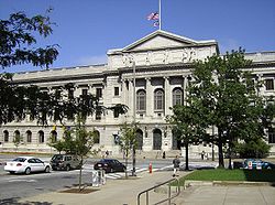
. It is the most populous county in Ohio; as of the 2010 census, the population was 1,280,122. Its county seat
is Cleveland. Cuyahoga County is part of Greater Cleveland
, a metropolitan area
, and Northeast Ohio, a thirteen-county region, joined together in economic development initiatives. The county is named after the Native American
word (possibly Algonquian
) Cuyahoga, which means "crooked river". The name is also assigned to the Cuyahoga River
, which bisects the county. Former U.S. President
James A. Garfield was born in what was Cuyahoga County's Orange Township
.
, Lake
, and Lorain
Counties. It was named after the Cuyahoga River.
, the county has a total area of 1246 square miles (3,227.1 km²).458 square miles (1,186.2 km²) is land and 787 square miles (2,038.3 km²) (63.19%) is water. A portion of Cuyahoga Valley National Park
is located in the southeastern portion of the county.
 As of the census
of 2000, there were 1,393,978 people, 571,457 households, and 354,874 families residing in the county. The population density
was 3,040 people per square mile (1,174/km²). There were 616,903 housing units at an average density of 1,346 per square mile (520/km²). The racial makeup of the county was 67.35% White
, 27.45% African American
, 0.18% Native American
, 1.81% Asian
, 0.02% Pacific Islander
, 1.50% from other races
, and 1.68% from two or more races. 3.38% of the population were Hispanic
or Latino
of any race. 12.3% were of German
, 9.1% Irish
, 8.7% Italian
and 7.3% Polish ancestry according to Census 2000. 89.0% spoke English
and 3.2% Spanish
as their first language.
There were 571,457 households out of which 28.50% had children under the age of 18 living with them, 42.40% were married couples
living together, 15.70% had a female householder with no husband present, and 37.90% were non-families. 32.80% of all households were made up of individuals and 12.10% had someone living alone who was 65 years of age or older. The average household size was 2.39 and the average family size was 3.06.
In the county the population was spread out with 25.00% under the age of 18, 8.00% from 18 to 24, 29.30% from 25 to 44, 22.20% from 45 to 64, and 15.60% who were 65 years of age or older. The median age was 37 years. For every 100 females there were 89.50 males. For every 100 females age 18 and over, there were 85.20 males.
The median income for a household in the county was $39,168, and the median income for a family was $49,559. Males had a median income of $39,603 versus $28,395 for females. The per capita income
for the county was $22,272. About 10.30% of families and 13.10% of the population were below the poverty line, including 19.40% of those under age 18 and 9.30% of those age 65 or over.
Cuyahoga County had long been led by a three-member Board of County Commissioners
. However, on November 3, 2009, county voters overwhelmingly approved the adoption of a county charter form of government, which replaced the three-commissioner form of county government with an elected county executive
and an 11-member county council
. Each council member represents a single district; there are no at-large
districts. Summit County
is the only other Ohio county with this form of government.
In the November 2, 2010 election, Lakewood
mayor Ed FitzGerald defeated Matt Dolan
to become the first Cuyahoga County executive. The first Cuyahoga County Council
was also elected, with Democrats
winning the majority (8-3) over the Republicans
.
Fairview Park
Garfield Heights
Highland Heights
Independence
Lakewood
Lyndhurst
Maple Heights
Mayfield Heights
Middleburg Heights
North Olmsted
North Royalton
Olmsted Falls
Parma
Parma Heights
Pepper Pike
Richmond Heights
Rocky River
Seven Hills
Shaker Heights
Solon
South Euclid
Strongsville
University Heights
Warrensville Heights
Westlake
Highland Hills
Hunting Valley
Linndale
Mayfield
Moreland Hills
Newburgh Heights
North Randall
Oakwood
Orange
Valley View
Walton Hills
Woodmere
system. Its 16 reservations provide more than 21000 acres (8,498.4 ha) of green space and recreational amenities. The county is home to part of Cuyahoga Valley National Park
, which extends southward into Summit County
.
U.S. state
A U.S. state is any one of the 50 federated states of the United States of America that share sovereignty with the federal government. Because of this shared sovereignty, an American is a citizen both of the federal entity and of his or her state of domicile. Four states use the official title of...
of Ohio
Ohio
Ohio is a Midwestern state in the United States. The 34th largest state by area in the U.S.,it is the 7th‑most populous with over 11.5 million residents, containing several major American cities and seven metropolitan areas with populations of 500,000 or more.The state's capital is Columbus...
, United States
United States
The United States of America is a federal constitutional republic comprising fifty states and a federal district...
. It is the most populous county in Ohio; as of the 2010 census, the population was 1,280,122. Its county seat
County seat
A county seat is an administrative center, or seat of government, for a county or civil parish. The term is primarily used in the United States....
is Cleveland. Cuyahoga County is part of Greater Cleveland
Greater Cleveland
Greater Cleveland is a nickname for the metropolitan area surrounding Cleveland, Ohio and is part of what used to be the Connecticut Western Reserve.Northeast Ohio refers to a similar but substantially larger area as described below...
, a metropolitan area
Metropolitan area
The term metropolitan area refers to a region consisting of a densely populated urban core and its less-populated surrounding territories, sharing industry, infrastructure, and housing. A metropolitan area usually encompasses multiple jurisdictions and municipalities: neighborhoods, townships,...
, and Northeast Ohio, a thirteen-county region, joined together in economic development initiatives. The county is named after the Native American
Native Americans in the United States
Native Americans in the United States are the indigenous peoples in North America within the boundaries of the present-day continental United States, parts of Alaska, and the island state of Hawaii. They are composed of numerous, distinct tribes, states, and ethnic groups, many of which survive as...
word (possibly Algonquian
Algonquian languages
The Algonquian languages also Algonkian) are a subfamily of Native American languages which includes most of the languages in the Algic language family. The name of the Algonquian language family is distinguished from the orthographically similar Algonquin dialect of the Ojibwe language, which is a...
) Cuyahoga, which means "crooked river". The name is also assigned to the Cuyahoga River
Cuyahoga River
The Cuyahoga River is located in Northeast Ohio in the United States. Outside of Ohio, the river is most famous for being "the river that caught fire", helping to spur the environmental movement in the late 1960s...
, which bisects the county. Former U.S. President
President of the United States
The President of the United States of America is the head of state and head of government of the United States. The president leads the executive branch of the federal government and is the commander-in-chief of the United States Armed Forces....
James A. Garfield was born in what was Cuyahoga County's Orange Township
Orange, Ohio
Orange is a village in Cuyahoga County, Ohio, United States. It is an affluent suburb of Cleveland. The population was 3,323 at the 2010 census.-History:...
.
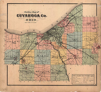
History
Cuyahoga County was organized on June 7, 1807. It was later reduced by the creation of HuronHuron County, Ohio
As of the census of 2000, there were 59,487 people, 22,307 households, and 16,217 families residing in the county. The population density was 121 people per square mile . There were 23,594 housing units at an average density of 48 per square mile...
, Lake
Lake County, Ohio
Lake County is a county located in the U.S. state of Ohio. As of 2010, the population was 230,041. The county seat is Painesville, and the county name comes from its location on the southern shore of Lake Erie....
, and Lorain
Lorain County, Ohio
Lorain County is a county located in the U.S. state of Ohio, and is considered to be a part of what is locally referred to as Greater Cleveland. As of the 2010 census, its population was 301,356. an increase from 284,664 in 2000...
Counties. It was named after the Cuyahoga River.
Geography
According to the U.S. Census BureauUnited States Census Bureau
The United States Census Bureau is the government agency that is responsible for the United States Census. It also gathers other national demographic and economic data...
, the county has a total area of 1246 square miles (3,227.1 km²).458 square miles (1,186.2 km²) is land and 787 square miles (2,038.3 km²) (63.19%) is water. A portion of Cuyahoga Valley National Park
Cuyahoga Valley National Park
Cuyahoga Valley National Park preserves and reclaims the rural landscape along the Cuyahoga River between Akron and Cleveland in Northeast Ohio. The park is the only national park in Ohio.Cuyahoga means "crooked river" in Mohawk....
is located in the southeastern portion of the county.
Major highways
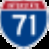
 Interstate 71Interstate 71Interstate 71 is an Interstate Highway in the Great Lakes/Midwestern and Southeastern region of the United States. Its southern terminus is at an interchange with Interstate 64 and Interstate 65 in Louisville, Kentucky. Its northern terminus is at an interchange with Interstate 90 in Cleveland,...
 Interstate 271Interstate 271Interstate 271 is an auxiliary interstate highway in the suburbs of Cleveland and Akron in the U.S. state of Ohio. The highway is officially designated the "Cleveland Outerbelt East", but rarely referred to by that name.-Route description:...
 Interstate 77Interstate 77 in OhioInterstate 77 is an Interstate Highway in the eastern United States. It traverses diverse terrain, from the mountainous state of West Virginia to the rolling farmlands of North Carolina and Ohio. It largely supplants the old U.S. Route 21 between Cleveland, Ohio, and Columbia, South Carolina, as...
 Interstate 80
 Interstate 480Interstate 480 (Ohio)Interstate 480 is a loop highway that connects the Ohio Turnpike with suburban Cleveland, Ohio. The highway is officially designated the Outerbelt South Freeway, but it is rarely referred to by that name....
 Interstate 90Interstate 90 in OhioIn the U.S. state of Ohio, Interstate 90 runs east–west across the northern tier. Much of it is along the Ohio Turnpike, but sections outside the turnpike pass through Cleveland and northeast into Pennsylvania.-Route description:...
 Interstate 490Interstate 490 (Ohio)Interstate 490 is a Interstate Highway in Cleveland, Ohio. The western terminus is a junction with I-90 and I-71 on Cleveland's west side. After spanning the Cuyahoga River, the eastern terminus is a junction with East 55th Street, just east of I-77....
 U.S. Route 6U.S. Route 6U.S. Route 6 , also called the Grand Army of the Republic Highway, a name that honors an American Civil War veterans association, is a main route of the U.S. Highway system, running east-northeast from Bishop, California to Provincetown, Massachusetts. Until 1964, it continued south from Bishop to...
 U.S. Route 20U.S. Route 20U.S. Route 20 is an east–west United States highway. As the "0" in its route number implies, US 20 is a coast-to-coast route. Spanning , it is the longest road in the United States, and the route sparsely parallels Interstate 90...
 U.S. Route 42U.S. Route 42U.S. Route 42 is an east–west United States highway that runs northeast-southwest for 355 miles from Cleveland, Ohio to Louisville, Kentucky. The route has several names including Pearl Road from Cleveland to Medina in Northeast Ohio, the Cincinnati and Lebanon Pike in southwestern Ohio and...
 U.S. Route 322U.S. Route 322U.S. Route 322 is a long, east–west United States Highway, traversing Ohio, Pennsylvania, and New Jersey. The road is a spur of U.S. Route 22 and one of the original highways from 1926...
 U.S. Route 422U.S. Route 422U.S. Route 422 is a long spur route of US 22 split into two segments in the U.S. states of Ohio and Pennsylvania. The western spur begins in downtown Cleveland, Ohio, and ends at Ebensburg, Pennsylvania...
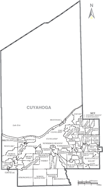
Adjacent counties
- Across Lake ErieLake ErieLake Erie is the fourth largest lake of the five Great Lakes in North America, and the tenth largest globally. It is the southernmost, shallowest, and smallest by volume of the Great Lakes and therefore also has the shortest average water residence time. It is bounded on the north by the...
lies Chatham-Kent and Elgin CountyElgin County, OntarioElgin County is a county and census division of the Canadian province of Ontario with a current population of approximately 46,000. The county seat is St. Thomas.It consists of:*Town of Aylmer*Municipality of Bayham*Municipality of Central Elgin...
, OntarioOntarioOntario is a province of Canada, located in east-central Canada. It is Canada's most populous province and second largest in total area. It is home to the nation's most populous city, Toronto, and the nation's capital, Ottawa....
, CanadaCanadaCanada is a North American country consisting of ten provinces and three territories. Located in the northern part of the continent, it extends from the Atlantic Ocean in the east to the Pacific Ocean in the west, and northward into the Arctic Ocean...
(north) - Lake CountyLake County, OhioLake County is a county located in the U.S. state of Ohio. As of 2010, the population was 230,041. The county seat is Painesville, and the county name comes from its location on the southern shore of Lake Erie....
(northeast) - Geauga CountyGeauga County, OhioGeauga County is a county located in the state of Ohio, United States. As of the 2010 census, the population was 93,389. It is named for a Native American word meaning "raccoon". The county seat is Chardon...
(east) - Summit CountySummit County, OhioSummit County is an urban county located in the state of Ohio, United States. As of the 2000 census, the population was 542,899. In the 2010 Census the population was 541,781. Its county seat is Akron...
(southeast) - Medina County (southwest)
- Lorain CountyLorain County, OhioLorain County is a county located in the U.S. state of Ohio, and is considered to be a part of what is locally referred to as Greater Cleveland. As of the 2010 census, its population was 301,356. an increase from 284,664 in 2000...
(west) - Portage CountyPortage County, OhioPortage County is a county located in the U.S. state of Ohio. The population was 152,061 at the 2000 Census and 161,419 at the 2010 Census. Its county seat is Ravenna. Portage County is named for the portage between the Cuyahoga and Tuscarawas Rivers...
(southeast corner)
Demographics
Census
A census is the procedure of systematically acquiring and recording information about the members of a given population. It is a regularly occurring and official count of a particular population. The term is used mostly in connection with national population and housing censuses; other common...
of 2000, there were 1,393,978 people, 571,457 households, and 354,874 families residing in the county. The population density
Population density
Population density is a measurement of population per unit area or unit volume. It is frequently applied to living organisms, and particularly to humans...
was 3,040 people per square mile (1,174/km²). There were 616,903 housing units at an average density of 1,346 per square mile (520/km²). The racial makeup of the county was 67.35% White
Race (United States Census)
Race and ethnicity in the United States Census, as defined by the Federal Office of Management and Budget and the United States Census Bureau, are self-identification data items in which residents choose the race or races with which they most closely identify, and indicate whether or not they are...
, 27.45% African American
Race (United States Census)
Race and ethnicity in the United States Census, as defined by the Federal Office of Management and Budget and the United States Census Bureau, are self-identification data items in which residents choose the race or races with which they most closely identify, and indicate whether or not they are...
, 0.18% Native American
Race (United States Census)
Race and ethnicity in the United States Census, as defined by the Federal Office of Management and Budget and the United States Census Bureau, are self-identification data items in which residents choose the race or races with which they most closely identify, and indicate whether or not they are...
, 1.81% Asian
Race (United States Census)
Race and ethnicity in the United States Census, as defined by the Federal Office of Management and Budget and the United States Census Bureau, are self-identification data items in which residents choose the race or races with which they most closely identify, and indicate whether or not they are...
, 0.02% Pacific Islander
Race (United States Census)
Race and ethnicity in the United States Census, as defined by the Federal Office of Management and Budget and the United States Census Bureau, are self-identification data items in which residents choose the race or races with which they most closely identify, and indicate whether or not they are...
, 1.50% from other races
Race (United States Census)
Race and ethnicity in the United States Census, as defined by the Federal Office of Management and Budget and the United States Census Bureau, are self-identification data items in which residents choose the race or races with which they most closely identify, and indicate whether or not they are...
, and 1.68% from two or more races. 3.38% of the population were Hispanic
Race (United States Census)
Race and ethnicity in the United States Census, as defined by the Federal Office of Management and Budget and the United States Census Bureau, are self-identification data items in which residents choose the race or races with which they most closely identify, and indicate whether or not they are...
or Latino
Race (United States Census)
Race and ethnicity in the United States Census, as defined by the Federal Office of Management and Budget and the United States Census Bureau, are self-identification data items in which residents choose the race or races with which they most closely identify, and indicate whether or not they are...
of any race. 12.3% were of German
Germans
The Germans are a Germanic ethnic group native to Central Europe. The English term Germans has referred to the German-speaking population of the Holy Roman Empire since the Late Middle Ages....
, 9.1% Irish
Irish people
The Irish people are an ethnic group who originate in Ireland, an island in northwestern Europe. Ireland has been populated for around 9,000 years , with the Irish people's earliest ancestors recorded having legends of being descended from groups such as the Nemedians, Fomorians, Fir Bolg, Tuatha...
, 8.7% Italian
Italian people
The Italian people are an ethnic group that share a common Italian culture, ancestry and speak the Italian language as a mother tongue. Within Italy, Italians are defined by citizenship, regardless of ancestry or country of residence , and are distinguished from people...
and 7.3% Polish ancestry according to Census 2000. 89.0% spoke English
English language
English is a West Germanic language that arose in the Anglo-Saxon kingdoms of England and spread into what was to become south-east Scotland under the influence of the Anglian medieval kingdom of Northumbria...
and 3.2% Spanish
Spanish language
Spanish , also known as Castilian , is a Romance language in the Ibero-Romance group that evolved from several languages and dialects in central-northern Iberia around the 9th century and gradually spread with the expansion of the Kingdom of Castile into central and southern Iberia during the...
as their first language.
There were 571,457 households out of which 28.50% had children under the age of 18 living with them, 42.40% were married couples
Marriage
Marriage is a social union or legal contract between people that creates kinship. It is an institution in which interpersonal relationships, usually intimate and sexual, are acknowledged in a variety of ways, depending on the culture or subculture in which it is found...
living together, 15.70% had a female householder with no husband present, and 37.90% were non-families. 32.80% of all households were made up of individuals and 12.10% had someone living alone who was 65 years of age or older. The average household size was 2.39 and the average family size was 3.06.
In the county the population was spread out with 25.00% under the age of 18, 8.00% from 18 to 24, 29.30% from 25 to 44, 22.20% from 45 to 64, and 15.60% who were 65 years of age or older. The median age was 37 years. For every 100 females there were 89.50 males. For every 100 females age 18 and over, there were 85.20 males.
The median income for a household in the county was $39,168, and the median income for a family was $49,559. Males had a median income of $39,603 versus $28,395 for females. The per capita income
Per capita income
Per capita income or income per person is a measure of mean income within an economic aggregate, such as a country or city. It is calculated by taking a measure of all sources of income in the aggregate and dividing it by the total population...
for the county was $22,272. About 10.30% of families and 13.10% of the population were below the poverty line, including 19.40% of those under age 18 and 9.30% of those age 65 or over.
Government
Cuyahoga County had long been led by a three-member Board of County Commissioners
County commission
A county commission is a group of elected officials charged with administering the county government in local government in some states of the United States. County commissions are usually made up of three or more individuals...
. However, on November 3, 2009, county voters overwhelmingly approved the adoption of a county charter form of government, which replaced the three-commissioner form of county government with an elected county executive
County executive
A county executive is the head of the executive branch of government in a county. This position is common in the United States.The executive may be an elected or an appointed position...
and an 11-member county council
County council
A county council is the elected administrative body governing an area known as a county. This term has slightly different meanings in different countries.-United Kingdom:...
. Each council member represents a single district; there are no at-large
At-Large
At-large is a designation for representative members of a governing body who are elected or appointed to represent the whole membership of the body , rather than a subset of that membership...
districts. Summit County
Summit County, Ohio
Summit County is an urban county located in the state of Ohio, United States. As of the 2000 census, the population was 542,899. In the 2010 Census the population was 541,781. Its county seat is Akron...
is the only other Ohio county with this form of government.
In the November 2, 2010 election, Lakewood
Lakewood, Ohio
Lakewood is a city in Cuyahoga County, Ohio, United States. It is part of the Greater Cleveland Metropolitan Area, and borders the city of Cleveland. The population was 52,131 at the 2010 making it the third largest city in Cuyahoga County, behind Cleveland and Parma .Lakewood, one of Cleveland's...
mayor Ed FitzGerald defeated Matt Dolan
Matt Dolan
Matthew J. Dolan is a former member of the Ohio House of Representatives, representing the 98th District from 2005 to 2010. He resigned in January 2010 to focus on a run for Cuyahoga County Executive...
to become the first Cuyahoga County executive. The first Cuyahoga County Council
Cuyahoga County Council
Cuyahoga County Council is the legislative branch of the government of Cuyahoga County in Ohio. Cuyahoga is one of only two of Ohio's 88 counties not governed by a three-member commission...
was also elected, with Democrats
Democratic Party (United States)
The Democratic Party is one of two major contemporary political parties in the United States, along with the Republican Party. The party's socially liberal and progressive platform is largely considered center-left in the U.S. political spectrum. The party has the lengthiest record of continuous...
winning the majority (8-3) over the Republicans
Republican Party (United States)
The Republican Party is one of the two major contemporary political parties in the United States, along with the Democratic Party. Founded by anti-slavery expansion activists in 1854, it is often called the GOP . The party's platform generally reflects American conservatism in the U.S...
.
Politics
Cuyahoga County is heavily Democratic in voter registration.| Year | Democrat Democratic Party (United States) The Democratic Party is one of two major contemporary political parties in the United States, along with the Republican Party. The party's socially liberal and progressive platform is largely considered center-left in the U.S. political spectrum. The party has the lengthiest record of continuous... |
Republican Republican Party (United States) The Republican Party is one of the two major contemporary political parties in the United States, along with the Democratic Party. Founded by anti-slavery expansion activists in 1854, it is often called the GOP . The party's platform generally reflects American conservatism in the U.S... |
|---|---|---|
| 2008 | 68.50% 441,836 | 30.44% 196,369 |
| 2004 | 66.57% 448,503 | 32.89% 221,600 |
| 2000 | 62.62% 359,913 | 33.42% 192,099 |
| 1996 | 60.75% 341,357 | 29.15% 163,770 |
| 1992 | 52.72% 337,548 | 29.24% 187,186 |
| 1988 | 58.79% 353,401 | 40.33% 242,439 |
| 1984 | 55.65% 362,626 | 43.60% 284,094 |
| 1980 | 50.02% 307,448 | 41.47% 254,883 |
| 1976 | 56.03% 349,186 | 41.01% 255,594 |
| 1972 | 48.15% 317,670 | 49.94% 329,493 |
| 1968 | 53.95% 363,540 | 35.44% 238,791 |
| 1964 | 71.50% 492,911 | 28.50% 196,436 |
| 1960 | 59.83% 429,030 | 40.17% 288,056 |
Communities
Cities
>- Bay VillageBay Village, Ohio-Education:Bay High School was awarded the blue ribbon award in the school year of 2010-11.Newsweek magazine placed Bay High School 793rd in its 2009 ranking of the top 1,500 U.S...
- BeachwoodBeachwood, Ohio-External links:* *...
- BedfordBedford, OhioBedford is a city in Cuyahoga County, Ohio, United States. The population was 13,074 at the 2010 census. It is an eastern suburb of Cleveland.-Geography:Bedford is located at ....
- Bedford HeightsBedford Heights, Ohio-External links:*...
- BereaBerea, Ohio- History :The first European settlers were originally from Connecticut. Berea fell within Connecticut's Western Reserve and was surveyed and divided into townships and ranges by one Gideon Granger, a gentleman who served as Postmaster General under President Thomas Jefferson...
- BrecksvilleBrecksville, Ohio-External links:* * *...
- Broadview HeightsBroadview Heights, OhioAs of the census of 2000, there were 15,967 people, 6,411 households, and 4,378 families residing in the city. The population density was 1,222.7 people per square mile . There were 6,803 housing units at an average density of 521.0 per square mile...
- Brook ParkBrook Park, Ohio-External links:*...
- BrooklynBrooklyn, OhioBrooklyn is a city in Cuyahoga County, Ohio, United States. The population was 11,169 at the 2010 census.-Geography:Brooklyn is located at ....
- ClevelandCleveland, OhioCleveland is a city in the U.S. state of Ohio and is the county seat of Cuyahoga County, the most populous county in the state. The city is located in northeastern Ohio on the southern shore of Lake Erie, approximately west of the Pennsylvania border...
- Cleveland HeightsCleveland Heights, OhioCleveland Heights is a city in Cuyahoga County, Ohio, United States, a suburb of Cleveland. The city's population was 46,121 at the 2010 census.-Geography:Cleveland Heights is located at ....
- East ClevelandEast Cleveland, OhioEast Cleveland is a city in Cuyahoga County, Ohio, United States, and is the first suburb of Cleveland, Ohio. The population was 17,843 at the 2010 census....
- EuclidEuclid, OhioEuclid is a city in Cuyahoga County, Ohio, United States. It is part of the Greater Cleveland Metropolitan Area, and borders Cleveland. As of the 2010 census, the city had a total population of 48,920...
Fairview Park, Ohio
-Demographics:As of the census of 2000, there were 420,690 people, 7,856 households, and 4,713 families residing in the city. The population density was 3,742.2 people per square mile . There were 8,152 housing units at an average density of 1,736.1 per square mile...
Garfield Heights, Ohio
Garfield Heights is a city in Cuyahoga County, Ohio, United States. The population was 28,849 at the time of the 2010 census.-Geography:Garfield Heights is located at ....
Highland Heights, Ohio
-External links:*...
Independence, Ohio
Independence is a city in Cuyahoga County, Ohio, in the United States. As of the 2010 census, the city population was 7,133.-Geography:Independence is located at .According to the United States Census Bureau, the city has a total area of , all of it land....
Lakewood, Ohio
Lakewood is a city in Cuyahoga County, Ohio, United States. It is part of the Greater Cleveland Metropolitan Area, and borders the city of Cleveland. The population was 52,131 at the 2010 making it the third largest city in Cuyahoga County, behind Cleveland and Parma .Lakewood, one of Cleveland's...
Lyndhurst, Ohio
As of the census of 2000, there were 15,279 people, 6,642 households, and 4,397 families residing in the city. The population density was 3,480.1 people per square mile . There were 6,855 housing units at an average density of 1,561.4 per square mile...
Maple Heights, Ohio
As of the census of 2000, there were 26,156 people, 10,489 households, and 6,964 families residing in the city. The population density was 5,039.1 people per square mile . There were 10,935 housing units at an average density of 2,106.7 per square mile...
Mayfield Heights, Ohio
-External links:*...
Middleburg Heights, Ohio
-History:The first European settlers to the area that became Middleburg Township, Ohio were originally from Waterbury, Connecticut.-External links:* * and from The Encyclopedia of Cleveland History...
North Olmsted, Ohio
-Business:Moen Incorporated, a fixture and faucet company, is headquartered in North Olmsted. CommutAir, a regional airline, has its operations center in North Olmsted....
North Royalton, Ohio
As of the census of 2000, there were 28,647 people, 11,250 households, and 7,695 families residing in the city. The population density was 1,345.9 people per square mile . There were 11,754 housing units at an average density of 552.2 per square mile...
Olmsted Falls, Ohio
-External links:***...
Parma, Ohio
Parma is a city in Cuyahoga County, Ohio, United States. It is the largest suburb of Cleveland and the seventh largest city in the state of Ohio...
Parma Heights, Ohio
There are seven council members serving at large. Every two years there is an election. Four positions are open. The top three candidates are each elected for a four-year term. The fourth candidate is awarded a two-year term.[Effective January 2008]...
Richmond Heights, Ohio
-External links:*...
Rocky River, Ohio
Rocky River is an affluent western suburb of Cleveland, Ohio, United States located in Cuyahoga County approximately nine miles west of Public Square in downtown Cleveland. The city is named for the river that forms its eastern border...
Seven Hills, Ohio
Seven Hills is a city in Cuyahoga County, Ohio, United States. The population was 11,804 at the 2010 census.-Geography:Seven Hills is located at .According to the United States Census Bureau, the city has a total area of , all land....
Shaker Heights, Ohio
Shaker Heights is a city in Cuyahoga County, Ohio, United States. As of the 2010 Census, the city population was 28,448. It is an inner-ring streetcar suburb of Cleveland that abuts the city on its eastern side.-Topography:Shaker Heights is located at...
Solon, Ohio
Solon is a city in Cuyahoga County, Ohio, and is an affluent suburb of Cleveland in the Northeast Ohio Region, the 14th largest Combined Statistical Area in the United States. As of the 2010 census, the city population was 23,348...
South Euclid, Ohio
South Euclid is a city in Cuyahoga County, Ohio, United States. It is an inner-ring suburb of Cleveland.-Geography:Acting almost as a central point for the east side of Cleveland, South Euclid is bordered by Cleveland, Cleveland Heights, University Heights, Beachwood, Lyndhurst, Richmond Heights,...
Strongsville, Ohio
As of the census of 2000, there were 43,858 people, 16,209 households, and 12,383 families residing in the city. The population density was 1,779.6 people per square mile . There were 16,863 housing units at an average density of 684.2 per square mile...
University Heights, Ohio
University Heights is a city in Cuyahoga County, Ohio, United States. It borders Beachwood to the east, Cleveland Heights to the west, South Euclid to the north and Shaker Heights to the south. The population was 13,539 as of the 2010 Census...
Warrensville Heights, Ohio
Warrensville Heights is a city in Cuyahoga County, Ohio, United States. The population was 13,542 at the 2010 census.-Geography:Warrensville Heights is located at ....
Westlake, Ohio
Westlake is a city in Cuyahoga County, Ohio, United States. The population was 32,729 at the 2010 census. It is an affluent suburb of Cleveland, Ohio and is located 12 miles from Cleveland's downtown.-Geography:Westlake is located at...
Villages
>- BentleyvilleBentleyville, OhioBentleyville is a village in Cuyahoga County, Ohio, United States. The population was 864 at the 2010 census.-Geography:Bentleyville is located at ....
- BratenahlBratenahl, OhioBratenahl is a wealthy village in Cuyahoga County, Ohio, United States. It is bordered by the city of Cleveland on three sides and by the shoreline of Lake Erie to the north. The population was 1,197 at the 2010 census...
- Brooklyn HeightsBrooklyn Heights, OhioBrooklyn Heights is a village in Cuyahoga County, Ohio, United States. The population was 1,543 at the 2010 census.-Government:Brooklyn Heights employs a standard council-based municipal government, which as of 2007 consisted of the following positions and occupants:* Mayor: Michael S...
- Chagrin FallsChagrin Falls, OhioChagrin Falls is a village in Cuyahoga County, Ohio, United States. It is a suburb of Cleveland in the Northeast Ohio region, the 14th largest Combined Statistical Area nationwide. The village was established and has grown around a natural waterfall on the Chagrin River. As of the 2010 census,...
- Cuyahoga HeightsCuyahoga Heights, OhioCuyahoga Heights is a village in Cuyahoga County, Ohio, United States. The population was 638 at the 2010 census.-Geography:Cuyahoga Heights is located at ....
- Gates MillsGates Mills, OhioGates Mills is a village in Cuyahoga County, Ohio, United States. The population was 2,270 at the 2010 census. Gates Mills is an affluent suburb of Cleveland...
- GlenwillowGlenwillow, OhioGlenwillow is a village in Cuyahoga County, Ohio, United States. The population was 923 at the 2010 census.-History:The Village of Glenwillow was carved out of Solon Township and established in 1893 as a company town by Austin Powder Company. As the population in surrounding areas, particularly the...
Highland Hills, Ohio
Highland Hills is a village in Cuyahoga County, Ohio, United States. The population was 1,130 at the 2010 census. It was formally incorporated in 1990.-Geography:Highland Hills is located at ....
Hunting Valley, Ohio
Hunting Valley is an affluent village located east of Cleveland in Cuyahoga and Geauga counties in the Northeast Ohio region, the 14th largest Combined Statistical Area in the United States. As of the 2010 census, the village population was 705...
Linndale, Ohio
Linndale is a village in Cuyahoga County, Ohio, United States. It borders the cities of Cleveland and Brooklyn. As of the 2010 census, the village population was 179.-Geography:Linndale is located at ....
Mayfield, Ohio
Mayfield is a village in Cuyahoga County, Ohio, United States. The population was 3,460 at the 2010 census. The village is officially named Mayfield, but is typically referred to as Mayfield Village...
Moreland Hills, Ohio
Moreland Hills is a village in Cuyahoga County, Ohio, United States. It is an affluent suburb of Cleveland. The population was 3,320 at the 2010 census.-History:...
Newburgh Heights, Ohio
Newburgh Heights is a village in Cuyahoga County, Ohio, United States. The population was 2,167 at the 2010 census.-Geography:Newburgh Heights is located at ....
North Randall, Ohio
North Randall is a village in Cuyahoga County, Ohio, United States. The population was 1027 at the 2010 census.-Geography:North Randall is located at ....
Oakwood, Cuyahoga County, Ohio
Oakwood is a village in Cuyahoga County, Ohio, United States. The population was 3,667 at the 2010 census.-Geography:Oakwood is located at .According to the United States Census Bureau, the village has a total area of , all of it land.-Demographics:...
Orange, Ohio
Orange is a village in Cuyahoga County, Ohio, United States. It is an affluent suburb of Cleveland. The population was 3,323 at the 2010 census.-History:...
Valley View, Ohio
Valley View is a village in Cuyahoga County, Ohio, United States. The population was 2,034 at the 2010 census. It is a suburb of Cleveland with a town council form of government. It is part of a school district that also includes nearby Cuyahoga Heights and Brooklyn Heights...
Walton Hills, Ohio
Walton Hills is a village in Cuyahoga County, Ohio, United States. The population was 2,281 at the 2010 census.-Geography:Walton Hills is located at ....
Woodmere, Ohio
Woodmere is a village in Cuyahoga County, Ohio, United States. It is a suburb of Cleveland. The population was 884 at the 2010 census.-History:...
Townships
>- Chagrin Falls TownshipChagrin Falls Township, Cuyahoga County, OhioChagrin Falls Township is a township located in Cuyahoga County, Ohio, United States. As of the 2010 census, the township had a total population of 4,233, which includes the village of Chagrin Falls. The portion of the township outside the village limits had a population of 120 at the 2010 census...
- Olmsted TownshipOlmsted Township, Cuyahoga County, OhioOlmsted Township is a township located in Cuyahoga County, Ohio, United States. As of the 2010 Census, the township had a population of 13,513. It is one of only two civil townships remaining in Cuyahoga County and the only Olmsted Township statewide....
- Nineteen paper townshipsDefunct townships of Cuyahoga County, OhioCuyahoga County, Ohio, United States is divided into twenty-one townships.When Cuyahoga County was founded, it was divided into civil townships for purposes of rural government, as were other Ohio counties...
Parks
Cuyahoga County is served by the Cleveland MetroparksCleveland Metroparks
Cleveland Metroparks is an extensive system of nature preserves in Greater Cleveland, Ohio. The various reservations, which largely encircle the city of Cleveland, tend to follow the rivers and creeks that flow through the region...
system. Its 16 reservations provide more than 21000 acres (8,498.4 ha) of green space and recreational amenities. The county is home to part of Cuyahoga Valley National Park
Cuyahoga Valley National Park
Cuyahoga Valley National Park preserves and reclaims the rural landscape along the Cuyahoga River between Akron and Cleveland in Northeast Ohio. The park is the only national park in Ohio.Cuyahoga means "crooked river" in Mohawk....
, which extends southward into Summit County
Summit County, Ohio
Summit County is an urban county located in the state of Ohio, United States. As of the 2000 census, the population was 542,899. In the 2010 Census the population was 541,781. Its county seat is Akron...
.
See also
- National Register of Historic Places listings in Cuyahoga County, Ohio