
Summit County, Ohio
Encyclopedia

U.S. state
A U.S. state is any one of the 50 federated states of the United States of America that share sovereignty with the federal government. Because of this shared sovereignty, an American is a citizen both of the federal entity and of his or her state of domicile. Four states use the official title of...
of Ohio
Ohio
Ohio is a Midwestern state in the United States. The 34th largest state by area in the U.S.,it is the 7th‑most populous with over 11.5 million residents, containing several major American cities and seven metropolitan areas with populations of 500,000 or more.The state's capital is Columbus...
, United States
United States
The United States of America is a federal constitutional republic comprising fifty states and a federal district...
. As of the 2000 census, the population was 542,899. In the 2010 Census the population was 541,781. Its county seat
County seat
A county seat is an administrative center, or seat of government, for a county or civil parish. The term is primarily used in the United States....
is Akron
Akron, Ohio
Akron , is the fifth largest city in the U.S. state of Ohio and the county seat of Summit County. It is located in the Great Lakes region approximately south of Lake Erie along the Little Cuyahoga River. As of the 2010 census, the city had a population of 199,110. The Akron Metropolitan...
. It was named "Summit County" because the highest elevation on the Ohio and Erie Canal
Ohio and Erie Canal
The Ohio Canal or Ohio and Erie Canal was a canal constructed in the 1820s and early 1830s. It connected Akron, Summit County, with the Cuyahoga River near its mouth on Lake Erie in Cleveland, Cuyahoga County, and a few years later, with the Ohio River near Portsmouth, Scioto County, and then...
is located in the county.
Summit County is part of the Akron Metropolitan Statistical Area
Akron metropolitan area
The Akron Metropolitan Statistical Area, as defined by the United States Census Bureau, is an area consisting of two counties, Summit and Portage, in northeastern Ohio and is anchored by the city of Akron...
.
Government
Summit County is one of two of Ohio's 88 counties that has a charterCharter
A charter is the grant of authority or rights, stating that the granter formally recognizes the prerogative of the recipient to exercise the rights specified...
government, as authorized by the Article X of the Ohio Constitution
Ohio Constitution
The Ohio Constitution is the basic governing document of the State of Ohio, which in 1803 became the 17th state to join the United States of America. Ohio has had two constitutions since statehood was granted....
. Under its charter, rather than three elected commissioners, Summit County has an elected County Executive and an eleven member County Council. Eight members of the council are elected from individual districts the other three are elected at large. Summit County also has an appointed Medical Examiner rather than an elected Coroner, and an elected Fiscal Officer, who exercises the powers and performs the duties of a county auditor, treasurer and recorder. The remaining officials are similar to the officials in other counties. They include the following:
- Clerk of the Court of Common Pleas (elected)
- Prosecuting Attorney (elected)
- Engineer (elected)
- Sheriff (elected)
Summit County currently elects 10 Common Pleas judges. They are:
Lynne S. Callahan,
Patricia A. Cosgrove (Retired),
Paul J. Gallagher,
Judy Hunter,
Alison McCarty,
Tammy O'Brien,
Tom Parker,
Mary Margaret Rowlands,
Elinore Marsh Stormer, and
Thomas A. Teodosio
County Executives
- John E. Morgan, 1981–1989
- Tim Davis, 1989–2001
- James B. McCarthy, 2001–2007
- Russell M. Pry, since 2007
Geography
According to the U.S. Census BureauUnited States Census Bureau
The United States Census Bureau is the government agency that is responsible for the United States Census. It also gathers other national demographic and economic data...
, the county has a total area of 420 square miles (1,087.8 km²): 413 square miles (1,069.7 km²) land, and 7 square miles (18.1 km²) (1.75%) water. The largest portion of Cuyahoga Valley National Park
Cuyahoga Valley National Park
Cuyahoga Valley National Park preserves and reclaims the rural landscape along the Cuyahoga River between Akron and Cleveland in Northeast Ohio. The park is the only national park in Ohio.Cuyahoga means "crooked river" in Mohawk....
is located in the northern part of the county. The southern border of the former Connecticut Western Reserve
Connecticut Western Reserve
The Connecticut Western Reserve was land claimed by Connecticut from 1662 to 1800 in the Northwest Territory in what is now northeastern Ohio.-History:...
passes through the southern part of the county, leading to jogs in the east and west borders of the county.
Major highways
 Interstate 76Interstate 76 in OhioIn the U.S. state of Ohio, Interstate 76 runs for from Interstate 71 south of Cleveland to the Pennsylvania state line south of Youngstown. Once numbered Interstate 80S, Interstate 76 now comprises the easternmost leg of the Ohio Turnpike.-Route description:...
 Interstate 77Interstate 77 in OhioInterstate 77 is an Interstate Highway in the eastern United States. It traverses diverse terrain, from the mountainous state of West Virginia to the rolling farmlands of North Carolina and Ohio. It largely supplants the old U.S. Route 21 between Cleveland, Ohio, and Columbia, South Carolina, as...
 Interstate 80 (Ohio TurnpikeOhio TurnpikeThe Ohio Turnpike, officially the James W. Shocknessy Ohio Turnpike, is a -long, limited-access toll highway in the U.S. state of Ohio, serving as a primary corridor to Chicago and Pittsburgh...
) Interstate 271Interstate 271Interstate 271 is an auxiliary interstate highway in the suburbs of Cleveland and Akron in the U.S. state of Ohio. The highway is officially designated the "Cleveland Outerbelt East", but rarely referred to by that name.-Route description:...
 Interstate 277Interstate 277 (Ohio)Interstate 277 is a connector route linking Interstate 76 and Interstate 77 in Akron, Ohio. It was completed in 1970 and shares its entire length with U.S. Route 224.-Exit list:The entire route is in Akron, Summit County.-References:...
 Interstate 480Interstate 480 (Ohio)Interstate 480 is a loop highway that connects the Ohio Turnpike with suburban Cleveland, Ohio. The highway is officially designated the Outerbelt South Freeway, but it is rarely referred to by that name....
 U.S. Route 224U.S. Route 224U.S. Route 224 is a spur of U.S. Route 24. It currently runs for 289 miles from New Castle, Pennsylvania at Pennsylvania Route 18 to Huntington, Indiana at U.S. Route 24. It passes through the states of Pennsylvania, Ohio and Indiana...
Adjacent counties
- Cuyahoga County, OhioCuyahoga County, OhioCuyahoga County is a county located in the state of Ohio, United States. It is the most populous county in Ohio; as of the 2010 census, the population was 1,280,122. Its county seat is Cleveland. Cuyahoga County is part of Greater Cleveland, a metropolitan area, and Northeast Ohio, a...
- north - Geauga County, OhioGeauga County, OhioGeauga County is a county located in the state of Ohio, United States. As of the 2010 census, the population was 93,389. It is named for a Native American word meaning "raccoon". The county seat is Chardon...
- northeast corner - Portage County, OhioPortage County, OhioPortage County is a county located in the U.S. state of Ohio. The population was 152,061 at the 2000 Census and 161,419 at the 2010 Census. Its county seat is Ravenna. Portage County is named for the portage between the Cuyahoga and Tuscarawas Rivers...
- east - Stark County, OhioStark County, OhioStark County is a county located in the U.S. state of Ohio. As of the 2010 census, the population was 375,586. It is included in the Canton-Massillon, Ohio Metropolitan Statistical Area....
- south - Wayne County, OhioWayne County, OhioWayne County is a county located in the state of Ohio, United States, and is named for General "Mad" Anthony Wayne. As of the 2010 census, the population was 114,520. Its county seat is Wooster....
- southwest - Medina County, Ohio - west
History
Summit County was formed on March 3, 1840 from portions of Medina, Portage and Stark Counties. It was named after the highest point on the Ohio and Erie Canal.Demographics
As of the censusCensus
A census is the procedure of systematically acquiring and recording information about the members of a given population. It is a regularly occurring and official count of a particular population. The term is used mostly in connection with national population and housing censuses; other common...
of 2000, there were 542,899 people, 217,788 households, and 144,611 families residing in the county. The population density
Population density
Population density is a measurement of population per unit area or unit volume. It is frequently applied to living organisms, and particularly to humans...
was 1,315 people per square mile (508/km²). There were 230,880 housing units at an average density of 559 per square mile (216/km²). The racial makeup of the county was 83.50% White
Race (United States Census)
Race and ethnicity in the United States Census, as defined by the Federal Office of Management and Budget and the United States Census Bureau, are self-identification data items in which residents choose the race or races with which they most closely identify, and indicate whether or not they are...
, 13.19% Black
Race (United States Census)
Race and ethnicity in the United States Census, as defined by the Federal Office of Management and Budget and the United States Census Bureau, are self-identification data items in which residents choose the race or races with which they most closely identify, and indicate whether or not they are...
or African American
Race (United States Census)
Race and ethnicity in the United States Census, as defined by the Federal Office of Management and Budget and the United States Census Bureau, are self-identification data items in which residents choose the race or races with which they most closely identify, and indicate whether or not they are...
, 0.20% Native American
Race (United States Census)
Race and ethnicity in the United States Census, as defined by the Federal Office of Management and Budget and the United States Census Bureau, are self-identification data items in which residents choose the race or races with which they most closely identify, and indicate whether or not they are...
, 1.41% Asian
Race (United States Census)
Race and ethnicity in the United States Census, as defined by the Federal Office of Management and Budget and the United States Census Bureau, are self-identification data items in which residents choose the race or races with which they most closely identify, and indicate whether or not they are...
, 0.02% Pacific Islander
Race (United States Census)
Race and ethnicity in the United States Census, as defined by the Federal Office of Management and Budget and the United States Census Bureau, are self-identification data items in which residents choose the race or races with which they most closely identify, and indicate whether or not they are...
, 0.29% from other races
Race (United States Census)
Race and ethnicity in the United States Census, as defined by the Federal Office of Management and Budget and the United States Census Bureau, are self-identification data items in which residents choose the race or races with which they most closely identify, and indicate whether or not they are...
, and 1.39% from two or more races. 0.88% of the population were Hispanic
Race (United States Census)
Race and ethnicity in the United States Census, as defined by the Federal Office of Management and Budget and the United States Census Bureau, are self-identification data items in which residents choose the race or races with which they most closely identify, and indicate whether or not they are...
or Latino
Race (United States Census)
Race and ethnicity in the United States Census, as defined by the Federal Office of Management and Budget and the United States Census Bureau, are self-identification data items in which residents choose the race or races with which they most closely identify, and indicate whether or not they are...
of any race. 20.3% were of German
Germans
The Germans are a Germanic ethnic group native to Central Europe. The English term Germans has referred to the German-speaking population of the Holy Roman Empire since the Late Middle Ages....
, 10.1% Irish
Irish people
The Irish people are an ethnic group who originate in Ireland, an island in northwestern Europe. Ireland has been populated for around 9,000 years , with the Irish people's earliest ancestors recorded having legends of being descended from groups such as the Nemedians, Fomorians, Fir Bolg, Tuatha...
, 9.2% Italian
Italian people
The Italian people are an ethnic group that share a common Italian culture, ancestry and speak the Italian language as a mother tongue. Within Italy, Italians are defined by citizenship, regardless of ancestry or country of residence , and are distinguished from people...
, 8.2% English
English people
The English are a nation and ethnic group native to England, who speak English. The English identity is of early mediaeval origin, when they were known in Old English as the Anglecynn. England is now a country of the United Kingdom, and the majority of English people in England are British Citizens...
and 7.9% American
United States
The United States of America is a federal constitutional republic comprising fifty states and a federal district...
ancestry according to Census 2000. 94.6% spoke English
English language
English is a West Germanic language that arose in the Anglo-Saxon kingdoms of England and spread into what was to become south-east Scotland under the influence of the Anglian medieval kingdom of Northumbria...
and 1.2% Spanish
Spanish language
Spanish , also known as Castilian , is a Romance language in the Ibero-Romance group that evolved from several languages and dialects in central-northern Iberia around the 9th century and gradually spread with the expansion of the Kingdom of Castile into central and southern Iberia during the...
as their first language.
There were 217,788 households out of which 30.70% had children under the age of 18 living with them, 50.10% were married couples
Marriage
Marriage is a social union or legal contract between people that creates kinship. It is an institution in which interpersonal relationships, usually intimate and sexual, are acknowledged in a variety of ways, depending on the culture or subculture in which it is found...
living together, 12.60% had a female householder with no husband present, and 33.60% were non-families. 28.00% of all households were made up of individuals and 10.30% had someone living alone who was 65 years of age or older. The average household size was 2.45 and the average family size was 3.02.
In the county, the population was spread out with 25.00% under the age of 18, 8.20% from 18 to 24, 29.60% from 25 to 44, 23.00% from 45 to 64, and 14.10% who were 65 years of age or older. The median age was 37 years. For every 100 females there were 92.90 males. For every 100 females age 18 and over, there were 89.30 males.
The median income for a household in the county was $42,304, and the median income for a family was $52,200. Males had a median income of $40,117 versus $26,831 for females. The per capita income
Per capita income
Per capita income or income per person is a measure of mean income within an economic aggregate, such as a country or city. It is calculated by taking a measure of all sources of income in the aggregate and dividing it by the total population...
for the county was $22,842. About 7.50% of families and 9.90% of the population were below the poverty line, including 14.00% of those under age 18 and 6.80% of those age 65 or over.
Communities
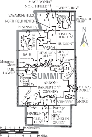
Cities
|
Hudson, Ohio Hudson is a city in Summit County, Ohio, United States. The population was 22,262 at the 2010 census. It is an affluent exurban community and is part of the Akron, Ohio Metropolitan Statistical Area... Macedonia, Ohio Macedonia is a city in Summit County, Ohio, United States. The population was 11,188 at the 2010 census. Macedonia is part of the Akron Metropolitan Statistical Area.-History:... Munroe Falls, Ohio Munroe Falls is a city located in the east-central portion of Summit County, Ohio, United States, between Stow and Tallmadge. It is a suburb of Akron and is part of the Akron Metropolitan Statistical Area... New Franklin, Ohio New Franklin is a city located at the southern edge of Summit County, Ohio, United States, in the northeastern part of the state. It is bounded by Coventry Township, as well as the cities of Barberton and Norton to the north; by Chippewa Township, Wayne County; by Clinton to the southwest; by Green... |
Norton, Ohio Norton is a city in Summit and Wayne counties in the U.S. state of Ohio. The population was 11,523 at the 2000 census.The Summit County portion of Norton is part of the Akron Metropolitan Statistical Area, while the small portion in Wayne County is part of the Wooster Micropolitan Statistical... Stow, Ohio Stow is a city in Summit County, Ohio, United States. The population was 32,139 at the 2000 census and 33,899 as of 2008. It is a suburban community that is part of the Akron metropolitan area. Stow is located adjacent to several other suburban communities in Summit and Portage Counties... Tallmadge, Ohio As of the census of 2000, there were 16,390 people, 6,273 households, and 4,711 families residing in the city. The population density was 1,173.9 people per square mile . There were 6,494 housing units at an average density of 465.1 per square mile... Twinsburg, Ohio As of the census of 2000, there were 17,006 people, 6,641 households, and 4,695 families residing in the city. The population density was 1,366.7 people per square mile . There were 6,871 housing units at an average density of 552.2 per square mile... |
Villages
|
Peninsula, Ohio Peninsula is a village in Summit County, Ohio, United States. The population was 602 at the 2000 census. It is part of the Akron Metropolitan Statistical Area.... Reminderville, Ohio Reminderville is a village in Summit County, Ohio, United States. The population was 2,347 at the 2000 census. It is part of the Akron Metropolitan Statistical Area.-Geography:Reminderville is located at .... Richfield, Ohio Richfield is a village in Summit County, Ohio, United States. The population was 3,286 at the 2000 census. The village and the adjacent Richfield Township are approximately equidistant between the downtown areas of Akron and Cleveland... Silver Lake, Ohio Silver Lake is a village in Summit County, Ohio, United States of America. It is an affluent suburb of Akron and is part of the Akron Metropolitan Statistical Area. The population was 3,019 at the 2000 census... |
Townships
|
Coventry Township, Summit County, Ohio Coventry Township is one of the nine townships of Summit County, Ohio, United States. The 2000 census found 10,900 people in the township.-Geography:Coventry Township is located in southern Summit County... Northfield Center Township, Summit County, Ohio Northfield Center Township is one of the nine townships of Summit County, Ohio, United States. The 2000 census found 4,931 people in the township.-Geography:Located in the northern part of the county, it borders the following townships and municipalities:... Richfield Township, Summit County, Ohio Richfield Township is one of the nine townships of Summit County, Ohio, United States. The 2000 census found 5,424 people in the township, 2,138 of whom lived in the unincorporated portions of the township.-Geography:... |
Sagamore Hills Township, Summit County, Ohio Sagamore Hills Township is one of the nine townships of Summit County, Ohio, United States. The 2000 census found 9,340 people in the township.-Geography:Located in the northwestern part of the county, it borders the following townships and municipalities:... Springfield Township, Summit County, Ohio Springfield Township is one of the nine townships of Summit County, Ohio, United States. The 2000 census found 15,168 people in the township.-Geography:Located in the southeastern part of the county, it borders the following townships and cities:... Twinsburg Township, Summit County, Ohio Twinsburg Township is one of the nine townships of Summit County, Ohio, United States. The 2000 census found 2,153 people in the unincorporated portions of the township.-Geography:Twinsburg Township's current area is much smaller than it was originally... |
Defunct townships
|
Northampton Township, Summit County, Ohio Northampton was one of the 16 original townships in Summit County, Ohio. It was in the middle of Summit County, bordering Akron and Cuyahoga Falls. No incorporated areas were formed within the township but Akron and Cuyahoga Falls expanded into Northamption via annexation. In 1986, Northampton... Portage Township, Summit County, Ohio Portage Township was one of the 16 original townships in Summit County, Ohio. It was in the middle of Summit County, containing Akron and Cuyahoga Falls and earlier part of Middlebury. Eventually it was absorbed by Akron and Cuyahoga Falls and ceased to exist. When created it occupied survey Town... |
Census-designated places
- Montrose-GhentMontrose-Ghent, OhioAs of the census of 2000, there were 5,261 people, 1,920 households, and 1,591 families residing in the CDP. The population density was 558.4 people per square mile . There were 1,987 housing units at an average density of 210.9/sq mi...
- Pigeon CreekPigeon Creek, OhioPigeon Creek is a census-designated place in Summit County, Ohio, United States. The population was 945 at the 2000 census. It is part of the Akron Metropolitan Statistical Area.-Geography:Pigeon Creek is located at ....
- Portage LakesPortage Lakes, OhioPortage Lakes is a census-designated place in Summit County, Ohio, United States. The population was 9,870 at the 2000 census. The city of Green is adjacent to the southeast and Akron on the north. The nearby Portage Lakes of the area include but are not limited to Turkeyfoot Lake, Nimisila...
Other communities
- GhentGhent, OhioGhent is an unincorporated hamlet in central Bath Township, Summit County, Ohio, United States. It lies in the area of Granger and Cleveland-Massillon Roads just north of the Ghent Road exit of Interstate 77. It is included in the Montrose-Ghent census-designated place. It has a number of local...
- Hammond's Corners
- MontroseMontrose, OhioMontrose is an area on the border between the Bath and Copley Townships of Summit County, Ohio, United States. It is an area of restaurants, stores, and businesses located along a stretch of State Route 18 near Interstate 77...
Parks
- Cuyahoga Valley National ParkCuyahoga Valley National ParkCuyahoga Valley National Park preserves and reclaims the rural landscape along the Cuyahoga River between Akron and Cleveland in Northeast Ohio. The park is the only national park in Ohio.Cuyahoga means "crooked river" in Mohawk....
(also extends north into Cuyahoga County) - Metro Parks, Serving Summit CountyMetro Parks, Serving Summit County' is a Metroparks system serving the citizens of Summit County, Ohio by managing in 14 developed parks, six conservation areas and more than of trails.The park district is fully supported by a levy, which voters are periodically asked to approve...
External links
- Official Summit County page
- Codified Ordinances of the County of Summit. Includes the county's charter. (Note: To expand the page's Contents, click on the yellow-folder icon.)
- The Summit Memory Project
- Special Collections Division of the Akron-Summit County Public Library
- Summit County Metro Parks
- Akron-Summit Convention and Visitors Bureau
- Summit County Myths
- Summit County, Ohio History and Genealogy
- Ohio and Erie Canal National Heritage Corridor, a National Park Service Discover Our Shared Heritage Travel Itinerary