
Williams County, Ohio
Encyclopedia
Williams County is a county located in the U.S. state
of Ohio
. As of 2010, the population was 37,642. http://quickfacts.census.gov/qfd/states/39/39171.html Its county seat
is Bryan
and is named for David Williams
, one of the captors of John André
in the American Revolutionary War
.
, the county has a total area of 423 square miles (1,095.6 km²).422 square miles (1,092 km²) of it is land and 1 square miles (2.6 km²) of it (0.31%) is water.
of 2000, there were 39,188 people, 15,105 households, and 10,664 families residing in the county. The population density
was 93 people per square mile (36/km²). There were 16,140 housing units at an average density of 38 per square mile (15/km²). The racial makeup of the county was 96.51% White
, 0.72% Black
or African American
, 0.23% Native American
, 0.52% Asian
, 0.01% Pacific Islander
, 1.19% from other races
, and 0.83% from two or more races. 2.68% of the population were Hispanic
or Latino
of any race. 43.6% were of German
, 17.7% American
, 8.1% English
and 5.8% Irish
ancestry according to Census 2000.
There were 15,105 households out of which 33.30% had children under the age of 18 living with them, 57.50% were married couples
living together, 9.00% had a female householder with no husband present, and 29.40% were non-families. 24.90% of all households were made up of individuals and 10.50% had someone living alone who was 65 years of age or older. The average household size was 2.52 and the average family size was 3.00.
In the county, the population was spread out with 26.20% under the age of 18, 8.30% from 18 to 24, 28.70% from 25 to 44, 22.90% from 45 to 64, and 13.90% who were 65 years of age or older. The median age was 37 years. For every 100 females there were 98.70 males. For every 100 females age 18 and over, there were 96.40 males.
The median income for a household in the county was $40,735, and the median income for a family was $47,398. Males had a median income of $33,476 versus $22,136 for females. The per capita income
for the county was $18,441. About 3.90% of families and 6.00% of the population were below the poverty line, including 6.20% of those under age 18 and 6.90% of those age 65 or over.
U.S. state
A U.S. state is any one of the 50 federated states of the United States of America that share sovereignty with the federal government. Because of this shared sovereignty, an American is a citizen both of the federal entity and of his or her state of domicile. Four states use the official title of...
of Ohio
Ohio
Ohio is a Midwestern state in the United States. The 34th largest state by area in the U.S.,it is the 7th‑most populous with over 11.5 million residents, containing several major American cities and seven metropolitan areas with populations of 500,000 or more.The state's capital is Columbus...
. As of 2010, the population was 37,642. http://quickfacts.census.gov/qfd/states/39/39171.html Its county seat
County seat
A county seat is an administrative center, or seat of government, for a county or civil parish. The term is primarily used in the United States....
is Bryan
Bryan, Ohio
As of the census of 2000, there were 8,333 people, 3,528 households, and 2,155 families residing in the city. The population density was 1,821.7 people per square mile . There were 3,733 housing units at an average density of 816.1 per square mile...
and is named for David Williams
David Williams (soldier)
David Williams was a militiaman from the state of New York during the American Revolution. In 1780, he participated in the capture of Major John André.Williams should not be confused with, and is not related to, David Williams of Massachusetts, a participant in the Boston Tea...
, one of the captors of John André
John André
John André was a British army officer hanged as a spy during the American War of Independence. This was due to an incident in which he attempted to assist Benedict Arnold's attempted surrender of the fort at West Point, New York to the British.-Early life:André was born on May 2, 1750 in London to...
in the American Revolutionary War
American Revolutionary War
The American Revolutionary War , the American War of Independence, or simply the Revolutionary War, began as a war between the Kingdom of Great Britain and thirteen British colonies in North America, and ended in a global war between several European great powers.The war was the result of the...
.
Geography
According to the U.S. Census BureauUnited States Census Bureau
The United States Census Bureau is the government agency that is responsible for the United States Census. It also gathers other national demographic and economic data...
, the county has a total area of 423 square miles (1,095.6 km²).422 square miles (1,092 km²) of it is land and 1 square miles (2.6 km²) of it (0.31%) is water.
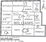
Adjacent counties
- Hillsdale County, MichiganHillsdale County, Michigan-Demographics:As of the census of 2000, there were 46,527 people, 17,335 households, and 12,550 families residing in the county. The population density was 78 people per square mile . There were 20,189 housing units at an average density of 34 per square mile...
(north) - Fulton CountyFulton County, OhioFulton County is a county located in the U.S. state of Ohio. As of 2010, the population was 42,698. Its county seat is Wauseon. Fulton County is named for Robert Fulton, inventor of the steamboat....
(east) - Henry CountyHenry County, OhioHenry County is a county located in the state of Ohio, United States. As of the 2010 census, the population was 28,215. Its county seat is Napoleon and is named for Patrick Henry, the Virginian famous for his "give me liberty or give me death" speech....
(southeast) - Defiance CountyDefiance County, OhioAs of the census of 2000, there were 39,500 people, 15,138 households, and 11,020 families residing in the county. The population density was 96 people per square mile . There were 16,040 housing units at an average density of 39 per square mile...
(south) - DeKalb County, IndianaDeKalb County, IndianaDeKalb County is a county located in the U.S. state of Indiana. Named for Revolutionary War hero Johann, Baron de Kalb , the county was created by the Indiana legislature in 1835 and organized in 1837. As of 2010, the population was 42,223...
(southwest) - Steuben County, IndianaSteuben County, IndianaSteuben County is a county located in the northeast corner of the U.S. state of Indiana. As of 2010, the population was 34,185. The county seat is Angola...
(northwest)
Demographics
As of the censusCensus
A census is the procedure of systematically acquiring and recording information about the members of a given population. It is a regularly occurring and official count of a particular population. The term is used mostly in connection with national population and housing censuses; other common...
of 2000, there were 39,188 people, 15,105 households, and 10,664 families residing in the county. The population density
Population density
Population density is a measurement of population per unit area or unit volume. It is frequently applied to living organisms, and particularly to humans...
was 93 people per square mile (36/km²). There were 16,140 housing units at an average density of 38 per square mile (15/km²). The racial makeup of the county was 96.51% White
Race (United States Census)
Race and ethnicity in the United States Census, as defined by the Federal Office of Management and Budget and the United States Census Bureau, are self-identification data items in which residents choose the race or races with which they most closely identify, and indicate whether or not they are...
, 0.72% Black
Race (United States Census)
Race and ethnicity in the United States Census, as defined by the Federal Office of Management and Budget and the United States Census Bureau, are self-identification data items in which residents choose the race or races with which they most closely identify, and indicate whether or not they are...
or African American
Race (United States Census)
Race and ethnicity in the United States Census, as defined by the Federal Office of Management and Budget and the United States Census Bureau, are self-identification data items in which residents choose the race or races with which they most closely identify, and indicate whether or not they are...
, 0.23% Native American
Race (United States Census)
Race and ethnicity in the United States Census, as defined by the Federal Office of Management and Budget and the United States Census Bureau, are self-identification data items in which residents choose the race or races with which they most closely identify, and indicate whether or not they are...
, 0.52% Asian
Race (United States Census)
Race and ethnicity in the United States Census, as defined by the Federal Office of Management and Budget and the United States Census Bureau, are self-identification data items in which residents choose the race or races with which they most closely identify, and indicate whether or not they are...
, 0.01% Pacific Islander
Race (United States Census)
Race and ethnicity in the United States Census, as defined by the Federal Office of Management and Budget and the United States Census Bureau, are self-identification data items in which residents choose the race or races with which they most closely identify, and indicate whether or not they are...
, 1.19% from other races
Race (United States Census)
Race and ethnicity in the United States Census, as defined by the Federal Office of Management and Budget and the United States Census Bureau, are self-identification data items in which residents choose the race or races with which they most closely identify, and indicate whether or not they are...
, and 0.83% from two or more races. 2.68% of the population were Hispanic
Race (United States Census)
Race and ethnicity in the United States Census, as defined by the Federal Office of Management and Budget and the United States Census Bureau, are self-identification data items in which residents choose the race or races with which they most closely identify, and indicate whether or not they are...
or Latino
Race (United States Census)
Race and ethnicity in the United States Census, as defined by the Federal Office of Management and Budget and the United States Census Bureau, are self-identification data items in which residents choose the race or races with which they most closely identify, and indicate whether or not they are...
of any race. 43.6% were of German
Germans
The Germans are a Germanic ethnic group native to Central Europe. The English term Germans has referred to the German-speaking population of the Holy Roman Empire since the Late Middle Ages....
, 17.7% American
United States
The United States of America is a federal constitutional republic comprising fifty states and a federal district...
, 8.1% English
English people
The English are a nation and ethnic group native to England, who speak English. The English identity is of early mediaeval origin, when they were known in Old English as the Anglecynn. England is now a country of the United Kingdom, and the majority of English people in England are British Citizens...
and 5.8% Irish
Irish people
The Irish people are an ethnic group who originate in Ireland, an island in northwestern Europe. Ireland has been populated for around 9,000 years , with the Irish people's earliest ancestors recorded having legends of being descended from groups such as the Nemedians, Fomorians, Fir Bolg, Tuatha...
ancestry according to Census 2000.
There were 15,105 households out of which 33.30% had children under the age of 18 living with them, 57.50% were married couples
Marriage
Marriage is a social union or legal contract between people that creates kinship. It is an institution in which interpersonal relationships, usually intimate and sexual, are acknowledged in a variety of ways, depending on the culture or subculture in which it is found...
living together, 9.00% had a female householder with no husband present, and 29.40% were non-families. 24.90% of all households were made up of individuals and 10.50% had someone living alone who was 65 years of age or older. The average household size was 2.52 and the average family size was 3.00.
In the county, the population was spread out with 26.20% under the age of 18, 8.30% from 18 to 24, 28.70% from 25 to 44, 22.90% from 45 to 64, and 13.90% who were 65 years of age or older. The median age was 37 years. For every 100 females there were 98.70 males. For every 100 females age 18 and over, there were 96.40 males.
The median income for a household in the county was $40,735, and the median income for a family was $47,398. Males had a median income of $33,476 versus $22,136 for females. The per capita income
Per capita income
Per capita income or income per person is a measure of mean income within an economic aggregate, such as a country or city. It is calculated by taking a measure of all sources of income in the aggregate and dividing it by the total population...
for the county was $18,441. About 3.90% of families and 6.00% of the population were below the poverty line, including 6.20% of those under age 18 and 6.90% of those age 65 or over.
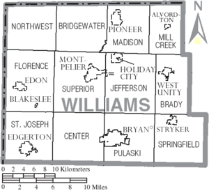
Communities
Villages
|
Montpelier, Ohio Montpelier is a village in Williams County, Ohio, United States. The population was 4,320 at the 2000 census.-Geography:Montpelier is located at .... Pioneer, Ohio Pioneer is a village in Williams County, Ohio, United States. The population was 1,369 at the 2010 census.-History:Earliest recorded settlers of Pioneer were P.W. Norris and Owen McCarty , who were hired to clear James A. Rogers land in 1842-3. That land was section 17 of Williams County... Stryker, Ohio Stryker is a village in Williams County, Ohio, United States. The population was 1,406 at the 2000 census.-History:Stryker is the oldest settlement in Williams County... West Unity, Ohio West Unity is a village in Williams County, Ohio, United States. The population was 1,790 at the 2000 census.-Geography:West Unity is located at .... |
Townships
|
Jefferson Township, Williams County, Ohio Jefferson Township is one of the twelve townships of Williams County, Ohio, United States. The 2000 census found 2,021 people in the township, 1,969 of whom lived in the unincorporated portions of the township.-Geography:... Madison Township, Williams County, Ohio Madison Township is one of the twelve townships of Williams County, Ohio, United States. The 2000 census found 2,539 people in the township, 1,079 of whom lived in the unincorporated portions of the township.-Geography:... Mill Creek Township, Williams County, Ohio Mill Creek Township is one of the twelve townships of Williams County, Ohio, United States. The 2000 census found 935 people in the township, 630 of whom lived in the unincorporated portions of the township.-Geography:... Northwest Township, Williams County, Ohio Northwest Township is one of the twelve townships of Williams County, Ohio, United States. The 2000 census found 1,384 people in the township.-Geography:... |
Pulaski Township, Williams County, Ohio Pulaski Township is one of the twelve townships of Williams County, Ohio, United States. The 2000 census found 2,628 people in the township.-Geography:Located in the southern part of the county, it borders the following townships:... St. Joseph Township, Williams County, Ohio St. Joseph Township is one of the twelve townships of Williams County, Ohio, United States. The 2000 census found 3,227 people in the township, 1,821 of whom lived in the unincorporated portions of the township.-Geography:... Springfield Township, Williams County, Ohio Springfield Township is one of the twelve townships of Williams County, Ohio, United States. The 2000 census found 2,958 people in the township, 841 of whom lived in the unincorporated portions of the township.-Geography:... Superior Township, Williams County, Ohio Superior Township is one of the twelve townships of Williams County, Ohio, United States. The 2000 census found 5,769 people in the township, 1,452 of whom lived in the unincorporated portions of the township.-Geography:... |
Other communities
|
Kunkle, Ohio Kunkle is a census-designated place in southeastern Madison Township, Williams County, Ohio, United States. It is located approximately 65 miles west of Toledo.... |
Melbern, Ohio Melbern is a small unincorporated community in western Center Township, Williams County, Ohio, United States. It is situated on County Road 9 south of County Road D.-Geography:... Williams Center, Ohio Williams Center is an unincorporated community in southeastern Center Township, Williams County, Ohio, United States. It lies at the intersection of State Routes 2 and 576. The headwaters of the Little Lick Creek, a subsidiary of the Maumee River through Lick Creek and the Tiffin River, are... |