
Portage County, Ohio
Encyclopedia
Portage County is a county located in the U.S. state
of Ohio
. The population was 152,061 at the 2000 Census and 161,419 at the 2010 Census. Its county seat
is Ravenna
. Portage County is named for the portage
between the Cuyahoga
and Tuscarawas
Rivers. Portage County is part of the Akron
Metropolitan Statistical Area
.
path called "Portage Trail", which ran between the Cuyahoga
and Tuscarawas
rivers, where travelers portage
d their canoes. The location of the trail today is within the boundaries of neighboring Summit County
.
The first European settler in what is now Portage County was Abraham Honey in 1798 in the area now known as Mantua Township
, followed by Asa Hall in what is now Atwater Township
in April 1799. In June 1799, Benjamin Tappan
, Jr. arrived and founded Ravenna
, David Daniels came to what is now Palmyra Township
, and Ebenezer Sheldon settled in what is now Aurora.
When first settled, the area that presently constitutes Portage County was part of the original Jefferson County
, which had been organized in 1797. In 1800, the area was made part of Trumbull County
, which followed the boundaries of the Connecticut Western Reserve
. In 1802, all of what is now Portage County was organized under the name of Franklin Township
with other townships being formed later. On February 10, 1807 the Ohio state legislature passed the act to create Portage County from Trumbull County and it took effect June 7, 1807. Portage County remained attached to Trumbull County until June 8, 1808, when the first elections were held. Initially, the county included a large area of the Western Reserve that encompassed most of present-day Summit County, all of Medina and Huron counties, and parts of Lorain and Ashland counties. There were six organized townships in 1808: Franklin, Deerfield, Aurora, Hiram, Springfield, and Hudson with new townships organized later, reaching a maximum of 30. The present-day boundaries of Portage County were established in 1840 following the 1812 creation of Medina County, a slight boundary adjustment in 1827 with Cuyahoga County, and finally the creation of Summit County in 1840, which took 10 townships from Portage County along with 3 townships from Medina County and two from Stark County.
 According to the U.S. Census Bureau
, the county has a total area of 507 square miles (1,313 km²).492 square miles (1,275 km²) of it is land and 15 square miles (38 km²) of it (2.90%) is water.
West Branch State Park
is a very large state park in central Portage County, consisting of a large green surrounding the Michael J. Kirwan Dam and Reservoir. There are a number of smaller state and local parks.
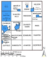
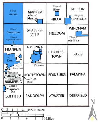
containing 9 cities
and villages; and two incorporated townships which are fully occupied by one city each.
Under Ohio law, there are two types of incorporated municipal jurisdictions: cities and villages, and any territory within a county that is not part of an incorporated municipality (city or village), is part of a township. Townships have limited local government and services.
There are 18 unincorporated townships:
There are 11 villages and cities that were formed from all or parts of the original 20 townships:
In addition to the above, a small part of Tallmadge
is in land that was formerly part of Brimfield Township (the rest of the city is in Summit County
).
Two small unincorporated communities
in Portage County have their own post office
s:
There is one unincorporated Census-designated place
, in Brimfield Township:
The Camp Ravenna Joint Military Training Center, formerly known as the Ravenna Training and Logistics Site and commonly known as the Ravenna Arsenal, occupies much of the land in Charlestown, Paris, and Windham Township, as well as a small part of Freedom Township.
of 2000, there were 152,061 people, 56,449 households, and 39,175 families residing in the county. The population density
was 309 people per square mile (119/km²). There were 60,096 housing units at an average density of 122 per square mile (47/km²). The racial makeup of the county was 94.40% White
, 3.18% Black
or African American
, 0.18% Native American
, 0.82% Asian
, 0.01% Pacific Islander
, 0.22% from other races
, and 1.19% from two or more races. 0.72% of the population were Hispanic
or Latino
of any race. 23.5% were of German
, 11.0% Irish
, 9.9% Italian
, 9.7% English
, 9.7% American
and 5.2% Polish ancestry according to Census 2000. 96.1% spoke English
and 1.2% Spanish
as their first language.
There were 56,449 households out of which 32.30% had children under the age of 18 living with them, 55.60% were married couples
living together, 10.10% had a female householder with no husband present, and 30.60% were non-families. 23.30% of all households were made up of individuals and 7.40% had someone living alone who was 65 years of age or older. The average household size was 2.56 and the average family size was 3.03.
In the county, the population was spread out with 23.70% under the age of 18, 14.30% from 18 to 24, 28.60% from 25 to 44, 22.30% from 45 to 64, and 11.00% who were 65 years of age or older. The median age was 34 years. For every 100 females there were 95.40 males. For every 100 females age 18 and over, there were 92.40 males.
The median income for a household in the county was $44,347, and the median income for a family was $52,820. Males had a median income of $37,434 versus $26,232 for females. The per capita income
for the county was $20,428. About 5.90% of families and 9.30% of the population were below the poverty line, including 9.90% of those under age 18 and 5.70% of those age 65 or over.
 In addition, there are parts of five neighboring districts which serve portions of Portage County residents.
*= Although the village of Mogadore is located in both Summit and Portage Counties its school facilities are physically located in Summit County.
U.S. state
A U.S. state is any one of the 50 federated states of the United States of America that share sovereignty with the federal government. Because of this shared sovereignty, an American is a citizen both of the federal entity and of his or her state of domicile. Four states use the official title of...
of Ohio
Ohio
Ohio is a Midwestern state in the United States. The 34th largest state by area in the U.S.,it is the 7th‑most populous with over 11.5 million residents, containing several major American cities and seven metropolitan areas with populations of 500,000 or more.The state's capital is Columbus...
. The population was 152,061 at the 2000 Census and 161,419 at the 2010 Census. Its county seat
County seat
A county seat is an administrative center, or seat of government, for a county or civil parish. The term is primarily used in the United States....
is Ravenna
Ravenna, Ohio
* Chris Bangle; automobile designer* Bill Bower, last surviving pilot of the Doolittle Raid* David D. Busch; best-selling author* William Rufus Day; U.S. Supreme Court justice* Calvin Hampton; Classical organist* Robert B...
. Portage County is named for the portage
Portage
Portage or portaging refers to the practice of carrying watercraft or cargo over land to avoid river obstacles, or between two bodies of water. A place where this carrying occurs is also called a portage; a person doing the carrying is called a porter.The English word portage is derived from the...
between the Cuyahoga
Cuyahoga River
The Cuyahoga River is located in Northeast Ohio in the United States. Outside of Ohio, the river is most famous for being "the river that caught fire", helping to spur the environmental movement in the late 1960s...
and Tuscarawas
Tuscarawas River
The Tuscarawas River is a principal tributary of the Muskingum River, 129.9 miles long, in northeastern Ohio in the United States...
Rivers. Portage County is part of the Akron
Akron, Ohio
Akron , is the fifth largest city in the U.S. state of Ohio and the county seat of Summit County. It is located in the Great Lakes region approximately south of Lake Erie along the Little Cuyahoga River. As of the 2010 census, the city had a population of 199,110. The Akron Metropolitan...
Metropolitan Statistical Area
Akron metropolitan area
The Akron Metropolitan Statistical Area, as defined by the United States Census Bureau, is an area consisting of two counties, Summit and Portage, in northeastern Ohio and is anchored by the city of Akron...
.
History
The name "Portage" comes from an old Native AmericanNative Americans in the United States
Native Americans in the United States are the indigenous peoples in North America within the boundaries of the present-day continental United States, parts of Alaska, and the island state of Hawaii. They are composed of numerous, distinct tribes, states, and ethnic groups, many of which survive as...
path called "Portage Trail", which ran between the Cuyahoga
Cuyahoga River
The Cuyahoga River is located in Northeast Ohio in the United States. Outside of Ohio, the river is most famous for being "the river that caught fire", helping to spur the environmental movement in the late 1960s...
and Tuscarawas
Tuscarawas River
The Tuscarawas River is a principal tributary of the Muskingum River, 129.9 miles long, in northeastern Ohio in the United States...
rivers, where travelers portage
Portage
Portage or portaging refers to the practice of carrying watercraft or cargo over land to avoid river obstacles, or between two bodies of water. A place where this carrying occurs is also called a portage; a person doing the carrying is called a porter.The English word portage is derived from the...
d their canoes. The location of the trail today is within the boundaries of neighboring Summit County
Summit County, Ohio
Summit County is an urban county located in the state of Ohio, United States. As of the 2000 census, the population was 542,899. In the 2010 Census the population was 541,781. Its county seat is Akron...
.
The first European settler in what is now Portage County was Abraham Honey in 1798 in the area now known as Mantua Township
Mantua Township, Portage County, Ohio
The village of Mantua, which became independent of the township in 1993, is located in southern Mantua Township.Formed from the Connecticut Western Reserve, Mantua Township covers an area of .-Notable people:...
, followed by Asa Hall in what is now Atwater Township
Atwater Township, Portage County, Ohio
Atwater Township is one of the eighteen townships of Portage County, Ohio, United States. The 2000 census found 2,762 people in the township.-Geography:Located in the southern part of the county, it borders the following townships:...
in April 1799. In June 1799, Benjamin Tappan
Benjamin Tappan
Benjamin Tappan was an Ohio judge and Democratic politician who served in the Ohio State Senate and the United States Senate...
, Jr. arrived and founded Ravenna
Ravenna, Ohio
* Chris Bangle; automobile designer* Bill Bower, last surviving pilot of the Doolittle Raid* David D. Busch; best-selling author* William Rufus Day; U.S. Supreme Court justice* Calvin Hampton; Classical organist* Robert B...
, David Daniels came to what is now Palmyra Township
Palmyra Township, Portage County, Ohio
Palmyra Township is one of the eighteen townships of Portage County, Ohio, United States. The 2000 census found 2,785 people in the township.-Geography:Located in the southeastern part of the county, it borders the following townships:...
, and Ebenezer Sheldon settled in what is now Aurora.
When first settled, the area that presently constitutes Portage County was part of the original Jefferson County
Jefferson County, Ohio
Jefferson County is a county located in the state of Ohio. As of 2010, the population was 69,709. Its county seat is Steubenville and is named for Thomas Jefferson, who was at the time Vice President....
, which had been organized in 1797. In 1800, the area was made part of Trumbull County
Trumbull County, Ohio
As of the census of 2000, there were 225,116 people, 89,020 households, and 61,690 families residing in the county. The population density was 365 people per square mile . There were 95,117 housing units at an average density of 154 per square mile...
, which followed the boundaries of the Connecticut Western Reserve
Connecticut Western Reserve
The Connecticut Western Reserve was land claimed by Connecticut from 1662 to 1800 in the Northwest Territory in what is now northeastern Ohio.-History:...
. In 1802, all of what is now Portage County was organized under the name of Franklin Township
Franklin Township, Portage County, Ohio
Franklin Township is a civil township located in Portage County, Ohio, United States. It is located along the Cuyahoga River in Northeast Ohio on the western edge of the county. The 2000 census found 5,276 people in the township...
with other townships being formed later. On February 10, 1807 the Ohio state legislature passed the act to create Portage County from Trumbull County and it took effect June 7, 1807. Portage County remained attached to Trumbull County until June 8, 1808, when the first elections were held. Initially, the county included a large area of the Western Reserve that encompassed most of present-day Summit County, all of Medina and Huron counties, and parts of Lorain and Ashland counties. There were six organized townships in 1808: Franklin, Deerfield, Aurora, Hiram, Springfield, and Hudson with new townships organized later, reaching a maximum of 30. The present-day boundaries of Portage County were established in 1840 following the 1812 creation of Medina County, a slight boundary adjustment in 1827 with Cuyahoga County, and finally the creation of Summit County in 1840, which took 10 townships from Portage County along with 3 townships from Medina County and two from Stark County.
Geography
United States Census Bureau
The United States Census Bureau is the government agency that is responsible for the United States Census. It also gathers other national demographic and economic data...
, the county has a total area of 507 square miles (1,313 km²).492 square miles (1,275 km²) of it is land and 15 square miles (38 km²) of it (2.90%) is water.
West Branch State Park
West Branch State Park
West Branch State Park is a state park located east of Ravenna, Ohio on the west branch of the Mahoning River. The park encompasses of land and of water. Boating, fishing and swimming are permitted on the Michael J. Kirwan Reservoir...
is a very large state park in central Portage County, consisting of a large green surrounding the Michael J. Kirwan Dam and Reservoir. There are a number of smaller state and local parks.
Communities
Portage County is arranged as a 4x5 grid of 20 rectangles: 18 unincorporated townshipsTownship (United States)
A township in the United States is a small geographic area. Townships range in size from 6 to 54 square miles , with being the norm.The term is used in three ways....
containing 9 cities
City
A city is a relatively large and permanent settlement. Although there is no agreement on how a city is distinguished from a town within general English language meanings, many cities have a particular administrative, legal, or historical status based on local law.For example, in the U.S...
and villages; and two incorporated townships which are fully occupied by one city each.
Under Ohio law, there are two types of incorporated municipal jurisdictions: cities and villages, and any territory within a county that is not part of an incorporated municipality (city or village), is part of a township. Townships have limited local government and services.
There are 18 unincorporated townships:
- Atwater TownshipAtwater Township, Portage County, OhioAtwater Township is one of the eighteen townships of Portage County, Ohio, United States. The 2000 census found 2,762 people in the township.-Geography:Located in the southern part of the county, it borders the following townships:...
- Brimfield TownshipBrimfield Township, Portage County, OhioBrimfield Township is one of the eighteen townships of Portage County, Ohio, United States. The 2000 census found 7,963 people in the township.-Geography:Located in the southwestern part of the county, it borders the following townships and cities:...
- Charlestown TownshipCharlestown Township, Portage County, OhioCharlestown Township is one of the eighteen townships of Portage County, Ohio, United States. The 2000 census found 2,003 people in the township.-Geography:Located in the center of the county, it borders the following townships:*Freedom Township - north...
- Deerfield TownshipDeerfield Township, Portage County, OhioDeerfield Township is one of the eighteen townships of Portage County, Ohio, United States. The 2000 census found 3,211 people in the township.-Geography:Located in the southeastern corner of the county, it borders the following townships:...
- Edinburg TownshipEdinburg Township, Portage County, OhioEdinburg Township is one of the eighteen townships of Portage County, Ohio, United States. The 2000 census found 2,344 people in the township.-Geography:Located in the southeastern part of the county, it borders the following townships:...
- Franklin TownshipFranklin Township, Portage County, OhioFranklin Township is a civil township located in Portage County, Ohio, United States. It is located along the Cuyahoga River in Northeast Ohio on the western edge of the county. The 2000 census found 5,276 people in the township...
- Freedom TownshipFreedom Township, Portage County, OhioFreedom Township is one of the eighteen townships of Portage County, Ohio, United States. The 2000 census found 2,751 people in the township.-Geography:Located in the northeastern part of the county, it borders the following townships:...
- Hiram TownshipHiram Township, Portage County, OhioHiram Township is one of the eighteen townships of Portage County, Ohio, United States. The 2000 census found 2,296 people in the township.-Geography:Located in the northern part of the county, it borders the following other townships:...
- Mantua TownshipMantua Township, Portage County, OhioThe village of Mantua, which became independent of the township in 1993, is located in southern Mantua Township.Formed from the Connecticut Western Reserve, Mantua Township covers an area of .-Notable people:...
- Nelson TownshipNelson Township, Portage County, OhioNelson Township is one of the eighteen townships of Portage County, Ohio, United States. The 2000 census found 2,985 people in the township.-Geography:...
- Palmyra TownshipPalmyra Township, Portage County, OhioPalmyra Township is one of the eighteen townships of Portage County, Ohio, United States. The 2000 census found 2,785 people in the township.-Geography:Located in the southeastern part of the county, it borders the following townships:...
- Paris TownshipParis Township, Portage County, OhioParis Township is one of the eighteen townships of Portage County, Ohio, United States. The 2000 census found 1,827 people in the township.-Geography:Located in the eastern part of the county, it borders the following townships:*Windham Township - north...
- Randolph TownshipRandolph Township, Portage County, OhioRandolph Township is one of the eighteen townships of Portage County, Ohio, United States. The 2000 census found 5,504 people in the township.-Geography:Located in the southern part of the county, it borders the following townships:...
- Ravenna TownshipRavenna Township, Portage County, OhioRavenna Township is one of the eighteen townships of Portage County, Ohio, United States. The 2000 census found 9,270 people in the township.-Geography:Located in the center of the county, it borders the following townships and city:...
- Rootstown TownshipRootstown Township, Portage County, OhioRootstown Township is one of the eighteen townships of Portage County, Ohio, United States. The 2000 census found 7,212 people in the township.-Geography:Located in the southwestern part of the county, it borders the following townships:...
- Shalersville TownshipShalersville Township, Portage County, OhioShalersville Township is one of the eighteen townships of Portage County, Ohio, United States. The 2000 census found 5,976 people in the township.-Geography:Located in the northwestern part of the county, it borders the following other townships and cities:...
- Suffield TownshipSuffield Township, Portage County, OhioSuffield Township is one of the eighteen townships of Portage County, Ohio, United States. The 2000 census found 6,383 people in the township.-Geography:Located in the southwestern corner of the county, it borders the following townships and municipalities:...
- Windham TownshipWindham Township, Portage County, OhioWindham Township is one of the eighteen townships of Portage County, Ohio, United States. The 2000 census found 2,060 people in the township.-Name and history:Named for the town of Windham, Connecticut, it is the only Windham Township statewide....
There are 11 villages and cities that were formed from all or parts of the original 20 townships:
- Aurora city (fully occupies the former Aurora Township)
- Brady Lake villageBrady Lake, OhioBrady Lake is a village in Portage County, Ohio, United States. The population was 513 at the 2000 census and 497 in the 2006 estimate. Incorporated in 1927, it originally developed as an amusement park and summer resort that opened in 1891. It was formed from a small portion of Franklin Township...
(Franklin Township) - Garrettsville villageGarrettsville, OhioGarrettsville is a village in Portage County, Ohio, United States. It was formed from portions of Hiram, Nelson, and Freedom townships in the Connecticut Western Reserve. The population was 2,262 at the 2000 census. On July 1, 2006, the U.S. Census Bureau estimated that 2,203 people resided in the...
(Hiram and Nelson Townships) - Hiram villageHiram, OhioHiram is a village in Portage County, Ohio, United States. It was formed from portions of Hiram Township in the Connecticut Western Reserve. The population was 1,242 at the 2000 census...
(Hiram Township) - Kent cityKent, OhioKent is a city in the U.S. state of Ohio and the largest city in Portage County. It is located along the Cuyahoga River in Northeastern Ohio on the western edge of the county. The population was 27,906 at the 2000 United States Census and 28,904 in the 2010 Census...
(Franklin Township & small portion of Brimfield Township) - Mantua villageMantua, OhioMantua is a village in Portage County, Ohio, United States. It was formed from portions of Mantua Township in the Connecticut Western Reserve. The population was 1,046 at the 2000 census. It is part of the Akron Metropolitan Statistical Area.-History:...
(Mantua Township) - Mogadore villageMogadore, OhioMogadore is a village in Portage and Summit counties in the U.S. state of Ohio. It is a suburb of Akron and is part of the Akron Metropolitan Statistical Area...
(Suffield Township) - Ravenna cityRavenna, Ohio* Chris Bangle; automobile designer* Bill Bower, last surviving pilot of the Doolittle Raid* David D. Busch; best-selling author* William Rufus Day; U.S. Supreme Court justice* Calvin Hampton; Classical organist* Robert B...
(Ravenna Township) - Streetsboro cityStreetsboro, OhioStreetsboro is a city in Portage County, Ohio, United States. It is formed from the former township of Streetsboro, which was formed from the Connecticut Western Reserve. It is nearly co-extant with the former Streetsboro Township; the village of Sugar Bush Knolls was also formed in part from a...
(occupies most of the former Streetsboro township) - Sugar Bush Knolls villageSugar Bush Knolls, OhioSugar Bush Knolls is a village in Portage County, Ohio, United States. It was formed from portions of Streetsboro and Franklin townships in 1964. The population was 227 at the 2000 census. It is essentially made up of a single affluent subdivision...
(Streetsboro and Franklin Townships) - Windham villageWindham, OhioWindham is a village located in Portage County, Ohio, United States. It is formed from portions of Windham Township, one of the original townships of the Connecticut Western Reserve. The population was 2,209 at the 2010 census. In 1942, the US government chose Windham as the site of an army camp...
(Windham Township)
In addition to the above, a small part of Tallmadge
Tallmadge, Ohio
As of the census of 2000, there were 16,390 people, 6,273 households, and 4,711 families residing in the city. The population density was 1,173.9 people per square mile . There were 6,494 housing units at an average density of 465.1 per square mile...
is in land that was formerly part of Brimfield Township (the rest of the city is in Summit County
Summit County, Ohio
Summit County is an urban county located in the state of Ohio, United States. As of the 2000 census, the population was 542,899. In the 2010 Census the population was 541,781. Its county seat is Akron...
).
Two small unincorporated communities
Unincorporated area
In law, an unincorporated area is a region of land that is not a part of any municipality.To "incorporate" in this context means to form a municipal corporation, a city, town, or village with its own government. An unincorporated community is usually not subject to or taxed by a municipal government...
in Portage County have their own post office
Post office
A post office is a facility forming part of a postal system for the posting, receipt, sorting, handling, transmission or delivery of mail.Post offices offer mail-related services such as post office boxes, postage and packaging supplies...
s:
- DiamondDiamond, OhioDiamond is an unincorporated community in eastern Palmyra Township, Portage County, Ohio, United States. Although it is unincorporated, it has a post office, with the ZIP code of 44412. The community is part of the Akron Metropolitan Statistical Area. Interstate 76 travels near Diamond.-Notable...
- WaylandWayland, OhioWayland is an unincorporated community in western Paris Township, Portage County, Ohio, United States. It is located at latitude 41.161 and longitude -81.071, with an elevation of 948 feet. Although it is unincorporated, it has a post office, with the ZIP code of 44285...
There is one unincorporated Census-designated place
Census-designated place
A census-designated place is a concentration of population identified by the United States Census Bureau for statistical purposes. CDPs are delineated for each decennial census as the statistical counterparts of incorporated places such as cities, towns and villages...
, in Brimfield Township:
- BrimfieldBrimfield, OhioBrimfield is a census-designated place in Portage County, Ohio, United States. As of the 2000 census, the CDP had a population of 3,248. It is located in the central part of Brimfield Township , a rural area between the Ohio cities of Akron and Kent with light industry, strip-malls, subdivisions,...
The Camp Ravenna Joint Military Training Center, formerly known as the Ravenna Training and Logistics Site and commonly known as the Ravenna Arsenal, occupies much of the land in Charlestown, Paris, and Windham Township, as well as a small part of Freedom Township.
Adjacent counties
- Geauga CountyGeauga County, OhioGeauga County is a county located in the state of Ohio, United States. As of the 2010 census, the population was 93,389. It is named for a Native American word meaning "raccoon". The county seat is Chardon...
(north) - Trumbull CountyTrumbull County, OhioAs of the census of 2000, there were 225,116 people, 89,020 households, and 61,690 families residing in the county. The population density was 365 people per square mile . There were 95,117 housing units at an average density of 154 per square mile...
(east) - Mahoning County (southeast)
- Stark CountyStark County, OhioStark County is a county located in the U.S. state of Ohio. As of the 2010 census, the population was 375,586. It is included in the Canton-Massillon, Ohio Metropolitan Statistical Area....
(south) - Summit CountySummit County, OhioSummit County is an urban county located in the state of Ohio, United States. As of the 2000 census, the population was 542,899. In the 2010 Census the population was 541,781. Its county seat is Akron...
(west) - Cuyahoga CountyCuyahoga County, OhioCuyahoga County is a county located in the state of Ohio, United States. It is the most populous county in Ohio; as of the 2010 census, the population was 1,280,122. Its county seat is Cleveland. Cuyahoga County is part of Greater Cleveland, a metropolitan area, and Northeast Ohio, a...
(northwest corner)
Major highways
 Interstate 76Interstate 76 (east)Interstate 76 is an Interstate Highway in the United States, running 435 miles from an interchange with Interstate 71 west of Akron, Ohio, east to Interstate 295 near Camden, New Jersey....
 Interstate 80Interstate 80Interstate 80 is the second-longest Interstate Highway in the United States, following Interstate 90. It is a transcontinental artery running from downtown San Francisco, California to Teaneck, New Jersey in the New York City Metropolitan Area...
(Ohio TurnpikeOhio TurnpikeThe Ohio Turnpike, officially the James W. Shocknessy Ohio Turnpike, is a -long, limited-access toll highway in the U.S. state of Ohio, serving as a primary corridor to Chicago and Pittsburgh...
) Interstate 480Interstate 480 (Ohio)Interstate 480 is a loop highway that connects the Ohio Turnpike with suburban Cleveland, Ohio. The highway is officially designated the Outerbelt South Freeway, but it is rarely referred to by that name....
 U.S. Route 224U.S. Route 224U.S. Route 224 is a spur of U.S. Route 24. It currently runs for 289 miles from New Castle, Pennsylvania at Pennsylvania Route 18 to Huntington, Indiana at U.S. Route 24. It passes through the states of Pennsylvania, Ohio and Indiana...
 State Route 14
Demographics
As of the censusCensus
A census is the procedure of systematically acquiring and recording information about the members of a given population. It is a regularly occurring and official count of a particular population. The term is used mostly in connection with national population and housing censuses; other common...
of 2000, there were 152,061 people, 56,449 households, and 39,175 families residing in the county. The population density
Population density
Population density is a measurement of population per unit area or unit volume. It is frequently applied to living organisms, and particularly to humans...
was 309 people per square mile (119/km²). There were 60,096 housing units at an average density of 122 per square mile (47/km²). The racial makeup of the county was 94.40% White
Race (United States Census)
Race and ethnicity in the United States Census, as defined by the Federal Office of Management and Budget and the United States Census Bureau, are self-identification data items in which residents choose the race or races with which they most closely identify, and indicate whether or not they are...
, 3.18% Black
Race (United States Census)
Race and ethnicity in the United States Census, as defined by the Federal Office of Management and Budget and the United States Census Bureau, are self-identification data items in which residents choose the race or races with which they most closely identify, and indicate whether or not they are...
or African American
Race (United States Census)
Race and ethnicity in the United States Census, as defined by the Federal Office of Management and Budget and the United States Census Bureau, are self-identification data items in which residents choose the race or races with which they most closely identify, and indicate whether or not they are...
, 0.18% Native American
Race (United States Census)
Race and ethnicity in the United States Census, as defined by the Federal Office of Management and Budget and the United States Census Bureau, are self-identification data items in which residents choose the race or races with which they most closely identify, and indicate whether or not they are...
, 0.82% Asian
Race (United States Census)
Race and ethnicity in the United States Census, as defined by the Federal Office of Management and Budget and the United States Census Bureau, are self-identification data items in which residents choose the race or races with which they most closely identify, and indicate whether or not they are...
, 0.01% Pacific Islander
Race (United States Census)
Race and ethnicity in the United States Census, as defined by the Federal Office of Management and Budget and the United States Census Bureau, are self-identification data items in which residents choose the race or races with which they most closely identify, and indicate whether or not they are...
, 0.22% from other races
Race (United States Census)
Race and ethnicity in the United States Census, as defined by the Federal Office of Management and Budget and the United States Census Bureau, are self-identification data items in which residents choose the race or races with which they most closely identify, and indicate whether or not they are...
, and 1.19% from two or more races. 0.72% of the population were Hispanic
Race (United States Census)
Race and ethnicity in the United States Census, as defined by the Federal Office of Management and Budget and the United States Census Bureau, are self-identification data items in which residents choose the race or races with which they most closely identify, and indicate whether or not they are...
or Latino
Race (United States Census)
Race and ethnicity in the United States Census, as defined by the Federal Office of Management and Budget and the United States Census Bureau, are self-identification data items in which residents choose the race or races with which they most closely identify, and indicate whether or not they are...
of any race. 23.5% were of German
Germans
The Germans are a Germanic ethnic group native to Central Europe. The English term Germans has referred to the German-speaking population of the Holy Roman Empire since the Late Middle Ages....
, 11.0% Irish
Irish people
The Irish people are an ethnic group who originate in Ireland, an island in northwestern Europe. Ireland has been populated for around 9,000 years , with the Irish people's earliest ancestors recorded having legends of being descended from groups such as the Nemedians, Fomorians, Fir Bolg, Tuatha...
, 9.9% Italian
Italian people
The Italian people are an ethnic group that share a common Italian culture, ancestry and speak the Italian language as a mother tongue. Within Italy, Italians are defined by citizenship, regardless of ancestry or country of residence , and are distinguished from people...
, 9.7% English
English people
The English are a nation and ethnic group native to England, who speak English. The English identity is of early mediaeval origin, when they were known in Old English as the Anglecynn. England is now a country of the United Kingdom, and the majority of English people in England are British Citizens...
, 9.7% American
United States
The United States of America is a federal constitutional republic comprising fifty states and a federal district...
and 5.2% Polish ancestry according to Census 2000. 96.1% spoke English
English language
English is a West Germanic language that arose in the Anglo-Saxon kingdoms of England and spread into what was to become south-east Scotland under the influence of the Anglian medieval kingdom of Northumbria...
and 1.2% Spanish
Spanish language
Spanish , also known as Castilian , is a Romance language in the Ibero-Romance group that evolved from several languages and dialects in central-northern Iberia around the 9th century and gradually spread with the expansion of the Kingdom of Castile into central and southern Iberia during the...
as their first language.
There were 56,449 households out of which 32.30% had children under the age of 18 living with them, 55.60% were married couples
Marriage
Marriage is a social union or legal contract between people that creates kinship. It is an institution in which interpersonal relationships, usually intimate and sexual, are acknowledged in a variety of ways, depending on the culture or subculture in which it is found...
living together, 10.10% had a female householder with no husband present, and 30.60% were non-families. 23.30% of all households were made up of individuals and 7.40% had someone living alone who was 65 years of age or older. The average household size was 2.56 and the average family size was 3.03.
In the county, the population was spread out with 23.70% under the age of 18, 14.30% from 18 to 24, 28.60% from 25 to 44, 22.30% from 45 to 64, and 11.00% who were 65 years of age or older. The median age was 34 years. For every 100 females there were 95.40 males. For every 100 females age 18 and over, there were 92.40 males.
The median income for a household in the county was $44,347, and the median income for a family was $52,820. Males had a median income of $37,434 versus $26,232 for females. The per capita income
Per capita income
Per capita income or income per person is a measure of mean income within an economic aggregate, such as a country or city. It is calculated by taking a measure of all sources of income in the aggregate and dividing it by the total population...
for the county was $20,428. About 5.90% of families and 9.30% of the population were below the poverty line, including 9.90% of those under age 18 and 5.70% of those age 65 or over.
Education
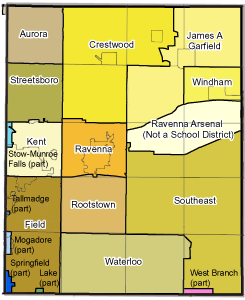
Portage County is home to eleven public school districts.| District | Location | Communities served |
|---|---|---|
| Aurora City School District | Aurora | Aurora, small part of Reminderville |
| Crestwood Local School District | Mantua | Mantua, Mantua Township, Hiram, most of Hiram Township, most of Shalersville Township |
| James A Garfield Local School District | Garrettsville | Garrettsville, Nelson Township, Freedom Township, part of Hiram Township, small part of Charlestown Township |
| Field Local School District | Brimfield | Brimfield Township, most of Suffield Township, parts of Tallmadge and Kent which were annexed from Brimfield |
| Kent City School District | Kent | Brady Lake, most of Kent, Sugar Bush Knolls, most of Franklin Township, small portion of Streetsboro |
| Ravenna School District | Ravenna | Ravenna, most of Ravenna Township, small portion of Shalersville Township |
| Rootstown Local School District Rootstown Local School District The Rootstown Local School District is a secondary school district located in Rootstown, Ohio, United States. The district serves approximately 1,300 students in Rootstown Township in Portage County and has three schools: Rootstown Elementary School serving grades K-5, Rootstown Middle School... |
Rootstown | Rootstown Township and small portion of Ravenna Township |
| Southeast Local School District | Palmyra | Edinburg Township, Palmyra Township, Paris Township, most of Charlestown Township, most of Deerfield Township |
| Streetsboro City School District | Streetsboro | most of Streetsboro |
| Waterloo Local School District | Atwater | Atwater Township, Randolph Township, small portion of Deerfield Township |
| Windham Exempted Village School District Windham Exempted Village School District The Windham Exempted Village School District is the public school district for the village of Windham and Windham Township in Portage County in the US state of Ohio. The district was founded as the Windham School Company by act of the Ohio Legislature on February 18, 1830... |
Windham | Windham, Windham Township |
| District | Location | Communities served in Portage County |
|---|---|---|
| Lake Local School District | Uniontown | small part of Suffield Township |
| Mogadore Local School District* | Mogadore | Mogadore, small part of Suffield Township |
| Springfield Local School District | Springfield Springfield Township, Summit County, Ohio Springfield Township is one of the nine townships of Summit County, Ohio, United States. The 2000 census found 15,168 people in the township.-Geography:Located in the southeastern part of the county, it borders the following townships and cities:... |
small part of Suffield Township |
| Stow-Munroe Falls City School District Stow-Munroe Falls City School District The Stow-Munroe Falls City School District is a public primary and secondary school district with administrative offices in Stow, Ohio. Located in eastern Summit County, the district serves more than 5,500 students—primarily from the cities of Stow and Munroe Falls—but also from neighboring... |
Stow | small part of Franklin Township |
| West Branch Local School District | Beloit | small part of Deerfield Township |
*= Although the village of Mogadore is located in both Summit and Portage Counties its school facilities are physically located in Summit County.
Higher education
Portage County is home to four institutions of higher learning:- Kent State UniversityKent State UniversityKent State University is a public research university located in Kent, Ohio, United States. The university has eight campuses around the northeast Ohio region with the main campus in Kent being the largest...
, located in KentKent, OhioKent is a city in the U.S. state of Ohio and the largest city in Portage County. It is located along the Cuyahoga River in Northeastern Ohio on the western edge of the county. The population was 27,906 at the 2000 United States Census and 28,904 in the 2010 Census...
; a large regional public research university with over 41,000 students. It serves as the county's largest employer.
- Hiram CollegeHiram CollegeHiram College is a private liberal arts college located in Hiram, Ohio. Founded by Amos Sutton Hayden of the Disciples of Christ Church in 1850, the institution has, since its first days, been nonsectarian and coeducational, and throughout its existence Hiram College has sustained this egalitarian...
, located in HiramHiram, OhioHiram is a village in Portage County, Ohio, United States. It was formed from portions of Hiram Township in the Connecticut Western Reserve. The population was 1,242 at the 2000 census...
in northwestern Portage County; a small liberal arts college of around 1,200 students.
- The Northeastern Ohio Universities College of Medicine and Pharmacy (NEOUCOM), located in RootstownRootstown Township, Portage County, OhioRootstown Township is one of the eighteen townships of Portage County, Ohio, United States. The 2000 census found 7,212 people in the township.-Geography:Located in the southwestern part of the county, it borders the following townships:...
, in the south-central part of the county. It serves students from Kent State, the University of AkronUniversity of AkronThe University of Akron is a coeducational public research university located in Akron, Ohio, United States. The university is part of the University System of Ohio. It was founded in 1870 as a small college affiliated with the Universalist Church. In 1913 ownership was transferred to the City of...
, Youngstown State UniversityYoungstown State UniversityYoungstown State University, founded in 1908, is an urban research university located in Youngstown, Ohio, United States. As of fall 2010, there were 15,194 students and a student-faculty ratio of 19:1. It is recognized as being one of the premier schools in the country, comparable to Ivy League...
, and Cleveland State UniversityCleveland State UniversityCleveland State University is a public university located in downtown Cleveland, Ohio. It was established in 1964 when the state of Ohio assumed control of Fenn College, and it absorbed the Cleveland-Marshall College of Law in 1969...
.
- A campus of Fortis CollegeFortis CollegeFortis College is a private post-secondary, for-profit institution that was established in 1969 and is operated by Education Affiliates. It was formerly Bohecker College, a sister school to the Centerville, Ohio Rets Technical Institute...
, a small two-year college of around 300 students in RavennaRavenna, Ohio* Chris Bangle; automobile designer* Bill Bower, last surviving pilot of the Doolittle Raid* David D. Busch; best-selling author* William Rufus Day; U.S. Supreme Court justice* Calvin Hampton; Classical organist* Robert B...
specializing in the business and medical technician fields.
See also
- National Register of Historic Places listings in Portage County, Ohio
- Ohio county governmentOhio county governmentOhio county government is the structure of official managerial and legal bodies of the counties of Ohio, USA. It is marked by a loose organization and a diffusion of power, the basic framework not having been changed since the Nineteenth century...