
Sandusky County, Ohio
Encyclopedia
Sandusky County is a county in the U.S. state
of Ohio
. As of the 2010 census
, the population was 60,944. http://quickfacts.census.gov/qfd/states/39/39143.html Its county seat
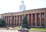
is Fremont
and it is named for a native word meaning "water" (Wyandot
: saundustee).
The Fremont Micropolitan Statistical Area includes all of Sandusky County.
, the county has a total area of 418 square miles (1,082.6 km²).409 square miles (1,060 km²) of it is land and 9 square miles (23.3 km²) of it (2.06%) is water.
of 2000, there were 61,792 people, 23,717 households, and 16,957 families residing in the county. The population density
was 151 people per square mile (58/km²). There were 25,253 housing units at an average density of 62 per square mile (24/km²). The racial makeup of the county was 92.20% White
, 2.67% Black
or African American
, 0.13% Native American
, 0.29% Asian
, 0.01% Pacific Islander
, 3.10% from other races
, and 1.61% from two or more races. 6.96% of the population were Hispanic
or Latino
of any race.
There were 23,717 households out of which 33.30% had children under the age of 18 living with them, 56.50% were married couples
living together, 10.50% had a female householder with no husband present, and 28.50% were non-families. 24.10% of all households were made up of individuals and 10.60% had someone living alone who was 65 years of age or older. The average household size was 2.56 and the average family size was 3.04.
In the county, the population was spread out with 26.20% under the age of 18, 8.10% from 18 to 24, 28.30% from 25 to 44, 23.00% from 45 to 64, and 14.50% who were 65 years of age or older. The median age was 37 years. For every 100 females there were 95.90 males. For every 100 females age 18 and over, there were 92.60 males.
The median income for a household in the county was $40,584, and the median income for a family was $47,675. Males had a median income of $35,501 versus $23,964 for females. The per capita income
for the county was $19,239. About 5.70% of families and 7.50% of the population were below the poverty line, including 9.10% of those under age 18 and 7.00% of those age 65 or over.

Sandusky County is a heavily Republican
County in Northwestern Ohio. The county has a strong history of supporting Republican presidential candidates as well as local Republican candidates. However, during the 2008 U.S. presidential election
, 51% of the voters from Sandusky County supported Democratic
candidate Barack Obama
.
U.S. state
A U.S. state is any one of the 50 federated states of the United States of America that share sovereignty with the federal government. Because of this shared sovereignty, an American is a citizen both of the federal entity and of his or her state of domicile. Four states use the official title of...
of Ohio
Ohio
Ohio is a Midwestern state in the United States. The 34th largest state by area in the U.S.,it is the 7th‑most populous with over 11.5 million residents, containing several major American cities and seven metropolitan areas with populations of 500,000 or more.The state's capital is Columbus...
. As of the 2010 census
United States Census, 2010
The Twenty-third United States Census, known as Census 2010 or the 2010 Census, is the current national census of the United States. National Census Day was April 1, 2010 and is the reference date used in enumerating individuals...
, the population was 60,944. http://quickfacts.census.gov/qfd/states/39/39143.html Its county seat
County seat
A county seat is an administrative center, or seat of government, for a county or civil parish. The term is primarily used in the United States....
is Fremont
Fremont, Ohio
Fremont Public Schools enroll 4,450 students in public primary and secondary schools. The district administers 9 public schools including seven elementary schools, one middle school, and one high school, Fremont Ross. In addition, the city is home to one private catholic high school, Saint Joseph...
and it is named for a native word meaning "water" (Wyandot
Wyandot language
Wyandot is the Iroquoian language traditionally spoken by the people known variously as Wyandot, Wyandotte, Wendat, or Huron. It was last spoken primarily in Oklahoma and Quebec...
: saundustee).
The Fremont Micropolitan Statistical Area includes all of Sandusky County.
Geography
According to the U.S. Census BureauUnited States Census Bureau
The United States Census Bureau is the government agency that is responsible for the United States Census. It also gathers other national demographic and economic data...
, the county has a total area of 418 square miles (1,082.6 km²).409 square miles (1,060 km²) of it is land and 9 square miles (23.3 km²) of it (2.06%) is water.
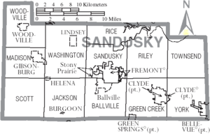
Adjacent counties
- Ottawa CountyOttawa County, OhioOttawa County is a county located in the state of Ohio, United States. As of the 2010 census, the population was 41,428. Its county seat is Port Clinton and is named either for the Ottawa Indians who lived there, or for an Indian word meaning "trader"....
(north) - Erie CountyErie County, OhioAs of the census of 2000, there were 79,551 people, 31,727 households, and 21,764 families residing in the county. The population density was 312 people per square mile . There were 35,909 housing units at an average density of 141 per square mile...
(east) - Huron CountyHuron County, OhioAs of the census of 2000, there were 59,487 people, 22,307 households, and 16,217 families residing in the county. The population density was 121 people per square mile . There were 23,594 housing units at an average density of 48 per square mile...
(southeast) - Seneca CountySeneca County, OhioSeneca County is a county located in the state of Ohio, United States. As of the 2010 census, the population was 56,745. Its county seat is Tiffin and it is named for the Seneca Indians.The Tiffin Micropolitan Statistical Area includes all of Seneca County....
(south) - Wood CountyWood County, OhioWood County is a county located in the state of Ohio, United States. As of the 2010 census, the population was 125,488. Its county seat is Bowling Green. The county was named for Captain Eleazer D. Wood, the engineer for General William Henry Harrison's army, who built Fort Meigs in the War of 1812...
(west)
History
Sandusky County was formed on February 12, 1820 from portions of Huron County. It was named after an Indian expression which roughly means "cold water".Demographics
As of the censusCensus
A census is the procedure of systematically acquiring and recording information about the members of a given population. It is a regularly occurring and official count of a particular population. The term is used mostly in connection with national population and housing censuses; other common...
of 2000, there were 61,792 people, 23,717 households, and 16,957 families residing in the county. The population density
Population density
Population density is a measurement of population per unit area or unit volume. It is frequently applied to living organisms, and particularly to humans...
was 151 people per square mile (58/km²). There were 25,253 housing units at an average density of 62 per square mile (24/km²). The racial makeup of the county was 92.20% White
Race (United States Census)
Race and ethnicity in the United States Census, as defined by the Federal Office of Management and Budget and the United States Census Bureau, are self-identification data items in which residents choose the race or races with which they most closely identify, and indicate whether or not they are...
, 2.67% Black
Race (United States Census)
Race and ethnicity in the United States Census, as defined by the Federal Office of Management and Budget and the United States Census Bureau, are self-identification data items in which residents choose the race or races with which they most closely identify, and indicate whether or not they are...
or African American
Race (United States Census)
Race and ethnicity in the United States Census, as defined by the Federal Office of Management and Budget and the United States Census Bureau, are self-identification data items in which residents choose the race or races with which they most closely identify, and indicate whether or not they are...
, 0.13% Native American
Race (United States Census)
Race and ethnicity in the United States Census, as defined by the Federal Office of Management and Budget and the United States Census Bureau, are self-identification data items in which residents choose the race or races with which they most closely identify, and indicate whether or not they are...
, 0.29% Asian
Race (United States Census)
Race and ethnicity in the United States Census, as defined by the Federal Office of Management and Budget and the United States Census Bureau, are self-identification data items in which residents choose the race or races with which they most closely identify, and indicate whether or not they are...
, 0.01% Pacific Islander
Race (United States Census)
Race and ethnicity in the United States Census, as defined by the Federal Office of Management and Budget and the United States Census Bureau, are self-identification data items in which residents choose the race or races with which they most closely identify, and indicate whether or not they are...
, 3.10% from other races
Race (United States Census)
Race and ethnicity in the United States Census, as defined by the Federal Office of Management and Budget and the United States Census Bureau, are self-identification data items in which residents choose the race or races with which they most closely identify, and indicate whether or not they are...
, and 1.61% from two or more races. 6.96% of the population were Hispanic
Race (United States Census)
Race and ethnicity in the United States Census, as defined by the Federal Office of Management and Budget and the United States Census Bureau, are self-identification data items in which residents choose the race or races with which they most closely identify, and indicate whether or not they are...
or Latino
Race (United States Census)
Race and ethnicity in the United States Census, as defined by the Federal Office of Management and Budget and the United States Census Bureau, are self-identification data items in which residents choose the race or races with which they most closely identify, and indicate whether or not they are...
of any race.
There were 23,717 households out of which 33.30% had children under the age of 18 living with them, 56.50% were married couples
Marriage
Marriage is a social union or legal contract between people that creates kinship. It is an institution in which interpersonal relationships, usually intimate and sexual, are acknowledged in a variety of ways, depending on the culture or subculture in which it is found...
living together, 10.50% had a female householder with no husband present, and 28.50% were non-families. 24.10% of all households were made up of individuals and 10.60% had someone living alone who was 65 years of age or older. The average household size was 2.56 and the average family size was 3.04.
In the county, the population was spread out with 26.20% under the age of 18, 8.10% from 18 to 24, 28.30% from 25 to 44, 23.00% from 45 to 64, and 14.50% who were 65 years of age or older. The median age was 37 years. For every 100 females there were 95.90 males. For every 100 females age 18 and over, there were 92.60 males.
The median income for a household in the county was $40,584, and the median income for a family was $47,675. Males had a median income of $35,501 versus $23,964 for females. The per capita income
Per capita income
Per capita income or income per person is a measure of mean income within an economic aggregate, such as a country or city. It is calculated by taking a measure of all sources of income in the aggregate and dividing it by the total population...
for the county was $19,239. About 5.70% of families and 7.50% of the population were below the poverty line, including 9.10% of those under age 18 and 7.00% of those age 65 or over.
Government
Sandusky County is a heavily Republican
Republican Party (United States)
The Republican Party is one of the two major contemporary political parties in the United States, along with the Democratic Party. Founded by anti-slavery expansion activists in 1854, it is often called the GOP . The party's platform generally reflects American conservatism in the U.S...
County in Northwestern Ohio. The county has a strong history of supporting Republican presidential candidates as well as local Republican candidates. However, during the 2008 U.S. presidential election
United States presidential election, 2008
The United States presidential election of 2008 was the 56th quadrennial presidential election. It was held on November 4, 2008. Democrat Barack Obama, then the junior United States Senator from Illinois, defeated Republican John McCain, the senior U.S. Senator from Arizona. Obama received 365...
, 51% of the voters from Sandusky County supported Democratic
Democratic Party (United States)
The Democratic Party is one of two major contemporary political parties in the United States, along with the Republican Party. The party's socially liberal and progressive platform is largely considered center-left in the U.S. political spectrum. The party has the lengthiest record of continuous...
candidate Barack Obama
Barack Obama
Barack Hussein Obama II is the 44th and current President of the United States. He is the first African American to hold the office. Obama previously served as a United States Senator from Illinois, from January 2005 until he resigned following his victory in the 2008 presidential election.Born in...
.
Current Sandusky County office holders
| Office | Name | Party |
|---|---|---|
| Commissioner | Terry Thatcher | Republican |
| Commissioner | John Rettig | Republican |
| Commissioner | Dan Polter | |
| Prosecutor | Tom Stierwalt | Democrat |
| Sheriff | Kyle Overmyer | Republican |
| Clerk of Courts | Warren Brown | Republican |
| Recorder | Colleen Carmack | Republican |
| Treasurer | Irma Celestino | Republican |
| Engineer | James Moyer | Republican |
| Coroner | John Wukie | Republican |
| Auditor | William Farrell | Democrat |
| Common Pleas Court Judge | John Dewey | |
| Common Pleas Court Judge | Barbara Ansted | Republican |
| County Courts Judge | Herbert Adams | |
| County Courts Judge | John Kolesar | |
| Juvenile Court Judge | Brad Smith |
Communities
Villages
|
Helena, Ohio Helena is a village in Sandusky County, Ohio, United States. The population was 236 at the 2000 census.-Geography:Helena is located at .According to the United States Census Bureau, the village has a total area of , all of it land.... Lindsey, Ohio Lindsey is a village in Sandusky County, Ohio, United States. The population was 504 at the 2000 census. The National Arbor Day Foundation has designated Lindsey as a Tree City USA.-Geography:Lindsey is located at .... Woodville, Ohio Woodville is a village in Sandusky County, Ohio, United States. The population was 1,977 at the 2000 census. The National Arbor Day Foundation has designated Woodville as a Tree City USA.-History:... |
Townships
|
Rice Township, Sandusky County, Ohio Rice Township is one of the twelve townships of Sandusky County, Ohio, United States. As of the 2000 census, 1,437 people lived in the township.-Geography:Located in the northern part of the county along Sandusky Bay, it borders the following townships:... Riley Township, Sandusky County, Ohio Riley Township is one of the twelve townships of Sandusky County, Ohio, United States. As of the 2000 census, 1,302 people lived in the township.-Geography:... Sandusky Township, Sandusky County, Ohio Sandusky Township is one of the twelve townships of Sandusky County, Ohio, United States. As of the 2000 census, 4,087 people lived in the unincorporated portions of the township.-Geography:... Scott Township, Sandusky County, Ohio Scott Township is one of the twelve townships of Sandusky County, Ohio, United States. As of the 2000 census, 1,502 people lived in the township.-Geography:Located in the southeastern corner of the county, it borders the following townships:... |
Townsend Township, Sandusky County, Ohio Townsend Township is one of the twelve townships of Sandusky County, Ohio, United States. As of the 2000 census, 1,670 people lived in the township.-Geography:Located in the northeastern corner of the county, it borders the following townships:... Washington Township, Sandusky County, Ohio Washington Township is one of the twelve townships of Sandusky County, Ohio, United States. As of the 2000 census, 2,396 people lived in the township, 1,769 of whom lived in the unincorporated portions of the township.-Geography:... Woodville Township, Sandusky County, Ohio Woodville Township is one of the twelve townships of Sandusky County, Ohio, United States. As of the 2000 census, 3,304 people lived in the township, 1,327 of whom lived in the unincorporated portions of the township.-Geography:... York Township, Sandusky County, Ohio York Township is one of the twelve townships of Sandusky County, Ohio, United States. As of the 2000 census, 2,512 people lived in the township.-Geography:Located in the southeastern corner of the county, it borders the following townships:... |
Other communities
|
|
Millersville, Ohio Millersville is an unincorporated community in northwestern Jackson Township, Sandusky County, Ohio, United States, within the Toledo Metropolitan Area. It lies at the intersection of Millersville Road and the Greensburg Pike. Muddy Creek, which flows into Sandusky Bay near the mouth of the... Rollersville, Ohio Rollersville is an unincorporated community on the border between Madison and Scott townships in Sandusky County, Ohio, United States. It is located on the Grand Army of the Republic Highway , approximately west of Helena, Ohio. Rollersville had a post office from 1839 to 1908.-References:... |
Vickery, Ohio Vickery is an unincorporated community in western Townsend Township, Sandusky County, Ohio, United States. Although it is unincorporated, it has a post office, with the ZIP code of 43464 and a volunteer fire department called Townsend Township FD.... |
Major highways
|


Other highways
|
 Ohio State Route 101 Ohio State Route 101 Ohio State Route 105 Ohio State Route 105 Ohio State Route 300 Ohio State Route 300 Ohio State Route 412 Ohio State Route 412 Ohio State Route 510 Ohio State Route 510Ohio State Route 510 State Route 510 ' is a north–south state highway in the northern portion of Ohio. The entirety of State Route 510 lies within Sandusky County. Its southern terminus is at State Route 101 in Clyde, and its northern terminus is at U.S. Route 6 between Fremont and Sandusky.-Route... |
 Ohio State Route 523 Ohio State Route 523Ohio State Route 523 Ohio State Route 523 ' is a state highway in North Central Ohio. A short connector route, OH 523 links OH 19 at its western terminus with OH 53 at its eastern terminus...  Ohio State Route 582 Ohio State Route 582 Ohio State Route 590 Ohio State Route 590 Ohio State Route 600 Ohio State Route 600 Ohio State Route 635 Ohio State Route 635 |
 Ohio State Route 12
 Ohio State Route 18
 Ohio State Route 19
 Ohio State Route 51
 Ohio State Route 53
Places of interest
- H. J. Heinz CompanyH. J. Heinz CompanyThe H. J. Heinz Company , commonly known as Heinz and famous for its "57 Varieties" slogan and its ketchup, is an American food company with world headquarters in Pittsburgh, Pennsylvania.Perhaps best known for its ketchup, the H.J...
ketchupKetchupKetchup is a sweet-and-tangy condiment typically made from tomatoes, vinegar, sugar or high-fructose corn syrup and an assortment of...
factory (the world's largest) - Mineral Springs at Green Springs, Ohio
- Rutherford B. Hayes Presidential CenterRutherford B. Hayes Presidential CenterThe Rutherford B. Hayes Presidential Center is a complex comprising several buildings related to the life and presidency of Rutherford B. Hayes. Located in Fremont, Ohio, the center comprises the Rutherford B. Hayes Museum and Library and Spiegel Grove, an estate encompassing the Hayes home,...
- Spiegel GroveSpiegel GroveSpiegel Grove, also known as Spiegel Grove State Park, Rutherford B. Hayes House, Rutherford B. Hayes Summer Home and Rutherford B. Hayes State Memorial is an historic site that was the estate of Civil War general and nineteenth President of the United States Rutherford B Hayes. It is located at...
- Fremont SpeedwayFremont SpeedwayFremont Speedway, also known as The Track That Action Built and Home of the All Stars, is a semi-banked 1/3 mile clay oval speedway located at the Sandusky County Fairgrounds in Fremont, Ohio, USA. Races are typically held on Saturday nights. Regular events include 410 cubic inch sprint cars, 305...