

Greene County, Ohio
Encyclopedia
Greene County is a county located in the state
of Ohio
, United States
. The population was 161,573 in the 2010 Census
. Its county seat
is Xenia
, and it was named for General Nathanael Greene
, an officer in the Revolutionary War
. Greene County was established on March 24, 1803.
Greene County is part of the Dayton Metropolitan Statistical Area.
, the county has a total area of 416 square miles (1,077.4 km²). 415 square miles (1,074.8 km²) is land and 1 square miles (2.6 km²) (0.32%) is water.
of 2010, there were 161,573 people, 61,825 households, and 39,160 families residing in the county. The population density
was 356 people per square mile (138/km²). There were 58,224 housing units at an average density of 140 per square mile (54/km²). The racial makeup of the county was 86.4% White
, 7.2% Black
or African American
, 0.3% Native American
, 2.9% Asian
, 0.1% Pacific Islander
, 0.38% from other races
, and 1.66% from two or more races. 1.23% of the population were Hispanic
or Latino
of any race.
There were 55,312 households out of which 32.80% had children under the age of 18 living with them, 58.00% were married couples
living together, 9.60% had a female householder with no husband present, and 29.20% were non-families. 23.00% of all households were made up of individuals and 7.70% had someone living alone who was 65 years of age or older. The average household size was 2.53 and the average family size was 3.00.
In the county the population was spread out with 23.90% under the age of 18, 13.70% from 18 to 24, 27.00% from 25 to 44, 23.60% from 45 to 64, and 11.80% who were 65 years of age or older. The median age was 36 years. For every 100 females there were 94.80 males. For every 100 females age 18 and over, there were 91.40 males.
The median income for a household in the county was $48,656, and the median income for a family was $57,954. Males had a median income of $42,338 versus $28,457 for females. The per capita income
for the county was $23,057. About 5.20% of families and 8.50% of the population were below the poverty line, including 8.70% of those under age 18 and 6.90% of those age 65 or over.
Marilyn Reid, (R)
Richard Perales, (R)
Alan Anderson (R)
U.S. state
A U.S. state is any one of the 50 federated states of the United States of America that share sovereignty with the federal government. Because of this shared sovereignty, an American is a citizen both of the federal entity and of his or her state of domicile. Four states use the official title of...
of Ohio
Ohio
Ohio is a Midwestern state in the United States. The 34th largest state by area in the U.S.,it is the 7th‑most populous with over 11.5 million residents, containing several major American cities and seven metropolitan areas with populations of 500,000 or more.The state's capital is Columbus...
, United States
United States
The United States of America is a federal constitutional republic comprising fifty states and a federal district...
. The population was 161,573 in the 2010 Census
2010 census
The following countries conducted a census in 2010:* Sixth National Population Census of the People's Republic of China* Russian Census * 2010 United States Census...
. Its county seat
County seat
A county seat is an administrative center, or seat of government, for a county or civil parish. The term is primarily used in the United States....
is Xenia
Xenia, Ohio
Xenia is a city in and the county seat of Greene County, Ohio, United States. The municipality is located in southwestern Ohio 21 miles from Dayton and is part of the Dayton Metropolitan Statistical Area...
, and it was named for General Nathanael Greene
Nathanael Greene
Nathanael Greene was a major general of the Continental Army in the American Revolutionary War. When the war began, Greene was a militia private, the lowest rank possible; he emerged from the war with a reputation as George Washington's most gifted and dependable officer. Many places in the United...
, an officer in the Revolutionary War
American Revolutionary War
The American Revolutionary War , the American War of Independence, or simply the Revolutionary War, began as a war between the Kingdom of Great Britain and thirteen British colonies in North America, and ended in a global war between several European great powers.The war was the result of the...
. Greene County was established on March 24, 1803.
Greene County is part of the Dayton Metropolitan Statistical Area.
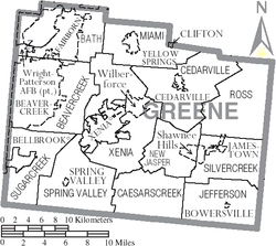
Geography
According to the U.S. Census BureauUnited States Census Bureau
The United States Census Bureau is the government agency that is responsible for the United States Census. It also gathers other national demographic and economic data...
, the county has a total area of 416 square miles (1,077.4 km²). 415 square miles (1,074.8 km²) is land and 1 square miles (2.6 km²) (0.32%) is water.
Adjacent counties
- Clark County, OhioClark County, OhioAs of the census of 2000, there were 144,742 people, 56,648 households, and 39,370 families residing in the county. The population density was 362 people per square mile . There were 61,056 housing units at an average density of 153 per square mile...
- north - Madison County, OhioMadison County, OhioAs of the census of 2000, there were 40,213 people, 13,672 households, and 10,035 families residing in the county. The population density was 86 people per square mile . There were 14,399 housing units at an average density of 31 per square mile...
- northeast - Fayette County, OhioFayette County, OhioAs of the census of 2000, there were 28,433 people, 11,054 households, and 7,837 families residing in the county. The population density was 70 people per square mile . There were 11,904 housing units at an average density of 29 per square mile...
- southeast - Clinton County, OhioClinton County, OhioClinton County is a county located in the state of Ohio, United States. As of the 2010 census, the population was 42,040. The 2008 Census Population Estimate places the figure at 43,200. It is named for former U.S. Vice-President George Clinton...
- south - Warren County, OhioWarren County, OhioWarren County is a county located in the state of Ohio, United States. The population was 212,693 at the 2010 census. Its county seat is Lebanon. Warren County was erected May 1, 1803, from Hamilton County, and named for Dr...
- southwest - Montgomery County, OhioMontgomery County, OhioMontgomery County is a county located in the state of Ohio, United States. The population was 535,153 in the 2010 Census. It was named in honor of Richard Montgomery, an American Revolutionary War general killed in 1775 while attempting to capture Quebec City, Canada. The county seat is Dayton...
- west
Demographics
As of the censusCensus
A census is the procedure of systematically acquiring and recording information about the members of a given population. It is a regularly occurring and official count of a particular population. The term is used mostly in connection with national population and housing censuses; other common...
of 2010, there were 161,573 people, 61,825 households, and 39,160 families residing in the county. The population density
Population density
Population density is a measurement of population per unit area or unit volume. It is frequently applied to living organisms, and particularly to humans...
was 356 people per square mile (138/km²). There were 58,224 housing units at an average density of 140 per square mile (54/km²). The racial makeup of the county was 86.4% White
Race (United States Census)
Race and ethnicity in the United States Census, as defined by the Federal Office of Management and Budget and the United States Census Bureau, are self-identification data items in which residents choose the race or races with which they most closely identify, and indicate whether or not they are...
, 7.2% Black
Race (United States Census)
Race and ethnicity in the United States Census, as defined by the Federal Office of Management and Budget and the United States Census Bureau, are self-identification data items in which residents choose the race or races with which they most closely identify, and indicate whether or not they are...
or African American
Race (United States Census)
Race and ethnicity in the United States Census, as defined by the Federal Office of Management and Budget and the United States Census Bureau, are self-identification data items in which residents choose the race or races with which they most closely identify, and indicate whether or not they are...
, 0.3% Native American
Race (United States Census)
Race and ethnicity in the United States Census, as defined by the Federal Office of Management and Budget and the United States Census Bureau, are self-identification data items in which residents choose the race or races with which they most closely identify, and indicate whether or not they are...
, 2.9% Asian
Race (United States Census)
Race and ethnicity in the United States Census, as defined by the Federal Office of Management and Budget and the United States Census Bureau, are self-identification data items in which residents choose the race or races with which they most closely identify, and indicate whether or not they are...
, 0.1% Pacific Islander
Race (United States Census)
Race and ethnicity in the United States Census, as defined by the Federal Office of Management and Budget and the United States Census Bureau, are self-identification data items in which residents choose the race or races with which they most closely identify, and indicate whether or not they are...
, 0.38% from other races
Race (United States Census)
Race and ethnicity in the United States Census, as defined by the Federal Office of Management and Budget and the United States Census Bureau, are self-identification data items in which residents choose the race or races with which they most closely identify, and indicate whether or not they are...
, and 1.66% from two or more races. 1.23% of the population were Hispanic
Race (United States Census)
Race and ethnicity in the United States Census, as defined by the Federal Office of Management and Budget and the United States Census Bureau, are self-identification data items in which residents choose the race or races with which they most closely identify, and indicate whether or not they are...
or Latino
Race (United States Census)
Race and ethnicity in the United States Census, as defined by the Federal Office of Management and Budget and the United States Census Bureau, are self-identification data items in which residents choose the race or races with which they most closely identify, and indicate whether or not they are...
of any race.
There were 55,312 households out of which 32.80% had children under the age of 18 living with them, 58.00% were married couples
Marriage
Marriage is a social union or legal contract between people that creates kinship. It is an institution in which interpersonal relationships, usually intimate and sexual, are acknowledged in a variety of ways, depending on the culture or subculture in which it is found...
living together, 9.60% had a female householder with no husband present, and 29.20% were non-families. 23.00% of all households were made up of individuals and 7.70% had someone living alone who was 65 years of age or older. The average household size was 2.53 and the average family size was 3.00.
In the county the population was spread out with 23.90% under the age of 18, 13.70% from 18 to 24, 27.00% from 25 to 44, 23.60% from 45 to 64, and 11.80% who were 65 years of age or older. The median age was 36 years. For every 100 females there were 94.80 males. For every 100 females age 18 and over, there were 91.40 males.
The median income for a household in the county was $48,656, and the median income for a family was $57,954. Males had a median income of $42,338 versus $28,457 for females. The per capita income
Per capita income
Per capita income or income per person is a measure of mean income within an economic aggregate, such as a country or city. It is calculated by taking a measure of all sources of income in the aggregate and dividing it by the total population...
for the county was $23,057. About 5.20% of families and 8.50% of the population were below the poverty line, including 8.70% of those under age 18 and 6.90% of those age 65 or over.
Government
Greene County has 3 County Commissioners that oversee the various County departments. Current Commissioners are:Marilyn Reid, (R)
Republican Party (United States)
The Republican Party is one of the two major contemporary political parties in the United States, along with the Democratic Party. Founded by anti-slavery expansion activists in 1854, it is often called the GOP . The party's platform generally reflects American conservatism in the U.S...
Richard Perales, (R)
Republican Party (United States)
The Republican Party is one of the two major contemporary political parties in the United States, along with the Democratic Party. Founded by anti-slavery expansion activists in 1854, it is often called the GOP . The party's platform generally reflects American conservatism in the U.S...
Alan Anderson (R)
Republican Party (United States)
The Republican Party is one of the two major contemporary political parties in the United States, along with the Democratic Party. Founded by anti-slavery expansion activists in 1854, it is often called the GOP . The party's platform generally reflects American conservatism in the U.S...
Communities
Cities
|
Huber Heights, Ohio Huber Heights is a city in Montgomery, Miami, and Greene Counties in the U.S. state of Ohio. Huber Heights's motto is "America's largest community of brick homes." The city is named for Charles Huber, the developer who constructed a number of the houses that would later comprise the city. Suburban... (part, one parcel). Kettering, Ohio As of the census of 2000, there were 57,502 people, 25,657 households, and 15,727 families residing in the city. The population density was 3,077.4 people per square mile . There were 26,936 housing units at an average density of 1,441.6 per square mile... (part) Xenia, Ohio Xenia is a city in and the county seat of Greene County, Ohio, United States. The municipality is located in southwestern Ohio 21 miles from Dayton and is part of the Dayton Metropolitan Statistical Area... |
Villages
|
Jamestown, Ohio Jamestown is a village in Greene County, Ohio, United States. The population was 1,917 at the 2000 census. It is named after Jamestown, Virginia, the hometown of an early resident.... Spring Valley, Ohio Spring Valley is a village in Greene County, Ohio, United States. The population was 551 at the 2010 census. It is part of the Dayton Metropolitan Statistical Area.-Geography:Spring Valley is located at .... Yellow Springs, Ohio Yellow Springs is a village in Greene County, Ohio, United States, and is the location of Antioch College and Antioch University Midwest. The population was 3,487 at the 2010 census... |
Townships
|
Jefferson Township, Greene County, Ohio Jefferson Township is one of the twelve townships of Greene County, Ohio, United States. The 2000 census found 1,109 people in the township, 819 of whom lived in the unincorporated portions of the township.-Geography:... Miami Township, Greene County, Ohio Miami Township is one of the twelve townships of Greene County, Ohio, United States. The 2000 census found 5,106 people in the township, 1,215 of whom lived in the unincorporated portions of the township.-Geography:... New Jasper Township, Greene County, Ohio New Jasper Township is one of the twelve townships of Greene County, Ohio, United States. The 2000 census found 2,538 people in the township.-Geography:Located in the east central part of the county, it borders the following townships:... Ross Township, Greene County, Ohio Ross Township is one of the twelve townships of Greene County, Ohio, United States. The 2000 census found 744 people in the township.-Geography:Located in the northeastern corner of the county, it borders the following townships:... |
Silvercreek Township, Greene County, Ohio Silvercreek Township is one of the twelve townships of Greene County, Ohio, United States. The 2000 census found 3,688 people in the township, 1,771 of whom lived in the unincorporated portions of the township.-Geography:... Spring Valley Township, Greene County, Ohio Spring Valley Township is one of the twelve townships of Greene County, Ohio, United States. The 2000 census found 2,489 people in the township, 1,979 of whom lived in the unincorporated portions of the township.-Geography:... Xenia Township, Greene County, Ohio Xenia Township is one of the twelve townships of Greene County, Ohio, United States. The 2000 census found 6,117 people in the township.-Geography:Located at the center of the county, it borders the following townships:*Miami Township - north... |
Census-designated places
- Shawnee HillsShawnee Hills, Greene County, OhioShawnee Hills is a census-designated place in Greene County, Ohio, United States. The population was 2,355 at the 2000 census. It is part of the Dayton Metropolitan Statistical Area.-Geography:Shawnee Hills is located at ....
- WilberforceWilberforce, OhioWilberforce is a census-designated place in Greene County, Ohio, United States. The population was 1,579 at the 2000 census. The community was named for the English statesman William Wilberforce, who worked for abolition of slavery and achieved the end of the slave trade in the United Kingdom and...
- Wright-Patterson Air Force BaseWright-Patterson Air Force BaseWright-Patterson Air Force Base is a United States Air Force base in Greene and Montgomery counties in the state of Ohio. It includes both Wright and Patterson Fields, which were originally Wilbur Wright Field and Fairfield Aviation General Supply Depot. Patterson Field is located approximately...
Public
- Wright State UniversityWright State UniversityWright State University is a comprehensive public university with strong doctoral, research, and undergraduate programs, rated among the 260 Best National Universities listed in the annual "America's Best Colleges" rankings by U.S. News and World Report. Wright State is located in Fairborn, Ohio,...
, Fairborn - Central State UniversityCentral State UniversityCentral State University, commonly referred to as "C-State", is a historically black university located in Wilberforce, Ohio, United States. It is the only public HBCU in Ohio.-History:...
, Wilberforce - Clark State Community CollegeClark State Community CollegeClark State Community College began in 1962 as the Springfield and Clark County Technical Education Program in an effort to meet the post-secondary, technical education needs of Springfield and the surrounding area. In 1966 the name was changed to Clark County Technical Institute and was chartered...
- Greene Center, Beavercreek
Private
- Antioch CollegeAntioch CollegeAntioch College is a private, independent liberal arts college in Yellow Springs, Ohio, United States. It was the founder and the flagship institution of the six-campus Antioch University system. Founded in 1852 by the Christian Connection, the college began operating in 1853 with politician and...
, Yellow Springs - Wilberforce UniversityWilberforce UniversityWilberforce University is a private, coed, liberal arts historically black university located in Wilberforce, Ohio. Affiliated with the African Methodist Episcopal Church, it was the first college to be owned and operated by African Americans...
, Wilberforce - Cedarville UniversityCedarville UniversityCedarville University is a private, co-educational liberal arts university located in Cedarville, Ohio.At its founding, the school was affiliated with the conservative General Synod of the Reformed Presbyterian Church in North America. Today, Cedarville is a Southern Baptist school known for its...
, Cedarville
Public schools
- Beavercreek City School DistrictBeavercreek City School DistrictBeavercreek City School District is located in Beavercreek, Ohio southeast of Dayton. The district contains 1 high school, 2 middle schools, and 5 elementary schools. Nick Verhoff is the district superintendent.-Elementary Schools:...
- Beavercreek High SchoolBeavercreek High SchoolBeavercreek High School is a public high school for grades 9-12 located in Beavercreek, Ohio. The principal is Marian West. It is a member of the Beavercreek City School District and is the only high school in the district. Beavercreek High School is located in a suburban setting...
, Beavercreek (the Beavers)
- Beavercreek High School
- Cedar Cliff Local School District
- Cedarville High School, CedarvilleCedarville, OhioCedarville is a village in Greene County, Ohio, United States. The population was 3,828 at the 2000 census. It is the home of Cedarville University and Cedarville High School.Cedarville is part of the Dayton Metropolitan Statistical Area...
(the Indians)
- Cedarville High School, Cedarville
- Fairborn City School District
- Fairborn High SchoolFairborn High SchoolFairborn High School is a public high school for grades 9-12 in Fairborn, Ohio. It is the only high school in the Fairborn City Schools district. Its mascot is the Skyhawk. The school has approximately 1600 students.-History:...
, FairbornFairborn, OhioFairborn is a city in Greene County, Ohio, United States, near Dayton and Wright-Patterson Air Force Base. The population was 32,352 at the 2010 census...
(the Skyhawks)
- Fairborn High School
- Greeneview Local School District
- Greeneview High SchoolGreeneview High SchoolGreeneview High School is a public high school in Jamestown, Ohio. It is the only high school in the Greeneview Local School District. Their mascot is the Ram.-Ohio High School Athletic Association State Championships:* Boys Soccer – 2005...
, JamestownJamestown, OhioJamestown is a village in Greene County, Ohio, United States. The population was 1,917 at the 2000 census. It is named after Jamestown, Virginia, the hometown of an early resident....
(the Rams)
- Greeneview High School
- Sugarcreek Local School District
- Bellbrook High SchoolBellbrook High SchoolBellbrook High School is a public high school in Sugarcreek Township, Ohio / Bellbrook, Ohio area. It is the four year high school of the Bellbrook - Sugarcreek Local School District, which is rated Excellent by the Ohio Department of Education. The school serves grades 9–12. Their mascot is the...
, BellbrookBellbrook, OhioBellbrook is a city in Greene County, Ohio, United States. The population was 6,943 at the 2010 census. It is part of the Dayton Metropolitan Statistical Area.-History:Bellbrook was first settled in 1814...
(the Golden Eagles)
- Bellbrook High School
- Xenia Community City School District
- Xenia High SchoolXenia High SchoolXenia High School is a public high school in Xenia, Ohio. It is the only high school in the Xenia Community Schools district. The school's average daily student enrollment for the 2008-2009 school year was 1452. The Ohio Department of Education has given Xenia High School a rating of "Continuous...
, XeniaXenia, OhioXenia is a city in and the county seat of Greene County, Ohio, United States. The municipality is located in southwestern Ohio 21 miles from Dayton and is part of the Dayton Metropolitan Statistical Area...
(the Buccaneers)
- Xenia High School
- Yellow Springs Exempted Village School District
- Yellow Springs High SchoolYellow Springs High SchoolYellow Springs High School is a public high school in Yellow Springs, Ohio. It is the only high school in the Yellow Springs Exempted Village Schools district, teaching grades 9-12. McKinney Middle School is the district's only secondary school, teaching grades 7 & 8. Mills Lawn Elementary is the...
, Yellow SpringsYellow Springs, OhioYellow Springs is a village in Greene County, Ohio, United States, and is the location of Antioch College and Antioch University Midwest. The population was 3,487 at the 2010 census...
(the Bulldogs)
- Yellow Springs High School
- Greene County Career Center, Xenia (Vocational schoolVocational schoolA vocational school , providing vocational education, is a school in which students are taught the skills needed to perform a particular job...
)
Private schools
- Dayton Christian School SystemDayton Christian School SystemDayton Christian School System is a private, nondenominational Christian school district located in southwestern Ohio. There are two campuses: the Dayton campus in Miamisburg, Ohio and the Xenia campus in Xenia, Ohio. There is also a homeschool program....
- Xenia Christian High SchoolXenia Christian High SchoolXenia Christian High School is a private, Christian high school in Xenia, Ohio. It is one of two high schools run by the Dayton Christian School System. Xenia Christian High School includes grades 9-12. Dayton Christian School System added Xenia Christian Elementary and High School in 1993 and...
, XeniaXenia, OhioXenia is a city in and the county seat of Greene County, Ohio, United States. The municipality is located in southwestern Ohio 21 miles from Dayton and is part of the Dayton Metropolitan Statistical Area...
(the Ambassadors)
- Xenia Christian High School