

Stark County, Ohio
Encyclopedia
Stark County is a county located in the U.S. state
of Ohio
. As of the 2010 census, the population was 375,586. http://quickfacts.census.gov/qfd/states/39/39151.html It is included in the Canton-Massillon, Ohio
Metropolitan Statistical Area
.
It is named for John Stark
, an officer in the American Revolutionary War
. Its county seat
is Canton
.
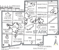
, the county has a total area of 581 square miles (1,504.8 km²).576 square miles (1,492 km²) of it is land and 5 square miles (12.9 km²) of it (0.82%) is water.
Stark County, Ohio, is one of the few counties in the United States to border as many as eight counties.
General John Stark
. John Stark (August 28, 1728 – May 8, 1822) was a general who served in the American Continental Army during the American Revolutionary War. He became widely known as the "Hero of Bennington" for his exemplary service at the Battle of Bennington in 1777.
In the later 20th century, Stark County's voting record swung from one party to another, closely tracking the winner of the U.S. Presidential election
. Even within the swing state
of Ohio
, Stark County is regarded as a quintessential bellwether
, and thus presidential candidates have typically made multiple visits to the region. Major media
outlets typically pay close attention to the election results in the county. The New York Times in particular has covered the county's citizens and their voting concerns in a series of features each election cycle for over a decade.
of 2000, there were 378,098 people, 148,316 households, and 102,782 families residing in the county. The population density
was 656 people per square mile (253/km²). There were 157,024 housing units at an average density of 272 per square mile (105/km²). The racial makeup of the county was 90.28% White
, 7.20% Black
or African American
, 0.24% Native American
, 0.54% Asian
, 0.02% Pacific Islander
, 0.29% from other races
, and 1.43% from two or more races. 0.92% of the population were Hispanic
or Latino
of any race.
There were 148,316 households out of which 31.00% had children under the age of 18 living with them, 54.20% were married couples
living together, 11.50% had a female householder with no husband present, and 30.70% were non-families. 26.10% of all households were made up of individuals and 10.90% had someone living alone who was 65 years of age or older. The average household size was 2.49 and the average family size was 3.00.
In the county, the population was spread out with 24.80% under the age of 18, 8.30% from 18 to 24, 27.80% from 25 to 44, 24.00% from 45 to 64, and 15.10% who were 65 years of age or older. The median age was 38 years. For every 100 females there were 92.40 males. For every 100 females age 18 and over, there were 88.40 males.
The median income for a household in the county was $39,824, and the median income for a family was $47,747. Males had a median income of $37,065 versus $23,875 for females. The per capita income
for the county was $20,417. About 6.80% of families and 9.20% of the population were below the poverty line, including 12.90% of those under age 18 and 6.60% of those age 65 or over.
U.S. state
A U.S. state is any one of the 50 federated states of the United States of America that share sovereignty with the federal government. Because of this shared sovereignty, an American is a citizen both of the federal entity and of his or her state of domicile. Four states use the official title of...
of Ohio
Ohio
Ohio is a Midwestern state in the United States. The 34th largest state by area in the U.S.,it is the 7th‑most populous with over 11.5 million residents, containing several major American cities and seven metropolitan areas with populations of 500,000 or more.The state's capital is Columbus...
. As of the 2010 census, the population was 375,586. http://quickfacts.census.gov/qfd/states/39/39151.html It is included in the Canton-Massillon, Ohio
Massillon, Ohio
Massillon is a city located in Stark County in the U.S. state of Ohio, approximately 8 miles to the west of Canton, Ohio, 20 miles south of Akron, Ohio, and 50 miles south of Cleveland, Ohio. The population was 32,149 at the 2010 census....
Metropolitan Statistical Area
Canton-Massillon metropolitan area
The Canton–Massillon Metropolitan Statistical Area, as defined by the United States Census Bureau, is an area consisting of two counties in northeastern Ohio, anchored by the cities of Canton and Massillon...
.
It is named for John Stark
John Stark
John Stark was a New Hampshire native who served as a major general in the Continental Army during the American Revolution. He became widely known as the "Hero of Bennington" for his exemplary service at the Battle of Bennington in 1777.-Early life:John Stark was born in Londonderry, New...
, an officer in the American Revolutionary War
American Revolutionary War
The American Revolutionary War , the American War of Independence, or simply the Revolutionary War, began as a war between the Kingdom of Great Britain and thirteen British colonies in North America, and ended in a global war between several European great powers.The war was the result of the...
. Its county seat
County seat
A county seat is an administrative center, or seat of government, for a county or civil parish. The term is primarily used in the United States....
is Canton
Canton, Ohio
Canton is the county seat of Stark County in northeastern Ohio, approximately south of Akron and south of Cleveland.The City of Caton is the largest incorporated area within the Canton-Massillon Metropolitan Statistical Area...
.
Geography
According to the U.S. Census BureauUnited States Census Bureau
The United States Census Bureau is the government agency that is responsible for the United States Census. It also gathers other national demographic and economic data...
, the county has a total area of 581 square miles (1,504.8 km²).576 square miles (1,492 km²) of it is land and 5 square miles (12.9 km²) of it (0.82%) is water.
Adjacent counties
- Portage CountyPortage County, OhioPortage County is a county located in the U.S. state of Ohio. The population was 152,061 at the 2000 Census and 161,419 at the 2010 Census. Its county seat is Ravenna. Portage County is named for the portage between the Cuyahoga and Tuscarawas Rivers...
(north) - Mahoning County (northeast)
- Columbiana CountyColumbiana County, OhioColumbiana County is a county located in the U.S. state of Ohio. As of 2010, the population was 107,841. It is named for Christopher Columbus and the county seat is Lisbon....
(east) - Carroll CountyCarroll County, OhioCarroll County is a county located in the state of Ohio. As of 2010, the population was 28,836, no change from 2000. Its county seat is Carrollton. It is named for Charles Carroll of Carrollton, the last surviving signer of the Declaration of Independence....
(southeast) - Tuscarawas CountyTuscarawas County, OhioTuscarawas County is a county located in the eastern part of the state of Ohio. As of the 2010 census, the population was 92,582. Its county seat is New Philadelphia...
(south) - Holmes CountyHolmes County, OhioAs of the census of 2000, there were 38,943 people, 11,337 households, and 9,194 families residing in the county. The population density was 92 people per square mile . There were 12,280 housing units at an average density of 29 per square mile...
(southwest) - Wayne CountyWayne County, OhioWayne County is a county located in the state of Ohio, United States, and is named for General "Mad" Anthony Wayne. As of the 2010 census, the population was 114,520. Its county seat is Wooster....
(west) - Summit CountySummit County, OhioSummit County is an urban county located in the state of Ohio, United States. As of the 2000 census, the population was 542,899. In the 2010 Census the population was 541,781. Its county seat is Akron...
(northwest)
Stark County, Ohio, is one of the few counties in the United States to border as many as eight counties.
History
Stark County was named in honor of American Revolutionary WarAmerican Revolutionary War
The American Revolutionary War , the American War of Independence, or simply the Revolutionary War, began as a war between the Kingdom of Great Britain and thirteen British colonies in North America, and ended in a global war between several European great powers.The war was the result of the...
General John Stark
John Stark
John Stark was a New Hampshire native who served as a major general in the Continental Army during the American Revolution. He became widely known as the "Hero of Bennington" for his exemplary service at the Battle of Bennington in 1777.-Early life:John Stark was born in Londonderry, New...
. John Stark (August 28, 1728 – May 8, 1822) was a general who served in the American Continental Army during the American Revolutionary War. He became widely known as the "Hero of Bennington" for his exemplary service at the Battle of Bennington in 1777.
In the later 20th century, Stark County's voting record swung from one party to another, closely tracking the winner of the U.S. Presidential election
President of the United States
The President of the United States of America is the head of state and head of government of the United States. The president leads the executive branch of the federal government and is the commander-in-chief of the United States Armed Forces....
. Even within the swing state
Swing state
In United States presidential politics, a swing state is a state in which no single candidate or party has overwhelming support in securing that state's electoral college votes...
of Ohio
Ohio
Ohio is a Midwestern state in the United States. The 34th largest state by area in the U.S.,it is the 7th‑most populous with over 11.5 million residents, containing several major American cities and seven metropolitan areas with populations of 500,000 or more.The state's capital is Columbus...
, Stark County is regarded as a quintessential bellwether
Bellwether
A bellwether is any entity in a given arena that serves to create or influence trends or to presage future happenings.The term is derived from the Middle English bellewether and refers to the practice of placing a bell around the neck of a castrated ram leading his flock of sheep.The movements of...
, and thus presidential candidates have typically made multiple visits to the region. Major media
Mass media
Mass media refers collectively to all media technologies which are intended to reach a large audience via mass communication. Broadcast media transmit their information electronically and comprise of television, film and radio, movies, CDs, DVDs and some other gadgets like cameras or video consoles...
outlets typically pay close attention to the election results in the county. The New York Times in particular has covered the county's citizens and their voting concerns in a series of features each election cycle for over a decade.
Demographics
As of the censusCensus
A census is the procedure of systematically acquiring and recording information about the members of a given population. It is a regularly occurring and official count of a particular population. The term is used mostly in connection with national population and housing censuses; other common...
of 2000, there were 378,098 people, 148,316 households, and 102,782 families residing in the county. The population density
Population density
Population density is a measurement of population per unit area or unit volume. It is frequently applied to living organisms, and particularly to humans...
was 656 people per square mile (253/km²). There were 157,024 housing units at an average density of 272 per square mile (105/km²). The racial makeup of the county was 90.28% White
Race (United States Census)
Race and ethnicity in the United States Census, as defined by the Federal Office of Management and Budget and the United States Census Bureau, are self-identification data items in which residents choose the race or races with which they most closely identify, and indicate whether or not they are...
, 7.20% Black
Race (United States Census)
Race and ethnicity in the United States Census, as defined by the Federal Office of Management and Budget and the United States Census Bureau, are self-identification data items in which residents choose the race or races with which they most closely identify, and indicate whether or not they are...
or African American
Race (United States Census)
Race and ethnicity in the United States Census, as defined by the Federal Office of Management and Budget and the United States Census Bureau, are self-identification data items in which residents choose the race or races with which they most closely identify, and indicate whether or not they are...
, 0.24% Native American
Race (United States Census)
Race and ethnicity in the United States Census, as defined by the Federal Office of Management and Budget and the United States Census Bureau, are self-identification data items in which residents choose the race or races with which they most closely identify, and indicate whether or not they are...
, 0.54% Asian
Race (United States Census)
Race and ethnicity in the United States Census, as defined by the Federal Office of Management and Budget and the United States Census Bureau, are self-identification data items in which residents choose the race or races with which they most closely identify, and indicate whether or not they are...
, 0.02% Pacific Islander
Race (United States Census)
Race and ethnicity in the United States Census, as defined by the Federal Office of Management and Budget and the United States Census Bureau, are self-identification data items in which residents choose the race or races with which they most closely identify, and indicate whether or not they are...
, 0.29% from other races
Race (United States Census)
Race and ethnicity in the United States Census, as defined by the Federal Office of Management and Budget and the United States Census Bureau, are self-identification data items in which residents choose the race or races with which they most closely identify, and indicate whether or not they are...
, and 1.43% from two or more races. 0.92% of the population were Hispanic
Race (United States Census)
Race and ethnicity in the United States Census, as defined by the Federal Office of Management and Budget and the United States Census Bureau, are self-identification data items in which residents choose the race or races with which they most closely identify, and indicate whether or not they are...
or Latino
Race (United States Census)
Race and ethnicity in the United States Census, as defined by the Federal Office of Management and Budget and the United States Census Bureau, are self-identification data items in which residents choose the race or races with which they most closely identify, and indicate whether or not they are...
of any race.
There were 148,316 households out of which 31.00% had children under the age of 18 living with them, 54.20% were married couples
Marriage
Marriage is a social union or legal contract between people that creates kinship. It is an institution in which interpersonal relationships, usually intimate and sexual, are acknowledged in a variety of ways, depending on the culture or subculture in which it is found...
living together, 11.50% had a female householder with no husband present, and 30.70% were non-families. 26.10% of all households were made up of individuals and 10.90% had someone living alone who was 65 years of age or older. The average household size was 2.49 and the average family size was 3.00.
In the county, the population was spread out with 24.80% under the age of 18, 8.30% from 18 to 24, 27.80% from 25 to 44, 24.00% from 45 to 64, and 15.10% who were 65 years of age or older. The median age was 38 years. For every 100 females there were 92.40 males. For every 100 females age 18 and over, there were 88.40 males.
The median income for a household in the county was $39,824, and the median income for a family was $47,747. Males had a median income of $37,065 versus $23,875 for females. The per capita income
Per capita income
Per capita income or income per person is a measure of mean income within an economic aggregate, such as a country or city. It is calculated by taking a measure of all sources of income in the aggregate and dividing it by the total population...
for the county was $20,417. About 6.80% of families and 9.20% of the population were below the poverty line, including 12.90% of those under age 18 and 6.60% of those age 65 or over.
Elected Officials
- Commissioners: Janet Weir Creighton, Tom Bernabei, Dr. Peter Ferguson
- Auditor: Kim R. Perez
- Clerk of Courts: Nancy Reinbold
- Judges of the Court of Common PleasOhio Courts of Common PleasThe Ohio Courts of Common Pleas are the trial courts of the state court system of Ohio.The courts of common pleas are the trial courts of general jurisdiction in the state. They are the only trial courts created by the Ohio Constitution . The duties of the courts are outlined in Article IV, Section...
: Hon. Charles E. Brown Jr., Hon. John G. Haas, Hon. Taryn L. Heath, Hon. Francis G. Forchione, Hon Lee Sinclair - Coroner: P.S. Murthy M.D.
- Engineer: Joe Underwood
- Family Court: Hon. David E. Stucki, Hon Jim D. James, Hon Michael L. Howard
- Probate Court: Hon. Dixie Park
- Prosecutor: John D. Ferraro
- Recorder: Rick Campbell
- Sheriff: Timothy Swanson
- Treasurer: Kenneth Koher
Controversies
In 2008, a [video] showing sheriff's deputies allegedly committing a brutal strip search of a crime victim caused a wave of controversy and protest. Five other women have since come forth to relate similar claims.Localities
Cities
|
Canton, Ohio Canton is the county seat of Stark County in northeastern Ohio, approximately south of Akron and south of Cleveland.The City of Caton is the largest incorporated area within the Canton-Massillon Metropolitan Statistical Area... Louisville, Ohio Louisville is a city in Stark County in the U.S. state of Ohio. The population was 9,186 at the 2010 census. It is part of the Canton–Massillon Metropolitan Statistical Area.Louisville is also known as the "Constitution Town". -Geography:... |
Massillon, Ohio Massillon is a city located in Stark County in the U.S. state of Ohio, approximately 8 miles to the west of Canton, Ohio, 20 miles south of Akron, Ohio, and 50 miles south of Cleveland, Ohio. The population was 32,149 at the 2010 census.... North Canton, Ohio As of the census of 2000, there were 16,369 people, 7,114 households, and 4,382 families residing in the city. The population density was 2,697.1 people per square mile . There were 7,506 housing units at an average density of 1,236.8 per square mile... |
Villages
|
Hartville, Ohio Hartville is a village in Stark County, Ohio, United States. The population was 2,174 at the 2000 census. It is part of the Canton–Massillon Metropolitan Statistical Area.... Hills and Dales, Ohio Hills and Dales is a village in Stark County, Ohio, United States. The population was 260 at the 2000 census. It is an affluent, upper-middle class suburban enclave near Canton, with several roads into the village closed by locked gates.... Limaville, Ohio Limaville is a village in Stark County, Ohio, United States. The population was 193 at the 2000 census. It is part of the Canton–Massillon Metropolitan Statistical Area.-Geography:Limaville is located at .... Magnolia, Ohio Magnolia is a village in Carroll and Stark Counties in the U.S. state of Ohio. The population was 931 at the 2000 census. It is part of the Canton–Massillon Metropolitan Statistical Area.-History:... Minerva, Ohio Minerva is a village in Carroll, Columbiana, and Stark counties in the U.S. state of Ohio. The population was 3,934 at the 2000 census.The Carroll and Stark County portions of Minerva are part of the Canton–Massillon Metropolitan Statistical Area, while the Columbiana County portion is part... |
Meyers Lake, Ohio Meyers Lake is a village in Stark County in the U.S. state of Ohio. The population was 565 at the 2000 census. It is part of the Canton–Massillon Metropolitan Statistical Area.-Geography:Meyers Lake is located at .... Navarre, Ohio Navarre is a village in Stark County, Ohio, United States. The population was 1,440 at the 2000 census... Waynesburg, Ohio Waynesburg is a village in Stark County, Ohio, United States. The population was 923 at the 2010 census, a decrease from 1,003 in 2000. It is part of the Canton–Massillon Metropolitan Statistical Area.-Geography:... Wilmot, Ohio Wilmot is a village in Stark County, Ohio, United States. The population was 335 at the 2000 census. It is part of the Canton–Massillon Metropolitan Statistical Area.-Geography:Wilmot is located at .... |
Townships
|
Marlboro Township, Stark County, Ohio Marlboro Township is one of the seventeen townships of Stark County, Ohio, United States. The 2000 census found 4,227 people in the township.-Geography:Located in the northern part of the county, it borders the following townships:... Nimishillen Township, Stark County, Ohio Nimishillen Township is one of the seventeen townships of Stark County, Ohio, United States. The 2000 census found 9,098 people in the township.-Geography:Located in the eastern part of the county, it borders the following townships:... Osnaburg Township, Stark County, Ohio Osnaburg Township is one of the seventeen townships of Stark County, Ohio, United States. The 2000 census found 5,886 people in the township, 4,257 of whom lived in the unincorporated portions of the township.-Geography:... Paris Township, Stark County, Ohio Paris Township is one of the seventeen townships of Stark County, Ohio, United States. The 2000 census found 5,969 people in the township, 3,938 of whom lived in the unincorporated portions of the township.-Geography:... Perry Township, Stark County, Ohio Perry Township is one of the seventeen townships of Stark County, Ohio, United States. It is an urban township; the 2000 census found 29,167 people in the township.-Geography:Located in the western part of the county, it borders the following townships:... Pike Township, Stark County, Ohio Pike Township is one of the seventeen townships of Stark County, Ohio, United States. The 2000 census found 4,088 people in the township, 3,282 of whom lived in the unincorporated portions of the township.-Geography:... |
Plain Township, Stark County, Ohio Plain Township is one of the seventeen townships of Stark County, Ohio, United States. The 2000 census found 51,997 people in the township, 35,543 of whom lived in the unincorporated portions of the township... Sandy Township, Stark County, Ohio Sandy Township is one of the seventeen townships of Stark County, Ohio, United States. The 2010 census found 3,675 people in the township; this was a slight decrease from the 2000 census, which found 3,679 people in the township, 2,059 of whom lived in the unincorporated portions of the... Sugar Creek Township, Stark County, Ohio Sugar Creek Township is one of the seventeen townships of Stark County, Ohio, United States. The 2000 census found 6,740 people in the township, 2,944 of whom lived in the unincorporated portions of the township.-Geography:... Tuscarawas Township, Stark County, Ohio Tuscarawas Township is one of the seventeen townships of Stark County, Ohio, United States. The 2000 census found 6,093 people in the township.-Geography:Located in the western part of the county, it borders the following townships:... Washington Township, Stark County, Ohio Washington Township is one of the seventeen townships of Stark County, Ohio, United States. The 2000 census found 4,791 people in the township.-Geography:Located in the eastern part of the county, it borders the following townships and city:... |
Census-designated places
|
Other localities
|
Middlebranch, Ohio Middlebranch is an unincorporated community in northeastern Plain Township, Stark County, Ohio, United States. Although it is unincorporated, it has a post office, with the ZIP code of 44652. The community is part of the Canton–Massillon Metropolitan Statistical Area.-References:... New Franklin, Stark County, Ohio .New Franklin is an unincorporated community in northeastern Paris Township, Stark County, Ohio, United States, lying at the intersection of State Routes 172 and 183. The community is part of the Canton–Massillon Metropolitan Statistical Area.... North Industry, Ohio North Industry is an unincorporated community in southern Canton Township, Stark County, Ohio, United States, along the Nimishillen Creek. Its altitude is 1,001 feet... North Lawrence, Ohio North Lawrence is a census-designated place in southwestern Lawrence Township, Stark County, Ohio, United States. Although it is unincorporated, it has a post office, with the ZIP code of 44666. The community is part of the Canton–Massillon Metropolitan Statistical Area.-References:... |
Paris, Ohio Paris is an unincorporated community in northwestern Paris Township, Stark County, Ohio. Although it is unincorporated, it has a post office, with the ZIP code of 44669. It lies along State Route 172 between East Canton and Lisbon. The community is part of the Canton–Massillon Metropolitan... Richville, Ohio Richville is an unincorporated community in southern Perry Township, Stark County, Ohio, United States. State Route 627 passes through the community. The community is part of the Canton–Massillon Metropolitan Statistical Area.... Robertsville, Ohio Robertsville is an unincorporated community in eastern Paris Township, Stark County, Ohio, United States. Although it is unincorporated, it has a post office, with the ZIP code of 44670. It lies along U.S. Route 30 between East Canton and Minerva. The community is part of the... Waco, Ohio Waco is an unincorporated community in central Canton Township, Stark County, Ohio, United States. It lies along State Route 43 just southeast of the Canton city line. Waco's altitude is 1,070 feet The community is part of the Canton–Massillon Metropolitan Statistical Area.-References:... |
External links
- Stark County official website
- Stark County Sheriff's Office official website
- Canton Stark County Convention & Visitors Bureau official website
- Canton, Ohio and the surrounding communities in Stark County
- Ohio and Erie Canal National Heritage Corridor, a National Park Service Discover Our Shared Heritage Travel Itinerary
- Stark County Weather and Weather News