
United States presidential election in California, 1996
Encyclopedia
The 1996 United States presidential election in California took place on November 5, 1996 as part of the 1996 United States presidential election
. Voters chose 54 representatives, or electors to the Electoral College, who voted for President
and Vice President
.
California
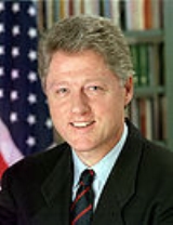
, a state that had voted for the Democratic
incumbent, Bill Clinton
in the previous election, once again voted for him, by double digits over the Republican
challenger, Kansas
Senator
Bob Dole
.
United States presidential election, 1996
The United States presidential election of 1996 was a contest between the Democratic national ticket of President Bill Clinton of Arkansas and Vice President Al Gore of Tennessee and the Republican national ticket of former Senator Bob Dole of Kansas for President and former Housing Secretary Jack...
. Voters chose 54 representatives, or electors to the Electoral College, who voted for President
President of the United States
The President of the United States of America is the head of state and head of government of the United States. The president leads the executive branch of the federal government and is the commander-in-chief of the United States Armed Forces....
and Vice President
Vice President of the United States
The Vice President of the United States is the holder of a public office created by the United States Constitution. The Vice President, together with the President of the United States, is indirectly elected by the people, through the Electoral College, to a four-year term...
.
California
California
California is a state located on the West Coast of the United States. It is by far the most populous U.S. state, and the third-largest by land area...
, a state that had voted for the Democratic
Democratic Party (United States)
The Democratic Party is one of two major contemporary political parties in the United States, along with the Republican Party. The party's socially liberal and progressive platform is largely considered center-left in the U.S. political spectrum. The party has the lengthiest record of continuous...
incumbent, Bill Clinton
Bill Clinton
William Jefferson "Bill" Clinton is an American politician who served as the 42nd President of the United States from 1993 to 2001. Inaugurated at age 46, he was the third-youngest president. He took office at the end of the Cold War, and was the first president of the baby boomer generation...
in the previous election, once again voted for him, by double digits over the Republican
Republican Party (United States)
The Republican Party is one of the two major contemporary political parties in the United States, along with the Democratic Party. Founded by anti-slavery expansion activists in 1854, it is often called the GOP . The party's platform generally reflects American conservatism in the U.S...
challenger, Kansas
Kansas
Kansas is a US state located in the Midwestern United States. It is named after the Kansas River which flows through it, which in turn was named after the Kansa Native American tribe, which inhabited the area. The tribe's name is often said to mean "people of the wind" or "people of the south...
Senator
United States Senate
The United States Senate is the upper house of the bicameral legislature of the United States, and together with the United States House of Representatives comprises the United States Congress. The composition and powers of the Senate are established in Article One of the U.S. Constitution. Each...
Bob Dole
Bob Dole
Robert Joseph "Bob" Dole is an American attorney and politician. Dole represented Kansas in the United States Senate from 1969 to 1996, was Gerald Ford's Vice Presidential running mate in the 1976 presidential election, and was Senate Majority Leader from 1985 to 1987 and in 1995 and 1996...
.
Results
| United States presidential election in California, 1996 | |||||
|---|---|---|---|---|---|
| Party | Candidate | Votes | Percentage | Electoral votes | |
| Democratic Democratic Party (United States) The Democratic Party is one of two major contemporary political parties in the United States, along with the Republican Party. The party's socially liberal and progressive platform is largely considered center-left in the U.S. political spectrum. The party has the lengthiest record of continuous... |
Bill Clinton Bill Clinton William Jefferson "Bill" Clinton is an American politician who served as the 42nd President of the United States from 1993 to 2001. Inaugurated at age 46, he was the third-youngest president. He took office at the end of the Cold War, and was the first president of the baby boomer generation... (incumbent Incumbent The incumbent, in politics, is the existing holder of a political office. This term is usually used in reference to elections, in which races can often be defined as being between an incumbent and non-incumbent. For example, in the 2004 United States presidential election, George W... ) |
5,119,835 | 51.10% | 54 | |
| Republican Republican Party (United States) The Republican Party is one of the two major contemporary political parties in the United States, along with the Democratic Party. Founded by anti-slavery expansion activists in 1854, it is often called the GOP . The party's platform generally reflects American conservatism in the U.S... |
Bob Dole Bob Dole Robert Joseph "Bob" Dole is an American attorney and politician. Dole represented Kansas in the United States Senate from 1969 to 1996, was Gerald Ford's Vice Presidential running mate in the 1976 presidential election, and was Senate Majority Leader from 1985 to 1987 and in 1995 and 1996... |
3,828,380 | 38.21% | 0 | |
| Reform Reform Party of the United States of America The Reform Party of the United States of America is a political party in the United States, founded in 1995 by Ross Perot... |
Ross Perot Ross Perot Henry Ross Perot is a U.S. businessman best known for running for President of the United States in 1992 and 1996. Perot founded Electronic Data Systems in 1962, sold the company to General Motors in 1984, and founded Perot Systems in 1988... |
697,847 | 6.96% | 0 | |
| Green Green Party (United States) The Green Party of the United States is a nationally recognized political party which officially formed in 1991. It is a voluntary association of state green parties. Prior to national formation, many state affiliates had already formed and were recognized by other state parties... |
Ralph Nader Ralph Nader Ralph Nader is an American political activist, as well as an author, lecturer, and attorney. Areas of particular concern to Nader include consumer protection, humanitarianism, environmentalism, and democratic government.... |
237,016 | 2.37% | 0 | |
| Libertarian Libertarian Party (United States) The Libertarian Party is the third largest and fastest growing political party in the United States. The political platform of the Libertarian Party reflects its brand of libertarianism, favoring minimally regulated, laissez-faire markets, strong civil liberties, minimally regulated migration... |
Harry Browne Harry Browne Harry Browne was an American libertarian writer, politician, and free-market investment analyst. He ran for President of the United States as the nominee of the Libertarian Party in 1996 and 2000.... |
73,600 | 0.73% | 0 | |
| Peace and Freedom | Marsha Feinland Marsha Feinland Marsha Feinland was a third-party candidate for President of the United States in the 1996 U.S. presidential election. Her running mate was Kate McClatchy; they were only on the ballot in California and received 25,332 votes... |
25,332 | 0.25% | 0 | |
| American Independent American Independent Party The American Independent Party is a right-wing political party of the United States that was established in 1967 by Bill and Eileen Shearer. In 1968, the American Independent Party nominated George C. Wallace as its presidential candidate and retired Air Force General Curtis E. LeMay as the vice... |
Howard Phillips | 21,202 | 0.21% | 0 | |
| Natural Law | John Hagelin John Hagelin John Samuel Hagelin is an American particle physicist, three-time candidate of the Natural Law Party for President of the United States , and the director of the Transcendental Meditation movement for the US.... |
15,403 | 0.15% | 0 | |
| No party | Charles Collins Charles Collins Charles Collins may refer to:*Charles E. Collins, independent candidate for the president of the United States in 1996 and 2000*Charles Collins , American actor*Charles Collins c.1680–1744, Irish painter... (write-in Write-in candidate A write-in candidate is a candidate in an election whose name does not appear on the ballot, but for whom voters may vote nonetheless by writing in the person's name. Some states and local jurisdictions allow a voter to affix a sticker with a write-in candidate's name on it to the ballot in lieu... ) |
765 | 0.01% | 0 | |
| No party | James Harris James Harris James Harris is the name of:*James Harris, 1st Earl of Malmesbury , English diplomatist*James Harris, 2nd Earl of Malmesbury , British peer*James Harris, 3rd Earl of Malmesbury , British statesman... (write-in) |
77 | 0.00% | 0 | |
| No party | Joel Neuberg (write-in) | 13 | 0.00% | 0 | |
| No party | Willie Carter (write-in) | 12 | 0.00% | 0 | |
| No party | Isabell Masters Isabell Masters Dr. Isabell Masters, Ph.D of Topeka, Kansas, was a five-time perennial third-party candidate for President of the United States.... (write-in) |
2 | 0.00% | 0 | |
| Invalid or blank votes | 242,155 | 2.36% | — | ||
| Totals | 10,261,639 | 100.0% | 54 | ||
| Voter turnout | 65.53% | — | |||
By county
| County | Clinton Bill Clinton William Jefferson "Bill" Clinton is an American politician who served as the 42nd President of the United States from 1993 to 2001. Inaugurated at age 46, he was the third-youngest president. He took office at the end of the Cold War, and was the first president of the baby boomer generation... |
Votes | Dole Bob Dole Robert Joseph "Bob" Dole is an American attorney and politician. Dole represented Kansas in the United States Senate from 1969 to 1996, was Gerald Ford's Vice Presidential running mate in the 1976 presidential election, and was Senate Majority Leader from 1985 to 1987 and in 1995 and 1996... |
Votes | Perot Ross Perot Henry Ross Perot is a U.S. businessman best known for running for President of the United States in 1992 and 1996. Perot founded Electronic Data Systems in 1962, sold the company to General Motors in 1984, and founded Perot Systems in 1988... |
Votes | Nader Ralph Nader Ralph Nader is an American political activist, as well as an author, lecturer, and attorney. Areas of particular concern to Nader include consumer protection, humanitarianism, environmentalism, and democratic government.... |
Votes | Others | Votes |
|---|---|---|---|---|---|---|---|---|---|---|
| San Francisco | 72.24% | 209,777 | 15.66% | 45,479 | 3.33% | 9,659 | 7.39% | 21,471 | 1.38% | 3,999 |
| Alameda Alameda County, California Alameda County is a county in the U.S. state of California. It occupies most of the East Bay region of the San Francisco Bay Area. As of the 2010 census it had a population of 1,510,271, making it the 7th most populous county in the state... |
65.77% | 303,903 | 23.07% | 106,581 | 5.25% | 24,270 | 4.42% | 20,432 | 1.48% | 6,858 |
| San Mateo San Mateo County, California San Mateo County is a county located in the San Francisco Bay Area of the U.S. state of California. It covers most of the San Francisco Peninsula just south of San Francisco, and north of Santa Clara County. San Francisco International Airport is located at the northern end of the county, and... |
60.55% | 152,304 | 29.22% | 73,508 | 5.98% | 15,047 | 2.92% | 7,336 | 1.33% | 3,337 |
| Los Angeles Los Angeles County, California Los Angeles County is a county in the U.S. state of California. As of 2010 U.S. Census, the county had a population of 9,818,605, making it the most populous county in the United States. Los Angeles County alone is more populous than 42 individual U.S. states... |
59.34% | 1,430,629 | 30.96% | 746,544 | 6.54% | 157,752 | 1.91% | 45,977 | 1.25% | 30,112 |
| Marin Marin County, California Marin County is a county located in the North San Francisco Bay Area of the U.S. state of California, across the Golden Gate Bridge from San Francisco. As of 2010, the population was 252,409. The county seat is San Rafael and the largest employer is the county government. Marin County is well... |
58.04% | 67,406 | 28.17% | 32,714 | 5.65% | 6,559 | 6.34% | 7,360 | 1.81% | 2,101 |
| Yolo Yolo County, California Yolo County is a county located in the northern part of the U.S. state of California, bordered by the other counties of Sacramento, Solano, Napa, Lake, Colusa, and Sutter. The city of Woodland is its county seat, though Davis is its largest city.... |
56.88% | 33,033 | 32.38% | 18,807 | 5.42% | 3,150 | 4.09% | 2,377 | 1.23% | 712 |
| Santa Clara Santa Clara County, California Santa Clara County is a county located at the southern end of the San Francisco Bay Area in the U.S. state of California. As of 2010 it had a population of 1,781,642. The county seat is San Jose. The highly urbanized Santa Clara Valley within Santa Clara County is also known as Silicon Valley... |
56.88% | 297,639 | 32.16% | 168,291 | 6.67% | 34,908 | 2.35% | 12,312 | 1.94% | 10,141 |
| Santa Cruz Santa Cruz County, California Santa Cruz County is a county located on the Pacific coast of the U.S. state of California, on the California Central Coast. The county forms the northern coast of the Monterey Bay. . As of the 2010 U.S. Census, its population was 262,382. The county seat is Santa Cruz... |
56.52% | 58,250 | 26.94% | 27,766 | 6.36% | 6,555 | 7.57% | 7,803 | 2.61% | 2,688 |
| Contra Costa Contra Costa County, California Contra Costa County is a primarily suburban county in the San Francisco Bay Area of the U.S. state of California. As of the 2010 census, it had a population of 1,049,025... |
55.73% | 196,512 | 35.15% | 123,954 | 5.79% | 20,416 | 2.08% | 7,334 | 1.24% | 4,386 |
| Sonoma Sonoma County, California Sonoma County, located on the northern coast of the U.S. state of California, is the largest and northernmost of the nine San Francisco Bay Area counties. Its population at the 2010 census was 483,878. Its largest city and county seat is Santa Rosa.... |
55.57% | 100,738 | 29.54% | 53,555 | 7.65% | 13,862 | 5.27% | 9,547 | 1.98% | 3,595 |
| Imperial Imperial County, California Imperial County is a county located in the Imperial Valley, in the far southeast of the U.S. state of California, bordering both Arizona and Mexico. It is part of the El Centro Metropolitan Area, which encompasses all of Imperial County. The population as of 2000 was 142,361. The county seat is the... |
55.27% | 14,591 | 36.76% | 9,705 | 6.73% | 1,778 | 0.58% | 154 | 0.65% | 172 |
| Solano Solano County, California Solano County is a county located in Bay-Delta region of the U.S. state of California, about halfway between San Francisco and Sacramento and is one of the nine San Francisco Bay Area counties. The county's population was reported by the U.S. Census to be 413,344 in 2010... |
55.12% | 64,644 | 34.74% | 40,742 | 7.40% | 8,682 | 1.59% | 1,868 | 1.15% | 1,343 |
| Monterey Monterey County, California Monterey County is a county located on the Pacific coast of the U.S. state of California, its northwestern section forming the southern half of Monterey Bay. The northern half of the bay is in Santa Cruz County. As of 2010, the population was 415,057. The county seat and largest city is Salinas... |
53.15% | 57,700 | 36.66% | 39,794 | 6.67% | 7,240 | 2.20% | 2,391 | 1.32% | 1,433 |
| Napa Napa County, California Napa County is a county located north of the San Francisco Bay Area in the U.S. state of California. It is coterminous with the Napa, California, Metropolitan Statistical Area. As of 2010 the population is 136,484. The county seat is Napa.... |
50.89% | 24,588 | 36.09% | 17,439 | 8.80% | 4,254 | 2.57% | 1,242 | 1.65% | 796 |
| San Benito San Benito County, California San Benito County is a county located in the Coast Range Mountains of the U.S. state of California, south of San Jose. As of 2010 the population was 55,269. The county seat is Hollister, which includes nearly two-thirds of the county's population. El Camino Real passes through the county and... |
50.55% | 7,030 | 38.72% | 5,384 | 7.51% | 1,044 | 1.70% | 236 | 1.52% | 212 |
| Sacramento Sacramento County, California Sacramento County is a county in the U.S. state of California. Its county seat is Sacramento, which is also the state capital. As of 2010 the county had a population of 1,418,788.... |
49.83% | 203,019 | 40.76% | 166,049 | 5.86% | 23,856 | 2.24% | 9,142 | 1.31% | 5,348 |
| Lake Lake County, California Lake County is a county located in the north central portion of the U.S. state of California, north of the San Francisco Bay Area. It takes its name from Clear Lake, the dominant geographic feature in the county and the largest natural lake wholly within California... |
48.90% | 10,432 | 34.96% | 7,458 | 11.90% | 2,539 | 2.73% | 583 | 1.51% | 323 |
| Santa Barbara Santa Barbara County, California Santa Barbara County is a county located in the southern portion of the U.S. state of California, on the Pacific coast. As of 2010 the county had a population of 423,895. The county seat is Santa Barbara and the largest city is Santa Maria.-History:... |
46.87% | 70,650 | 42.40% | 63,915 | 6.27% | 9,457 | 3.17% | 4,774 | 1.29% | 1,949 |
| Merced Merced County, California Merced County , is a county located in the Central Valley of the U.S. state of California, north of Fresno and southeast of San Jose. As of the 2010 census, the population was 255,793, up from 210,554 at the 2000 census. The county seat is Merced... |
46.41% | 21,786 | 44.41% | 20,847 | 7.30% | 3,427 | 0.98% | 462 | 0.89% | 416 |
| San Joaquin San Joaquin County, California San Joaquin County is a county located in Central Valley of the U.S. state of California, just east of the San Francisco Bay Area. As of the 2010 census, the population was 685,306. The county seat is Stockton.-History:... |
46.34% | 67,253 | 44.87% | 65,131 | 6.68% | 9,692 | 1.03% | 1,501 | 1.08% | 1,563 |
| Stanislaus Stanislaus County, California Stanislaus County is a county located in the Central Valley of the U.S. state of California. As the price of housing has increased in the San Francisco Bay Area, many people who work in the southern reaches of the Bay Area have opted for the longer commute and moved to Stanislaus County for the... |
45.93% | 53,738 | 44.79% | 52,403 | 7.14% | 8,360 | 1.00% | 1,172 | 1.14% | 1,334 |
| Mendocino Mendocino County, California Mendocino County is a county located on the north coast of the U.S. state of California, north of the greater San Francisco Bay Area and west of the Central Valley. As of the 2010 census, the population was 87,841, up from 86,265 at the 2000 census... |
45.74% | 14,952 | 29.87% | 9,765 | 11.27% | 3,685 | 11.04% | 3,608 | 2.09% | 682 |
| Fresno Fresno County, California Fresno County is a county located in the Central Valley of the U.S. state of California, south of Stockton and north of Bakersfield. As of the 2010 census, it is the tenth most populous county in California with a population of 930,450, and the sixth largest in size with an area of . The county... |
45.32% | 94,448 | 47.42% | 98,813 | 5.26% | 10,962 | 1.21% | 2,523 | 0.79% | 1,647 |
| San Bernardino San Bernardino County, California San Bernardino County is a county in the U.S. state of California. As of the 2010 census, the population was 2,035,210, up from 1,709,434 as of the 2000 census... |
44.36% | 183,372 | 43.58% | 180,135 | 9.51% | 39,330 | 1.25% | 5,150 | 1.30% | 5,368 |
| Humboldt Humboldt County, California Humboldt County is a county in the U.S. state of California, located on the far North Coast 200 miles north of San Francisco. According to 2010 Census Data, the county’s population was 134,623... |
44.17% | 24,628 | 35.52% | 19,803 | 10.42% | 5,811 | 8.34% | 4,651 | 1.55% | 864 |
| San Diego San Diego County, California San Diego County is a large county located in the southwestern corner of the US state of California. Hence, San Diego County is also located in the southwestern corner of the 48 contiguous United States. Its county seat and largest city is San Diego. Its population was about 2,813,835 in the 2000... |
44.11% | 389,964 | 45.57% | 402,876 | 7.13% | 63,037 | 1.79% | 15,858 | 1.40% | 12,416 |
| Ventura Ventura County, California Ventura County is a county in the southern part of the U.S. state of California. It is located on California's Pacific coast. It is often referred to as the Gold Coast, and has a reputation of being one of the safest populated places and one of the most affluent places in the country... |
44.10% | 110,772 | 43.47% | 109,202 | 9.18% | 23,054 | 1.88% | 4,732 | 1.37% | 3,434 |
| Kings Kings County, California Kings County is a county located in the Central Valley of the U.S. state of California. It is located in a rich agricultural region. Kings County is also home to NAS Lemoore, which is the U.S. Navy's newest and largest master jet air station. The county seat is Hanford... |
43.59% | 11,254 | 47.91% | 12,368 | 6.76% | 1,745 | 0.79% | 205 | 0.94% | 243 |
| Riverside Riverside County, California Riverside County is a county in the U.S. state of California. One of 58 California counties, it covers in the southern part of the state, and stretches from Orange County to the Colorado River, which forms the state border with Arizona. The county derives its name from the city of Riverside,... |
43.05% | 168,579 | 45.61% | 178,611 | 9.06% | 35,481 | 1.23% | 4,814 | 1.05% | 4,128 |
| Alpine Alpine County, California Alpine County is the smallest county, by population, in the U.S. state of California. As of 2010, it had a population of 1,175, all rural. There are no incorporated cities in the county. The county seat is Markleeville... |
42.02% | 258 | 43.00% | 264 | 10.26% | 63 | 3.09% | 19 | 1.63% | 10 |
| Del Norte Del Norte County, California Del Norte County is a county located at the far northwest corner of the U.S. state of California on the Pacific adjacent to the Oregon border. As of the 2010 census, it had a population of 28,610. The county seat is Crescent City, the county's only incorporated city. Del Norte is the abbreviated... |
41.08% | 3,652 | 41.29% | 3,670 | 13.78% | 1,225 | 2.24% | 199 | 1.61% | 143 |
| Tuolumne Tuolumne County, California Tuolumne County is a county in the Sierra Nevada of the U.S. state of California. The northern half of Yosemite National Park is located in the eastern part of the county. As of the 2010 census, the population was 55,365, up from 54,501 at the 2000 census... |
40.73% | 8,950 | 47.27% | 10,386 | 8.76% | 1,925 | 1.94% | 427 | 1.29% | 284 |
| Amador Amador County, California Amador County is a county located in the Sierra Nevada of the U.S. state of California. As of the 2010 census, the population was 38,091. The county seat is Jackson.Amador County bills itself as "The Heart of the Mother Lode" and lies within the Gold Country... |
40.60% | 5,868 | 47.54% | 6,870 | 8.77% | 1,267 | 1.83% | 264 | 1.27% | 183 |
| San Luis Obispo San Luis Obispo County, California San Luis Obispo County is a county located along the Pacific Ocean in the Central Coast of the U.S. state of California, between Los Angeles and the San Francisco Bay Area. As of the 2010 census its population was 269,637, up from 246,681 at the 2000 census... |
40.19% | 40,395 | 46.50% | 46,733 | 8.16% | 8,204 | 3.83% | 3,854 | 1.31% | 1,314 |
| Calaveras Calaveras County, California Calaveras County is a county located in the Gold Country of the U.S. state of California. Calaveras is the Spanish word for skulls; the county was reportedly named for the remains of Native Americans discovered by the Spanish explorer Captain Gabriel Moraga. As of the 2010 census, the county had a... |
6646 | 38.63% | 48.12% | 8,279 | 9.37% | 1,612 | 1.96% | 338 | 1.92% | 331 |
| Mono Mono County, California Mono County is a county located in the east central portion of the U.S. state of California, to the east of the Sierra Nevada between Yosemite National Park and Nevada. As of the 2010 census, the population was 14,202, up from 12,853 at the 2000 census... |
38.62% | 1,580 | 46.00% | 1,882 | 10.93% | 447 | 2.35% | 96 | 2.10% | 86 |
| Butte Butte County, California Butte County is a county located in the Central Valley of the US state of California, north of the state capital of Sacramento. As of the 2010 census, it had a population of 220,000. The county seat is Oroville. Butte County is the "Land of Natural Wealth and Beauty."Butte County is watered by the... |
38.53% | 30,651 | 48.98% | 38,961 | 8.04% | 6,393 | 3.03% | 2,409 | 1.43% | 1,136 |
| Siskiyou Siskiyou County, California Siskiyou County is a county located in the far northernmost part of the U.S. state of California, in the Shasta Cascade region on the Oregon border. Yreka is the county seat. Because of its substantial natural beauty, outdoor recreation opportunities, and Gold Rush era history, it is an important... |
38.39% | 7,022 | 47.30% | 8,653 | 10.27% | 1,879 | 2.03% | 372 | 2.01% | 367 |
| Tulare Tulare County, California Tulare County is a county located in the Central Valley of the U.S. state of California, south of Fresno. Sequoia National Park is located in the county, as are part of Kings Canyon National Park, in its northeast corner , and part of Mount Whitney, on its eastern border... |
38.06% | 32,669 | 53.90% | 46,272 | 5.95% | 5,106 | 0.86% | 737 | 1.24% | 1,062 |
| Orange Orange County, California Orange County is a county in the U.S. state of California. Its county seat is Santa Ana. As of the 2010 census, its population was 3,010,232, up from 2,846,293 at the 2000 census, making it the third most populous county in California, behind Los Angeles County and San Diego County... |
37.88% | 327,485 | 51.67% | 446,717 | 7.66% | 66,195 | 1.37% | 11,842 | 1.43% | 12,337 |
| Yuba Yuba County, California Yuba County is a county located in the U.S. state of California's Central Valley, north of Sacramento, along the Feather River. As of the 2010 census, its population was 72,155. The county seat is Marysville. Yuba County is part of the Greater Sacramento area.-History:Yuba County was one of the... |
37.42% | 5,789 | 51.53% | 7,971 | 8.46% | 1,308 | 1.30% | 201 | 1.30% | 201 |
| Trinity Trinity County, California Trinity County is a large, rugged and mountainous, heavily forested county located in the northwestern portion of the U.S. state of California, along the Trinity River and within the Salmon/Klamath Mountains. It covers an area of over two million acres , and as of the 2010 census its population... |
37.38% | 2,203 | 42.93% | 2,530 | 14.53% | 856 | 2.70% | 159 | 2.46% | 145 |
| Placer Placer County, California Placer County is a county located in both the Sacramento Valley and Sierra Nevada regions of the U.S. state of California, in what is known as the Gold Country. It stretches from the suburbs of Sacramento to Lake Tahoe and the Nevada border. Because of the expansion of the Greater Sacramento,... |
37.05% | 34,981 | 52.75% | 49,808 | 6.93% | 6,542 | 1.99% | 1,875 | 1.29% | 1,221 |
| Mariposa Mariposa County, California Mariposa County is a county in the U.S. state of California, located in the western foothills of the Sierra Nevada mountains. It lies north of Fresno, east of Merced, and southeast of Stockton. As of the 2010 census, the population was 18,251 up from 17,130 at the 2000 census... |
36.73% | 2,920 | 50.02% | 3,976 | 9.17% | 729 | 2.42% | 192 | 1.66% | 132 |
| Madera Madera County, California Madera County is a county of the U.S. state of California, located in the Central Valley and the Sierra Nevada north of Fresno County. It comprises the Madera-Chowchilla, CA Metropolitan Statistical Area. As of the 2010 census the population was 150,865... |
36.70% | 11,254 | 53.85% | 16,510 | 7.15% | 2,192 | 1.23% | 376 | 1.08% | 330 |
| Colusa Colusa County, California Colusa County is a county located in the Central Valley of the U.S. state of California, northwest of state capital Sacramento. As of the 2010 census, its population was 21,419. The county seat is Colusa.-History:... |
36.60% | 2,054 | 54.29% | 3,047 | 7.20% | 404 | 0.75% | 42 | 1.16% | 65 |
| Kern Kern County, California Spreading across the southern end of the California Central Valley, Kern County is the fifth-largest county by population in California. Its economy is heavily linked to agriculture and to petroleum extraction, and there is a strong aviation and space presence. Politically, it has generally... |
36.56% | 62,658 | 53.77% | 92,151 | 7.85% | 13,452 | 0.75% | 1,289 | 1.07% | 1,841 |
| El Dorado El Dorado County, California El Dorado County is a county located in the historic Gold Country in the Sierra Nevada Mountains and foothills of the U.S. state of California. The 2010 population was 181,058. The El Dorado county seat is in Placerville.... |
36.33% | 22,957 | 51.84% | 32,759 | 8.03% | 5,077 | 2.28% | 1,439 | 1.53% | 964 |
| Plumas Plumas County, California Plumas County is a county located in the Sierra Nevada of the U.S. state of California. The county gets its name from the Spanish words for the Feather River , which flows through the county. As of the 2010 census, the population 20,007, down from 20,824 at the 2000 census... |
36.31% | 3,540 | 50.31% | 4,905 | 9.43% | 919 | 2.19% | 214 | 1.76% | 172 |
| Tehama Tehama County, California Tehama County is a county located in the northern part of the U.S. state of California. It is bisected by the Sacramento River. As of 2010 its population was 63,463, up from 56,039 as of 2000. The county seat is Red Bluff.-History:... |
35.66% | 7,290 | 50.34% | 10,292 | 11.37% | 2,325 | 1.20% | 245 | 1.42% | 291 |
| Nevada Nevada County, California Nevada County is a county located in the Sierra Nevada of California, in the Mother Lode country. As of 2010 its population was 98,764. The county seat is Nevada City.-History:Nevada County was created in 1851 from parts of Yuba County.... |
35.56% | 15,369 | 50.40% | 21,784 | 7.70% | 3,330 | 4.85% | 2,097 | 1.48% | 639 |
| Sutter Sutter County, California Sutter County is a county located along the Sacramento River in the Central Valley of the U.S. state of California, north of state capital Sacramento. Sutter County is part of the Greater Sacramento CSA.... |
34.37% | 8,504 | 57.64% | 14,264 | 6.20% | 1,533 | 0.84% | 208 | 0.95% | 236 |
| Inyo Inyo County, California -National protected areas:* Death Valley National Park * Inyo National Forest * Manzanar National Historic Site-Major highways:* U.S. Route 6* U.S. Route 395* State Route 127* State Route 136* State Route 168* State Route 178... |
34.36% | 2,601 | 51.84% | 3,924 | 10.71% | 811 | 1.68% | 127 | 1.40% | 106 |
| Lassen Lassen County, California Lassen County is a county located in the northeastern portion of the U.S. state of California. As of the 2010 census, the population was 34,895, up from 33,828 at the 2000 census... |
33.60% | 3,318 | 52.60% | 5,194 | 10.94% | 1,080 | 1.33% | 131 | 1.54% | 152 |
| Sierra Sierra County, California Sierra County is a county located in the Sierra Nevada of the U.S. state of California, northeast of Sacramento on the border with Nevada. As of the 2010 census the population was 3,240, down from 3,555 at the 2000 census. The county seat is Downieville.... |
33.57% | 573 | 51.38% | 877 | 9.96% | 170 | 2.34% | 40 | 2.75% | 47 |
| Shasta Shasta County, California Shasta County is a county located in the northern portion of the U.S. state of California. The county occupies the northern reaches of the Sacramento Valley, with portions extending into the southern reaches of the Cascade Range. As of the 2010 census, the population was 177,223, up from 163,256... |
33.11% | 20,848 | 55.17% | 34,736 | 9.33% | 5,875 | 1.07% | 675 | 1.31% | 827 |
| Glenn Glenn County, California Glenn County is in the California Central Valley. As of 2010, it had a population of 28,122. The county seat is the city of Willows.-History:Glenn County was formed in 1891 from parts of Colusa County. It was named for Dr. Hugh J... |
32.04% | 2,841 | 56.86% | 5,041 | 8.89% | 788 | 0.96% | 85 | 1.25% | 111 |
| Modoc Modoc County, California Modoc County is a county located in the far northeast corner of the U.S. state of California, bounded by the state of Oregon to the north and the state of Nevada to the east. As of the 2010 census, its population was 9,686, up from 9,449 at the 2000 census. The current county seat is Alturas, the... |
31.79% | 1,368 | 53.10% | 2,285 | 12.27% | 528 | 1.14% | 49 | 1.70% | 73 |