

Transport in Ireland
Encyclopedia
Most of the transport system in Ireland
is in public hands, either side of the Irish border. The Irish road network
has evolved separately in the two jurisdictions Ireland
is divided up into, while the Irish rail network
was mostly created prior to the partition of Ireland
.
In the Republic of Ireland
, the Minister for Transport
, acting through the Department of Transport
, is responsible for the State's road
network, rail network
, public transport
, airport
s and several other areas. Although some sections of road have been built using private or public-private funds
, and are operated as toll road
s, they are owned by the Government of Ireland. The rail network is also state-owned
and operated, while the government currently still owns the main airports. Public transport is mainly in the hands of a statutory corporation
, Córas Iompair Éireann
(CIÉ), and its subsidiaries, Bus Átha Cliath (Dublin Bus
), Bus Éireann
(Irish Bus), and Iarnród Éireann
(Irish Rail).
On November 1, 2005, the Dublin government published the Transport 21
plan which includes €18bn for improved roads and €16bn for improved rail, including the Western Railway Corridor
and the Dublin Metro
.
In Northern Ireland
, the road network and railways are in state ownership. The Department for Regional Development
is responsible for these and other areas (such as water services). Two of the three main airports in Northern Ireland are privately operated and owned. The exception is City of Derry Airport
, which is owned and funded by Derry City Council
. A statutory corporation, the Northern Ireland Transport Holding Company
(which trades as Translink
) operates public transport services through its three subsidiaries - NI Railways Company Limited, Ulsterbus
Limited, and Citybus Limited
(now branded as Metro).
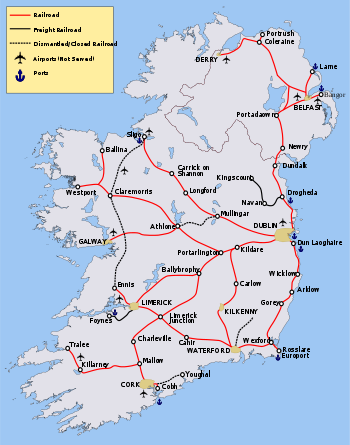
Ireland's railways are in State ownership, with Iarnród Éireann
(Irish Rail) operating services in the Republic and NI Railways operating services in Northern Ireland. The two companies co-operate in providing the joint Enterprise service between Dublin and Belfast
. InterCity
services are provided between Dublin and the major towns and cities of the Republic, and between Belfast and Derry
. Suburban railway networks operate in Dublin, Dublin Suburban Rail
, and Belfast, Belfast Suburban Rail
, with limited local services being offered in, or planned for, Cork
, Limerick
, and Galway
.
Many lines in the west were decommissioned in the 1930s under Éamon de Valera
, with a further large cull in services by both CIÉ and the Ulster Transport Authority
(UTA) during the 1960s, leaving few working lines in the northern third of the island. There is a campaign to bring some closed lines back into service, in particular the Limerick-Sligo
line (the Western Railway Corridor
), to facilitate economic regeneration in the west, which has lagged behind the rest of the country. There is also a move to restore service on the Dublin to Navan
line, and smaller campaigns to re-establish the rail links between Sligo and Enniskillen
/Omagh
/Derry and Mullingar and Athlone/Galway
Since 1984 an electrically operated train service has run between Bray
and Howth
, called the Dublin Area Rapid Transit
. In 2004 a light rail
system, Luas, was opened in Dublin. As of September 2008, legal permission has been sought to build a metro
system is also in the planning stage. The construction of the Luas system caused much disruption in Dublin; in retrospect many believe an underground
would have been a better option. One of the current options being discussed is to upgrade the Luas
to a metro system when the metro is being installed.
Total - 117318 km (72,898.2 mi)
Ireland's roads link Dublin with all the major cities (Cork, Limerick, Galway, Waterford
, Belfast and Derry). Driving is on the left.
State-owned Bus Éireann
(Irish Bus) provides most bus services in the Republic of Ireland, outside Dublin, including an express coach network connecting most cities in Ireland, along with local bus services in the provincial cities. There are also a number of private operators, the biggest of which include Aircoach
, a subsidiary of FirstGroup which provides services to Dublin Airport
from Dublin city centre, South Dublin City, Greystones, Bray, and Cork amongst other operators such as Irish Citylink and GoBus.ie which compete on the Dublin-Galway route. Matthews Coaches run a direct service from Bettystown
, Laytown
and Julianstown
to Dublin.
Some private rural operators exist, such as Halpenny's in Blackrock
, County Louth
, who were the first private bus operator to run a public service in Ireland, Bus Feda (Feda O'Donnell Coaches), who operate twice daily routes from Ranafast
, County Donegal
to Galway and back, as well as Lough Swilly Bus Company
.
Bus Átha Cliath (Dublin Bus
), a sister company of Bus Éireann
, provides most of the bus services in Dublin, with some other operators providing a number of routes.
In Northern Ireland Ulsterbus
provides the bus network, with its sister company Metro
providing services in Belfast. Both are part of state-owned Translink
.
Tiger Coaches operates a very late night bus service on Friday and Saturday nights between Belfast and Lisburn.
Most cross-border services (e.g. Dublin city centre to Belfast) are run jointly between Bus Éireann and Ulsterbus, with some services run across the border exclusively by one of the two companies (e.g. Derry–Sligo run by Bus Éireann).
transmission network 1795 km (1,115.4 mi) (2003). There is a much more extensive distribution network.
, Belfast (Port of Belfast
), Cork (Cork Harbour
), Derry (Londonderry Port
), Drogheda
, Dublin (Dublin Port
), Dundalk
, Dún Laoghaire
, Foynes
, Galway, Larne
, Limerick, New Ross
, Rosslare Europort
, Sligo, Waterford (Port of Waterford
) and Wicklow
.
Ports in the Republic handle 3,600,000 travelers crossing the Irish Sea
each year, amounting to 92% of all sea travel. This has been steadily dropping for a number of years (20% since 1999), probably as a result of low cost airlines
.
Ferry connections between Britain
and Ireland via the Irish Sea include the routes from Swansea
to Cork, Fishguard
and Pembroke
to Rosslare, Holyhead
to Dún Laoghaire, Stranraer
to Belfast and Larne, and Cairnryan
to Larne. There is also a connection between Liverpool
and Belfast via the Isle of Man
. The world's largest car ferry, Ulysses
, is operated by Irish Ferries
on the Dublin–Holyhead route.
In addition, Rosslare and Cork run ferries to France
.
The vast majority of heavy goods trade is done by sea. Northern Irish ports handle 10 megatonnes (Mt) of goods trade with Britain annually, while ports in the south handle 7.6 Mt, representing 50% and 40% respectively of total trade by weight.
Several potential Irish Sea tunnel projects have been proposed, most recently the "Tusker Tunnel
" between the ports of Rosslare and Fishguard proposed by the Institution of Engineers of Ireland
in 2004. A different proposed route is between Dublin and Holyhead, proposed in 1997 by a leading British engineering firm, Symonds, for a rail tunnel from Dublin to Holyhead. Either tunnel, at 80 km (49.7 mi), would be by far the longest in the world, and would cost an estimated €20bn.
, Cork Airport, Shannon Airport
and Ireland West Airport Knock
.
There are many regional airports including, Galway Airport
, Donegal Airport
, Sligo Airport
, Kerry Airport
and Waterford Airport
. Services to the Aran Islands
are operated from Aerfort na Minna (Connemara Regional Airport).
Ireland's National Airline, Aer Lingus
provides air services from Belfast International, Cork, Dublin and Shannon to Europe
, North Africa
and North America
. Cork, Dublin and Shannon airports are run by the State body, the DAA
(Dublin Airport Authority). Other Irish airlines are Ryanair
, one of the largest in the world, Aer Arann
, CityJet
, Air Contractors
and the newly launched Aer Lingus subsidiary Aer Lingus Regional
. There are a number of other operators specialising in general aviation.
. The others are George Best Belfast City Airport
and City of Derry Airport
.
† Latest available figures are for 2007.
†† Latest available figures are for 2006.
Public transport in Ireland
Public transport in Ireland exists in many of the island's urban areas, and takes a number of forms. Bus transport is the main form of public transport common in all cities. The cities, Dublin, Belfast, Cork, Limerick and Galway all have their own suburban rail networks...
is in public hands, either side of the Irish border. The Irish road network
Roads in Ireland
The island of Ireland, comprising Northern Ireland and the Republic of Ireland, has an extensive network of tens of thousands of kilometres of public roads, usually surfaced. These roads have been developed and modernised over centuries, from trackways suitable only for walkers and horses, to...
has evolved separately in the two jurisdictions Ireland
Ireland
Ireland is an island to the northwest of continental Europe. It is the third-largest island in Europe and the twentieth-largest island on Earth...
is divided up into, while the Irish rail network
Rail transport in Ireland
Rail services in Ireland are provided by Iarnród Éireann in the Republic of Ireland and by Northern Ireland Railways in Northern Ireland.Most routes in the Republic radiate from Dublin...
was mostly created prior to the partition of Ireland
Partition of Ireland
The partition of Ireland was the division of the island of Ireland into two distinct territories, now Northern Ireland and the Republic of Ireland . Partition occurred when the British Parliament passed the Government of Ireland Act 1920...
.
In the Republic of Ireland
Republic of Ireland
Ireland , described as the Republic of Ireland , is a sovereign state in Europe occupying approximately five-sixths of the island of the same name. Its capital is Dublin. Ireland, which had a population of 4.58 million in 2011, is a constitutional republic governed as a parliamentary democracy,...
, the Minister for Transport
Minister for Transport (Ireland)
The Minister for Transport, Tourism and Sport is the senior minister at the Department of Transport, Tourism and Sport in the Government of Ireland.The current Minister for Transport, Tourism and Sport is Leo Varadkar, TD...
, acting through the Department of Transport
Department of Transport (Ireland)
The Department of Transport, Tourism and Sport is a department of the Government of Ireland that is responsible for transport policy and overseeing transport services and infrastructure. The Department is led by the Minister for Transport, Tourism and Sport who is assisted by two Ministers of State...
, is responsible for the State's road
Road
A road is a thoroughfare, route, or way on land between two places, which typically has been paved or otherwise improved to allow travel by some conveyance, including a horse, cart, or motor vehicle. Roads consist of one, or sometimes two, roadways each with one or more lanes and also any...
network, rail network
Rail transport
Rail transport is a means of conveyance of passengers and goods by way of wheeled vehicles running on rail tracks. In contrast to road transport, where vehicles merely run on a prepared surface, rail vehicles are also directionally guided by the tracks they run on...
, public transport
Public transport
Public transport is a shared passenger transportation service which is available for use by the general public, as distinct from modes such as taxicab, car pooling or hired buses which are not shared by strangers without private arrangement.Public transport modes include buses, trolleybuses, trams...
, airport
Airport
An airport is a location where aircraft such as fixed-wing aircraft, helicopters, and blimps take off and land. Aircraft may be stored or maintained at an airport...
s and several other areas. Although some sections of road have been built using private or public-private funds
Public-private partnership
Public–private partnership describes a government service or private business venture which is funded and operated through a partnership of government and one or more private sector companies...
, and are operated as toll road
Toll road
A toll road is a privately or publicly built road for which a driver pays a toll for use. Structures for which tolls are charged include toll bridges and toll tunnels. Non-toll roads are financed using other sources of revenue, most typically fuel tax or general tax funds...
s, they are owned by the Government of Ireland. The rail network is also state-owned
Government-owned corporation
A government-owned corporation, state-owned company, state-owned entity, state enterprise, publicly owned corporation, government business enterprise, or parastatal is a legal entity created by a government to undertake commercial activities on behalf of an owner government...
and operated, while the government currently still owns the main airports. Public transport is mainly in the hands of a statutory corporation
Statutory Corporation
A statutory corporation or public body is a corporation created by statute. While artificial legal personality is almost always the result of statutory intervention, a statutory corporation does not include corporations owned by shareholders whose legal personality derives from being registered...
, Córas Iompair Éireann
Córas Iompair Éireann
Córas Iompair Éireann , or CIÉ, is a statutory corporation of the Irish state, answerable to the Irish Government and responsible for most public transport in the Republic of Ireland and, jointly with its Northern Ireland counterpart, the Northern Ireland Transport Holding Company, between the...
(CIÉ), and its subsidiaries, Bus Átha Cliath (Dublin Bus
Dublin Bus
Dublin Bus is a public transport operator in Ireland. It operates an extensive bus network of 172 radial, cross-city and peripheral routes and 18 night routes in the city of Dublin and the Greater Dublin Area. The company, established in 1987, is a subsidiary of Córas Iompair Éireann which is...
), Bus Éireann
Bus Éireann
Bus Éireann provides bus services in Ireland with the exception of those operated entirely within the Dublin Region, which are provided by Dublin Bus. Bus Éireann, established as a separate company in 1987, is a subsidiary of Córas Iompair Éireann. The logo of Bus Éireann incorporates a red Irish...
(Irish Bus), and Iarnród Éireann
Iarnród Éireann
Iarnród Éireann is the national railway system operator of Ireland. Established on 2 February 1987, it is a subsidiary of Córas Iompair Éireann . It operates all internal intercity, commuter and freight railway services in the Republic of Ireland, and, jointly with Northern Ireland Railways, the...
(Irish Rail).
On November 1, 2005, the Dublin government published the Transport 21
Transport 21
Transport 21 is an Irish infrastructure plan, announced in November 2005. It aims to greatly expand Ireland's transport network. A cost estimate of €34 billion was attached to the plan at the time....
plan which includes €18bn for improved roads and €16bn for improved rail, including the Western Railway Corridor
Western Railway Corridor
The Western Railway Corridor , or Conair Iarnróid an Iarthair , in Ireland is a recent term for a mostly disused railway line running through the West of Ireland...
and the Dublin Metro
Dublin Metro
The Dublin Metro is a proposed metro system for the city of Dublin. The first two lines were set out in the Irish Government's 2005 Transport 21 transport plan: they are known as Metro North and Metro West...
.
In Northern Ireland
Northern Ireland
Northern Ireland is one of the four countries of the United Kingdom. Situated in the north-east of the island of Ireland, it shares a border with the Republic of Ireland to the south and west...
, the road network and railways are in state ownership. The Department for Regional Development
Department for Regional Development
The Department for Regional Development is a devolved Northern Ireland government department in the Northern Ireland Executive...
is responsible for these and other areas (such as water services). Two of the three main airports in Northern Ireland are privately operated and owned. The exception is City of Derry Airport
City of Derry Airport
City of Derry Airport is an airport located northeast of Derry, Northern Ireland. It is located on the south bank of Lough Foyle, a short distance from the village of Eglinton and from the city centre...
, which is owned and funded by Derry City Council
Derry City Council
Derry City Council is a district council in County Londonderry in Northern Ireland. The Council is is responsible for the city of Derry and the immediate environ, providing services to an estimated population of , making it the third largest district council in Northern Ireland by population.The...
. A statutory corporation, the Northern Ireland Transport Holding Company
Northern Ireland Transport Holding Company
The Northern Ireland Transport Holding Company is a government-owned body which was established in 1967 to take over the railway and bus services of the Ulster Transport Authority , namely Northern Ireland Railways and Ulsterbus...
(which trades as Translink
Translink (Northern Ireland)
Translink is the brand name of the Northern Ireland Transport Holding Company , a public corporation in Northern Ireland which provides the public transport in the region. NI Railways, Ulsterbus and Metro are all part of Translink....
) operates public transport services through its three subsidiaries - NI Railways Company Limited, Ulsterbus
Ulsterbus
Ulsterbus is a public transport operator in Northern Ireland and operates bus services outside Belfast. It is part of Translink , which also includes Northern Ireland Railways, Metro Belfast and Flexibus.-Services:Ulsterbus is responsible for most of the province-wide bus...
Limited, and Citybus Limited
Metro (Belfast)
Metro is the trading name for bus company Citybus in Belfast, Northern Ireland. It is a subsidiary of the Northern Ireland Transport Holding Company, within the common management structure of Translink, along with Ulsterbus and Northern Ireland Railways....
(now branded as Metro).
Railways
Total- broad gaugeIrish gaugeIrish gauge railways use a track gauge of . It is used in* Ireland * Australia where it is also known as Victorian Broad Gauge* Brazil where it is also known as Bitola larga no Brasil....
- 1947 km (1,209.8 mi) (1998); 38 km (23.6 mi) electrified; 485 km (301.4 mi) double track; some addititions and removals since 1997
- standard gaugeStandard gaugeThe standard gauge is a widely-used track gauge . Approximately 60% of the world's existing railway lines are built to this gauge...
- 28 km (17.4 mi) (2004) (LuasLuasLuas , also promoted in the development stage as the Dublin Light Rail System, is a tram or light rail system serving Dublin, the first such system in the decades since the closure of the last of the Dublin tramways. In 2007, the system carried 28.4 million passengers, a growth of 10% since...
tramway); 28 km (17.4 mi) electrified; 28 km (17.4 mi) double track; additional track under construction
- narrow gauge
- 1365 km (848.2 mi) (2006) (industrial railway operated by Bord na MónaBord na MónaBord na Móna , abbreviated BNM, is a semi-state company in Ireland, created in 1946 by the Turf Development Act 1946. The company is responsible for the mechanised harvesting of peat, primarily in the Midlands of Ireland...
)
Ireland's railways are in State ownership, with Iarnród Éireann
Iarnród Éireann
Iarnród Éireann is the national railway system operator of Ireland. Established on 2 February 1987, it is a subsidiary of Córas Iompair Éireann . It operates all internal intercity, commuter and freight railway services in the Republic of Ireland, and, jointly with Northern Ireland Railways, the...
(Irish Rail) operating services in the Republic and NI Railways operating services in Northern Ireland. The two companies co-operate in providing the joint Enterprise service between Dublin and Belfast
Belfast
Belfast is the capital of and largest city in Northern Ireland. By population, it is the 14th biggest city in the United Kingdom and second biggest on the island of Ireland . It is the seat of the devolved government and legislative Northern Ireland Assembly...
. InterCity
InterCity
InterCity is the classification applied to certain long-distance passenger train services in Europe...
services are provided between Dublin and the major towns and cities of the Republic, and between Belfast and Derry
Derry
Derry or Londonderry is the second-biggest city in Northern Ireland and the fourth-biggest city on the island of Ireland. The name Derry is an anglicisation of the Irish name Doire or Doire Cholmcille meaning "oak-wood of Colmcille"...
. Suburban railway networks operate in Dublin, Dublin Suburban Rail
Dublin Suburban Rail
The Dublin Suburban Rail network, , is a railway network that serves the city of Dublin, Ireland, most of the Greater Dublin Area and outlying towns...
, and Belfast, Belfast Suburban Rail
Belfast Suburban Rail
The Belfast Suburban Rail commuter network serves the metropolitan area of Greater Belfast and some of its commuter towns with three lines. The network is owned by Translink and operated by Northern Ireland Railways ....
, with limited local services being offered in, or planned for, Cork
Cork (city)
Cork is the second largest city in the Republic of Ireland and the island of Ireland's third most populous city. It is the principal city and administrative centre of County Cork and the largest city in the province of Munster. Cork has a population of 119,418, while the addition of the suburban...
, Limerick
Limerick
Limerick is the third largest city in the Republic of Ireland, and the principal city of County Limerick and Ireland's Mid-West Region. It is the fifth most populous city in all of Ireland. When taking the extra-municipal suburbs into account, Limerick is the third largest conurbation in the...
, and Galway
Galway
Galway or City of Galway is a city in County Galway, Republic of Ireland. It is the sixth largest and the fastest-growing city in Ireland. It is also the third largest city within the Republic and the only city in the Province of Connacht. Located on the west coast of Ireland, it sits on the...
.
Many lines in the west were decommissioned in the 1930s under Éamon de Valera
Éamon de Valera
Éamon de Valera was one of the dominant political figures in twentieth century Ireland, serving as head of government of the Irish Free State and head of government and head of state of Ireland...
, with a further large cull in services by both CIÉ and the Ulster Transport Authority
Ulster Transport Authority
The Ulster Transport Authority ran rail and bus transport in Northern Ireland from 1948 until 1966.-Formation and consolidation:The UTA was formed by the Transport Act 1948, which merged the Northern Ireland Road Transport Board and the Belfast and County Down Railway...
(UTA) during the 1960s, leaving few working lines in the northern third of the island. There is a campaign to bring some closed lines back into service, in particular the Limerick-Sligo
Sligo
Sligo is the county town of County Sligo in Ireland. The town is a borough and has a charter and a town mayor. It is sometimes referred to as a city, and sometimes as a town, and is the second largest urban area in Connacht...
line (the Western Railway Corridor
Western Railway Corridor
The Western Railway Corridor , or Conair Iarnróid an Iarthair , in Ireland is a recent term for a mostly disused railway line running through the West of Ireland...
), to facilitate economic regeneration in the west, which has lagged behind the rest of the country. There is also a move to restore service on the Dublin to Navan
Navan
-People:Navan was the childhood home of Pierce Brosnan, who appeared in the television series Remington Steele and was the fifth film actor to play James Bond. TV personality Hector Ó hEochagáin, and comedians Dylan Moran and Tommy Tiernan also hail from Navan....
line, and smaller campaigns to re-establish the rail links between Sligo and Enniskillen
Enniskillen
Enniskillen is a town in County Fermanagh, Northern Ireland. It is located almost exactly in the centre of the county between the Upper and Lower sections of Lough Erne. It had a population of 13,599 in the 2001 Census...
/Omagh
Omagh
Omagh is the county town of County Tyrone, Northern Ireland. It is situated where the rivers Drumragh and Camowen meet to form the Strule. The town, which is the largest in the county, had a population of 19,910 at the 2001 Census. Omagh also contains the headquarters of Omagh District Council and...
/Derry and Mullingar and Athlone/Galway
Since 1984 an electrically operated train service has run between Bray
Bray
Bray is a town in north County Wicklow, Ireland. It is a busy urban centre and seaside resort, with a population of 31,901 making it the fourth largest in Ireland as of the 2006 census...
and Howth
Howth
Howth is an area in Fingal County near Dublin city in Ireland. Originally just a small fishing village, Howth with its surrounding rural district is now a busy suburb of Dublin, with a mix of dense residential development and wild hillside, all on the peninsula of Howth Head. The only...
, called the Dublin Area Rapid Transit
Dublin Area Rapid Transit
The Dublin Area Rapid Transit is part of the suburban railway network in Ireland, running mainly along the coastline of Dublin Bay on the Trans-Dublin route, from Greystones in County Wicklow, through Dublin to Howth and Malahide in County Dublin.Trains are powered via a 1500V DC overhead catenary...
. In 2004 a light rail
Light rail
Light rail or light rail transit is a form of urban rail public transportation that generally has a lower capacity and lower speed than heavy rail and metro systems, but higher capacity and higher speed than traditional street-running tram systems...
system, Luas, was opened in Dublin. As of September 2008, legal permission has been sought to build a metro
Rapid transit
A rapid transit, underground, subway, elevated railway, metro or metropolitan railway system is an electric passenger railway in an urban area with a high capacity and frequency, and grade separation from other traffic. Rapid transit systems are typically located either in underground tunnels or on...
system is also in the planning stage. The construction of the Luas system caused much disruption in Dublin; in retrospect many believe an underground
Dublin Metro
The Dublin Metro is a proposed metro system for the city of Dublin. The first two lines were set out in the Irish Government's 2005 Transport 21 transport plan: they are known as Metro North and Metro West...
would have been a better option. One of the current options being discussed is to upgrade the Luas
Luas
Luas , also promoted in the development stage as the Dublin Light Rail System, is a tram or light rail system serving Dublin, the first such system in the decades since the closure of the last of the Dublin tramways. In 2007, the system carried 28.4 million passengers, a growth of 10% since...
to a metro system when the metro is being installed.
Roads
Total - 117318 km (72,898.2 mi)
- South: 92500 km (57,477 mi) including 1015 km (630.7 mi) of motorway (2010)
- North: 24818 km (15,421.2 mi) including 148 km (92 mi) of motorway (2008)
- paved - 87043 km (54,086.1 mi), unpaved - 5457 km (3,390.8 mi)
Ireland's roads link Dublin with all the major cities (Cork, Limerick, Galway, Waterford
Waterford
Waterford is a city in the South-East Region of Ireland. It is the oldest city in the country and fifth largest by population. Waterford City Council is the local government authority for the city and its immediate hinterland...
, Belfast and Derry). Driving is on the left.
State-owned Bus Éireann
Bus Éireann
Bus Éireann provides bus services in Ireland with the exception of those operated entirely within the Dublin Region, which are provided by Dublin Bus. Bus Éireann, established as a separate company in 1987, is a subsidiary of Córas Iompair Éireann. The logo of Bus Éireann incorporates a red Irish...
(Irish Bus) provides most bus services in the Republic of Ireland, outside Dublin, including an express coach network connecting most cities in Ireland, along with local bus services in the provincial cities. There are also a number of private operators, the biggest of which include Aircoach
Aircoach
Aircoach is a Republic of Ireland based subsidiary company of the United Kingdom based FirstGroup. It provides airport bus express coach services from Cork, Greystones, Bray, South Dublin and Dublin City Centre to Dublin Airport. It also operates contracted bus service for airport car parks...
, a subsidiary of FirstGroup which provides services to Dublin Airport
Dublin Airport
Dublin Airport, , is operated by the Dublin Airport Authority. Located in Collinstown, in the Fingal part of County Dublin, 18.4 million passengers passed through the airport in 2010, making it the busiest airport in the Republic of Ireland, followed by Cork and Shannon...
from Dublin city centre, South Dublin City, Greystones, Bray, and Cork amongst other operators such as Irish Citylink and GoBus.ie which compete on the Dublin-Galway route. Matthews Coaches run a direct service from Bettystown
Bettystown
Bettystown , previously known as Betaghstown, is a small, rapidly expanding, village in County Meath, Ireland. Together with the neighbouring villages of Laytown and Mornington it comprises the census town of Laytown-Bettystown-Mornington. In recent years, with the huge increases in Dublin house...
, Laytown
Laytown
Laytown is a village on the R150 regional road on the Irish Sea coast of County Meath, Ireland. Historically it was called Ninch , after the townland it occupies...
and Julianstown
Julianstown
Julianstown is a village in County Meath, Ireland. It is located near Drogheda on the R132 regional road not far from the Mosney Camp. In 1641, the battle of Julianstown was fought here during the Irish Rebellion of 1641...
to Dublin.
Some private rural operators exist, such as Halpenny's in Blackrock
Blackrock, County Louth
Blackrock , is a seaside village just to the south of Dundalk, County Louth, Ireland. The village is in the townland of Haggardstown. The current population of the village is about 3,000....
, County Louth
County Louth
County Louth is a county of Ireland. It is part of the Border Region and is also located in the province of Leinster. It is named after the town of Louth. Louth County Council is the local authority for the county...
, who were the first private bus operator to run a public service in Ireland, Bus Feda (Feda O'Donnell Coaches), who operate twice daily routes from Ranafast
Ranafast
Rann na Feirste is a village and townland in Na Rosa region of northwest County Donegal, Ireland....
, County Donegal
County Donegal
County Donegal is a county in Ireland. It is part of the Border Region and is also located in the province of Ulster. It is named after the town of Donegal. Donegal County Council is the local authority for the county...
to Galway and back, as well as Lough Swilly Bus Company
Londonderry and Lough Swilly Railway
The Londonderry and Lough Swilly Railway Company is an Irish public transport and freight company incorporated in June 1853. Despite its name it operates no railway services. It formerly operated 99 miles of railways but closed its last line in July 1953...
.
Bus Átha Cliath (Dublin Bus
Dublin Bus
Dublin Bus is a public transport operator in Ireland. It operates an extensive bus network of 172 radial, cross-city and peripheral routes and 18 night routes in the city of Dublin and the Greater Dublin Area. The company, established in 1987, is a subsidiary of Córas Iompair Éireann which is...
), a sister company of Bus Éireann
Bus Éireann
Bus Éireann provides bus services in Ireland with the exception of those operated entirely within the Dublin Region, which are provided by Dublin Bus. Bus Éireann, established as a separate company in 1987, is a subsidiary of Córas Iompair Éireann. The logo of Bus Éireann incorporates a red Irish...
, provides most of the bus services in Dublin, with some other operators providing a number of routes.
In Northern Ireland Ulsterbus
Ulsterbus
Ulsterbus is a public transport operator in Northern Ireland and operates bus services outside Belfast. It is part of Translink , which also includes Northern Ireland Railways, Metro Belfast and Flexibus.-Services:Ulsterbus is responsible for most of the province-wide bus...
provides the bus network, with its sister company Metro
Metro (Belfast)
Metro is the trading name for bus company Citybus in Belfast, Northern Ireland. It is a subsidiary of the Northern Ireland Transport Holding Company, within the common management structure of Translink, along with Ulsterbus and Northern Ireland Railways....
providing services in Belfast. Both are part of state-owned Translink
Translink (Northern Ireland)
Translink is the brand name of the Northern Ireland Transport Holding Company , a public corporation in Northern Ireland which provides the public transport in the region. NI Railways, Ulsterbus and Metro are all part of Translink....
.
Tiger Coaches operates a very late night bus service on Friday and Saturday nights between Belfast and Lisburn.
Most cross-border services (e.g. Dublin city centre to Belfast) are run jointly between Bus Éireann and Ulsterbus, with some services run across the border exclusively by one of the two companies (e.g. Derry–Sligo run by Bus Éireann).
Waterways
Total (2004) - 753 km (467.9 mi)- (pleasure craftPleasure craftA pleasure craft is a boat used for personal, family, and sometimes sportsmanlike recreation. Typically such watercraft are motorized and are used for holidays, for example on a river, lake, canal or waterway. Pleasure craft are normally kept at a marina...
only on inland waterwaysNavigabilityA body of water, such as a river, canal or lake, is navigable if it is deep, wide and slow enough for a vessel to pass. Preferably there are few obstructions such as rocks or trees to avoid. Bridges must have sufficient clearance. High water speed may make a channel unnavigable. Waters may be...
, several lengthy estuarineEstuaryAn estuary is a partly enclosed coastal body of water with one or more rivers or streams flowing into it, and with a free connection to the open sea....
waterways)- Grand Canal
- Royal Canal
- Shannon-Erne WaterwayShannon-Erne WaterwayThe Shannon-Erne Waterway is a canal linking the River Shannon in the Republic of Ireland with the River Erne in Northern Ireland. Managed by Waterways Ireland, the canal is in length, has sixteen locks and runs from Leitrim village in County Leitrim to Upper Lough Erne in County Fermanagh...
Pipelines
Natural gasNatural gas
Natural gas is a naturally occurring gas mixture consisting primarily of methane, typically with 0–20% higher hydrocarbons . It is found associated with other hydrocarbon fuel, in coal beds, as methane clathrates, and is an important fuel source and a major feedstock for fertilizers.Most natural...
transmission network 1795 km (1,115.4 mi) (2003). There is a much more extensive distribution network.
Ports and harbours
Ireland has ports in the towns of ArklowArklow
Arklow , also known as Inbhear Dé from the Avonmore river's older name Abhainn Dé, is a historic town located in County Wicklow on the east coast of Ireland. Founded by the Vikings in the ninth century, Arklow was the site of one of the bloodiest battles of the 1798 rebellion...
, Belfast (Port of Belfast
Port of Belfast
Belfast Harbour is a major maritime gateway in Northern Ireland, serving the Northern Ireland economy and increasingly that of the Republic of Ireland...
), Cork (Cork Harbour
Cork Harbour
Cork Harbour is a natural harbour and river estuary at the mouth of the River Lee in County Cork, Ireland. It is one of several which lay claim to the title of "second largest natural harbour in the world by navigational area" . Other contenders include Halifax Harbour in Canada, and Poole Harbour...
), Derry (Londonderry Port
Londonderry Port
Londonderry Port at Lisahally is a port near Derry, Northern Ireland. It is the United Kingdom’s most westerly port, has capacity for 30,000 ton vessels and accepts cruise ships. The current port is on the east bank of the River Foyle at the southern end of Lough Foyle, by the small village of...
), Drogheda
Drogheda
Drogheda is an industrial and port town in County Louth on the east coast of Ireland, 56 km north of Dublin. It is the last bridging point on the River Boyne before it enters the Irish Sea....
, Dublin (Dublin Port
Dublin Port
Dublin Port is Ireland's biggest sea port. It has both historical and contemporary economic importance. Approximatively two-thirds of the Republic of Ireland's port traffic goes via Dublin Port...
), Dundalk
Dundalk
Dundalk is the county town of County Louth in Ireland. It is situated where the Castletown River flows into Dundalk Bay. The town is close to the border with Northern Ireland and equi-distant from Dublin and Belfast. The town's name, which was historically written as Dundalgan, has associations...
, Dún Laoghaire
Dún Laoghaire
Dún Laoghaire or Dún Laoire , sometimes anglicised as "Dunleary" , is a suburban seaside town in County Dublin, Ireland, about twelve kilometres south of Dublin city centre. It is the county town of Dun Laoghaire-Rathdown County and a major port of entry from Great Britain...
, Foynes
Foynes
Foynes is a village and major port in County Limerick in the midwest of Ireland, located at the edge of hilly land on the southern bank of the Shannon Estuary. The population of the town was 606 as of the 2006 census.-Foynes's role in aviation:...
, Galway, Larne
Larne
Larne is a substantial seaport and industrial market town on the east coast of County Antrim, Northern Ireland with a population of 18,228 people in the 2001 Census. As of 2011, there are about 31,000 residents in the greater Larne area. It has been used as a seaport for over 1,000 years, and is...
, Limerick, New Ross
New Ross
New Ross is a town located in southwest County Wexford, in the southeast of Ireland. In 2006 it had a population of 7,709 people, making it the third largest town in the county after Wexford and Enniscorthy.-History:...
, Rosslare Europort
Rosslare Europort
Rosslare Europort is a modern seaport located at Rosslare Harbour in County Wexford, Ireland, near the southeastern-most point of Ireland's coastline, handling passenger and freight ferries to and from Wales and France....
, Sligo, Waterford (Port of Waterford
Port of Waterford
The Port of Waterford is situated several kilometres downstream of Waterford City on the northern side of the Suir river in South County Kilkenny, and is called Belview...
) and Wicklow
Wicklow
Wicklow) is the county town of County Wicklow in Ireland. Located south of Dublin on the east coast of the island, it has a population of 10,070 according to the 2006 census. The town is situated to the east of the N11 route between Dublin and Wexford. Wicklow is also connected to the rail...
.
Ports in the Republic handle 3,600,000 travelers crossing the Irish Sea
Irish Sea
The Irish Sea separates the islands of Ireland and Great Britain. It is connected to the Celtic Sea in the south by St George's Channel, and to the Atlantic Ocean in the north by the North Channel. Anglesey is the largest island within the Irish Sea, followed by the Isle of Man...
each year, amounting to 92% of all sea travel. This has been steadily dropping for a number of years (20% since 1999), probably as a result of low cost airlines
Low-cost carrier
A low-cost carrier or low-cost airline is an airline that generally has lower fares and fewer comforts...
.
Ferry connections between Britain
Great Britain
Great Britain or Britain is an island situated to the northwest of Continental Europe. It is the ninth largest island in the world, and the largest European island, as well as the largest of the British Isles...
and Ireland via the Irish Sea include the routes from Swansea
Swansea
Swansea is a coastal city and county in Wales. Swansea is in the historic county boundaries of Glamorgan. Situated on the sandy South West Wales coast, the county area includes the Gower Peninsula and the Lliw uplands...
to Cork, Fishguard
Fishguard
Fishguard is a coastal town in Pembrokeshire, south-west Wales, with a population of 3,300 . The community of Fishguard and Goodwick had a population of 5043 at the 2001 census....
and Pembroke
Pembroke, Pembrokeshire
Pembroke is an historic settlement and former county town of Pembrokeshire in west Wales. The town and the county derive their name from that of the cantref of Penfro: Pen = "head" or "end", and bro = "region", "country", "land", and so it means essentially "Land's End".-History:The main point of...
to Rosslare, Holyhead
Holyhead
Holyhead is the largest town in the county of Anglesey in the North Wales. It is also a major port adjacent to the Irish Sea serving Ireland....
to Dún Laoghaire, Stranraer
Stranraer
Stranraer is a town in the southwest of Scotland. It lies in the west of Dumfries and Galloway and in the county of Wigtownshire.Stranraer lies on the shores of Loch Ryan on the northern side of the isthmus joining the Rhins of Galloway to the mainland...
to Belfast and Larne, and Cairnryan
Cairnryan
Cairnryan is a small Scottish village in Dumfries and Galloway on the eastern shore of Loch Ryan. The village has been of vital importance in maritime history.-Ferry Port:...
to Larne. There is also a connection between Liverpool
Liverpool
Liverpool is a city and metropolitan borough of Merseyside, England, along the eastern side of the Mersey Estuary. It was founded as a borough in 1207 and was granted city status in 1880...
and Belfast via the Isle of Man
Isle of Man
The Isle of Man , otherwise known simply as Mann , is a self-governing British Crown Dependency, located in the Irish Sea between the islands of Great Britain and Ireland, within the British Isles. The head of state is Queen Elizabeth II, who holds the title of Lord of Mann. The Lord of Mann is...
. The world's largest car ferry, Ulysses
MV Ulysses
A number of motor vessels have been named Ulysses., the former Empire Creek, which was wrecked in 1979*MS Ulysses, a RO-RO ferry used by Irish Ferries since 2001...
, is operated by Irish Ferries
Irish Continental
Irish Ferries is an Irish ferry operator. The company operates on the Dublin Port –Holyhead route, and from Rosslare Europort to Roscoff, Cherbourg, and Pembroke....
on the Dublin–Holyhead route.
In addition, Rosslare and Cork run ferries to France
France
The French Republic , The French Republic , The French Republic , (commonly known as France , is a unitary semi-presidential republic in Western Europe with several overseas territories and islands located on other continents and in the Indian, Pacific, and Atlantic oceans. Metropolitan France...
.
The vast majority of heavy goods trade is done by sea. Northern Irish ports handle 10 megatonnes (Mt) of goods trade with Britain annually, while ports in the south handle 7.6 Mt, representing 50% and 40% respectively of total trade by weight.
Several potential Irish Sea tunnel projects have been proposed, most recently the "Tusker Tunnel
Tusker Tunnel
The Tusker Tunnel is an idea for an Irish Sea tunnel project aimed at linking the ports of Rosslare and Fishguard located in Ireland and Wales respectively. The idea was first mentioned by the Institute of Engineers of Ireland in 2004...
" between the ports of Rosslare and Fishguard proposed by the Institution of Engineers of Ireland
Institution of Engineers of Ireland
The Institution of Engineers of Ireland or the IEI, is the second oldest engineering society on the Islands of Great Britain and Ireland, and was established in 1835, the institution primarily represents members based in Ireland....
in 2004. A different proposed route is between Dublin and Holyhead, proposed in 1997 by a leading British engineering firm, Symonds, for a rail tunnel from Dublin to Holyhead. Either tunnel, at 80 km (49.7 mi), would be by far the longest in the world, and would cost an estimated €20bn.
Merchant marine
Total - 35 ships (with a volume of or over) totalling /- Ships by type - bulk carrierBulk carrierA bulk carrier, bulk freighter, or bulker is a merchant ship specially designed to transport unpackaged bulk cargo, such as grains, coal, ore, and cement in its cargo holds. Since the first specialized bulk carrier was built in 1852, economic forces have fueled the development of these ships,...
7, cargo shipCargo shipA cargo ship or freighter is any sort of ship or vessel that carries cargo, goods, and materials from one port to another. Thousands of cargo carriers ply the world's seas and oceans each year; they handle the bulk of international trade...
22, chemical tankerChemical tankerA chemical tanker is a type of tanker designed to transport chemicals in bulk.Ocean-going chemical tankers generally range from to in size, which is considerably smaller than the average size of other tanker types due to the specialised nature of their cargoes and the size restrictions of the...
1, container shipContainer shipContainer ships are cargo ships that carry all of their load in truck-size intermodal containers, in a technique called containerization. They form a common means of commercial intermodal freight transport.-History:...
3, roll-on/roll-off ship 1, short-sea passenger 1 - Foreign-owned - GermanyGermanyGermany , officially the Federal Republic of Germany , is a federal parliamentary republic in Europe. The country consists of 16 states while the capital and largest city is Berlin. Germany covers an area of 357,021 km2 and has a largely temperate seasonal climate...
3, ItalyItalyItaly , officially the Italian Republic languages]] under the European Charter for Regional or Minority Languages. In each of these, Italy's official name is as follows:;;;;;;;;), is a unitary parliamentary republic in South-Central Europe. To the north it borders France, Switzerland, Austria and...
7, NorwayNorwayNorway , officially the Kingdom of Norway, is a Nordic unitary constitutional monarchy whose territory comprises the western portion of the Scandinavian Peninsula, Jan Mayen, and the Arctic archipelago of Svalbard and Bouvet Island. Norway has a total area of and a population of about 4.9 million...
2 - Registered in other countries - 18 (2003 est.)
Ireland
The 4 main airports (in order of passenger numbers) are Dublin AirportDublin Airport
Dublin Airport, , is operated by the Dublin Airport Authority. Located in Collinstown, in the Fingal part of County Dublin, 18.4 million passengers passed through the airport in 2010, making it the busiest airport in the Republic of Ireland, followed by Cork and Shannon...
, Cork Airport, Shannon Airport
Shannon Airport
Shannon Airport, is one of the Republic of Ireland's three primary airports along with Dublin and Cork. In 2010 around 1,750,000 passengers passed through the airport, making it the third busiest airport in the Republic of Ireland after Dublin and Cork, and the fifth busiest airport on the island...
and Ireland West Airport Knock
Ireland West Airport Knock
-Ground transport:BusBus Éireann currently provide services from the Airport on the Derry-Sligo-Galway and Galway-Sligo-Derry Route 64, Ireland West Airport Knock - Castlebar - Westport - Achill Island route 440, Dublin - Athlone - Ireland West Airport Knock - Westport route 21, and connects with...
.
There are many regional airports including, Galway Airport
Galway Airport
Galway Airport is located at Carnmore, north of Galway City, County Galway, Ireland and is managed by Corrib Airport Limited.On 31 October 2011 the airport's sole remaining operator Aer Arann ceased commercial operations at the airport...
, Donegal Airport
Donegal Airport
Donegal Airport is located south-west of An Bun Beag , being located at Carrickfinn, a townland in The Rosses, a district in north-west County Donegal, Ireland. The small airport is located right on the county's north-west coast. It is about a 15 minute drive from Dungloe and Gweedore and 45...
, Sligo Airport
Sligo Airport
Sligo Airport is located in Strandhill, County Sligo, west of Sligo in Ireland. The airport is a small regional airport and has no scheduled routes.-Introduction:...
, Kerry Airport
Kerry Airport
-Ground transportation:Kerry Airport is approximately from both Cork and Limerick. Iarnród Éireann's Farranfore railway station is located to the south with services to Killarney, Tralee, Cork and Dublin....
and Waterford Airport
Waterford Airport
Waterford Airport , is south-east of Waterford. It is in Killowen near Waterford City serving the south-east of Ireland. The airport is operated by Waterford Regional Airport Plc. In 2009 112,000 passengers passed through the airport...
. Services to the Aran Islands
Aran Islands
The Aran Islands or The Arans are a group of three islands located at the mouth of Galway Bay, on the west coast of Ireland. They constitute the barony of Aran in County Galway, Ireland...
are operated from Aerfort na Minna (Connemara Regional Airport).
Ireland's National Airline, Aer Lingus
Aer Lingus
Aer Lingus Group Plc is the flag carrier of Ireland. It operates a fleet of Airbus aircraft serving Europe and North America. It is Ireland's oldest extant airline, and its second largest after low-cost rival Ryanair...
provides air services from Belfast International, Cork, Dublin and Shannon to Europe
Europe
Europe is, by convention, one of the world's seven continents. Comprising the westernmost peninsula of Eurasia, Europe is generally 'divided' from Asia to its east by the watershed divides of the Ural and Caucasus Mountains, the Ural River, the Caspian and Black Seas, and the waterways connecting...
, North Africa
North Africa
North Africa or Northern Africa is the northernmost region of the African continent, linked by the Sahara to Sub-Saharan Africa. Geopolitically, the United Nations definition of Northern Africa includes eight countries or territories; Algeria, Egypt, Libya, Morocco, South Sudan, Sudan, Tunisia, and...
and North America
North America
North America is a continent wholly within the Northern Hemisphere and almost wholly within the Western Hemisphere. It is also considered a northern subcontinent of the Americas...
. Cork, Dublin and Shannon airports are run by the State body, the DAA
Dublin Airport Authority
Dublin Airport Authority plc is the state-owned airport authority in the Republic of Ireland. With a head office on the grounds of Dublin Airport in Fingal, County Dublin, the authority also owned the Great Southern Hotels which had nine sites throughout the island of Ireland and international...
(Dublin Airport Authority). Other Irish airlines are Ryanair
Ryanair
Ryanair is an Irish low-cost airline. Its head office is at Dublin Airport and its primary operational bases at Dublin Airport and London Stansted Airport....
, one of the largest in the world, Aer Arann
Aer Arann
Aer Arann is a regional airline based in Dublin, Ireland. Aer Arann operates scheduled services from Ireland and the Isle of Man to destinations in Ireland, the United Kingdom, and France, with a fleet of 18 aircraft. Aer Arann has expanded from a single aircraft to Ireland's third largest airline...
, CityJet
Cityjet
CityJet Limited is an Irish regional airline headquartered in the Swords Business Campus in Swords, County Dublin, Ireland. It operates at London City Airport, and flies franchise services on behalf of its parent company Air France from Paris Charles de Gaulle airport. Since the take over of VLM...
, Air Contractors
Air Contractors
Air Contractors Limited is a freight airline. It operates scheduled freight services throughout Europe on behalf of major integrators such as FedEx Feeder and DHL Express...
and the newly launched Aer Lingus subsidiary Aer Lingus Regional
Aer Lingus Regional
Aer Lingus Regional is an Aer Lingus brand used for commuter and regional flights operated by Aer Arann on behalf of Aer Lingus. Aer Lingus Regional operates scheduled passenger services primarily from Ireland to the UK, France and the Channel Islands...
. There are a number of other operators specialising in general aviation.
Northern Ireland
Northern Ireland has three main airports and of these the major one is Belfast International AirportBelfast International Airport
Belfast International Airport is a major airport located northwest of Belfast in Northern Ireland. It was formerly known and is still referred to as Aldergrove Airport, after the village of the same name lying immediately to the west of the airport. Belfast International shares its runways with...
. The others are George Best Belfast City Airport
George Best Belfast City Airport
George Best Belfast City Airport is a single-runway airport in Belfast, County Antrim, Northern Ireland. Situated adjacent to the Port of Belfast it is from Belfast City Centre. It shares the site with the Short Brothers/Bombardier aircraft manufacturing facility...
and City of Derry Airport
City of Derry Airport
City of Derry Airport is an airport located northeast of Derry, Northern Ireland. It is located on the south bank of Lough Foyle, a short distance from the village of Eglinton and from the city centre...
.
Passenger Numbers
In 2008 the passenger numbers were as follows:| Rank | Airport | Runways | Max Length | Passengers |
|---|---|---|---|---|
| 1 | Dublin Dublin Airport Dublin Airport, , is operated by the Dublin Airport Authority. Located in Collinstown, in the Fingal part of County Dublin, 18.4 million passengers passed through the airport in 2010, making it the busiest airport in the Republic of Ireland, followed by Cork and Shannon... |
2 | 2637 m (8,651.6 ft) | 23,500,000 |
| 2 | Belfast International Belfast International Airport Belfast International Airport is a major airport located northwest of Belfast in Northern Ireland. It was formerly known and is still referred to as Aldergrove Airport, after the village of the same name lying immediately to the west of the airport. Belfast International shares its runways with... |
2 | 2780 m (9,120.7 ft) | 5,262,354 |
| 3 | Cork | 2 | 2133 m (6,998 ft) | 3,250,000 |
| 4 | Shannon Shannon Airport Shannon Airport, is one of the Republic of Ireland's three primary airports along with Dublin and Cork. In 2010 around 1,750,000 passengers passed through the airport, making it the third busiest airport in the Republic of Ireland after Dublin and Cork, and the fifth busiest airport on the island... |
1 | 3119 m (10,232.9 ft) | 3,100,000 |
| 5 | Belfast City George Best Belfast City Airport George Best Belfast City Airport is a single-runway airport in Belfast, County Antrim, Northern Ireland. Situated adjacent to the Port of Belfast it is from Belfast City Centre. It shares the site with the Short Brothers/Bombardier aircraft manufacturing facility... |
1 | 1829 m (6,000.7 ft) | 2,570,742 |
| 6 | Knock Ireland West Airport Knock -Ground transport:BusBus Éireann currently provide services from the Airport on the Derry-Sligo-Galway and Galway-Sligo-Derry Route 64, Ireland West Airport Knock - Castlebar - Westport - Achill Island route 440, Dublin - Athlone - Ireland West Airport Knock - Westport route 21, and connects with... |
1 | 2340 m (7,677.2 ft) | 630,170 |
| 7 | City of Derry City of Derry Airport City of Derry Airport is an airport located northeast of Derry, Northern Ireland. It is located on the south bank of Lough Foyle, a short distance from the village of Eglinton and from the city centre... |
1 | 1967 m (6,453.4 ft) | 439,033 |
| 8 | Kerry Kerry Airport -Ground transportation:Kerry Airport is approximately from both Cork and Limerick. Iarnród Éireann's Farranfore railway station is located to the south with services to Killarney, Tralee, Cork and Dublin.... |
1 | 2000 m (6,561.7 ft) | 420,000 |
| 9 | Galway Galway Airport Galway Airport is located at Carnmore, north of Galway City, County Galway, Ireland and is managed by Corrib Airport Limited.On 31 October 2011 the airport's sole remaining operator Aer Arann ceased commercial operations at the airport... |
1 | 1289 m (4,229 ft) | 193,000 |
| 10 | Waterford Waterford Airport Waterford Airport , is south-east of Waterford. It is in Killowen near Waterford City serving the south-east of Ireland. The airport is operated by Waterford Regional Airport Plc. In 2009 112,000 passengers passed through the airport... |
1 | 1433 m (4,701.4 ft) | 144,000 |
| 11 | Donegal Donegal Airport Donegal Airport is located south-west of An Bun Beag , being located at Carrickfinn, a townland in The Rosses, a district in north-west County Donegal, Ireland. The small airport is located right on the county's north-west coast. It is about a 15 minute drive from Dungloe and Gweedore and 45... |
1 | 1496 m (4,908.1 ft) | 65,537 |
| 12 | Sligo Sligo Airport Sligo Airport is located in Strandhill, County Sligo, west of Sligo in Ireland. The airport is a small regional airport and has no scheduled routes.-Introduction:... |
1 | 1199 m (3,933.7 ft) | 44,500† |
| 13 | Weston Weston Airport Weston Airport or Aerfort Weston in Irish, is a publicly licensed executive airport located on the R403 regional road at Leixlip, County Kildare west of Dublin, in Ireland... |
1 | 924 m (3,031.5 ft) | 21,522 |
| 14 | Abbeyshrule Abbeyshrule Aerodrome Abbeyshrule Aerodrome is an airport located in south-east County Longford, Ireland, near the village of Abbeyshrule. Located in the centre of Ireland, the aerodrome is situated in uncontrolled airspace and is clear of restricted areas.The bituminous runway is... |
1 | 620 m (2,034.1 ft) | 3,000†† |
† Latest available figures are for 2007.
†† Latest available figures are for 2006.
Gateway Irish Urban Reference Destination Distances
| × | City /Town 1 | City /Town 2 | City /Town 3 | City /Town 4 | City /Town 5 | City /Town 6 | City /Town 7 | City /Town 8 | City /Town 9 | City /Town 10 | City /Town 11 | City /Town 12 | City /Town 13 | City /Town 14 | City /Town 15 | City /Town 16 | City /Town 17 | City /Town 18 | City /Town 19 | City /Town 20 | City /Town 21 | City /Town 22 | City /Town 23 | City /Town 24 | City /Town 25 | City /Town 26 | City /Town 27 | City /Town 28 | City /Town 29 | City /Town 30 | City /Town 31 | City /Town 32 | City /Town 33 | |
|---|---|---|---|---|---|---|---|---|---|---|---|---|---|---|---|---|---|---|---|---|---|---|---|---|---|---|---|---|---|---|---|---|---|---|
| km | Athboy Athboy Athboy , is a small agricultural town in County Meath in Ireland. It is located on the junction of the N51 and R154 roads. The town is located on the Yellow Ford River, in wooded country near the County Westmeath border.-History:... |
|||||||||||||||||||||||||||||||||
| km | 80 | Athlone | ||||||||||||||||||||||||||||||||
| km | 188 | 241 | Ballymena Ballymena Ballymena is a large town in County Antrim, Northern Ireland and the seat of Ballymena Borough Council. Ballymena had a population of 28,717 people in the 2001 Census.... |
|||||||||||||||||||||||||||||||
| km | 144 | 221 | 46 | Belfast Belfast Belfast is the capital of and largest city in Northern Ireland. By population, it is the 14th biggest city in the United Kingdom and second biggest on the island of Ireland . It is the seat of the devolved government and legislative Northern Ireland Assembly... |
||||||||||||||||||||||||||||||
| km | 100 | 128 | 298 | 285 | Castlebar Castlebar Castlebar is the county town of, and at the centre of, County Mayo in Ireland. It is Mayo's largest town by population. The town's population exploded in the late 1990s, increasing by one-third in just six years, though this massive growth has slowed down greatly in recent years... |
|||||||||||||||||||||||||||||
| km | 60 | 80 | 152 | 136 | 168 | Cavan Cavan Cavan is the county town of County Cavan in the Republic of Ireland. The town lies in the north central part of Ireland, near the border with Northern Ireland... |
||||||||||||||||||||||||||||
| km | 232 | 255 | 44 | 91 | 269 | 180 | Coleraine Coleraine Coleraine is a large town near the mouth of the River Bann in County Londonderry, Northern Ireland. It is northwest of Belfast and east of Derry, both of which are linked by major roads and railway connections... |
|||||||||||||||||||||||||||
| km | 368 | 217 | 467 | 424 | 274 | 300 | 491 | Cork Cork (city) Cork is the second largest city in the Republic of Ireland and the island of Ireland's third most populous city. It is the principal city and administrative centre of County Cork and the largest city in the province of Munster. Cork has a population of 119,418, while the addition of the suburban... |
||||||||||||||||||||||||||
| km | 220 | 234 | 89 | 114 | 221 | 163 | 50 | 478 | Derry Derry Derry or Londonderry is the second-biggest city in Northern Ireland and the fourth-biggest city on the island of Ireland. The name Derry is an anglicisation of the Irish name Doire or Doire Cholmcille meaning "oak-wood of Colmcille"... |
|||||||||||||||||||||||||
| km | 40 | 142 | 163 | 120 | 230 | 88 | 187 | 309 | 188 | Drogheda Drogheda Drogheda is an industrial and port town in County Louth on the east coast of Ireland, 56 km north of Dublin. It is the last bridging point on the River Boyne before it enters the Irish Sea.... |
||||||||||||||||||||||||
| km | 80 | 124 | 211 | 168 | 235 | 108 | 235 | 259 | 236 | 53 | M-50 Dublin |
|||||||||||||||||||||||
| km | 72 | 160 | 127 | 84 | 248 | 80 | 152 | 341 | 165 | 37 | 85 | Dundalk Dundalk Dundalk is the county town of County Louth in Ireland. It is situated where the Castletown River flows into Dundalk Bay. The town is close to the border with Northern Ireland and equi-distant from Dublin and Belfast. The town's name, which was historically written as Dundalgan, has associations... |
||||||||||||||||||||||
| km | 248 | 219 | 418 | 375 | 301 | 274 | 443 | 78 | 430 | 260 | 211 | 211 | Dungarvan Dungarvan Dungarvan is a town and harbour on the south coast of Ireland in the province of Munster. Dungarvan is the county town and administrative centre of County Waterford. The town's Irish name means "Garbhan's fort", referring to Saint Garbhan who founded a church there in the seventh century... |
|||||||||||||||||||||
| km | 60 | 40 | 222 | 176 | 130 | 40 | 200 | 297 | 193 | 90 | 80 | 120 | 251 | Edgeworthstown Edgeworthstown Edgeworthstown or Mostrim is a town in County Longford, Ireland. The Edgeworthstown name is derived from the Edgeworth Family who have a long association with the town as the family estate of Henry Essex Edgeworth de Firmont was nearby, while Mostrim is an anglicisation of the town's pre-conquest... |
||||||||||||||||||||
| km | 184 | 108 | 453 | 407 | 173 | 213 | 387 | 140 | 408 | 296 | 243 | 324 | 160 | 148 | Ennis Ennis Ennis is the county town of Clare in Ireland. Situated on the River Fergus, it lies north of Limerick and south of Galway. Its name is a shortening of the original .... |
|||||||||||||||||||
| km | 120 | 126 | 434 | 168 | 160 | 46 | 157 | 363 | 107 | 137 | 154 | 100 | 337 | 86 | 234 | Enniskillen Enniskillen Enniskillen is a town in County Fermanagh, Northern Ireland. It is located almost exactly in the centre of the county between the Upper and Lower sections of Lough Erne. It had a population of 13,599 in the 2001 Census... |
||||||||||||||||||
| km | 128 | 96 | 354 | 341 | 92 | 160 | 326 | 201 | 276 | 268 | 219 | 249 | 227 | 136 | 80 | 190 | Galway Galway Galway or City of Galway is a city in County Galway, Republic of Ireland. It is the sixth largest and the fastest-growing city in Ireland. It is also the third largest city within the Republic and the only city in the Province of Connacht. Located on the west coast of Ireland, it sits on the... |
|||||||||||||||||
| km | 152 | 124 | 333 | 290 | 250 | 178 | 358 | 148 | 345 | 175 | 126 | 207 | 96 | 155 | 150 | 265 | 174 | Kilkenny Kilkenny Kilkenny is a city and is the county town of the eponymous County Kilkenny in Ireland. It is situated on both banks of the River Nore in the province of Leinster, in the south-east of Ireland... |
||||||||||||||||
| km | 160 | 230 | 515 | 472 | 290 | 319 | 539 | 87 | 476 | 357 | 308 | 389 | 165 | 296 | 155 | 382 | 215 | 195 | Killarney Killarney Killarney is a town in County Kerry, southwestern Ireland. The town is located north of the MacGillicuddy Reeks, on the northeastern shore of the Lough Lein/Leane which are part of Killarney National Park. The town and its surrounding region are home to St... |
|||||||||||||||
| km | 160 | 123 | 409 | 366 | 183 | 217 | 417 | 99 | 368 | 251 | 202 | 283 | 119 | 175 | 41 | 280 | 109 | 131 | 114 | Limerick Limerick Limerick is the third largest city in the Republic of Ireland, and the principal city of County Limerick and Ireland's Mid-West Region. It is the fifth most populous city in all of Ireland. When taking the extra-municipal suburbs into account, Limerick is the third largest conurbation in the... |
||||||||||||||
| km | 40 | 55 | 245 | 197 | 112 | 56 | 228 | 284 | 191 | 118 | 105 | 147 | 244 | 15 | 156 | 101 | 156 | 162 | 310 | 202 | Longford Longford Longford is the county town of County Longford in Ireland. It has a population of 7,622 according to the 2006 census. Approximately one third of the county's population resides in the town. Longford town is also the biggest town in the county... |
|||||||||||||
| km | 32 | 48 | 215 | 169 | 154 | 59 | 232 | 242 | 221 | 75 | 65 | 85 | 216 | 35 | 155 | 121 | 144 | 120 | 261 | 159 | 42 | Mullingar Mullingar Mullingar is the county town of County Westmeath in Ireland. The Counties of Meath and Westmeath Act of 1542, proclaimed Westmeath a county, separating it from Meath. Mullingar became the administrative centre for County Westmeath... |
||||||||||||
| km | 60 | 116 | 244 | 201 | 227 | 130 | 269 | 223 | 256 | 86 | 37 | 118 | 175 | 107 | 206 | 193 | 205 | 89 | 272 | 165 | 114 | 72 | Naas Naas Naas is the county town of County Kildare in Ireland. With a population of just over twenty thousand, it is also the largest town in the county. Naas is a major commuter suburb, with many people residing there and working in Dublin... |
|||||||||||
| km | 100 | 80 | 368 | 325 | 174 | 169 | 332 | 134 | 307 | 210 | 161 | 242 | 151 | 146 | 84 | 232 | 100 | 93 | 149 | 43 | 153 | 111 | 124 | Nenagh Nenagh Nenagh is the county town of North Tipperary in Ireland. It is the administrative centre of North Tipperary and in 2011 it had a recorded population of 7,995. It is a civil parish in the historical barony of Ormond Lower... |
||||||||||
| km | 60 | 179 | 97 | 110 | 199 | 72 | 102 | 423 | 57 | 133 | 181 | 110 | 375 | 143 | 338 | 50 | 255 | 290 | 404 | 297 | 128 | 130 | 201 | 254 | Omagh Omagh Omagh is the county town of County Tyrone, Northern Ireland. It is situated where the rivers Drumragh and Camowen meet to form the Strule. The town, which is the largest in the county, had a population of 19,910 at the 2001 Census. Omagh also contains the headquarters of Omagh District Council and... |
|||||||||
| km | 200 | 202 | 375 | 332 | 328 | 300 | 400 | 195 | 387 | 217 | 160 | 249 | 117 | 235 | 239 | 363 | 306 | 121 | 280 | 198 | 242 | 200 | 141 | 202 | 332 | Rosslare Rosslare Europort Rosslare Europort is a modern seaport located at Rosslare Harbour in County Wexford, Ireland, near the southeastern-most point of Ireland's coastline, handling passenger and freight ferries to and from Wales and France.... |
||||||||
| km | 180 | 134 | 374 | 392 | 168 | 279 | 402 | 119 | 352 | 277 | 227 | 309 | 146 | 214 | 20 | 342 | 94 | 158 | 134 | 28 | 221 | 179 | 190 | 69 | 329 | 224 | Shannon Shannon, County Clare Shannon or Shannon Town , named after the river near which it stands, is a town located in County Clare. It was given town status on 1 January 1982. The town is located just off the N19 road, a spur of the N18/M18 road between Limerick city and Ennis.... |
|||||||
| km | 160 | 117 | 215 | 202 | 84 | 121 | 187 | 323 | 137 | 201 | 207 | 200 | 334 | 96 | 255 | 75 | 175 | 228 | 338 | 231 | 81 | 123 | 199 | 195 | 114 | 358 | 216 | Sligo Sligo Sligo is the county town of County Sligo in Ireland. The town is a borough and has a charter and a town mayor. It is sometimes referred to as a city, and sometimes as a town, and is the second largest urban area in Connacht... |
||||||
| km | 260 | 215 | 509 | 466 | 249 | 312 | 483 | 118 | 434 | 351 | 302 | 383 | 195 | 289 | 148 | 375 | 175 | 228 | 33 | 107 | 296 | 254 | 265 | 143 | 398 | 295 | 128 | 297 | Tralee | |||||
| km | 60 | 43 | 256 | 213 | 169 | 93 | 281 | 207 | 256 | 149 | 101 | 130 | 181 | 80 | 165 | 156 | 138 | 85 | 226 | 124 | 77 | 35 | 89 | 76 | 204 | 164 | 144 | 158 | 219 | Tullamore Tullamore Tullamore is a town in County Offaly, in the midlands of Ireland. It is Offaly's county town and the centre of the district.Tullamore is an important commercial and industrial centre in the region. Major international employers in the town include 'Tyco Healthcare' and 'Boston Scientific'. In... |
||||
| km | 160 | 174 | 373 | 330 | 310 | 228 | 397 | 123 | 385 | 215 | 166 | 247 | 46 | 205 | 170 | 291 | 236 | 51 | 208 | 129 | 212 | 170 | 129 | 160 | 329 | 73 | 155 | 289 | 226 | 135 | Waterford Waterford Waterford is a city in the South-East Region of Ireland. It is the oldest city in the country and fifth largest by population. Waterford City Council is the local government authority for the city and its immediate hinterland... |
|||
| km | 180 | 189 | 350 | 307 | 315 | 244 | 374 | 184 | 362 | 112 | 134 | 224 | 107 | 263 | 228 | 307 | 295 | 110 | 269 | 187 | 228 | 186 | 129 | 189 | 307 | 19 | 214 | 333 | 285 | 151 | 63 | Wexford Wexford Wexford is the county town of County Wexford, Ireland. It is situated near the southeastern corner of Ireland, close to Rosslare Europort. The town is connected to Dublin via the M11/N11 National Primary Route, and the national rail network... |
||
| km | 120 | 170 | 270 | 227 | 280 | 204 | 295 | 254 | 282 | 112 | 55 | 144 | 176 | 181 | 281 | 146 | 265 | 132 | 346 | 240 | 188 | 146 | 75 | 199 | 227 | 109 | 265 | 253 | 340 | 146 | 133 | 84 | Wicklow Wicklow Wicklow) is the county town of County Wicklow in Ireland. Located south of Dublin on the east coast of the island, it has a population of 10,070 according to the 2006 census. The town is situated to the east of the N11 route between Dublin and Wexford. Wicklow is also connected to the rail... |
|
See also
- Public transport in IrelandPublic transport in IrelandPublic transport in Ireland exists in many of the island's urban areas, and takes a number of forms. Bus transport is the main form of public transport common in all cities. The cities, Dublin, Belfast, Cork, Limerick and Galway all have their own suburban rail networks...
- State-sponsored bodies of Ireland
- List of Ireland-related topics
External links
- Rail Users Ireland - Ireland's National Rail User organisation
- Meath on Track - Navan railway campaign (defunct)
- A discussion on RTÉ Radio One'sRTÉ Radio 1RTÉ Radio 1 is the principal radio channel of Irish public-service broadcaster Raidió Teilifís Éireann and is the direct descendant of Dublin radio station 2RN, which began broadcasting on a regular basis on 1 January 1926...
science show Quantum Leap about the quality of GPS mapping in Ireland is available here. The discussion starts 8mins 17sec into the show. It was aired on 18 Jan 2007 Requires Real player.