

Navigability
Encyclopedia
River
A river is a natural watercourse, usually freshwater, flowing towards an ocean, a lake, a sea, or another river. In a few cases, a river simply flows into the ground or dries up completely before reaching another body of water. Small rivers may also be called by several other names, including...
, canal
Canal
Canals are man-made channels for water. There are two types of canal:#Waterways: navigable transportation canals used for carrying ships and boats shipping goods and conveying people, further subdivided into two kinds:...
or lake
Lake
A lake is a body of relatively still fresh or salt water of considerable size, localized in a basin, that is surrounded by land. Lakes are inland and not part of the ocean and therefore are distinct from lagoons, and are larger and deeper than ponds. Lakes can be contrasted with rivers or streams,...
, is navigable if it is deep, wide and slow enough for a vessel
Ship
Since the end of the age of sail a ship has been any large buoyant marine vessel. Ships are generally distinguished from boats based on size and cargo or passenger capacity. Ships are used on lakes, seas, and rivers for a variety of activities, such as the transport of people or goods, fishing,...
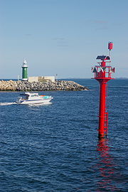
to pass. Preferably there are few obstructions such as rocks or trees to avoid. Bridges must have sufficient clearance. High water speed may make a channel
Channel (geography)
In physical geography, a channel is the physical confine of a river, slough or ocean strait consisting of a bed and banks.A channel is also the natural or human-made deeper course through a reef, sand bar, bay, or any shallow body of water...
unnavigable. Waters may be unnavigable because of ice, particularly in winter. Navigability depends on context: A small river may be navigable by smaller craft, such as a motor boat or a kayak
Kayak
A kayak is a small, relatively narrow, human-powered boat primarily designed to be manually propelled by means of a double blade paddle.The traditional kayak has a covered deck and one or more cockpits, each seating one paddler...
, but unnavigable by a cruise ship. Shallow rivers may be made navigable by the installation of locks that increase and regulate water depth, or by dredging.
Inland water transport systems
Inland Water Transport (IWT) Systems have been used for centuries in countries including IndiaIndia
India , officially the Republic of India , is a country in South Asia. It is the seventh-largest country by geographical area, the second-most populous country with over 1.2 billion people, and the most populous democracy in the world...
, China
China
Chinese civilization may refer to:* China for more general discussion of the country.* Chinese culture* Greater China, the transnational community of ethnic Chinese.* History of China* Sinosphere, the area historically affected by Chinese culture...
, Egypt
Egypt
Egypt , officially the Arab Republic of Egypt, Arabic: , is a country mainly in North Africa, with the Sinai Peninsula forming a land bridge in Southwest Asia. Egypt is thus a transcontinental country, and a major power in Africa, the Mediterranean Basin, the Middle East and the Muslim world...
, the Netherlands
Netherlands
The Netherlands is a constituent country of the Kingdom of the Netherlands, located mainly in North-West Europe and with several islands in the Caribbean. Mainland Netherlands borders the North Sea to the north and west, Belgium to the south, and Germany to the east, and shares maritime borders...
, the United States, Germany
Germany
Germany , officially the Federal Republic of Germany , is a federal parliamentary republic in Europe. The country consists of 16 states while the capital and largest city is Berlin. Germany covers an area of 357,021 km2 and has a largely temperate seasonal climate...
, China
China
Chinese civilization may refer to:* China for more general discussion of the country.* Chinese culture* Greater China, the transnational community of ethnic Chinese.* History of China* Sinosphere, the area historically affected by Chinese culture...
, and Bangladesh
Bangladesh
Bangladesh , officially the People's Republic of Bangladesh is a sovereign state located in South Asia. It is bordered by India on all sides except for a small border with Burma to the far southeast and by the Bay of Bengal to the south...
. In the Netherlands, IWT handles 46% of the nation's inland freight; 32% in Bangladesh
Bangladesh
Bangladesh , officially the People's Republic of Bangladesh is a sovereign state located in South Asia. It is bordered by India on all sides except for a small border with Burma to the far southeast and by the Bay of Bengal to the south...
, 14% in the United States, and 9% in China
China
Chinese civilization may refer to:* China for more general discussion of the country.* Chinese culture* Greater China, the transnational community of ethnic Chinese.* History of China* Sinosphere, the area historically affected by Chinese culture...
.
In the United States

Navigable waters of the United States, as defined in 33 CFR 329, are those waters that are subject to the ebb and flow of the tide and/or are presently used, or have been used in the past, or may be susceptible for use to transport interstate or foreign commerce while the waterway is in its ordinary condition. Section 10 of the Rivers and Harbors Act of 1899
Rivers and Harbors Act of 1899
The Rivers and Harbors Appropriation Act of 1899 is the oldest federal environmental law in the United States. The Act makes it a misdemeanor to discharge refuse matter of any kind into the navigable waters, or tributaries thereof, of the United States without a permit; this specific provision is...
(33 U.S.C. 403), approved 3 March 1899, prohibits the unauthorized obstruction of a navigable water of the U.S. This statute also requires a permit from the U.S. Army Corps of Engineers for any construction in or over any navigable water, or the excavation or discharge of material into such water, or the accomplishment of any other work affecting the course, location, condition, or capacity of such waters.
Also, the Clean Water Act
Clean Water Act
The Clean Water Act is the primary federal law in the United States governing water pollution. Commonly abbreviated as the CWA, the act established the goals of eliminating releases of high amounts of toxic substances into water, eliminating additional water pollution by 1985, and ensuring that...
use the terms "traditional navigable waters," and "waters of the United States" to define Federal agency jurisdiction under the Clean Water Act. Here, "Waters of the United States" include not only navigable waters, but also waters with "a significant nexus to navigable waters"; both are covered under the Clean Water Act. The terms "navigable" and "significant nexus" are still open to judicial interpretation as indicated in two U.S. Supreme Court decisions: "Carabell v. United States" and "Rapanos v. United States
Rapanos v. United States
Rapanos v. United States, 547 U.S. 715 , was a United States Supreme Court case challenging federal jurisdiction to regulate isolated wetlands under the Clean Water Act. It was the first major environmental case heard by the newly appointed Chief Justice, John Roberts and Associate Justice, Samuel...
".
Inland water transport system in India
In India there are currently three National Waterways totaling a distance of 2921 km. They are:- HaldiaHaldiaHaldia has a typical moderate climate with winter temperatures ranging from a low of around 7 degrees Celsius to a high of 22 degrees Celsius. Winters are chilly and is when the residents hold the Haldia Utsav festival. Summers can be very hot and humid. Usual summer temperatures in May, the...
AllahabadAllahabadAllahabad , or Settled by God in Persian, is a major city of India and is one of the main holy cities of Hinduism. It was renamed by the Mughals from the ancient name of Prayaga , and is by some accounts the second-oldest city in India. It is located in the north Indian state of Uttar Pradesh,...
stretch of the Ganges Bhagirathi Hooghly river system (1620 km) in October 1986 as National Waterway 1 - Saidiya Dhubri stretch of the Brahmaputra riverBrahmaputra RiverThe Brahmaputra , also called Tsangpo-Brahmaputra, is a trans-boundary river and one of the major rivers of Asia. It is the only Indian river that is attributed the masculine gender and thus referred to as a in Indo-Aryan languages and languages with Indo-Aryan influence...
system (891 km) in September, 1988 as National Waterway 2 - KollamKollamKollam , often anglicized as ', is a city in the Indian state of Kerala. The city lies on the banks of Ashtamudi Lake on the Arabian sea coast and is situated about north of the state capital, Thiruvananthapuram...
-KottapuramKottapuramKottapuram is a part of the Thrissur district and at the southernmost border of the Kodungallur municipality. The Roman Catholic Diocese of Kottapuram which is a suffragan of the Archdiocese of Verapoly, has its see here....
(in KeralaKeralaor Keralam is an Indian state located on the Malabar coast of south-west India. It was created on 1 November 1956 by the States Reorganisation Act by combining various Malayalam speaking regions....
) stretch of West Coast Canal (410 km) along with Champakara canal and Udyogmandal canal in February, 1993 as National Waterway 3
It is estimated that the total navigable length of inland waterways is 14500 km. A total of 16 million tonnes of freight is moved by this mode of transport.
Advantages of inland water transport systems
Waterways provide enormous advantages as a mode of transport compared to land and air modes of transports.- Cheaper capital cost - Nature has already done the initial engineering work for the transportation infrastructure. Thanks to this gift of nature, the cost of developing an inland waterway is 5-10% of the cost developing an equivalent railway or a four-lane expressway.
- Cheaper maintenance cost - The maintenance cost of an inland waterway is only 20% of the maintenance cost of an equivalent roadway.
- Greater fuel efficiency (low cost of transportation) - It is estimated that 1 liter of fuel can move 105 ton-km by inland water transport. Whereas the same amount of fuel can move only 85 ton-km by rail and 24 ton-km by road. By air, it is even less.
- Easy integration with sea transport - Inland water transport can easily integrated with sea transport and hence it reduces the extra cost required for land-sea or air-sea transport interface infrastructure development. It also reduces the time taken to transfer the goods to and from sea transport vessels.
Disadvantages of inland water transport systems
- Low availability of inland waterways - As mentioned above, there are numerous criteria for a water body to be navigable. Out of the total inland water body available in the world, only a very low percentage of it is potentially navigable.
- Low speed - Water transport as a whole is much slower than its road, rail, or air competitors.
See also
- CanalCanalCanals are man-made channels for water. There are two types of canal:#Waterways: navigable transportation canals used for carrying ships and boats shipping goods and conveying people, further subdivided into two kinds:...
- Inland Waterways AssociationInland Waterways AssociationThe Inland Waterways Association was formed in 1946 as a registered charity in the United Kingdom to campaign for the conservation, use, maintenance, restoration and sensitive development of British Canals and river navigations....
, UK - Inland Waterways Association of IrelandInland Waterways Association of IrelandThe Inland Waterways Association of Ireland Cumann Uiscebhealaigh Intíre na hÉireann is a registered charity and a limited company in the Republic of Ireland and also operates in Northern Ireland. It was founded in 1954 to campaign for the conservation and development of the waterways and their...
- Inland waterways of IndiaInland waterways of IndiaIndia has about 14,500 km of navigable waterways, which consists of the Ganges–Bhagirathi–Hooghly rivers, the Brahmaputra, the Barak river, the rivers in Goa, the backwaters in Kerala, inland waters in Mumbai and the deltaic regions of the Godavari - Krishna rivers...
- Inland waters of Azerbaijan
- Inland harborInland harborAn inland harbor is a harbor that is quite far away from the ocean or sea, such as Berlin, Germany or Paris, France. Inland harbors are connected to a large body of water by an important river or canal passing near the center of the city.The Danube in Europe, the Mississippi River in the United...
- Inside PassageInside PassageThe Inside Passage is a coastal route for oceangoing vessels along a network of passages which weave through the islands on the Pacific coast of North America. The route extends from southeastern Alaska, in the United States, through western British Columbia, in Canada, to northwestern Washington...
- Inland sea (geology)
- List of canals in France
- WaterwayWaterwayA waterway is any navigable body of water. Waterways can include rivers, lakes, seas, oceans, and canals. In order for a waterway to be navigable, it must meet several criteria:...