
Belfast
Encyclopedia
Belfast is the capital of and largest city
in Northern Ireland
. By population, it is the 14th biggest city in the United Kingdom
and second biggest on the island of Ireland
(after Dublin). It is the seat of the devolved government
and legislative Northern Ireland Assembly
. The city of Belfast has a population of 267,500 and lies at the heart of the Belfast urban area
, which has a population of 483,418. The Larger Urban Zone, as defined by the European Union
, has a total population 641,638. Belfast was granted city status in 1888.
Historically, Belfast has been a centre for the Irish linen
industry (earning the nickname "Linenopolis
"), tobacco production, rope-making and shipbuilding: the city's main shipbuilders, Harland and Wolff
, which built the ill-fated RMS Titanic, propelled Belfast on to the global stage in the early 20th century as the biggest and most productive shipyard in the world. Belfast played a key role in the Industrial Revolution
, establishing its place as a global industrial centre until the latter half of the 20th century.
Industrialisation and the inward migration it brought made Belfast, if briefly, the biggest city in Ireland at the turn of the 20th century and the city's industrial and economic success was cited by Ulster unionist
opponents of Home Rule as a reason why Ireland should shun devolution and later why Ulster
in particular would fight to resist it.
Today, Belfast remains a centre for industry, as well as the arts, higher education and business, a legal centre, and is the economic engine of Northern Ireland. The city suffered greatly during the period of conflict called The Troubles
, but latterly has undergone a sustained period of calm, free from the intense political violence of former years, and substantial economic and commercial growth. Belfast city centre
has undergone considerable expansion and regeneration in recent years, notably around Victoria Square.
Belfast is served by two airports: George Best Belfast City Airport
in the city, and Belfast International Airport
15 miles (24 km) west of the city. Belfast is also a major seaport, with commercial and industrial docks dominating the Belfast Lough
shoreline, including the famous Harland and Wolff shipyard. Belfast is a constituent city of the Dublin-Belfast corridor
, which has a population of three million, or half the total population of the island of Ireland.
Béal Feirsde, which was later spelled Béal Feirste. The word béal means "mouth" or "rivermouth" while feirsde/feirste is the genitive singular of fearsaid and refers to a sandbar
or tidal ford
across a river's mouth. The name would thus translate literally as "(river)mouth of the sandbar" or "(river)mouth of the ford". This sandbar was formed at the confluence of two rivers at what is now Donegall Quay: the Lagan
, which flows into Belfast Lough
, and its tributary the Farset
. This area was the hub around which the original settlement developed. The Irish name Béal Feirste is shared by a townland
in County Mayo
, whose name has been anglicised as Belfarsad.
An alternative interpretation of the name is "mouth of [the river] of the sandbar", an allusion to the River Farset, which flows into the Lagan where the sandbar was located. This interpretation was favoured by Edmund Hogan
and John O'Donovan
. It seems clear, however, that the river itself was also named after the tidal crossing.
of Belfast was created when it was granted city status by Queen Victoria
in 1888, the city continues to be viewed as straddling County Antrim
and County Down
.
. The Giant's Ring
, a 5,000-year-old henge
, is located near the city, and the remains of Iron Age
hill fort
s can still be seen in the surrounding hills. Belfast remained a small settlement of little importance during the Middle Ages
. John de Courcy
built a castle on what is now Castle Street in the city centre in the 12th century, but this was on a lesser scale and not as strategically important as Carrickfergus Castle
to the north, which was built by de Courcy in 1177. The O'Neill
clan had a presence in the area. In the 14th century, Clan Aedh Buidh, descendants of Hugh O'Neill built Grey Castle at Castlereagh, now in the east of the city. Conn O'Neill also owned land in the area, one remaining link being the Conn's Water river flowing through east Belfast.
, which was initially settled by Protestant English and Scottish migrants at the time of the Plantation of Ulster
. (Belfast and County Antrim, however, did not form part of this particular Plantation scheme as they were privately colonised.) In 1791, the Society of United Irishmen was founded in Belfast, after Henry Joy McCracken
and other prominent Presbyterians from the city invited Theobald Wolfe Tone
and Thomas Russell
to a meeting, after having read Tone's "Argument on Behalf of the Catholics of Ireland". Evidence of this period of Belfast's growth can still be seen in the oldest areas of the city, known as the Entries
.
Belfast blossomed as a commercial and industrial centre in the 18th and 19th centuries and became Ireland's pre-eminent industrial city. Industries thrived, including linen
, rope-making, tobacco, heavy engineering and shipbuilding, and at the end of the 19th century, Belfast briefly overtook Dublin the largest city in Ireland. The Harland and Wolff
shipyards became one of the largest shipbuilders in the world, employing up to 35,000 workers. In 1886 the city suffered intense riots
over the issue of home rule, which had divided the city.
In 1920–22, Belfast became the capital of the new entity of Northern Ireland as the island of Ireland was partitioned. The accompanyinging conflict (the Irish War of Independence
) cost up to 500 lives in Belfast, the bloodiest sectarian strife in the city until the "Troubles" of the late 1960s onwards.
Belfast was heavily bombed
during World War II
. In one raid, in 1941, German bombers killed around one thousand people and left tens of thousands homeless. Outside of London, this was the greatest loss of life in a night raid during the Blitz
.
. It had been the scene of various episodes of sectarian conflict between its Roman Catholic
and Protestant
populations. These opposing groups in this conflict are now often termed republican
and loyalist
respectively, although they are also referred to as 'nationalist
' and 'unionist'. The most recent example of this conflict was known as the Troubles
– a civil conflict that raged from around 1969 to the late 1990s. Belfast saw some of the worst of the Troubles in Northern Ireland, particularly in the 1970s, with rival paramilitary groups formed on both sides. Bombing, assassination and street violence formed a backdrop to life throughout the Troubles. The Provisional IRA detonated 22 bombs within the confines of Belfast city centre in 1972, on what is known as "Bloody Friday
", killing nine people. Loyalist paramilitaries including the Ulster Volunteer Force (UVF) and the Ulster Defence Association
(UDA) claimed that the killings they carried out were in retaliation for the IRA campaign. Most of their victims were Roman Catholics with no links to the Provisional IRA. A particularly notorious group, based on the Shankill Road in the mid 1970s, became known as the Shankill Butchers
. In all, over 1,500 people were killed in political violence in the city from 1969 until 2001. Part of the legacy of the Troubles
is that both republican and loyalist paramilitary groups in Belfast have become involved in organised crime and racketeering
.
by James I
in 1613 and official city status
by Queen Victoria
in 1888. Since 1973 it has been a local government district
under local administration by Belfast City Council
. Belfast is represented in both the British House of Commons
and in the Northern Ireland Assembly
. For elections to the European Parliament
, Belfast is within the Northern Ireland constituency
.
 Belfast City Council is the local authority
with responsibility for the city. The city's elected officials are the Lord Mayor of Belfast
, Deputy Lord Mayor and High Sheriff
who are elected from among 51 councillors. The first Lord Mayor of Belfast was Daniel Dixon, who was elected in 1892. The current Lord Mayor
is Niall Ó Donnghaile of Sinn Féin
, while the Deputy Lord Mayor is Ruth Patterson of the Democratic Unionist Party
, both of whom were elected in May 2011 to serve a one year term. The Lord Mayor's duties include presiding over meetings of the council, receiving distinguished visitors to the city, and representing and promoting the city on the national and international stage.
In 1997, Unionists
lost overall control of Belfast City Council for the first time in its history, with the Alliance Party of Northern Ireland
gaining the balance of power between Nationalists
and Unionists. This position was confirmed in the three subsequent council elections, with mayors from Nationalist Sinn Féin
and Social Democratic and Labour Party
(SDLP), and the cross-community Alliance Party regularly elected since. The first nationalist Lord Mayor of Belfast was Alban Maginness of the SDLP, in 1997.
The last elections to Belfast City Council were held on 5 May 2011, with the City's voters electing fifty-one councillors across nine district electoral areas
. The election saw Nationalist councillors outnumber Unionist councillors for the first time, with Sinn Féin becoming the largest party: 16(+2) Sinn Féin
, 15(-) Democratic Unionist Party
(DUP), 8(-) SDLP
, 6(+2) Alliance Party
, 3(-4) Ulster Unionist Party
(UUP), 2 Progressive Unionist Party
(PUP), and 1 Independent (a former deputy mayor who takes the UUP whip was a member of the defunct loyalist
paramilitary linked-Ulster Democratic Party
).
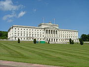
at Stormont
, the site of the devolved legislature for Northern Ireland. Belfast is divided into four Northern Ireland Assembly
and UK parliamentary
constituencies: North Belfast
, West Belfast
, South Belfast
and East Belfast
. All four extend beyond the city boundaries to include parts of Castlereagh, Lisburn
and Newtownabbey
districts. In the Northern Ireland Assembly Elections in 2007
, Belfast elected 24 Members of the Legislative Assembly (MLAs), 6 from each constituency. The MLA breakdown consisted of 8 Sinn Féin
, 6 DUP
, 4 SDLP
, 3 UUP
, 2 Alliance Party
, and 1 PUP
. In the 2005 UK general election, Belfast elected one MP from each constituency to the House of Commons
at Westminster, London
. This comprised 1 DUP, 1 SDLP, 1 Alliance and 1 Sinn Féin
.
motto "." This is taken from Psalm
116 Verse 12 in the Latin Vulgate Bible
and is literally "For (Pro) so much (tanto) what (quid) we shall repay (retribuamus)" The verse has been translated in bibles differently – for example as "What shall I render unto the Lord for all his benefits toward me?". It is also translated as "In return for so much, what shall we give back?" The Queen's University Students' Union Rag Week publication PTQ derives its name from the first three words of the motto.
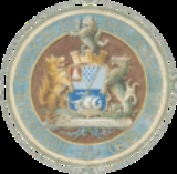
The coat of arms
of the city are blazoned as Party per fesse argent and azure, in chief a pile vair and on a canton gules a bell argent, in base a ship with sails set argent on waves of the sea proper. This heraldic language describes a shield that is divided in two horizontally (party per fesse). The top (chief) of the shield is silver (argent), and has a point-down triangle (a pile) with a repeating blue-and-white pattern that represents fur (vair). There is also a red square in the top corner (a canton gules) on which there is a silver bell. It is likely that the bell is an example here of "canting" (or punning) heraldry, representing the first syllable of Belfast. In the lower part of the shield (in base) there is a silver sailing ship shown sailing on waves coloured in the actual colours of the sea (proper). The supporter on the "dexter" side (that is, the viewer's left) is a chained wolf, while on the "sinister" side the supporter is a sea-horse. The crest above the shield is also a sea-horse. These arms date back to 1613, when King James I
granted Belfast town status. The seal was used by Belfast merchants throughout the 17th century on their signs and trade-coins. A large stained glass window in the City Hall
displays the arms, where an explanation suggests that the seahorse and the ship refer to Belfast's significant maritime history. The wolf may be a tribute to the city's founder, Sir Arthur Chichester, and refer to his own coat of arms.
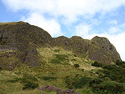 The city is flanked to the northwest by a series of hills, including Cavehill
. Belfast is located at the western end of Belfast Lough
and at the mouth of the River Lagan
making it an ideal location for the shipbuilding industry that once made it famous. When the Titanic was built in Belfast in 1911/1912, Harland and Wolff
had the largest shipyard in the world.
Belfast is situated on Northern Ireland
's eastern coast
at 54°35′49"N 05°55′45"W. A consequence of this northern latitude is that it both endures short winter days and enjoys long summer evenings. During the winter solstice
, the shortest day of the year, local sunset is before 16:00 while sunrise is around 08:45. This is balanced by the summer solstice
in June, when the sun sets after 22:00 and rises before 05:00.
In 1994, a weir
was built across the river by the Laganside Corporation
to raise the average water level so that it would cover the unseemly mud flats which gave Belfast its name . The area of Belfast Local Government District is 42.3 square miles (109.6 km²).
The River Farset
is also named after this silt
deposit (from the Irish feirste meaning "sand spit"). Originally a more significant river than it is today, the Farset formed a dock on High Street until the mid 19th century. Bank Street in the city centre
referred to the river bank and Bridge Street was named for the site of an early Farset bridge. However, superseded by the River Lagan
as the more important river in the city, the Farset now languishes in obscurity, under High Street.
The city is flanked on the north and northwest by a series of hills, including Divis Mountain
, Black Mountain
and Cavehill
thought to be the inspiration for Jonathan Swift
's Gulliver's Travels
. When Swift was living at Lilliput Cottage near the bottom of the Limestone Road in Belfast, he imagined that the Cavehill
resembled the shape of a sleeping giant safeguarding the city. The shape of the giant's nose, known locally as Napoleon's Nose, is officially called McArt's Fort probably named after Art O'Neill, a 17th century chieftain who controlled the area at that time. The Castlereagh Hills overlook the city on the southeast.
Former poet and Catholic Bishop of Down and Connor, Dr William Philbin wrote this of Belfast: "Belfast is a city walled in by mountains, moated by seas, and undermined by deposits of history".
climate, with a narrow range of temperatures, often windy conditions, and rainfall throughout the year. There are currently 5 weather observing stations in the Belfast area: Helens Bay, Stormont, Newforge, Castlereagh, and Ravenhill Road. Slightly further afield is Aldergrove Airport.
The highest temperature recorded at any official weather station in the Belfast area was 30.8 °C (87.4 °F) at Shaws Bridge on 12 July 1983. This is also the highest temperature recorded across Northern Ireland
. Belfast also holds the record for Northern Irelands warmest night time minimum, 19.6 °C (67.3 °F) at Whitehouse on the 14th August 2001.
The city gets significant precipitation (greater than 0.01 in/0.25 mm) on 213 days in an average year with an average annual rainfall of 846 millimetres (33.3 in), less than the Lake District or the Scottish Highlands
, but higher than Dublin or the south-east coast of Ireland. As an urban and coastal area, Belfast typically gets snow on fewer than 10 days per year.
The city is also renowned for how mild it is during the winter months despite its high latitude.
The absolute maximum temperature at the weather station at Stormont is 29.7 °C (85.5 °F), set during July 1983. In an average year the warmest day will rise to a temperature of 24.4 °C (75.9 °F) with a day of 25.1 °C (77.2 °F) or above occurring roughly once every two in three years.
The absolute minimum temperature at Stormont is -9.9 C, during January 1982, although in an average year the coldest night will fall no lower than -4.5 C with air frost being recorded on just 26 nights. The lowest temperature to occur in recent years was -8.8 on the 22nd December 2010.
The nearest weather station for which sunshine data and longer term observations are available is Belfast International Airport
(Aldergrove
). Perhaps not surprisingly, temperature extremes here have slightly more variability due to the more inland location. The average warmest day at Aldergrove for example will reach a temperature of 25.4 °C (77.7 °F), (1.0 celsius higher than Stormont) and 2.1 days should attain a temperature of 25.1 °C (77.2 °F) or above in total. Conversely the coldest night of the year averages -6.6 C (or 1.9 celius lower the Stormont) and 39 nights should register an air frost. -Some 13 more frosty nights than Stormont.
 Belfast expanded very rapidly from being a market town to becoming an industrial city during the course of the 19th century. Because of this, it is less an agglomeration of villages and towns which have expanded into each other, than other comparable cities, such as Manchester
or Birmingham
. The city expanded to the natural barrier of the hills that surround it, overwhelming other settlements. Consequently, the arterial roads along which this expansion took place (such as the Falls Road or the Newtownards Road) are more significant in defining the districts of the city than nucleated settlements. Belfast remains segregated by walls, commonly known as "peace lines
", erected by the British Army
after August 1969, and which still divide 14 districts in the inner city.
In 2008 a process was proposed for the removal of the 'peace walls'. In June 2007, a UK£
16 million programme was announced which will transform and redevelop streets and public spaces in the city centre. Major arterial roads (quality bus corridor
) into the city include the Antrim Road, Shore Road, Holywood Road, Newtownards Road, Castlereagh Road, Cregagh Road, Ormeau Road, Malone Road
, Lisburn Road
, Falls Road, Springfield Road, Shankill Road, and Crumlin Road.
Belfast city centre
is divided by two postcodes, BT1 for the area lying north of the City Hall
, and BT2 for the area to its south. The industrial estate and docklands share BT3. The rest of the Greater Belfast postcodes
are set out in a clockwise
system. Although BT stands for Belfast, it is used across the whole of Northern Ireland.
Since 2001, boosted by increasing numbers of tourists, the city council has developed a number of cultural quarters
. The Cathedral Quarter
takes its name from St Anne's Cathedral (Church of Ireland) and has taken on the mantle of the city's key cultural locality. It hosts a yearly visual and performing arts festival
.
Custom House Square is one of the city's main outdoor venues for free concerts and street entertainment. The Gaeltacht Quarter
is an area around the Falls Road in west Belfast which promotes and encourages the use of the Irish language
. The Queen's Quarter
in south Belfast is named after Queen's University. The area has a large student population and hosts the annual Belfast Festival at Queen's
each autumn. It is home to Botanic Gardens
and the Ulster Museum
, which was reopened in 2009 after major redevelopment. The Golden Mile
is the name given to the mile between Belfast City Hall
and Queen's University. Taking in Dublin Road, Great Victoria Street, Shaftesbury Square and Bradbury Place, it contains some of the best bars and restaurants in the city. Since the Good Friday Agreement
in 1998, the nearby Lisburn Road
has developed into the city's most exclusive shopping strip. Finally, the Titanic Quarter
covers 0.75 km² (0.289576618944401 sq mi) of reclaimed land adjacent to Belfast Harbour
, formerly known as Queen's Island. Named after the Titanic, which was built here in 1912, work has begun which promises to transform some former shipyard land into "one of the largest waterfront developments in Europe". Plans also include apartments, a riverside entertainment district, and a major Titanic-themed museum.
 The architectural style of Belfast's buildings range from Edwardian
, like the City Hall
, to modern, like Waterfront Hall
. Many of the city's Victorian
landmarks, including the main Lanyon Building at Queen's University Belfast and the Linenhall Library, were designed by Sir Charles Lanyon
.
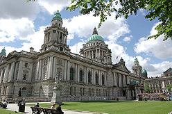
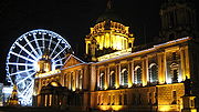
The City Hall
was finished in 1906 and was built to reflect Belfast's city status, granted by Queen Victoria
in 1888. The Edwardian
architectural influenced the Victoria Memorial
in Calcutta, India, and Durban
City Hall in South Africa. The dome is 173 ft (53 m) high and figures above the door state "Hibernia
encouraging and promoting the Commerce and Arts of the City". Among the city's grandest buildings are two former banks: Ulster Bank
in Waring Street (built in 1860) and Northern Bank
, in nearby Donegall Street (built in 1769). The Royal Courts of Justice
in Chichester Street are home to Northern Ireland's Supreme Court
. Many of Belfast's oldest buildings are found in the Cathedral Quarter
area, which is currently undergoing redevelopment as the city's main cultural and tourist area. Windsor House, 262 ft (80 m) high, has 23 floors and is the second tallest building (as distinct from structure) in Ireland. Work has started on the taller Obel Tower
, which already surpasses the height of Windsor House in its unfinished state. In 2007, plans were approved for the Aurora building
. At 37 storeys and 358 ft (109 m) high, this will surpass both previous buildings.
The ornately decorated Crown Liquor Saloon
, designed by Joseph Anderson in 1876, in Great Victoria Street is the only bar in the UK owned by the National Trust. It was made internationally famous as the setting for the classic film, Odd Man Out
, starring James Mason
. The restaurant panels in the Crown Bar were originally made for Britannic, the sister ship of the Titanic, built in Belfast. The Harland and Wolff
shipyard is now the location of the world's largest dry dock
, where the giant cranes, Samson and Goliath
stand out against Belfast's skyline.
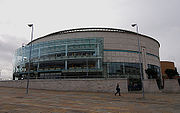
Including the Waterfront Hall
and the Odyssey Arena, Belfast has several other venues for performing arts. The architecture of the Grand Opera House
has a distinctly oriental theme and was completed in 1895. It was bombed several times during the Troubles
but has now been restored to its former glory. The Lyric Theatre
, (currently undergoing a rebuilding programme) the only full-time producing theatre in the country, is where film star Liam Neeson
began his career. The Ulster Hall
(1859–1862) was originally designed for grand dances but is now used primarily as a concert and sporting venue. Lloyd George
, Parnell
and Patrick Pearse
all attended political rallies there.
Parks and Gardens are an integral part of Belfast's heritage, and home to an abundance of local wildlife and popular places for a picnic, a stroll or a jog. Numerous events take place throughout including festivals such as Rose Week and special activities such as bird watching evenings and great beast hunts.
Belfast has over forty public parks. The Forest of Belfast is a partnership between government and local groups, set up in 1992 to manage and conserve the city's parks and open spaces. They have commissioned more than 30 public sculptures since 1993. In 2006, the City Council
set aside UK£
8 million to continue this work. The Belfast Naturalists' Field Club
was founded in 1863 and is administered by National Museums and Galleries of Northern Ireland.
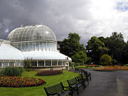 With 700,000 visitors in 2005, one of the most popular parks is Botanic Gardens
in the Queen's Quarter
. Built in the 1830s and designed by Sir Charles Lanyon
, Botanic Gardens Palm House is one of the earliest examples of a curvilinear and cast iron glasshouse
. Other attractions in the park include the Tropical Ravine, a humid jungle glen built in 1889, rose gardens and public events ranging from live opera broadcasts to pop concerts. U2
played here in 1997. Sir Thomas and Lady Dixon Park
, to the south of the city centre, attracts thousands of visitors each year to its International Rose Garden. Rose Week in July each year features over 20,000 blooms. It has an area of 128 acre (0.51799808 km²) of meadows, woodland and gardens and features a Princess Diana
Memorial Garden, a Japanese Garden, a walled garden, and the Golden Crown Fountain commissioned in 2002 as part of the Queen's Golden Jubilee
celebrations.
In 2008, Belfast was named a finalist in the Large City (200,001 and over) category of the RHS
Britain in Bloom
competition along with London Borough of Croydon
and Sheffield
.
Belfast Zoo
is owned by Belfast City Council. The council spends £1.5 million every year on running and promoting the zoo, which is one of the few local government-funded zoos in the UK and Ireland. The Zoo is one of the top visitor attraction in Northern Ireland, receiving more than 295,000 visitors a year. The majority of the animals are in danger in their natural habitat. The zoo houses more than 1,200 animals of 140 species including Asian Elephant
s, Barbary Lions
, a White Tigers
(one of the few in the United Kingdom
), three species of penguin
, a family of Western Lowland Gorilla
s, a troop of Common Chimpanzee
s, a Red Panda
and several species of langur. The zoo also carries out important conservation work and takes part in European and international breeding programmes which help to ensure the survival of many species under threat.
. This made it the fifteenth-largest city in the United Kingdom, but the eleventh-largest conurbation.
Belfast experienced a huge growth in population
around the first half of the twentieth century. This rise slowed and peaked around the start of the Troubles
with the 1971 census showing almost 600,000 people in the Belfast Urban Area. Since then, the inner city numbers have dropped dramatically as people have moved to swell the Greater Belfast
suburb population. The 2001 census population within the same Urban Area, had fallen to 277,391 people, with 579,554 people living in the wider Belfast Metropolitan Area
. The population density in the same year was 2,415 people/km² (compared to 119 for the rest of Northern Ireland). As with many cities, Belfast's inner city is currently characterised by the elderly, students and single young people, while families tend to live on the periphery. Socio-economic areas radiate out from the Central Business District
, with a pronounced wedge of affluence extending out the Malone Road
and Upper Malone Road to the south. An area of greater deprivation extends to the west of the city. The areas around the Falls and Shankill Roads are the most deprived wards in Northern Ireland.
Despite a period of relative peace, most areas and districts of Belfast still reflect the divided nature of Northern Ireland as a whole. Many areas are still highly segregated along ethnic, political and religious lines, especially in working class
neighbourhoods. These zones – 'Catholic
' or 'Republican
' on one side and 'Protestant
', or 'Loyalist
' on the other – are invariably marked by flags
, graffiti
and murals
. Segregation has been present throughout the history of Belfast, but has been maintained and increased by each outbreak of violence in the city. This escalation in segregation, described as a "ratchet effect", has shown little sign of decreasing during times of peace. When violence flares, it tends to be in interface areas. The highest levels of segregation in the city are in west Belfast with many areas greater than 90% Catholic
. Opposite but comparatively high levels are seen in the predominantly Protestant
east Belfast. Areas where segregated working-class areas meet are known as interface area
s.
Ethnic minority
communities have been in Belfast since the 1930s. The largest groups are Chinese and Irish travellers (traditionally not classed as an ethnic minority in Ireland but a social group as they share the same genetic origin as native Irish). Since the expansion of the European Union, numbers have been boosted by an influx of Eastern European immigrants. Census figures (2001) showed that Belfast has a total ethnic minority population of 4,584 or 1.3% of the population. Over half of these live in south Belfast, where they comprise 2.63% of the population. The majority of the estimated 5,000 Muslims and 200 Hindu
families living and working in Northern Ireland live in the Greater Belfast
area...
in 1998 have given investors increased confidence to invest in Belfast. This has led to a period of sustained economic growth and large-scale redevelopment of the city centre
. Developments include Victoria Square
, the Cathedral Quarter
, and the Laganside with the Odyssey
complex and the landmark Waterfront Hall
. Other major developments include the regeneration of the Titanic Quarter
, and the erection of the Obel Tower
, a skyscraper set to be the tallest tower on the island.
Today, Belfast is Northern Ireland's educational and commercial hub. In February 2006, Belfast's unemployment rate stood at 4.2%, lower than both the Northern Ireland and the UK average of 5.5%. Over the past 10 years employment has grown by 16.4 per cent, compared with 9.2 per cent for the UK as a whole.
Northern Ireland's peace dividend
has led to soaring property prices in the city. In 2007, Belfast saw house prices grow by 50%, the fastest rate of growth in the UK. In March 2007, the average house in Belfast cost £91,819, with the average in south Belfast being £141,000. In 2004, Belfast had the lowest owner occupation rate in Northern Ireland at 54%.
Peace has also boosted the numbers of tourists coming to Belfast. There were 6.4 million visitors in 2005, which was a growth of 8.5% from 2004. The visitors spent £285.2 million, supporting more than 15,600 jobs. Visitor numbers rose by 6% to reach 6.8 million in 2006, with tourists spending £324 million, an increase of 15% on 2005. The city's two airports have helped make the city one of the most visited weekend destinations in Europe.
Belfast has been the fastest-growing economy of the thirty largest British cities over the past decade, a new economy report by Howard Spencer has found. "That's because [of] the fundamentals of the UK economy and [because] people actually want to invest in the UK," he commented on that report.
BBC
Radio 4's World reported furthermore that despite higher levels of corporation tax in the UK than in the Republic. There are "huge amounts" of foreign investment coming into the country.
The Times
wrote about Belfast's growing economy: "According to the region's development agency, throughout the 1990s Northern Ireland had the fastest-growing regional economy in the UK, with GDP increasing 1 per cent per annum faster than the rest of the country. As with any modern economy, the service sector is vital to Northern Ireland's development and is enjoying excellent growth. In particular, the region has a booming tourist industry with record levels of visitors and tourist revenues and has also established itself as a significant location for call centres."
Since the ending of the regions conflict tourism has boomed in Northern Ireland, greatly aided by low cost.
Der Spiegel
, a German weekly magazine for politics and economy, titled Belfast as The New Celtic Tiger which is "open for business".
 When the population of Belfast town began to grow in the 17th century, its economy was built on commerce
. It provided a market for the surrounding countryside and the natural inlet of Belfast Lough
gave the city its own port
. The port supplied an avenue for trade with Great Britain and later Europe and North America. In the mid-17th century, Belfast exported beef, butter, hides, tallow and corn and it imported coal, cloth, wine, brandy, paper, timber and tobacco. Around this time, the linen
trade in Northern Ireland blossomed and by the middle of the 18th century, one fifth of all the linen exported from Ireland was shipped from Belfast. The present city however is a product of the Industrial Revolution
. It was not until industry transformed the linen and shipbuilding trades that the economy and the population boomed. By the turn of the 19th century, Belfast had transformed into the largest linen producing centre in the world, earning the nickname "Linenopolis
".
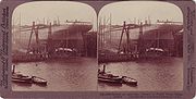
Belfast harbour was dredged in 1845 to provide deeper berths for larger ships. Donegall Quay was built out into the river as the harbour was developed further and trade flourished. The Harland and Wolff
shipbuilding firm was created in 1861, and by the time the Titanic was built in Belfast in 1912 it had become the largest shipyard in the world.
 Short Brothers
plc is a British aerospace company based in Belfast. It was the first aircraft manufacturing company in the world. The company began its association with Belfast in 1936, with Short & Harland Ltd, a venture jointly owned by Shorts and Harland and Wolff. Now known as Shorts Bombardier it works as an international aircraft manufacturer located near the Port of Belfast
. The rise of mass-produced and cotton clothing following World War I
were some of the factors which led to the decline of Belfast's international linen trade. Like many British cities dependent on traditional heavy industry, Belfast suffered serious decline since the 1960s, exacerbated greatly in the 1970s and 1980s by The Troubles
. More than 100,000 manufacturing jobs have been lost since the 1970s. For several decades, Northern Ireland's fragile economy required significant public support from the British exchequer
of up to UK£
4 billion per year. Ongoing sectarian violence has made it difficult for Belfast to compete with Dublin's Celtic Tiger
economy. This has meant that wage rates in Belfast and Northern Ireland until recently were significantly lower than those in the Republic of Ireland. The effect of the economic depression in the Irish Republic on wage levels is not yet fully apparent. The cost of living in Northern Ireland is significantly lower than in the Republic and this has created a retail boom in border towns and cities.
in Northern Ireland, with nearly half of the total deaths in the conflict occurring in the city. However, since the Good Friday Agreement
in 1998, there has been significant urban regeneration in the city centre
including Victoria Square, Queen's Island
and Laganside as well as the Odyssey
complex and the landmark Waterfront Hall
. The city is served by two airports: The George Best Belfast City Airport
adjacent to Belfast Lough and Belfast International Airport
which is near Lough Neagh
. Queen's University of Belfast
is the main university in the city. The University of Ulster
also maintains a campus in the city, which concentrates on fine art, design and architecture.
Belfast is one of the constituent cities that makes up the Dublin-Belfast corridor
region, which has a population of just under 3 million.
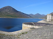 Most of Belfast's water is supplied from the Silent Valley Reservoir
in County Down
, created to collect water from the Mourne Mountains. The rest of the city's water is sourced from Lough Neagh
, via Dunore Water Treatment Works in County Antrim. The citizens of Belfast pay for their water in their rates
bill. Plans to bring in additional water tariffs have been deferred by devolution
in May 2007. Belfast has approximately 1300 km (808 mi) of sewers
, which are currently being replaced in a project costing over UK£
100 million and due for completion in 2009.
Northern Ireland Electricity
is responsible for transmitting electricity in Northern Ireland. Belfast's electricity comes from Kilroot
Power Station, a 520 megawatt dual coal
and oil
fired plant
, situated near Carrickfergus
. Phoenix Natural Gas Ltd.
has been granted the licence for the transportation of natural gas across the Irish Sea from Stranraer
to supply Greater Belfast from a base station near Carrickfergus
. Rates
in Belfast (and the rest of Northern Ireland) were reformed in April 2007. The discrete capital
value system means rates bills are determined by the capital value of each domestic property as assessed by the Valuation and Lands Agency. The recent dramatic rise in house prices has made these reforms unpopular.
is one of five trusts that were created on 1 April 2007 by the Department of Health
. Belfast contains most of Northern Ireland's regional specialist centres. The Royal Victoria Hospital
is an internationally-renowned centre of excellence in trauma care and provides specialist trauma care for all of Northern Ireland. It also provides the city's specialist neurosurgical, ophthalmology, ENT
, and dentistry services. The Belfast City Hospital
is the regional specialist centre for haematology and is home to a cancer centre that rivals the best in the world. The Mary G McGeown Regional Nephrology Unit at the City Hospital
is the kidney transplant centre and provides regional renal services for Northern Ireland.
Musgrave Park Hospital
in south Belfast specialises in orthopaedics, rheumatology, sports medicine and rehabilitation. It is home to Northern Ireland's first Acquired Brain Injury Unit, costing GB£
9 million and opened by the Prince of Wales
and the Duchess of Cornwall
in May 2006. Other hospitals in Belfast include the Mater Hospital
in north Belfast and the Children's Hospital
.
and M22
motorway route. A recent survey of how people travel in Northern Ireland showed that people in Belfast made 77% of all journeys by car, 11% by public transport and 6% on foot. It also showed that Belfast has 0.70 cars per household compared to figures of 1.18 in the East and 1.14 in the West of Northern Ireland. A significant road improvement-scheme in Belfast began early in 2006, with the upgrading of two junctions along the Westlink
dual-carriageway to grade-separated
standard. The improvement scheme was completed five months ahead of schedule on February 2009, with the official opening taking place on 4 March 2009. Commentators have argued that this may simply create a bottleneck at York Street, the next at-grade intersection
, until that too is upgraded. The York Street phase is currently at the review stage and if successfully completing the necessary statutory procedures, work on a grade separated junction to connect the Westlink to the M2/M3 motorways is scheduled to take place between 2013/14 to 2017/2018, creating a continuous link between the M1 and M2, the two main motorways in Northern Ireland.
Black taxis
are common in the city, operating on a share
basis in some areas. These, however, are outnumbered by private hire taxis. Bus and rail public transport
in Northern Ireland is operated by subsidiaries of Translink
. Bus services in the city proper and the nearer suburbs are operated by Translink Metro
, with services focusing on linking residential districts with the city centre on 12 quality bus corridor
s running along main radial roads, resulting in poor connections between different suburban areas. More distant suburbs are served by Ulsterbus
. Northern Ireland Railways
provides suburban services
along three lines running through Belfast's northern suburbs to Carrickfergus
and Larne
, eastwards towards Bangor
and south-westwards towards Lisburn
and Portadown
. This service is known as the Belfast Suburban Rail
system. Belfast also has a direct rail connection with Dublin called Enterprise which is operated jointly by NIR and Iarnród Éireann
, the state railway company of the Republic of Ireland
.
In April 2008, the Department for Regional Development
reported on a plan for a light-rail system, similar to that in Dublin. The consultants said Belfast does not have the population to support a light rail system, suggesting that investment in bus-based rapid transit would be preferable.The study found that bus-based rapid transit produces positive economic results, but light rail does not. The report by Atkins & KPMG, however, said there would be the option of migrating to light rail in the future should the demand increase.
The city has two airports: the Belfast International Airport
offers domestic, European and transatlantic flights and is located north-west of the city, near Lough Neagh
, while the George Best Belfast City Airport
, which is closer to the city centre, adjacent to Belfast Lough
, offers UK domestic flights and a few European flights. In 2005, Belfast International Airport was the 11th busiest commercial airport in the UK, accounting for just over 2% of all UK terminal passengers while the George Best Belfast City Airport was the 16th busiest and had 1% of UK terminal passengers. The Belfast - Liverpool route is the busiest domestic flight route in the UK excluding London with 555,224 passengers in 2009. Over 2.2 million passengers also flew between Belfast and London in 2009.
Belfast has a large port
which is used for exporting and importing goods, and for passenger ferry services. Stena Line
run regular routes to Stranraer
in Scotland using its HSS (High Speed Service) vessel – with a crossing time of around 90 minutes – and/or its conventional vessel – with a crossing time of around 3 hours 45 minutes. Norfolkline
– formally Norse Merchant Ferries – offers a passenger/cargo ferry to and from Liverpool
, with a crossing time of 8 hours and a seasonal sailing to Douglas, Isle of Man
is operated by the Isle of Man Steam Packet Company
.
and Catholic
residents. These two distinct cultural communities have both contributed significantly to the city's culture. Throughout the Troubles
, Belfast artists continued to express themselves through poetry, art and music. In the period since the Good Friday Agreement
in 1998, Belfast has begun a social, economic and cultural transformation giving it a growing international cultural reputation. In 2003, Belfast had an unsuccessful bid for the 2008 European Capital of Culture
. The bid was run by an independent company, Imagine Belfast, who boasted that it would "make Belfast the meeting place of Europe's legends, where the meaning of history and belief find a home and a sanctuary from caricature, parody and oblivion." According to The Guardian
the bid may have been undermined by the city's history
and volatile politics.
In 2004–05, art and cultural events in Belfast were attended by 1.8 million people (400,000 more than the previous year). The same year, 80,000 people participated in culture and arts activities, twice as many as in 2003–04. A combination of relative peace, international investment and an active promotion of arts and culture is attracting more tourists to Belfast than ever before. In 2004–05, 5.9 million people visited Belfast, a 10% increase from the previous year, and spent UK£
262.5 million.
The Ulster Orchestra
, based in Belfast, is Northern Ireland's only full-time symphony orchestra and is well renowned in the United Kingdom. Founded in 1966, it has existed in its present form since 1981, when the BBC Northern Ireland
Orchestra was disbanded. The music school of Queen's University is responsible for arranging a notable series of lunchtime and evening concerts, often given by renowned musicians which are usually given in The Harty Room at the university (University Square).
There are many Traditional Irish bands playing throughout the city and quite a few music schools concentrate on teaching Traditional music. Well known city centre venues would include Kelly's Cellars, Maddens and the Hercules bar. Famous artists would include The McPeakes, Brian Kennedy and the band 9Lies.
Musicians and bands who have written songs about or dedicated to Belfast:
U2
, Van Morrison
, Snow Patrol
, Simple Minds
, Elton John
, Katie Melua
, Boney M
, Paul Muldoon
, Stiff Little Fingers
, Nanci Griffith
, Glenn Patterson
, Orbital
, James Taylor
, Spandau Ballet
, The Police
, Barnbrack
, Gary Moore
Neon Neon
.
Further in Belfast the Oh Yeah Music Centre is located (Cathedral Quarter), a project founded to give young musicians and artists a place where they can share ideas and kick-start their music careers as chance to been supported and promoted by professional musicians of Northern Ireland's music-scene.
Like all areas of the island of Ireland outside of the Gaeltacht
, the Irish language in Belfast is not that of an unbroken intergenerational transmission. Due to community activity in the 1960s, including the establishment of the Shaws Road Gaeltacht community, the expanse in the Irish language arts, and the advancements made in the availability of Irish medium education throughout the city, it can now be said that there is a 'mother-tongue' community of speakers. The language is heavily promoted in the city and Belfast has the highest concentration of Irish speakers in Northern Ireland. Projects to promote the language in the city are funded by various sources, notably Foras na Gaeilge
, an all-Ireland body funded by both the Irish and British governments. There are a number Irish language Primary schools and one secondary school in Belfast. The provision of certain resources for these schools (for example, such as the provision of textbooks) is supported by the charitable organisation TACA.
 Belfast is the home of the Irish News, Belfast Telegraph, and The News Letter
, the oldest English-language
newspaper in the world still in publication. The city also contains a number of free publications including Go Belfast, Fate magazine and the Vacuum
that are distributed through bar, cafes and public venues.
The city is the headquarters of BBC Northern Ireland
, the ITV
station UTV and the commercial radio stations Belfast CityBeat
& U105
. Two community radio stations, Blast 106
and Irish language station Raidió Fáilte
broadcast to the city from west Belfast, as well as Queen's Radio
– a student-run radio station which broadcasts from Queen's University Students' Union
. One of Northern Ireland's two community TV stations NvTv
is based in the Cathedral Quarter
of the city. There are two independent cinemas in Belfast, the Queen's Film Theatre
and the Strand Cinema
, which host screenings during the Belfast Film Festival
and the Belfast Festival at Queen's
. Also broadcasting only over the Internet is the Cultural Radio Station for Northern Ireland, supporting community relations, Homely Planet.
The city has become a popular film location, with The Paint Hall at Harland and Wolff becoming one of the UK Film Council's main studios. The facility comprises four stages of 16000 square feet (1,486.4 m²). Films shot at The Paint Hall include City of Ember
. Filming for HBO's Game of Thrones
began in late 2009.
In November 2011, Belfast became the smallest city to host the MTV Europe Music Awards
. The event was hosted by Selena Gomez
and celebrities such as Justin Bieber
, Jessie J
, Hayden Panettiere
and Lady Gaga
travelled to Northern Ireland to attend the event, which was held in the Odyssey Arena.
 Watching and playing sports is an important part of Belfast culture. Almost six out of ten (59%) of the adult population in Northern Ireland
regularly participate in one or more sports. Belfast has several notable sports teams playing a diverse variety of sports including association football, rugby
, Cricket
, Gaelic games
, and ice hockey
as well as many urban sports like skateboarding, bmx and parkour/freerunning. The Belfast Marathon
is run annually on May Day, and attracted 20,000 participants in 2011. The Northern Ireland national football team
, ranked 62nd in June 2011 in the FIFA World Rankings
, and 6th in the FIFA rankings per capita in October 2008 plays its home matches in Windsor Park
. The 2010–11 Irish League
champions Linfield
are also based at Windsor Park
, in the south of the city. Other teams include 2008/09 champions Glentoran
based in east Belfast, Cliftonville
and Crusaders
in north Belfast and Donegal Celtic
in west Belfast. Belfast was the home town of the renowned player George Best
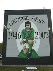
who died in November 2005. On the day he was buried in the city, 100,000 people lined the route from his home on the Cregagh Road to Roselawn cemetery. Since his death the City Airport
was named after him and a trust has been set up to fund a memorial to him in the city centre.
Gaelic football
is the most popular spectator sport in Ireland, and Belfast is home to over twenty football and hurling
clubs. Casement Park
in west Belfast, home to the Antrim
county teams, has a capacity of 32,000 which makes it the second largest Gaelic Athletic Association
ground in Ulster
. The 2006 Celtic League
champions and 1999 European Rugby Union champions
Ulster
play at Ravenhill
in south Belfast. Belfast has four teams in rugby's All-Ireland League: Belfast Harlequins
in Division 1B; and Instonians
, Queen's University
and Malone
in Division 2A.
Ice hockey
is one of Northern Ireland's most popular sports mainly down to it being home to one of the biggest British clubs, the Belfast Giants
. The Giants were founded in 2000 and play their games at the 9500 capacity Odyssey Arena
, crowds normally range from 4,000-7,000. Many ex-NHL players have featured on the Giants roster, none more famous than world superstar Theo Fleury. The Giants play in the 10 team professional Elite Ice Hockey League
which is the top league in Britain. The Belfast Giants
are a huge brand in Northern Ireland and the U.S and because of the size of the brand the Belfast Giants
will be taking on the Boston Bruins
of the NHL on the 2nd of October, 2010 at the Odyssey Arena
in Belfast.
Other significant sportspeople from Belfast include double world snooker champion Alex "Hurricane" Higgins
and world champion boxers Wayne McCullough
and Rinty Monaghan
.
Leander A.S.C is a well known swimming club in Belfast.
 Belfast has two universities. Queen's University Belfast was founded in 1845 and is a member of the Russell Group
, an association of 20 leading research-intensive universities in the UK. It is one of the largest universities in the UK with 25,231 undergraduate and postgraduate students spread over 250 buildings, 120 of which are listed as being of architectural merit. The University of Ulster
, created in its current form in 1984, is a multi-centre university with a campus in the Cathedral Quarter
of Belfast. The Belfast campus has a specific focus on Art and Design and Architecture, and is currently undergoing major redevelopment. The Jordanstown
campus, just seven miles (11 km) from Belfast city centre concentrates on engineering, health and social science. The Conflict Archive on the INternet (CAIN) Web Service receives funding from both universities and is a rich source of information and source material on the Troubles as well as society and politics in Northern Ireland.
Belfast Metropolitan College is a large further education
college with several campuses around the city. Formerly known as Belfast Institute of Further and Higher Education, it specialises in vocational education
. The college has over 53,000 students enrolled on full-time and part-time courses, making it one of the largest further education colleges in the UK.
The Belfast Education and Library Board was established in 1973 as the local authority responsible for education, youth and library services within the city. There are 184 primary
, secondary
and grammar
schools in the city.
The Ulster Museum
is also located in Belfast.
Frommer's
, the American travel guidebook series, listed Belfast as the only United Kingdom
destination in its Top 12 Destinations to Visit in 2009. The other listed destinations were Istanbul
, Berlin
, Cape Town
, Saqqara
, Washington DC, Cambodia
, Waiheke Island
, Cartagena
, Waterton Lakes National Park
, the Selma To Montgomery National Historic Trail, Alabama
and the Lassen Volcanic National Park
To further enhance the tourist industry in Northern Ireland, the Belfast City Council is currently investing into the complete redevelopment of the Titanic Quarter, which is planned to consist of apartments, hotels, a riverside entertainment district, and a major Titanic-themed attraction. They also hope to invest in a new modern transport system (high-speed rail and others) for Belfast, with a cost of £250 million.
There is also a large tourist information centre located at Donegall Place.
with:
Nashville
, USA
Bonn
, Germany
Hefei
, China
Wonju
, South Korea
City
A city is a relatively large and permanent settlement. Although there is no agreement on how a city is distinguished from a town within general English language meanings, many cities have a particular administrative, legal, or historical status based on local law.For example, in the U.S...
in Northern Ireland
Northern Ireland
Northern Ireland is one of the four countries of the United Kingdom. Situated in the north-east of the island of Ireland, it shares a border with the Republic of Ireland to the south and west...
. By population, it is the 14th biggest city in the United Kingdom
United Kingdom
The United Kingdom of Great Britain and Northern IrelandIn the United Kingdom and Dependencies, other languages have been officially recognised as legitimate autochthonous languages under the European Charter for Regional or Minority Languages...
and second biggest on the island of Ireland
Ireland
Ireland is an island to the northwest of continental Europe. It is the third-largest island in Europe and the twentieth-largest island on Earth...
(after Dublin). It is the seat of the devolved government
Northern Ireland Executive
The Northern Ireland Executive is the executive arm of the Northern Ireland Assembly, the devolved legislature for Northern Ireland. It is answerable to the Assembly and was established according to the terms of the Northern Ireland Act 1998, which followed the Good Friday Agreement...
and legislative Northern Ireland Assembly
Northern Ireland Assembly
The Northern Ireland Assembly is the devolved legislature of Northern Ireland. It has power to legislate in a wide range of areas that are not explicitly reserved to the Parliament of the United Kingdom, and to appoint the Northern Ireland Executive...
. The city of Belfast has a population of 267,500 and lies at the heart of the Belfast urban area
Greater Belfast
Greater Belfast is an area surrounding and including Belfast in Northern Ireland.It includes Belfast and parts of the North Down, Lisburn, Castlereagh and Newtownabbey district council areas. Greater Belfast is the largest urban area in Northern Ireland, and second largest in Ireland...
, which has a population of 483,418. The Larger Urban Zone, as defined by the European Union
European Union
The European Union is an economic and political union of 27 independent member states which are located primarily in Europe. The EU traces its origins from the European Coal and Steel Community and the European Economic Community , formed by six countries in 1958...
, has a total population 641,638. Belfast was granted city status in 1888.
Historically, Belfast has been a centre for the Irish linen
Linen
Linen is a textile made from the fibers of the flax plant, Linum usitatissimum. Linen is labor-intensive to manufacture, but when it is made into garments, it is valued for its exceptional coolness and freshness in hot weather....
industry (earning the nickname "Linenopolis
Linenopolis
Linenopolis was a nickname applied to Belfast, Northern Ireland in the 19th century.During the American Civil War there were disruptions to the supply of cotton reaching Europe, and during this period Irish linen experienced somewhat of a revival. There was a shortage of cotton goods on the world...
"), tobacco production, rope-making and shipbuilding: the city's main shipbuilders, Harland and Wolff
Harland and Wolff
Harland and Wolff Heavy Industries is a Northern Irish heavy industrial company, specialising in shipbuilding and offshore construction, located in Belfast, Northern Ireland....
, which built the ill-fated RMS Titanic, propelled Belfast on to the global stage in the early 20th century as the biggest and most productive shipyard in the world. Belfast played a key role in the Industrial Revolution
Industrial Revolution
The Industrial Revolution was a period from the 18th to the 19th century where major changes in agriculture, manufacturing, mining, transportation, and technology had a profound effect on the social, economic and cultural conditions of the times...
, establishing its place as a global industrial centre until the latter half of the 20th century.
Industrialisation and the inward migration it brought made Belfast, if briefly, the biggest city in Ireland at the turn of the 20th century and the city's industrial and economic success was cited by Ulster unionist
Unionism in Ireland
Unionism in Ireland is an ideology that favours the continuation of some form of political union between the islands of Ireland and Great Britain...
opponents of Home Rule as a reason why Ireland should shun devolution and later why Ulster
Ulster
Ulster is one of the four provinces of Ireland, located in the north of the island. In ancient Ireland, it was one of the fifths ruled by a "king of over-kings" . Following the Norman invasion of Ireland, the ancient kingdoms were shired into a number of counties for administrative and judicial...
in particular would fight to resist it.
Today, Belfast remains a centre for industry, as well as the arts, higher education and business, a legal centre, and is the economic engine of Northern Ireland. The city suffered greatly during the period of conflict called The Troubles
The Troubles
The Troubles was a period of ethno-political conflict in Northern Ireland which spilled over at various times into England, the Republic of Ireland, and mainland Europe. The duration of the Troubles is conventionally dated from the late 1960s and considered by many to have ended with the Belfast...
, but latterly has undergone a sustained period of calm, free from the intense political violence of former years, and substantial economic and commercial growth. Belfast city centre
Belfast City Centre
Belfast city centre is the central business district of Belfast, Northern Ireland.The city centre was originally centred around the Donegall Street area. Donegall Street is now mainly a business area, but with expanding residential and entertainment development as part of the Cathedral Quarter...
has undergone considerable expansion and regeneration in recent years, notably around Victoria Square.
Belfast is served by two airports: George Best Belfast City Airport
George Best Belfast City Airport
George Best Belfast City Airport is a single-runway airport in Belfast, County Antrim, Northern Ireland. Situated adjacent to the Port of Belfast it is from Belfast City Centre. It shares the site with the Short Brothers/Bombardier aircraft manufacturing facility...
in the city, and Belfast International Airport
Belfast International Airport
Belfast International Airport is a major airport located northwest of Belfast in Northern Ireland. It was formerly known and is still referred to as Aldergrove Airport, after the village of the same name lying immediately to the west of the airport. Belfast International shares its runways with...
15 miles (24 km) west of the city. Belfast is also a major seaport, with commercial and industrial docks dominating the Belfast Lough
Belfast Lough
Belfast Lough is a large, natural intertidal sea lough at the mouth of the River Lagan on the east coast of Northern Ireland. The inner part of the lough comprises a series of mudflats and lagoons. The outer lough is restricted to mainly rocky shores with some small sandy bays...
shoreline, including the famous Harland and Wolff shipyard. Belfast is a constituent city of the Dublin-Belfast corridor
Dublin-Belfast corridor
The Dublin-Belfast corridor is a term used to loosely describe a geographical area that encompasses the cities of Dublin and Belfast and the area between...
, which has a population of three million, or half the total population of the island of Ireland.
Name
The name Belfast is derived from the IrishIrish language
Irish , also known as Irish Gaelic, is a Goidelic language of the Indo-European language family, originating in Ireland and historically spoken by the Irish people. Irish is now spoken as a first language by a minority of Irish people, as well as being a second language of a larger proportion of...
Béal Feirsde, which was later spelled Béal Feirste. The word béal means "mouth" or "rivermouth" while feirsde/feirste is the genitive singular of fearsaid and refers to a sandbar
Shoal
Shoal, shoals or shoaling may mean:* Shoal, a sandbank or reef creating shallow water, especially where it forms a hazard to shipping* Shoal draught , of a boat with shallow draught which can pass over some shoals: see Draft...
or tidal ford
Ford (crossing)
A ford is a shallow place with good footing where a river or stream may be crossed by wading or in a vehicle. A ford is mostly a natural phenomenon, in contrast to a low water crossing, which is an artificial bridge that allows crossing a river or stream when water is low.The names of many towns...
across a river's mouth. The name would thus translate literally as "(river)mouth of the sandbar" or "(river)mouth of the ford". This sandbar was formed at the confluence of two rivers at what is now Donegall Quay: the Lagan
River Lagan
The River Lagan is a major river in Northern Ireland which runs 40 miles from the Slieve Croob mountain in County Down to Belfast where it enters Belfast Lough, an inlet of the Irish Sea. The River Lagan forms much of the border between County Antrim and County Down. It rises as a tiny fast...
, which flows into Belfast Lough
Belfast Lough
Belfast Lough is a large, natural intertidal sea lough at the mouth of the River Lagan on the east coast of Northern Ireland. The inner part of the lough comprises a series of mudflats and lagoons. The outer lough is restricted to mainly rocky shores with some small sandy bays...
, and its tributary the Farset
River Farset
The River Farset is a river in Belfast, Northern Ireland, a tributary of the River Lagan. It is on the County Antrim side of the Lagan and joins the Lagan close to its outflow into Belfast Lough. The River Farset is now contained within a tunnel under Belfast's High Street; a tunnel supposedly big...
. This area was the hub around which the original settlement developed. The Irish name Béal Feirste is shared by a townland
Townland
A townland or bally is a small geographical division of land used in Ireland. The townland system is of Gaelic origin—most townlands are believed to pre-date the Norman invasion and most have names derived from the Irish language...
in County Mayo
County Mayo
County Mayo is a county in Ireland. It is located in the West Region and is also part of the province of Connacht. It is named after the village of Mayo, which is now generally known as Mayo Abbey. Mayo County Council is the local authority for the county. The population of the county is 130,552...
, whose name has been anglicised as Belfarsad.
An alternative interpretation of the name is "mouth of [the river] of the sandbar", an allusion to the River Farset, which flows into the Lagan where the sandbar was located. This interpretation was favoured by Edmund Hogan
Edmund Hogan
Edmund Hogan S.J. was a Jesuit scholar.Edmund Ignatius Hogan was born in Cork on 25 January 1831. He joined Society of Jesus and was educated at Jesuit college, Rome...
and John O'Donovan
John O'Donovan (scholar)
John O'Donovan , from Atateemore, in the parish of Kilcolumb, County Kilkenny, and educated at Hunt's Academy, Waterford, was an Irish language scholar from Ireland.-Life:...
. It seems clear, however, that the river itself was also named after the tidal crossing.
History
Although the county boroughCounty borough
County borough is a term introduced in 1889 in the United Kingdom of Great Britain and Ireland , to refer to a borough or a city independent of county council control. They were abolished by the Local Government Act 1972 in England and Wales, but continue in use for lieutenancy and shrievalty in...
of Belfast was created when it was granted city status by Queen Victoria
Victoria of the United Kingdom
Victoria was the monarch of the United Kingdom of Great Britain and Ireland from 20 June 1837 until her death. From 1 May 1876, she used the additional title of Empress of India....
in 1888, the city continues to be viewed as straddling County Antrim
County Antrim
County Antrim is one of six counties that form Northern Ireland, situated in the north-east of the island of Ireland. Adjoined to the north-east shore of Lough Neagh, the county covers an area of 2,844 km², with a population of approximately 616,000...
and County Down
County Down
-Cities:*Belfast *Newry -Large towns:*Dundonald*Newtownards*Bangor-Medium towns:...
.
Origins
The site of Belfast has been occupied since the Bronze AgeBronze Age
The Bronze Age is a period characterized by the use of copper and its alloy bronze as the chief hard materials in the manufacture of some implements and weapons. Chronologically, it stands between the Stone Age and Iron Age...
. The Giant's Ring
Giants Ring, Belfast
The Giant's Ring is a henge monument at Ballynahatty, near Shaw's Bridge, Belfast, Northern Ireland preserved by Viscount Dungannon. It can be viewed plainly using Bing Maps at 54 deg 32 min North and 5 deg 56 min West...
, a 5,000-year-old henge
Henge
There are three related types of Neolithic earthwork which are all sometimes loosely called henges. The essential characteristic of all three types is that they feature a ring bank and ditch but with the ditch inside the bank rather than outside...
, is located near the city, and the remains of Iron Age
Iron Age
The Iron Age is the archaeological period generally occurring after the Bronze Age, marked by the prevalent use of iron. The early period of the age is characterized by the widespread use of iron or steel. The adoption of such material coincided with other changes in society, including differing...
hill fort
Hill fort
A hill fort is a type of earthworks used as a fortified refuge or defended settlement, located to exploit a rise in elevation for defensive advantage. They are typically European and of the Bronze and Iron Ages. Some were used in the post-Roman period...
s can still be seen in the surrounding hills. Belfast remained a small settlement of little importance during the Middle Ages
High Middle Ages
The High Middle Ages was the period of European history around the 11th, 12th, and 13th centuries . The High Middle Ages were preceded by the Early Middle Ages and followed by the Late Middle Ages, which by convention end around 1500....
. John de Courcy
John de Courcy
John de Courcy was a Anglo-Norman knight who arrived in Ireland in 1176. From then until his expulsion in 1204, he conquered a considerable territory, endowed religious establishments, built abbeys for both the Benedictines and the Cistercians and built strongholds at Dundrum Castle in County...
built a castle on what is now Castle Street in the city centre in the 12th century, but this was on a lesser scale and not as strategically important as Carrickfergus Castle
Carrickfergus Castle
Carrickfergus Castle is a Norman castle in Northern Ireland, situated in the town of Carrickfergus in County Antrim, on the northern shore of Belfast Lough. Besieged in turn by the Scots, Irish, English and French, the castle played an important military role until 1928 and remains one of the best...
to the north, which was built by de Courcy in 1177. The O'Neill
O'Neill dynasty
The O'Neill dynasty is a group of families that have held prominent positions and titles throughout European history. The O'Neills take their name from Niall Glúndub, an early 10th century High King of Ireland from the Cenél nEógain...
clan had a presence in the area. In the 14th century, Clan Aedh Buidh, descendants of Hugh O'Neill built Grey Castle at Castlereagh, now in the east of the city. Conn O'Neill also owned land in the area, one remaining link being the Conn's Water river flowing through east Belfast.
Growth
Belfast became a substantial settlement in the 17th century after being established as a town by Sir Arthur ChichesterArthur Chichester, 1st Baron Chichester
Arthur Chichester, 1st Baron Chichester , known between 1596 and 1613 as Sir Arthur Chichester, was an English administrator and soldier, best known as the Lord Deputy of Ireland from 1604 to 1615.- Early life :...
, which was initially settled by Protestant English and Scottish migrants at the time of the Plantation of Ulster
Plantation of Ulster
The Plantation of Ulster was the organised colonisation of Ulster—a province of Ireland—by people from Great Britain. Private plantation by wealthy landowners began in 1606, while official plantation controlled by King James I of England and VI of Scotland began in 1609...
. (Belfast and County Antrim, however, did not form part of this particular Plantation scheme as they were privately colonised.) In 1791, the Society of United Irishmen was founded in Belfast, after Henry Joy McCracken
Henry Joy McCracken
Henry Joy McCracken was an Irish industrialist and a founding member of the Society of the United Irishmen.-History:...
and other prominent Presbyterians from the city invited Theobald Wolfe Tone
Theobald Wolfe Tone
Theobald Wolfe Tone or Wolfe Tone , was a leading Irish revolutionary figure and one of the founding members of the United Irishmen and is regarded as the father of Irish Republicanism. He was captured by British forces at Lough Swilly in Donegal and taken prisoner...
and Thomas Russell
Thomas Russell (rebel)
Thomas Paliser Russell was a co-founder and leader of the United Irishmen was executed for his part in Robert Emmet's rebellion in 1803.-Background:...
to a meeting, after having read Tone's "Argument on Behalf of the Catholics of Ireland". Evidence of this period of Belfast's growth can still be seen in the oldest areas of the city, known as the Entries
The Belfast Entries
The Belfast Entries are a series of historical narrow alleyways in the city centre of Belfast, Northern Ireland, mostly in the vicinity of High Street and Ann Street. When the town was first laid out, these alleyways serviced dense residential and commercial development...
.
Belfast blossomed as a commercial and industrial centre in the 18th and 19th centuries and became Ireland's pre-eminent industrial city. Industries thrived, including linen
Linen
Linen is a textile made from the fibers of the flax plant, Linum usitatissimum. Linen is labor-intensive to manufacture, but when it is made into garments, it is valued for its exceptional coolness and freshness in hot weather....
, rope-making, tobacco, heavy engineering and shipbuilding, and at the end of the 19th century, Belfast briefly overtook Dublin the largest city in Ireland. The Harland and Wolff
Harland and Wolff
Harland and Wolff Heavy Industries is a Northern Irish heavy industrial company, specialising in shipbuilding and offshore construction, located in Belfast, Northern Ireland....
shipyards became one of the largest shipbuilders in the world, employing up to 35,000 workers. In 1886 the city suffered intense riots
1886 Belfast riots
The 1886 Belfast riots were a series of intense riots that occurred in Belfast during the summer and autumn of 1886.-Background:In the late 19th century Catholics began to migrate in large numbers to the prosperous Protestant city of Belfast in search of work. By the time of the riots Catholics...
over the issue of home rule, which had divided the city.
In 1920–22, Belfast became the capital of the new entity of Northern Ireland as the island of Ireland was partitioned. The accompanyinging conflict (the Irish War of Independence
Irish War of Independence
The Irish War of Independence , Anglo-Irish War, Black and Tan War, or Tan War was a guerrilla war mounted by the Irish Republican Army against the British government and its forces in Ireland. It began in January 1919, following the Irish Republic's declaration of independence. Both sides agreed...
) cost up to 500 lives in Belfast, the bloodiest sectarian strife in the city until the "Troubles" of the late 1960s onwards.
Belfast was heavily bombed
Belfast Blitz
The Belfast Blitz was an event that occurred on the night of Easter Tuesday, 15 April 1941 during World War II. Two hundred bombers of the German Air Force attacked the city of Belfast in Northern Ireland. Nearly one thousand people died as a result of the bombing and 1,500 were injured. In terms...
during World War II
World War II
World War II, or the Second World War , was a global conflict lasting from 1939 to 1945, involving most of the world's nations—including all of the great powers—eventually forming two opposing military alliances: the Allies and the Axis...
. In one raid, in 1941, German bombers killed around one thousand people and left tens of thousands homeless. Outside of London, this was the greatest loss of life in a night raid during the Blitz
The Blitz
The Blitz was the sustained strategic bombing of Britain by Nazi Germany between 7 September 1940 and 10 May 1941, during the Second World War. The city of London was bombed by the Luftwaffe for 76 consecutive nights and many towns and cities across the country followed...
.
The Troubles
Belfast has been the capital of Northern Ireland since its establishment in 1921 following the Government of Ireland Act 1920Government of Ireland Act 1920
The Government of Ireland Act 1920 was the Act of the Parliament of the United Kingdom which partitioned Ireland. The Act's long title was "An Act to provide for the better government of Ireland"; it is also known as the Fourth Home Rule Bill or as the Fourth Home Rule Act.The Act was intended...
. It had been the scene of various episodes of sectarian conflict between its Roman Catholic
Roman Catholic Church
The Catholic Church, also known as the Roman Catholic Church, is the world's largest Christian church, with over a billion members. Led by the Pope, it defines its mission as spreading the gospel of Jesus Christ, administering the sacraments and exercising charity...
and Protestant
Protestantism
Protestantism is one of the three major groupings within Christianity. It is a movement that began in Germany in the early 16th century as a reaction against medieval Roman Catholic doctrines and practices, especially in regards to salvation, justification, and ecclesiology.The doctrines of the...
populations. These opposing groups in this conflict are now often termed republican
Irish Republicanism
Irish republicanism is an ideology based on the belief that all of Ireland should be an independent republic.In 1801, under the Act of Union, the Kingdom of Great Britain and the Kingdom of Ireland merged to form the United Kingdom of Great Britain and Ireland...
and loyalist
Ulster loyalism
Ulster loyalism is an ideology that is opposed to a united Ireland. It can mean either support for upholding Northern Ireland's status as a constituent part of the United Kingdom , support for Northern Ireland independence, or support for loyalist paramilitaries...
respectively, although they are also referred to as 'nationalist
Irish nationalism
Irish nationalism manifests itself in political and social movements and in sentiment inspired by a love for Irish culture, language and history, and as a sense of pride in Ireland and in the Irish people...
' and 'unionist'. The most recent example of this conflict was known as the Troubles
The Troubles
The Troubles was a period of ethno-political conflict in Northern Ireland which spilled over at various times into England, the Republic of Ireland, and mainland Europe. The duration of the Troubles is conventionally dated from the late 1960s and considered by many to have ended with the Belfast...
– a civil conflict that raged from around 1969 to the late 1990s. Belfast saw some of the worst of the Troubles in Northern Ireland, particularly in the 1970s, with rival paramilitary groups formed on both sides. Bombing, assassination and street violence formed a backdrop to life throughout the Troubles. The Provisional IRA detonated 22 bombs within the confines of Belfast city centre in 1972, on what is known as "Bloody Friday
Bloody Friday (1972)
Bloody Friday is the name given to the bombings by the Provisional Irish Republican Army in Belfast on 21 July 1972. Twenty-two bombs exploded in the space of eighty minutes, killing nine people and injuring 130....
", killing nine people. Loyalist paramilitaries including the Ulster Volunteer Force (UVF) and the Ulster Defence Association
Ulster Defence Association
The Ulster Defence Association is the largest although not the deadliest loyalist paramilitary and vigilante group in Northern Ireland. It was formed in September 1971 and undertook a campaign of almost twenty-four years during "The Troubles"...
(UDA) claimed that the killings they carried out were in retaliation for the IRA campaign. Most of their victims were Roman Catholics with no links to the Provisional IRA. A particularly notorious group, based on the Shankill Road in the mid 1970s, became known as the Shankill Butchers
Shankill Butchers
The Shankill Butchers is the name given to an Ulster loyalist gang, many of whom were members of the Ulster Volunteer Force . The gang conducted paramilitary activities during the 1970s in Belfast, Northern Ireland. It was most notorious for its late-night kidnapping, torture and murder of random...
. In all, over 1,500 people were killed in political violence in the city from 1969 until 2001. Part of the legacy of the Troubles
The Troubles
The Troubles was a period of ethno-political conflict in Northern Ireland which spilled over at various times into England, the Republic of Ireland, and mainland Europe. The duration of the Troubles is conventionally dated from the late 1960s and considered by many to have ended with the Belfast...
is that both republican and loyalist paramilitary groups in Belfast have become involved in organised crime and racketeering
Racket (crime)
A racket is an illegal business, usually run as part of organized crime. Engaging in a racket is called racketeering.Several forms of racket exist. The best-known is the protection racket, in which criminals demand money from businesses in exchange for the service of "protection" against crimes...
.
Government
Belfast was granted borough statusBorough status in the United Kingdom
Borough status in the United Kingdom is granted by royal charter to local government districts in England, Wales and Northern Ireland. The status is purely honorary, and does not give any additional powers to the council or inhabitants of the district...
by James I
James I of England
James VI and I was King of Scots as James VI from 24 July 1567 and King of England and Ireland as James I from the union of the English and Scottish crowns on 24 March 1603...
in 1613 and official city status
City status in the United Kingdom
City status in the United Kingdom is granted by the British monarch to a select group of communities. The holding of city status gives a settlement no special rights other than that of calling itself a "city". Nonetheless, this appellation carries its own prestige and, consequently, competitions...
by Queen Victoria
Victoria of the United Kingdom
Victoria was the monarch of the United Kingdom of Great Britain and Ireland from 20 June 1837 until her death. From 1 May 1876, she used the additional title of Empress of India....
in 1888. Since 1973 it has been a local government district
Local Government (Boundaries) Act (Northern Ireland) 1971
The Local Government Act 1971 was an Act of the Parliament of Northern Ireland, passed in 1971 to replace the previous system of local authorities established by the Local Government Act 1898...
under local administration by Belfast City Council
Belfast City Council
Belfast City Council is the local authority with responsibility for the city of Belfast, the capital and largest city of Northern Ireland. The Council serves an estimated population of , the largest of any district council in Northern Ireland, while also being the fourth smallest by area...
. Belfast is represented in both the British House of Commons
British House of Commons
The House of Commons is the lower house of the Parliament of the United Kingdom, which also comprises the Sovereign and the House of Lords . Both Commons and Lords meet in the Palace of Westminster. The Commons is a democratically elected body, consisting of 650 members , who are known as Members...
and in the Northern Ireland Assembly
Northern Ireland Assembly
The Northern Ireland Assembly is the devolved legislature of Northern Ireland. It has power to legislate in a wide range of areas that are not explicitly reserved to the Parliament of the United Kingdom, and to appoint the Northern Ireland Executive...
. For elections to the European Parliament
European Parliament
The European Parliament is the directly elected parliamentary institution of the European Union . Together with the Council of the European Union and the Commission, it exercises the legislative function of the EU and it has been described as one of the most powerful legislatures in the world...
, Belfast is within the Northern Ireland constituency
Northern Ireland (European Parliament constituency)
Northern Ireland is a constituency of the European Parliament. It currently elects three MEPs using the Single Transferable Vote, the only United Kingdom constituency to do so.- Members of the European Parliament :- 2009 :...
.
Local government
Local government in Northern Ireland
Northern Ireland is divided into 26 districts for local government purposes. In Northern Ireland local councils do not carry out the same range of functions as those in the rest of the United Kingdom, for example they have no responsibility for education, for road building or for housing...
with responsibility for the city. The city's elected officials are the Lord Mayor of Belfast
Lord Mayor of Belfast
The Lord Mayor of Belfast is the leader and chairman of Belfast City Council, elected annually from and by the City's 51 councillors.The Lord Mayor is Niall Ó Donnghaile of Sinn Féin, while the Deputy Lord Mayor is Ruth Patterson of the Democratic Unionist Party, who were elected in May 2011.The...
, Deputy Lord Mayor and High Sheriff
High Sheriff
A high sheriff is, or was, a law enforcement officer in the United Kingdom, Canada and the United States.In England and Wales, the office is unpaid and partly ceremonial, appointed by the Crown through a warrant from the Privy Council. In Cornwall, the High Sheriff is appointed by the Duke of...
who are elected from among 51 councillors. The first Lord Mayor of Belfast was Daniel Dixon, who was elected in 1892. The current Lord Mayor
Lord Mayor
The Lord Mayor is the title of the Mayor of a major city, with special recognition.-Commonwealth of Nations:* In Australia it is a political position. Australian cities with Lord Mayors: Adelaide, Brisbane, Darwin, Hobart, Melbourne, Newcastle, Parramatta, Perth, Sydney, and Wollongong...
is Niall Ó Donnghaile of Sinn Féin
Sinn Féin
Sinn Féin is a left wing, Irish republican political party in Ireland. The name is Irish for "ourselves" or "we ourselves", although it is frequently mistranslated as "ourselves alone". Originating in the Sinn Féin organisation founded in 1905 by Arthur Griffith, it took its current form in 1970...
, while the Deputy Lord Mayor is Ruth Patterson of the Democratic Unionist Party
Democratic Unionist Party
The Democratic Unionist Party is the larger of the two main unionist political parties in Northern Ireland. Founded by Ian Paisley and currently led by Peter Robinson, it is currently the largest party in the Northern Ireland Assembly and the fourth-largest party in the House of Commons of the...
, both of whom were elected in May 2011 to serve a one year term. The Lord Mayor's duties include presiding over meetings of the council, receiving distinguished visitors to the city, and representing and promoting the city on the national and international stage.
In 1997, Unionists
Unionism in Ireland
Unionism in Ireland is an ideology that favours the continuation of some form of political union between the islands of Ireland and Great Britain...
lost overall control of Belfast City Council for the first time in its history, with the Alliance Party of Northern Ireland
Alliance Party of Northern Ireland
The Alliance Party of Northern Ireland is a liberal and nonsectarian political party in Northern Ireland. It is Northern Ireland's fifth-largest party overall, with eight seats in the Northern Ireland Assembly and one in the House of Commons....
gaining the balance of power between Nationalists
Irish nationalism
Irish nationalism manifests itself in political and social movements and in sentiment inspired by a love for Irish culture, language and history, and as a sense of pride in Ireland and in the Irish people...
and Unionists. This position was confirmed in the three subsequent council elections, with mayors from Nationalist Sinn Féin
Sinn Féin
Sinn Féin is a left wing, Irish republican political party in Ireland. The name is Irish for "ourselves" or "we ourselves", although it is frequently mistranslated as "ourselves alone". Originating in the Sinn Féin organisation founded in 1905 by Arthur Griffith, it took its current form in 1970...
and Social Democratic and Labour Party
Social Democratic and Labour Party
The Social Democratic and Labour Party is a social-democratic, Irish nationalist political party in Northern Ireland. Its basic party platform advocates Irish reunification, and the further devolution of powers while Northern Ireland remains part of the United Kingdom...
(SDLP), and the cross-community Alliance Party regularly elected since. The first nationalist Lord Mayor of Belfast was Alban Maginness of the SDLP, in 1997.
The last elections to Belfast City Council were held on 5 May 2011, with the City's voters electing fifty-one councillors across nine district electoral areas
Electoral wards of Belfast
The electoral wards of Belfast are subdivisions of the city, used primarily for statistics and elections. Belfast has had 51 wards since May 1973, which were revised in May 1985 and again in May 1993...
. The election saw Nationalist councillors outnumber Unionist councillors for the first time, with Sinn Féin becoming the largest party: 16(+2) Sinn Féin
Sinn Féin
Sinn Féin is a left wing, Irish republican political party in Ireland. The name is Irish for "ourselves" or "we ourselves", although it is frequently mistranslated as "ourselves alone". Originating in the Sinn Féin organisation founded in 1905 by Arthur Griffith, it took its current form in 1970...
, 15(-) Democratic Unionist Party
Democratic Unionist Party
The Democratic Unionist Party is the larger of the two main unionist political parties in Northern Ireland. Founded by Ian Paisley and currently led by Peter Robinson, it is currently the largest party in the Northern Ireland Assembly and the fourth-largest party in the House of Commons of the...
(DUP), 8(-) SDLP
Social Democratic and Labour Party
The Social Democratic and Labour Party is a social-democratic, Irish nationalist political party in Northern Ireland. Its basic party platform advocates Irish reunification, and the further devolution of powers while Northern Ireland remains part of the United Kingdom...
, 6(+2) Alliance Party
Alliance Party of Northern Ireland
The Alliance Party of Northern Ireland is a liberal and nonsectarian political party in Northern Ireland. It is Northern Ireland's fifth-largest party overall, with eight seats in the Northern Ireland Assembly and one in the House of Commons....
, 3(-4) Ulster Unionist Party
Ulster Unionist Party
The Ulster Unionist Party – sometimes referred to as the Official Unionist Party or, in a historic sense, simply the Unionist Party – is the more moderate of the two main unionist political parties in Northern Ireland...
(UUP), 2 Progressive Unionist Party
Progressive Unionist Party
The Progressive Unionist Party is a small unionist political party in Northern Ireland. It was formed from the Independent Unionist Group operating in the Shankill area of Belfast, becoming the PUP in 1979...
(PUP), and 1 Independent (a former deputy mayor who takes the UUP whip was a member of the defunct loyalist
Ulster loyalism
Ulster loyalism is an ideology that is opposed to a united Ireland. It can mean either support for upholding Northern Ireland's status as a constituent part of the United Kingdom , support for Northern Ireland independence, or support for loyalist paramilitaries...
paramilitary linked-Ulster Democratic Party
Ulster Democratic Party
The Ulster Democratic Party was a small loyalist political party in Northern Ireland. It was established in June 1981 as the Ulster Loyalist Democratic Party by the Ulster Defence Association to replace their New Ulster Political Research Group...
).
Northern Ireland Assembly and Westminster
As Northern Ireland's capital city, Belfast is host to the Northern Ireland AssemblyNorthern Ireland Assembly
The Northern Ireland Assembly is the devolved legislature of Northern Ireland. It has power to legislate in a wide range of areas that are not explicitly reserved to the Parliament of the United Kingdom, and to appoint the Northern Ireland Executive...
at Stormont
Parliament Buildings (Northern Ireland)
The Parliament Buildings, known as Stormont because of its location in the Stormont area of Belfast is the seat of the Northern Ireland Assembly and the Northern Ireland Executive...
, the site of the devolved legislature for Northern Ireland. Belfast is divided into four Northern Ireland Assembly
Northern Ireland Assembly
The Northern Ireland Assembly is the devolved legislature of Northern Ireland. It has power to legislate in a wide range of areas that are not explicitly reserved to the Parliament of the United Kingdom, and to appoint the Northern Ireland Executive...
and UK parliamentary
Parliament of the United Kingdom
The Parliament of the United Kingdom of Great Britain and Northern Ireland is the supreme legislative body in the United Kingdom, British Crown dependencies and British overseas territories, located in London...
constituencies: North Belfast
Belfast North (UK Parliament constituency)
Belfast North is a Parliamentary Constituency in the United Kingdom House of Commons.-Boundaries:The seat was created in 1922 when, as part of the establishment of the devolved Stormont Parliament for Northern Ireland, the number of MPs in the Westminster Parliament was drastically cut...
, West Belfast
Belfast West (UK Parliament constituency)
Belfast West is a parliamentary constituency in the House of Commons of the United Kingdom.-Boundaries:The seat was restored in 1922 when as part of the establishment of the devolved Stormont Parliament for Northern Ireland, the number of MPs in the Westminster Parliament was drastically cut...
, South Belfast
Belfast South (UK Parliament constituency)
Belfast South is a Parliamentary Constituency in the United Kingdom House of Commons.-Boundaries:The seat was created in 1922 when, as part of the establishment of the devolved Stormont Parliament for Northern Ireland, the number of MPs in the Westminster Parliament was drastically cut...
and East Belfast
Belfast East (UK Parliament constituency)
Belfast East is a Parliamentary Constituency in the United Kingdom House of Commons. The current MP is Naomi Long of the Alliance Party, elected in 2010...
. All four extend beyond the city boundaries to include parts of Castlereagh, Lisburn
Lisburn City Council
Lisburn City Council is a district council covering an area partly in County Antrim and partly in County Down in Northern Ireland. The council is the second largest in the Belfast Metropolitan Area. Council headquarters are in the city of Lisburn, upon which was conferred city status in May 2002 as...
and Newtownabbey
Newtownabbey Borough Council
Newtownabbey Borough Council is a Local Council in County Antrim in Northern Ireland. Newtownabbey has a population of over 80,000 and is on the north shore of Belfast Lough just immediately north of Belfast. The Borough was founded in 1958 as a result of an Act of Parliament passed in 1957 and...
districts. In the Northern Ireland Assembly Elections in 2007
Northern Ireland Assembly election, 2007
The third elections to the Northern Ireland Assembly were held on 7 March 2007 when 108 new members were elected. The election saw endorsement of the St Andrews Agreement and the two largest parties, the Democratic Unionist Party and Sinn Féin, along with the Alliance Party, increase their...
, Belfast elected 24 Members of the Legislative Assembly (MLAs), 6 from each constituency. The MLA breakdown consisted of 8 Sinn Féin
Sinn Féin
Sinn Féin is a left wing, Irish republican political party in Ireland. The name is Irish for "ourselves" or "we ourselves", although it is frequently mistranslated as "ourselves alone". Originating in the Sinn Féin organisation founded in 1905 by Arthur Griffith, it took its current form in 1970...
, 6 DUP
Democratic Unionist Party
The Democratic Unionist Party is the larger of the two main unionist political parties in Northern Ireland. Founded by Ian Paisley and currently led by Peter Robinson, it is currently the largest party in the Northern Ireland Assembly and the fourth-largest party in the House of Commons of the...
, 4 SDLP
Social Democratic and Labour Party
The Social Democratic and Labour Party is a social-democratic, Irish nationalist political party in Northern Ireland. Its basic party platform advocates Irish reunification, and the further devolution of powers while Northern Ireland remains part of the United Kingdom...
, 3 UUP
Ulster Unionist Party
The Ulster Unionist Party – sometimes referred to as the Official Unionist Party or, in a historic sense, simply the Unionist Party – is the more moderate of the two main unionist political parties in Northern Ireland...
, 2 Alliance Party
Alliance Party of Northern Ireland
The Alliance Party of Northern Ireland is a liberal and nonsectarian political party in Northern Ireland. It is Northern Ireland's fifth-largest party overall, with eight seats in the Northern Ireland Assembly and one in the House of Commons....
, and 1 PUP
Progressive Unionist Party
The Progressive Unionist Party is a small unionist political party in Northern Ireland. It was formed from the Independent Unionist Group operating in the Shankill area of Belfast, becoming the PUP in 1979...
. In the 2005 UK general election, Belfast elected one MP from each constituency to the House of Commons
British House of Commons
The House of Commons is the lower house of the Parliament of the United Kingdom, which also comprises the Sovereign and the House of Lords . Both Commons and Lords meet in the Palace of Westminster. The Commons is a democratically elected body, consisting of 650 members , who are known as Members...
at Westminster, London
London
London is the capital city of :England and the :United Kingdom, the largest metropolitan area in the United Kingdom, and the largest urban zone in the European Union by most measures. Located on the River Thames, London has been a major settlement for two millennia, its history going back to its...
. This comprised 1 DUP, 1 SDLP, 1 Alliance and 1 Sinn Féin
Sinn Féin
Sinn Féin is a left wing, Irish republican political party in Ireland. The name is Irish for "ourselves" or "we ourselves", although it is frequently mistranslated as "ourselves alone". Originating in the Sinn Féin organisation founded in 1905 by Arthur Griffith, it took its current form in 1970...
.
Coat of arms and motto
The city of Belfast has the LatinLatin
Latin is an Italic language originally spoken in Latium and Ancient Rome. It, along with most European languages, is a descendant of the ancient Proto-Indo-European language. Although it is considered a dead language, a number of scholars and members of the Christian clergy speak it fluently, and...
motto "." This is taken from Psalm
Psalms
The Book of Psalms , commonly referred to simply as Psalms, is a book of the Hebrew Bible and the Christian Bible...
116 Verse 12 in the Latin Vulgate Bible
Vulgate
The Vulgate is a late 4th-century Latin translation of the Bible. It was largely the work of St. Jerome, who was commissioned by Pope Damasus I in 382 to make a revision of the old Latin translations...
and is literally "For (Pro) so much (tanto) what (quid) we shall repay (retribuamus)" The verse has been translated in bibles differently – for example as "What shall I render unto the Lord for all his benefits toward me?". It is also translated as "In return for so much, what shall we give back?" The Queen's University Students' Union Rag Week publication PTQ derives its name from the first three words of the motto.
The coat of arms
Coat of arms
A coat of arms is a unique heraldic design on a shield or escutcheon or on a surcoat or tabard used to cover and protect armour and to identify the wearer. Thus the term is often stated as "coat-armour", because it was anciently displayed on the front of a coat of cloth...
of the city are blazoned as Party per fesse argent and azure, in chief a pile vair and on a canton gules a bell argent, in base a ship with sails set argent on waves of the sea proper. This heraldic language describes a shield that is divided in two horizontally (party per fesse). The top (chief) of the shield is silver (argent), and has a point-down triangle (a pile) with a repeating blue-and-white pattern that represents fur (vair). There is also a red square in the top corner (a canton gules) on which there is a silver bell. It is likely that the bell is an example here of "canting" (or punning) heraldry, representing the first syllable of Belfast. In the lower part of the shield (in base) there is a silver sailing ship shown sailing on waves coloured in the actual colours of the sea (proper). The supporter on the "dexter" side (that is, the viewer's left) is a chained wolf, while on the "sinister" side the supporter is a sea-horse. The crest above the shield is also a sea-horse. These arms date back to 1613, when King James I
James I of England
James VI and I was King of Scots as James VI from 24 July 1567 and King of England and Ireland as James I from the union of the English and Scottish crowns on 24 March 1603...
granted Belfast town status. The seal was used by Belfast merchants throughout the 17th century on their signs and trade-coins. A large stained glass window in the City Hall
Belfast City Hall
Belfast City Hall is the civic building of the Belfast City Council. Located in Donegall Square, Belfast, County Antrim, Northern Ireland, it faces north and effectively divides the commercial and business areas of the city centre.-History:...
displays the arms, where an explanation suggests that the seahorse and the ship refer to Belfast's significant maritime history. The wolf may be a tribute to the city's founder, Sir Arthur Chichester, and refer to his own coat of arms.
Geography
Cavehill
Cavehill, historically known as Ben Madigan , is a basaltic hill overlooking the city of Belfast in Northern Ireland. It forms part of the southeastern border of the Antrim Plateau. It is distinguished by its famous 'Napoleon's Nose', a basaltic outcrop which resembles the profile of the famous...
. Belfast is located at the western end of Belfast Lough
Belfast Lough
Belfast Lough is a large, natural intertidal sea lough at the mouth of the River Lagan on the east coast of Northern Ireland. The inner part of the lough comprises a series of mudflats and lagoons. The outer lough is restricted to mainly rocky shores with some small sandy bays...
and at the mouth of the River Lagan
River Lagan
The River Lagan is a major river in Northern Ireland which runs 40 miles from the Slieve Croob mountain in County Down to Belfast where it enters Belfast Lough, an inlet of the Irish Sea. The River Lagan forms much of the border between County Antrim and County Down. It rises as a tiny fast...
making it an ideal location for the shipbuilding industry that once made it famous. When the Titanic was built in Belfast in 1911/1912, Harland and Wolff
Harland and Wolff
Harland and Wolff Heavy Industries is a Northern Irish heavy industrial company, specialising in shipbuilding and offshore construction, located in Belfast, Northern Ireland....
had the largest shipyard in the world.
Belfast is situated on Northern Ireland
Northern Ireland
Northern Ireland is one of the four countries of the United Kingdom. Situated in the north-east of the island of Ireland, it shares a border with the Republic of Ireland to the south and west...
's eastern coast
Coast
A coastline or seashore is the area where land meets the sea or ocean. A precise line that can be called a coastline cannot be determined due to the dynamic nature of tides. The term "coastal zone" can be used instead, which is a spatial zone where interaction of the sea and land processes occurs...
at 54°35′49"N 05°55′45"W. A consequence of this northern latitude is that it both endures short winter days and enjoys long summer evenings. During the winter solstice
Winter solstice
Winter solstice may refer to:* Winter solstice, astronomical event* Winter Solstice , former band* Winter Solstice: North , seasonal songs* Winter Solstice , 2005 American film...
, the shortest day of the year, local sunset is before 16:00 while sunrise is around 08:45. This is balanced by the summer solstice
Solstice
A solstice is an astronomical event that happens twice each year when the Sun's apparent position in the sky, as viewed from Earth, reaches its northernmost or southernmost extremes...
in June, when the sun sets after 22:00 and rises before 05:00.
In 1994, a weir
Lagan Weir
The Lagan Weir, completed in 1994, at a cost of £14m, is located across the Lagan between the Queen Elizabeth Bridge and the M3 bridge in Belfast, Northern Ireland...
was built across the river by the Laganside Corporation
Laganside Corporation
The Laganside Corporation was a non-departmental public body formed by the Laganside Development Order 1989 with the goal of regenerating large sections of land in Belfast, Northern Ireland adjacent to the River Lagan...
to raise the average water level so that it would cover the unseemly mud flats which gave Belfast its name . The area of Belfast Local Government District is 42.3 square miles (109.6 km²).
The River Farset
River Farset
The River Farset is a river in Belfast, Northern Ireland, a tributary of the River Lagan. It is on the County Antrim side of the Lagan and joins the Lagan close to its outflow into Belfast Lough. The River Farset is now contained within a tunnel under Belfast's High Street; a tunnel supposedly big...
is also named after this silt
Silt
Silt is granular material of a size somewhere between sand and clay whose mineral origin is quartz and feldspar. Silt may occur as a soil or as suspended sediment in a surface water body...
deposit (from the Irish feirste meaning "sand spit"). Originally a more significant river than it is today, the Farset formed a dock on High Street until the mid 19th century. Bank Street in the city centre
Belfast City Centre
Belfast city centre is the central business district of Belfast, Northern Ireland.The city centre was originally centred around the Donegall Street area. Donegall Street is now mainly a business area, but with expanding residential and entertainment development as part of the Cathedral Quarter...
referred to the river bank and Bridge Street was named for the site of an early Farset bridge. However, superseded by the River Lagan
River Lagan
The River Lagan is a major river in Northern Ireland which runs 40 miles from the Slieve Croob mountain in County Down to Belfast where it enters Belfast Lough, an inlet of the Irish Sea. The River Lagan forms much of the border between County Antrim and County Down. It rises as a tiny fast...
as the more important river in the city, the Farset now languishes in obscurity, under High Street.
The city is flanked on the north and northwest by a series of hills, including Divis Mountain
Divis
Divis is a large mountain and area of sprawling moorland to the north-west of Belfast in County Antrim, Northern Ireland. The mountain is 478 m tall, making it the highest of the Belfast Hills...
, Black Mountain
Black Mountain (Belfast)
Black Mountain is a large hill which overlooks the city of Belfast, Northern Ireland.The mountain is one of the most prominent features of the city, towering above most of west Belfast. It reaches a height of 1,275 ft and is composed of limestone...
and Cavehill
Cavehill
Cavehill, historically known as Ben Madigan , is a basaltic hill overlooking the city of Belfast in Northern Ireland. It forms part of the southeastern border of the Antrim Plateau. It is distinguished by its famous 'Napoleon's Nose', a basaltic outcrop which resembles the profile of the famous...
thought to be the inspiration for Jonathan Swift
Jonathan Swift
Jonathan Swift was an Irish satirist, essayist, political pamphleteer , poet and cleric who became Dean of St...
's Gulliver's Travels
Gulliver's Travels
Travels into Several Remote Nations of the World, in Four Parts. By Lemuel Gulliver, First a Surgeon, and then a Captain of Several Ships, better known simply as Gulliver's Travels , is a novel by Anglo-Irish writer and clergyman Jonathan Swift that is both a satire on human nature and a parody of...
. When Swift was living at Lilliput Cottage near the bottom of the Limestone Road in Belfast, he imagined that the Cavehill
Cavehill
Cavehill, historically known as Ben Madigan , is a basaltic hill overlooking the city of Belfast in Northern Ireland. It forms part of the southeastern border of the Antrim Plateau. It is distinguished by its famous 'Napoleon's Nose', a basaltic outcrop which resembles the profile of the famous...
resembled the shape of a sleeping giant safeguarding the city. The shape of the giant's nose, known locally as Napoleon's Nose, is officially called McArt's Fort probably named after Art O'Neill, a 17th century chieftain who controlled the area at that time. The Castlereagh Hills overlook the city on the southeast.
Former poet and Catholic Bishop of Down and Connor, Dr William Philbin wrote this of Belfast: "Belfast is a city walled in by mountains, moated by seas, and undermined by deposits of history".
Climate
As with all of the British Isles, Belfast has a temperateTemperate
In geography, temperate or tepid latitudes of the globe lie between the tropics and the polar circles. The changes in these regions between summer and winter are generally relatively moderate, rather than extreme hot or cold...
climate, with a narrow range of temperatures, often windy conditions, and rainfall throughout the year. There are currently 5 weather observing stations in the Belfast area: Helens Bay, Stormont, Newforge, Castlereagh, and Ravenhill Road. Slightly further afield is Aldergrove Airport.
The highest temperature recorded at any official weather station in the Belfast area was 30.8 °C (87.4 °F) at Shaws Bridge on 12 July 1983. This is also the highest temperature recorded across Northern Ireland
Northern Ireland
Northern Ireland is one of the four countries of the United Kingdom. Situated in the north-east of the island of Ireland, it shares a border with the Republic of Ireland to the south and west...
. Belfast also holds the record for Northern Irelands warmest night time minimum, 19.6 °C (67.3 °F) at Whitehouse on the 14th August 2001.
The city gets significant precipitation (greater than 0.01 in/0.25 mm) on 213 days in an average year with an average annual rainfall of 846 millimetres (33.3 in), less than the Lake District or the Scottish Highlands
Scottish Highlands
The Highlands is an historic region of Scotland. The area is sometimes referred to as the "Scottish Highlands". It was culturally distinguishable from the Lowlands from the later Middle Ages into the modern period, when Lowland Scots replaced Scottish Gaelic throughout most of the Lowlands...
, but higher than Dublin or the south-east coast of Ireland. As an urban and coastal area, Belfast typically gets snow on fewer than 10 days per year.
The city is also renowned for how mild it is during the winter months despite its high latitude.
The absolute maximum temperature at the weather station at Stormont is 29.7 °C (85.5 °F), set during July 1983. In an average year the warmest day will rise to a temperature of 24.4 °C (75.9 °F) with a day of 25.1 °C (77.2 °F) or above occurring roughly once every two in three years.
The absolute minimum temperature at Stormont is -9.9 C, during January 1982, although in an average year the coldest night will fall no lower than -4.5 C with air frost being recorded on just 26 nights. The lowest temperature to occur in recent years was -8.8 on the 22nd December 2010.
The nearest weather station for which sunshine data and longer term observations are available is Belfast International Airport
Belfast International Airport
Belfast International Airport is a major airport located northwest of Belfast in Northern Ireland. It was formerly known and is still referred to as Aldergrove Airport, after the village of the same name lying immediately to the west of the airport. Belfast International shares its runways with...
(Aldergrove
Aldergrove, Northern Ireland
Aldergrove is a small village in County Antrim, Northern Ireland. It is within the townland of Seacash and parish of Killead – 6 miles south of Antrim and 18 miles west of Belfast. It is part of the Borough of Antrim....
). Perhaps not surprisingly, temperature extremes here have slightly more variability due to the more inland location. The average warmest day at Aldergrove for example will reach a temperature of 25.4 °C (77.7 °F), (1.0 celsius higher than Stormont) and 2.1 days should attain a temperature of 25.1 °C (77.2 °F) or above in total. Conversely the coldest night of the year averages -6.6 C (or 1.9 celius lower the Stormont) and 39 nights should register an air frost. -Some 13 more frosty nights than Stormont.
Areas and districts
Manchester
Manchester is a city and metropolitan borough in Greater Manchester, England. According to the Office for National Statistics, the 2010 mid-year population estimate for Manchester was 498,800. Manchester lies within one of the UK's largest metropolitan areas, the metropolitan county of Greater...
or Birmingham
Birmingham
Birmingham is a city and metropolitan borough in the West Midlands of England. It is the most populous British city outside the capital London, with a population of 1,036,900 , and lies at the heart of the West Midlands conurbation, the second most populous urban area in the United Kingdom with a...
. The city expanded to the natural barrier of the hills that surround it, overwhelming other settlements. Consequently, the arterial roads along which this expansion took place (such as the Falls Road or the Newtownards Road) are more significant in defining the districts of the city than nucleated settlements. Belfast remains segregated by walls, commonly known as "peace lines
Peace lines
The peace lines or peace walls are a series of separation barriers in Northern Ireland that separate Catholic and Protestant neighbourhoods. They have been built at urban interface areas in Belfast, Derry, Portadown and elsewhere...
", erected by the British Army
British Army
The British Army is the land warfare branch of Her Majesty's Armed Forces in the United Kingdom. It came into being with the unification of the Kingdom of England and Scotland into the Kingdom of Great Britain in 1707. The new British Army incorporated Regiments that had already existed in England...
after August 1969, and which still divide 14 districts in the inner city.
In 2008 a process was proposed for the removal of the 'peace walls'. In June 2007, a UK£
Pound sterling
The pound sterling , commonly called the pound, is the official currency of the United Kingdom, its Crown Dependencies and the British Overseas Territories of South Georgia and the South Sandwich Islands, British Antarctic Territory and Tristan da Cunha. It is subdivided into 100 pence...
16 million programme was announced which will transform and redevelop streets and public spaces in the city centre. Major arterial roads (quality bus corridor
Quality Bus Corridor
Quality Bus Corridors are an initiative to give dedicated road space and traffic signal priority to buses in Dublin, Ireland in order to reduce journey times and improve service consistency. The aim of the initiative is to encourage people to change from cars to buses and thus reduce traffic...
) into the city include the Antrim Road, Shore Road, Holywood Road, Newtownards Road, Castlereagh Road, Cregagh Road, Ormeau Road, Malone Road
Malone Road
The Malone Road is a radial road in Belfast, Northern Ireland, leading from the university quarter southwards to the affluent suburbs of Malone and Upper Malone, each a separate electoral ward...
, Lisburn Road
Lisburn Road
The Lisburn Road is a main arterial road linking Belfast and Lisburn, in Northern Ireland.The Lisburn Road is now an extension of the "Golden Mile" with many shops, boutiques, wine bars, restaurants and coffee houses. The road runs almost parallel to the Malone Road, the two being joined by many...
, Falls Road, Springfield Road, Shankill Road, and Crumlin Road.
Belfast city centre
Belfast City Centre
Belfast city centre is the central business district of Belfast, Northern Ireland.The city centre was originally centred around the Donegall Street area. Donegall Street is now mainly a business area, but with expanding residential and entertainment development as part of the Cathedral Quarter...
is divided by two postcodes, BT1 for the area lying north of the City Hall
Belfast City Hall
Belfast City Hall is the civic building of the Belfast City Council. Located in Donegall Square, Belfast, County Antrim, Northern Ireland, it faces north and effectively divides the commercial and business areas of the city centre.-History:...
, and BT2 for the area to its south. The industrial estate and docklands share BT3. The rest of the Greater Belfast postcodes
BT postal area
The BT postcode area, also known as the Belfast postcode area, covers Northern Ireland and was the last part of the United Kingdom to be coded, between 1970 and 1974.-Belfast:...
are set out in a clockwise
Clockwise
Circular motion can occur in two possible directions. A clockwise motion is one that proceeds in the same direction as a clock's hands: from the top to the right, then down and then to the left, and back to the top...
system. Although BT stands for Belfast, it is used across the whole of Northern Ireland.
Since 2001, boosted by increasing numbers of tourists, the city council has developed a number of cultural quarters
Belfast Quarters
The Belfast Quarters refer to a number of distinctive cultural zones within the city of Belfast, Northern Ireland, whose identities have been developed as a spur to tourism and urban regeneration...
. The Cathedral Quarter
Cathedral Quarter, Belfast
The Cathedral Quarter in Belfast, Northern Ireland is a developing area of the city, roughly situated between Royal Avenue near where the Belfast Central Library building is, and the Dunbar Link in the city centre. From one of its corners, the junction of Royal Avenue, Donegall Street and York...
takes its name from St Anne's Cathedral (Church of Ireland) and has taken on the mantle of the city's key cultural locality. It hosts a yearly visual and performing arts festival
Cathedral Quarter Arts Festival
The Cathedral Quarter Arts Festival is an annual festival of music, comedy, theatre, art and literature that takes place in Belfast, Northern Ireland. The festival, now in its 12th year, primarily takes place in the first weeks of May in an area of Belfast known as the Cathedral Quarter, so called...
.
Custom House Square is one of the city's main outdoor venues for free concerts and street entertainment. The Gaeltacht Quarter
Gaeltacht Quarter, Belfast
The Gaeltacht Quarter in Belfast, Northern Ireland, is an area surrounding the Falls Road in the west of the city. A Gaeltacht is an area where the Irish language is widely spoken. The area aims to promote the Irish language and provide tourist attractions associated with it, as well as Irish...
is an area around the Falls Road in west Belfast which promotes and encourages the use of the Irish language
Irish language
Irish , also known as Irish Gaelic, is a Goidelic language of the Indo-European language family, originating in Ireland and historically spoken by the Irish people. Irish is now spoken as a first language by a minority of Irish people, as well as being a second language of a larger proportion of...
. The Queen's Quarter
Queen's Quarter, Belfast
Queen's Quarter is the southern-most quarter in Belfast, Northern Ireland and named after Queen's University Belfast, Northern Ireland's largest university...
in south Belfast is named after Queen's University. The area has a large student population and hosts the annual Belfast Festival at Queen's
Belfast Festival at Queen's
The Ulster Bank Belfast Festival at Queen's is an annual arts festival held in Belfast, Northern Ireland. The 49th Festival will take place from 14 to 31 October 2011.-History:...
each autumn. It is home to Botanic Gardens
Belfast Botanic Gardens
Belfast Botanic Gardens is a public park in Belfast, Northern Ireland.Occupying of south Belfast, the gardens are popular with office workers, students and tourists. They are located on Stranmillis Road in Belfast's university area, with Queen's University nearby...
and the Ulster Museum
Ulster Museum
The Ulster Museum, located in the Botanic Gardens in Belfast, has around 8,000 square metres of public display space, featuring material from the collections of fine art and applied art, archaeology, ethnography, treasures from the Spanish Armada, local history, numismatics, industrial...
, which was reopened in 2009 after major redevelopment. The Golden Mile
Golden Mile (Belfast)
The Golden Mile is the name given to the stretch of Dublin Road, Great Victoria Street, Bradbury Place and University Road between the City Hall and the university area in Belfast, Northern Ireland...
is the name given to the mile between Belfast City Hall
Belfast City Hall
Belfast City Hall is the civic building of the Belfast City Council. Located in Donegall Square, Belfast, County Antrim, Northern Ireland, it faces north and effectively divides the commercial and business areas of the city centre.-History:...
and Queen's University. Taking in Dublin Road, Great Victoria Street, Shaftesbury Square and Bradbury Place, it contains some of the best bars and restaurants in the city. Since the Good Friday Agreement
Belfast Agreement
The Good Friday Agreement or Belfast Agreement , sometimes called the Stormont Agreement, was a major political development in the Northern Ireland peace process...
in 1998, the nearby Lisburn Road
Lisburn Road
The Lisburn Road is a main arterial road linking Belfast and Lisburn, in Northern Ireland.The Lisburn Road is now an extension of the "Golden Mile" with many shops, boutiques, wine bars, restaurants and coffee houses. The road runs almost parallel to the Malone Road, the two being joined by many...
has developed into the city's most exclusive shopping strip. Finally, the Titanic Quarter
Titanic Quarter, Belfast
The Titanic Quarter in Belfast, Northern Ireland is a waterfront regeneration project, including apartments, a riverside entertainment district, and a major Titanic-themed attraction under development on reclaimed land in Belfast Harbour, known until recently as Queen's Island...
covers 0.75 km² (0.289576618944401 sq mi) of reclaimed land adjacent to Belfast Harbour
Port of Belfast
Belfast Harbour is a major maritime gateway in Northern Ireland, serving the Northern Ireland economy and increasingly that of the Republic of Ireland...
, formerly known as Queen's Island. Named after the Titanic, which was built here in 1912, work has begun which promises to transform some former shipyard land into "one of the largest waterfront developments in Europe". Plans also include apartments, a riverside entertainment district, and a major Titanic-themed museum.
Architecture
Edwardian Baroque architecture
The term Edwardian Baroque refers to the Neo-Baroque architectural style of many public buildings built in the British Empire during the Edwardian era ....
, like the City Hall
Belfast City Hall
Belfast City Hall is the civic building of the Belfast City Council. Located in Donegall Square, Belfast, County Antrim, Northern Ireland, it faces north and effectively divides the commercial and business areas of the city centre.-History:...
, to modern, like Waterfront Hall
Waterfront Hall
The Waterfront Hall is a multi-purpose facility, in Belfast, Northern Ireland, designed by local architects' firm Robinson McIlwaine. Practice partner Peter McGukin was the project architect....
. Many of the city's Victorian
Victorian architecture
The term Victorian architecture refers collectively to several architectural styles employed predominantly during the middle and late 19th century. The period that it indicates may slightly overlap the actual reign, 20 June 1837 – 22 January 1901, of Queen Victoria. This represents the British and...
landmarks, including the main Lanyon Building at Queen's University Belfast and the Linenhall Library, were designed by Sir Charles Lanyon
Charles Lanyon
Sir Charles Lanyon DL, JP was an English architect of the 19th century. His work is most closely associated with Belfast, Northern Ireland.-Biography:Lanyon was born in Eastbourne, Sussex in 1813...
.
The City Hall
Belfast City Hall
Belfast City Hall is the civic building of the Belfast City Council. Located in Donegall Square, Belfast, County Antrim, Northern Ireland, it faces north and effectively divides the commercial and business areas of the city centre.-History:...
was finished in 1906 and was built to reflect Belfast's city status, granted by Queen Victoria
Victoria of the United Kingdom
Victoria was the monarch of the United Kingdom of Great Britain and Ireland from 20 June 1837 until her death. From 1 May 1876, she used the additional title of Empress of India....
in 1888. The Edwardian
Edwardian Baroque architecture
The term Edwardian Baroque refers to the Neo-Baroque architectural style of many public buildings built in the British Empire during the Edwardian era ....
architectural influenced the Victoria Memorial
Victoria Memorial (India)
The Victoria Memorial, officially the Victoria Memorial Hall, is a memorial building dedicated to Victoria, Queen of the United Kingdom and Empress of India, which is located in Kolkata, India – the capital of West Bengal and a former capital of British India. It currently serves as a museum and a...
in Calcutta, India, and Durban
Durban
Durban is the largest city in the South African province of KwaZulu-Natal and the third largest city in South Africa. It forms part of the eThekwini metropolitan municipality. Durban is famous for being the busiest port in South Africa. It is also seen as one of the major centres of tourism...
City Hall in South Africa. The dome is 173 ft (53 m) high and figures above the door state "Hibernia
Hibernia
Hibernia is the Classical Latin name for the island of Ireland. The name Hibernia was taken from Greek geographical accounts. During his exploration of northwest Europe , Pytheas of Massilia called the island Ierne . In his book Geographia Hibernia is the Classical Latin name for the island of...
encouraging and promoting the Commerce and Arts of the City". Among the city's grandest buildings are two former banks: Ulster Bank
Ulster Bank
Ulster Bank is a large commercial bank, one of the Big Four in both Northern Ireland and the Republic of Ireland. The Ulster Bank Group is subdivided into two separate legal entities, Ulster Bank Limited and Ulster Bank Ireland Limited...
in Waring Street (built in 1860) and Northern Bank
Northern Bank
Northern Bank , is a commercial bank in Northern Ireland. It is one of the oldest banks in Ireland having been formed in 1809. Northern Bank is considered one of the leading retail banks in Northern Ireland with 82 branches and four finance centres...
, in nearby Donegall Street (built in 1769). The Royal Courts of Justice
Royal Courts of Justice, Belfast
The Royal Courts of Justice in Belfast is the home of the Court of Judicature of Northern Ireland established under the Judicature Act 1978. This comprises the Northern Ireland Court of Appeal, High Court of Northern Ireland and the Crown Court in Northern Ireland...
in Chichester Street are home to Northern Ireland's Supreme Court
Courts of Northern Ireland
The courts of Northern Ireland are the civil and criminal courts responsible for the administration of justice in Northern Ireland: they are constituted and governed by Northern Ireland law....
. Many of Belfast's oldest buildings are found in the Cathedral Quarter
Cathedral Quarter, Belfast
The Cathedral Quarter in Belfast, Northern Ireland is a developing area of the city, roughly situated between Royal Avenue near where the Belfast Central Library building is, and the Dunbar Link in the city centre. From one of its corners, the junction of Royal Avenue, Donegall Street and York...
area, which is currently undergoing redevelopment as the city's main cultural and tourist area. Windsor House, 262 ft (80 m) high, has 23 floors and is the second tallest building (as distinct from structure) in Ireland. Work has started on the taller Obel Tower
Obel Tower
The Obel Tower is a skyscraper in Belfast, Northern Ireland.Costing £60 million and measuring 85 metres in height, the tower dominates the Belfast skyline. On completion it overtook the previous tallest skyscraper in Ireland, Windsor House , also in Belfast...
, which already surpasses the height of Windsor House in its unfinished state. In 2007, plans were approved for the Aurora building
Aurora building
The Aurora building was a proposed construction project that was not granted planning permission. At its height of 109 metres, 37 storeys, it would have been the tallest building in Northern Ireland. The proposed location of the Belfast tower was on the corner of Great Victoria and Ventry Street...
. At 37 storeys and 358 ft (109 m) high, this will surpass both previous buildings.
The ornately decorated Crown Liquor Saloon
The Crown Liquor Saloon
The Crown Liquor Saloon is a public house in Belfast, Northern Ireland. Refurbished to a high standard in 1885, it is an outstanding example of a Victorian gin palace, and is one of Northern Ireland's best-known pubs.- History :...
, designed by Joseph Anderson in 1876, in Great Victoria Street is the only bar in the UK owned by the National Trust. It was made internationally famous as the setting for the classic film, Odd Man Out
Odd Man Out
Odd Man Out is a 1947 Anglo-Irish film noir directed by Carol Reed, starring James Mason, and is based on a novel of the same name by F. L. Green.-Plot:The film's opening intertitle reads:...
, starring James Mason
James Mason
James Neville Mason was an English actor who attained stardom in both British and American films. Mason remained a powerful figure in the industry throughout his career and was nominated for three Academy Awards as well as three Golden Globes .- Early life :Mason was born in Huddersfield, in the...
. The restaurant panels in the Crown Bar were originally made for Britannic, the sister ship of the Titanic, built in Belfast. The Harland and Wolff
Harland and Wolff
Harland and Wolff Heavy Industries is a Northern Irish heavy industrial company, specialising in shipbuilding and offshore construction, located in Belfast, Northern Ireland....
shipyard is now the location of the world's largest dry dock
Dry dock
A drydock is a narrow basin or vessel that can be flooded to allow a load to be floated in, then drained to allow that load to come to rest on a dry platform...
, where the giant cranes, Samson and Goliath
Samson and Goliath (cranes)
Samson and Goliath are the twin shipbuilding gantry cranes situated at Queen's Island, Belfast, Northern Ireland. The cranes, which were named after the Biblical figures Samson and Goliath, dominate the Belfast skyline and are landmark structures of the city....
stand out against Belfast's skyline.
Including the Waterfront Hall
Waterfront Hall
The Waterfront Hall is a multi-purpose facility, in Belfast, Northern Ireland, designed by local architects' firm Robinson McIlwaine. Practice partner Peter McGukin was the project architect....
and the Odyssey Arena, Belfast has several other venues for performing arts. The architecture of the Grand Opera House
Grand Opera House (Belfast)
The Grand Opera House is a theatre in Belfast, Northern Ireland, designed by the most prolific theatre architect of the period, Frank Matcham. It opened on 23 December 1895....
has a distinctly oriental theme and was completed in 1895. It was bombed several times during the Troubles
The Troubles
The Troubles was a period of ethno-political conflict in Northern Ireland which spilled over at various times into England, the Republic of Ireland, and mainland Europe. The duration of the Troubles is conventionally dated from the late 1960s and considered by many to have ended with the Belfast...
but has now been restored to its former glory. The Lyric Theatre
Lyric Players' Theatre
The Lyric Players' Theatre, more commonly known as The Lyric Theatre, or simply The Lyric, is the main full-time producing theatre in Belfast, Northern Ireland. The theatre was first established as the Lyric Players in 1951 at the home of its founders Mary and Pearse O’Malley in Derryvolgie Ave.,...
, (currently undergoing a rebuilding programme) the only full-time producing theatre in the country, is where film star Liam Neeson
Liam Neeson
Liam John Neeson, OBE is an Irish actor who has been nominated for an Oscar, a BAFTA and three Golden Globe Awards.He has starred in a number of notable roles including Oskar Schindler in Schindler's List, Michael Collins in Michael Collins, Peyton Westlake in Darkman, Jean Valjean in Les...
began his career. The Ulster Hall
Ulster Hall
The Ulster Hall is a concert hall and grade B1 listed building in Belfast, Northern Ireland. Situated on Bedford Street in Belfast city centre, the hall hosts concerts, classical recitals, craft fairs and political party conferences...
(1859–1862) was originally designed for grand dances but is now used primarily as a concert and sporting venue. Lloyd George
David Lloyd George
David Lloyd George, 1st Earl Lloyd-George of Dwyfor OM, PC was a British Liberal politician and statesman...
, Parnell
Charles Stewart Parnell
Charles Stewart Parnell was an Irish landowner, nationalist political leader, land reform agitator, and the founder and leader of the Irish Parliamentary Party...
and Patrick Pearse
Patrick Pearse
Patrick Henry Pearse was an Irish teacher, barrister, poet, writer, nationalist and political activist who was one of the leaders of the Easter Rising in 1916...
all attended political rallies there.
Parks and gardens
Sitting at the mouth of the gentle River Lagan where it becomes a deep and sheltered lough, Belfast is surrounded by mountains that create a special micro-climate that is conducive and beneficial to horticulture. From the Victorian idyll that is Botanic Gardens in the heart of the city to the spectacular heights of Cave Hill Country Park, the great expanse of Lagan Valley Regional Park to the tranquil beauty of Colin Glen, Belfast contains an abundance of beautiful parkland and forest parks, all of which are in close proximity to Belfast city centre.Parks and Gardens are an integral part of Belfast's heritage, and home to an abundance of local wildlife and popular places for a picnic, a stroll or a jog. Numerous events take place throughout including festivals such as Rose Week and special activities such as bird watching evenings and great beast hunts.
Belfast has over forty public parks. The Forest of Belfast is a partnership between government and local groups, set up in 1992 to manage and conserve the city's parks and open spaces. They have commissioned more than 30 public sculptures since 1993. In 2006, the City Council
Belfast City Council
Belfast City Council is the local authority with responsibility for the city of Belfast, the capital and largest city of Northern Ireland. The Council serves an estimated population of , the largest of any district council in Northern Ireland, while also being the fourth smallest by area...
set aside UK£
Pound sterling
The pound sterling , commonly called the pound, is the official currency of the United Kingdom, its Crown Dependencies and the British Overseas Territories of South Georgia and the South Sandwich Islands, British Antarctic Territory and Tristan da Cunha. It is subdivided into 100 pence...
8 million to continue this work. The Belfast Naturalists' Field Club
Belfast Naturalists' Field Club
The Belfast Naturalists' Field Club is a club of naturalists based in Belfast, Northern Ireland. Founded in 1863, the club was an important part of the education system for Victorian naturalists and worked largely through first-hand field studies...
was founded in 1863 and is administered by National Museums and Galleries of Northern Ireland.
Belfast Botanic Gardens
Belfast Botanic Gardens is a public park in Belfast, Northern Ireland.Occupying of south Belfast, the gardens are popular with office workers, students and tourists. They are located on Stranmillis Road in Belfast's university area, with Queen's University nearby...
in the Queen's Quarter
Queen's Quarter, Belfast
Queen's Quarter is the southern-most quarter in Belfast, Northern Ireland and named after Queen's University Belfast, Northern Ireland's largest university...
. Built in the 1830s and designed by Sir Charles Lanyon
Charles Lanyon
Sir Charles Lanyon DL, JP was an English architect of the 19th century. His work is most closely associated with Belfast, Northern Ireland.-Biography:Lanyon was born in Eastbourne, Sussex in 1813...
, Botanic Gardens Palm House is one of the earliest examples of a curvilinear and cast iron glasshouse
Greenhouse
A greenhouse is a building in which plants are grown. These structures range in size from small sheds to very large buildings...
. Other attractions in the park include the Tropical Ravine, a humid jungle glen built in 1889, rose gardens and public events ranging from live opera broadcasts to pop concerts. U2
U2
U2 are an Irish rock band from Dublin. Formed in 1976, the group consists of Bono , The Edge , Adam Clayton , and Larry Mullen, Jr. . U2's early sound was rooted in post-punk but eventually grew to incorporate influences from many genres of popular music...
played here in 1997. Sir Thomas and Lady Dixon Park
Sir Thomas and Lady Dixon Park
The Sir Thomas and Lady Dixon Park is a park in South Belfast, Northern Ireland, covering almost and is accessible from the Upper Malone Road. It includes meadows, woodland, riverside fields, formal Rose gardens, a walled garden and a Japanese garden, as well as a children's playground, coffee...
, to the south of the city centre, attracts thousands of visitors each year to its International Rose Garden. Rose Week in July each year features over 20,000 blooms. It has an area of 128 acre (0.51799808 km²) of meadows, woodland and gardens and features a Princess Diana
Diana, Princess of Wales
Diana, Princess of Wales was the first wife of Charles, Prince of Wales, whom she married on 29 July 1981, and an international charity and fundraising figure, as well as a preeminent celebrity of the late 20th century...
Memorial Garden, a Japanese Garden, a walled garden, and the Golden Crown Fountain commissioned in 2002 as part of the Queen's Golden Jubilee
Golden Jubilee of Elizabeth II
The Golden Jubilee of Queen Elizabeth II was the international celebration marking the 50th anniversary of the accession of Elizabeth II to the thrones of seven countries, upon the death of her father, George VI, on 6 February 1952, and was intended by the Queen to be both a commemoration of her 50...
celebrations.
In 2008, Belfast was named a finalist in the Large City (200,001 and over) category of the RHS
Royal Horticultural Society
The Royal Horticultural Society was founded in 1804 in London, England as the Horticultural Society of London, and gained its present name in a Royal Charter granted in 1861 by Prince Albert...
Britain in Bloom
Britain in Bloom
RHS Britain in Bloom, supported by Anglian Home Improvements, is the largest horticultural campaign in the United Kingdom. It was first held in 1963, initiated by the British Tourist Board based on the example set by Fleurissement de France. It has been organised by the Royal Horticultural Society ...
competition along with London Borough of Croydon
London Borough of Croydon
The London Borough of Croydon is a London borough in South London, England and is part of Outer London. It covers an area of and is the largest London borough by population. It is the southernmost borough of London. At its centre is the historic town of Croydon from which the borough takes its name...
and Sheffield
Sheffield
Sheffield is a city and metropolitan borough of South Yorkshire, England. Its name derives from the River Sheaf, which runs through the city. Historically a part of the West Riding of Yorkshire, and with some of its southern suburbs annexed from Derbyshire, the city has grown from its largely...
.
Belfast Zoo
Belfast Zoo
Belfast Zoological Gardens is a zoo in Belfast, Northern Ireland. It is located in a relatively secluded location on the northeastern slope of Cavehill, overlooking Belfast's Antrim Road, resulting in a uniquely tranquil environment for the animals that the zoo is frequently praised for.-About the...
is owned by Belfast City Council. The council spends £1.5 million every year on running and promoting the zoo, which is one of the few local government-funded zoos in the UK and Ireland. The Zoo is one of the top visitor attraction in Northern Ireland, receiving more than 295,000 visitors a year. The majority of the animals are in danger in their natural habitat. The zoo houses more than 1,200 animals of 140 species including Asian Elephant
Asian Elephant
The Asian or Asiatic elephant is the only living species of the genus Elephas and distributed in Southeast Asia from India in the west to Borneo in the east. Three subspecies are recognized — Elephas maximus maximus from Sri Lanka, the Indian elephant or E. m. indicus from mainland Asia, and E. m....
s, Barbary Lions
Barbary Lion
The Barbary lion , also known as the Atlas lion or Nubian lion, is a subspecies of lion that became extinct in the wild or extinct in the 20th century....
, a White Tigers
White tiger
The white tiger is a recessive mutant of the Bengal tiger, which was reported in the wild from time to time in Assam, Bengal, Bihar and especially from the former State of Rewa.-Color comparison:...
(one of the few in the United Kingdom
United Kingdom
The United Kingdom of Great Britain and Northern IrelandIn the United Kingdom and Dependencies, other languages have been officially recognised as legitimate autochthonous languages under the European Charter for Regional or Minority Languages...
), three species of penguin
Penguin
Penguins are a group of aquatic, flightless birds living almost exclusively in the southern hemisphere, especially in Antarctica. Highly adapted for life in the water, penguins have countershaded dark and white plumage, and their wings have become flippers...
, a family of Western Lowland Gorilla
Western Lowland Gorilla
The western lowland gorilla is a subspecies of the western gorilla that lives in montane, primary, and secondary forests and lowland swamps in Angola, Cameroon, Central African Republic, Congo, Democratic Republic of the Congo, Equatorial Guinea and Gabon. It is the gorilla usually found in zoos...
s, a troop of Common Chimpanzee
Common Chimpanzee
The common chimpanzee , also known as the robust chimpanzee, is a great ape. Colloquially, the common chimpanzee is often called the chimpanzee , though technically this term refers to both species in the genus Pan: the common chimpanzee and the closely related bonobo, formerly called the pygmy...
s, a Red Panda
Red Panda
The red panda , is a small arboreal mammal native to the eastern Himalayas and southwestern China. It is the only species of the genus Ailurus. Slightly larger than a domestic cat, it has reddish-brown fur, a long, shaggy tail, and a waddling gait due to its shorter front legs...
and several species of langur. The zoo also carries out important conservation work and takes part in European and international breeding programmes which help to ensure the survival of many species under threat.
Demography
In the 2001 census, the population within the city limits (the Belfast Urban Area) was 276,459, while 579,554 people lived in the wider Belfast Metropolitan AreaBelfast Metropolitan Area
The Belfast Metropolitan Area is a grouping of council areas which include commuter towns and overspill from Belfast, Northern Ireland with a population of 579,276. The area was first officially classified as a Metropolitan area in the late 1990s when the Government began to prepare for a cohesive...
. This made it the fifteenth-largest city in the United Kingdom, but the eleventh-largest conurbation.
Belfast experienced a huge growth in population
Population
A population is all the organisms that both belong to the same group or species and live in the same geographical area. The area that is used to define a sexual population is such that inter-breeding is possible between any pair within the area and more probable than cross-breeding with individuals...
around the first half of the twentieth century. This rise slowed and peaked around the start of the Troubles
The Troubles
The Troubles was a period of ethno-political conflict in Northern Ireland which spilled over at various times into England, the Republic of Ireland, and mainland Europe. The duration of the Troubles is conventionally dated from the late 1960s and considered by many to have ended with the Belfast...
with the 1971 census showing almost 600,000 people in the Belfast Urban Area. Since then, the inner city numbers have dropped dramatically as people have moved to swell the Greater Belfast
Greater Belfast
Greater Belfast is an area surrounding and including Belfast in Northern Ireland.It includes Belfast and parts of the North Down, Lisburn, Castlereagh and Newtownabbey district council areas. Greater Belfast is the largest urban area in Northern Ireland, and second largest in Ireland...
suburb population. The 2001 census population within the same Urban Area, had fallen to 277,391 people, with 579,554 people living in the wider Belfast Metropolitan Area
Belfast Metropolitan Area
The Belfast Metropolitan Area is a grouping of council areas which include commuter towns and overspill from Belfast, Northern Ireland with a population of 579,276. The area was first officially classified as a Metropolitan area in the late 1990s when the Government began to prepare for a cohesive...
. The population density in the same year was 2,415 people/km² (compared to 119 for the rest of Northern Ireland). As with many cities, Belfast's inner city is currently characterised by the elderly, students and single young people, while families tend to live on the periphery. Socio-economic areas radiate out from the Central Business District
Belfast City Centre
Belfast city centre is the central business district of Belfast, Northern Ireland.The city centre was originally centred around the Donegall Street area. Donegall Street is now mainly a business area, but with expanding residential and entertainment development as part of the Cathedral Quarter...
, with a pronounced wedge of affluence extending out the Malone Road
Malone Road
The Malone Road is a radial road in Belfast, Northern Ireland, leading from the university quarter southwards to the affluent suburbs of Malone and Upper Malone, each a separate electoral ward...
and Upper Malone Road to the south. An area of greater deprivation extends to the west of the city. The areas around the Falls and Shankill Roads are the most deprived wards in Northern Ireland.
Despite a period of relative peace, most areas and districts of Belfast still reflect the divided nature of Northern Ireland as a whole. Many areas are still highly segregated along ethnic, political and religious lines, especially in working class
Working class
Working class is a term used in the social sciences and in ordinary conversation to describe those employed in lower tier jobs , often extending to those in unemployment or otherwise possessing below-average incomes...
neighbourhoods. These zones – 'Catholic
Irish Catholic
Irish Catholic is a term used to describe people who are both Roman Catholic and Irish .Note: the term is not used to describe a variant of Catholicism. More particularly, it is not a separate creed or sect in the sense that "Anglo-Catholic", "Old Catholic", "Eastern Orthodox Catholic" might be...
' or 'Republican
Irish Republicanism in Northern Ireland
In 1921, Ireland was partitioned. Most of the country became part of the independent Irish Free State. However, six out of the nine counties of Ulster remained part of the United Kingdom as Northern Ireland...
' on one side and 'Protestant
Protestantism
Protestantism is one of the three major groupings within Christianity. It is a movement that began in Germany in the early 16th century as a reaction against medieval Roman Catholic doctrines and practices, especially in regards to salvation, justification, and ecclesiology.The doctrines of the...
', or 'Loyalist
Ulster loyalism
Ulster loyalism is an ideology that is opposed to a united Ireland. It can mean either support for upholding Northern Ireland's status as a constituent part of the United Kingdom , support for Northern Ireland independence, or support for loyalist paramilitaries...
' on the other – are invariably marked by flags
Northern Ireland flags issue
The Northern Ireland flags issue is one that divides the population along sectarian lines. Depending on political allegiance, people identify with differing flags and symbols, some of which have, or have had, official status in Northern Ireland....
, graffiti
Graffiti
Graffiti is the name for images or lettering scratched, scrawled, painted or marked in any manner on property....
and murals
Northern Irish murals
Murals in Northern Ireland have become symbols of Northern Ireland, depicting the region's past and present political and religious divisions.Northern Ireland contains arguably the most famous political murals. Almost 2,000 murals have been documented in Northern Ireland since the 1970s...
. Segregation has been present throughout the history of Belfast, but has been maintained and increased by each outbreak of violence in the city. This escalation in segregation, described as a "ratchet effect", has shown little sign of decreasing during times of peace. When violence flares, it tends to be in interface areas. The highest levels of segregation in the city are in west Belfast with many areas greater than 90% Catholic
Roman Catholic Church
The Catholic Church, also known as the Roman Catholic Church, is the world's largest Christian church, with over a billion members. Led by the Pope, it defines its mission as spreading the gospel of Jesus Christ, administering the sacraments and exercising charity...
. Opposite but comparatively high levels are seen in the predominantly Protestant
Protestantism
Protestantism is one of the three major groupings within Christianity. It is a movement that began in Germany in the early 16th century as a reaction against medieval Roman Catholic doctrines and practices, especially in regards to salvation, justification, and ecclesiology.The doctrines of the...
east Belfast. Areas where segregated working-class areas meet are known as interface area
Interface area
Interface area is the name given to areas where segregated nationalist and unionist residential areas meet in Northern Ireland. They have been defined as "the intersection of segregated and polarised working class residential zones, in areas with a strong link betweenterritory and ethno-political...
s.
Ethnic minority
Ethnic minorities in Northern Ireland
During The Troubles, the levels of immigration to Northern Ireland were low. However, there has been an increase since the power sharing agreement brought an end to official terrorist activity....
communities have been in Belfast since the 1930s. The largest groups are Chinese and Irish travellers (traditionally not classed as an ethnic minority in Ireland but a social group as they share the same genetic origin as native Irish). Since the expansion of the European Union, numbers have been boosted by an influx of Eastern European immigrants. Census figures (2001) showed that Belfast has a total ethnic minority population of 4,584 or 1.3% of the population. Over half of these live in south Belfast, where they comprise 2.63% of the population. The majority of the estimated 5,000 Muslims and 200 Hindu
Hindu
Hindu refers to an identity associated with the philosophical, religious and cultural systems that are indigenous to the Indian subcontinent. As used in the Constitution of India, the word "Hindu" is also attributed to all persons professing any Indian religion...
families living and working in Northern Ireland live in the Greater Belfast
Greater Belfast
Greater Belfast is an area surrounding and including Belfast in Northern Ireland.It includes Belfast and parts of the North Down, Lisburn, Castlereagh and Newtownabbey district council areas. Greater Belfast is the largest urban area in Northern Ireland, and second largest in Ireland...
area...
Economy
The IRA Ceasefire in 1994 and the signing of the Good Friday AgreementBelfast Agreement
The Good Friday Agreement or Belfast Agreement , sometimes called the Stormont Agreement, was a major political development in the Northern Ireland peace process...
in 1998 have given investors increased confidence to invest in Belfast. This has led to a period of sustained economic growth and large-scale redevelopment of the city centre
Belfast City Centre
Belfast city centre is the central business district of Belfast, Northern Ireland.The city centre was originally centred around the Donegall Street area. Donegall Street is now mainly a business area, but with expanding residential and entertainment development as part of the Cathedral Quarter...
. Developments include Victoria Square
Victoria Square, Belfast
Victoria Square is a commercial, residential and leisure development in Belfast, Northern Ireland developed and built by Multi Development UK over 6 years. At approx 800,000ft² and costing £400m it is the biggest and one of the most expensive property developments ever undertaken in Northern...
, the Cathedral Quarter
Cathedral Quarter, Belfast
The Cathedral Quarter in Belfast, Northern Ireland is a developing area of the city, roughly situated between Royal Avenue near where the Belfast Central Library building is, and the Dunbar Link in the city centre. From one of its corners, the junction of Royal Avenue, Donegall Street and York...
, and the Laganside with the Odyssey
Odyssey (Belfast)
The Odyssey Arena is a large sports and entertainment centre situated in Titanic Quarter, Belfast, Northern Ireland. It was jointly funded by the Millennium Commission, the Laganside Corporation, the DCAL, the Sheridan Group and the Sports Council for Northern Ireland. The Arena opened in 2000 with...
complex and the landmark Waterfront Hall
Waterfront Hall
The Waterfront Hall is a multi-purpose facility, in Belfast, Northern Ireland, designed by local architects' firm Robinson McIlwaine. Practice partner Peter McGukin was the project architect....
.
Titanic Quarter, Belfast
The Titanic Quarter in Belfast, Northern Ireland is a waterfront regeneration project, including apartments, a riverside entertainment district, and a major Titanic-themed attraction under development on reclaimed land in Belfast Harbour, known until recently as Queen's Island...
, and the erection of the Obel Tower
Obel Tower
The Obel Tower is a skyscraper in Belfast, Northern Ireland.Costing £60 million and measuring 85 metres in height, the tower dominates the Belfast skyline. On completion it overtook the previous tallest skyscraper in Ireland, Windsor House , also in Belfast...
, a skyscraper set to be the tallest tower on the island.
Today, Belfast is Northern Ireland's educational and commercial hub. In February 2006, Belfast's unemployment rate stood at 4.2%, lower than both the Northern Ireland and the UK average of 5.5%. Over the past 10 years employment has grown by 16.4 per cent, compared with 9.2 per cent for the UK as a whole.
Northern Ireland's peace dividend
Peace dividend
The peace dividend is a political slogan popularized by US President George H.W. Bush and UK Prime Minister Margaret Thatcher in the early 1990s, purporting to describe the economic benefit of a decrease in defense spending. It is used primarily in discussions relating to the guns versus butter...
has led to soaring property prices in the city. In 2007, Belfast saw house prices grow by 50%, the fastest rate of growth in the UK. In March 2007, the average house in Belfast cost £91,819, with the average in south Belfast being £141,000. In 2004, Belfast had the lowest owner occupation rate in Northern Ireland at 54%.
Peace has also boosted the numbers of tourists coming to Belfast. There were 6.4 million visitors in 2005, which was a growth of 8.5% from 2004. The visitors spent £285.2 million, supporting more than 15,600 jobs. Visitor numbers rose by 6% to reach 6.8 million in 2006, with tourists spending £324 million, an increase of 15% on 2005. The city's two airports have helped make the city one of the most visited weekend destinations in Europe.
Belfast has been the fastest-growing economy of the thirty largest British cities over the past decade, a new economy report by Howard Spencer has found. "That's because [of] the fundamentals of the UK economy and [because] people actually want to invest in the UK," he commented on that report.
BBC
BBC
The British Broadcasting Corporation is a British public service broadcaster. Its headquarters is at Broadcasting House in the City of Westminster, London. It is the largest broadcaster in the world, with about 23,000 staff...
Radio 4's World reported furthermore that despite higher levels of corporation tax in the UK than in the Republic. There are "huge amounts" of foreign investment coming into the country.
The Times
The Times
The Times is a British daily national newspaper, first published in London in 1785 under the title The Daily Universal Register . The Times and its sister paper The Sunday Times are published by Times Newspapers Limited, a subsidiary since 1981 of News International...
wrote about Belfast's growing economy: "According to the region's development agency, throughout the 1990s Northern Ireland had the fastest-growing regional economy in the UK, with GDP increasing 1 per cent per annum faster than the rest of the country. As with any modern economy, the service sector is vital to Northern Ireland's development and is enjoying excellent growth. In particular, the region has a booming tourist industry with record levels of visitors and tourist revenues and has also established itself as a significant location for call centres."
Since the ending of the regions conflict tourism has boomed in Northern Ireland, greatly aided by low cost.
Der Spiegel
Der Spiegel
Der Spiegel is a German weekly news magazine published in Hamburg. It is one of Europe's largest publications of its kind, with a weekly circulation of more than one million.-Overview:...
, a German weekly magazine for politics and economy, titled Belfast as The New Celtic Tiger which is "open for business".
Industrial growth
Trade
Trade is the transfer of ownership of goods and services from one person or entity to another. Trade is sometimes loosely called commerce or financial transaction or barter. A network that allows trade is called a market. The original form of trade was barter, the direct exchange of goods and...
. It provided a market for the surrounding countryside and the natural inlet of Belfast Lough
Belfast Lough
Belfast Lough is a large, natural intertidal sea lough at the mouth of the River Lagan on the east coast of Northern Ireland. The inner part of the lough comprises a series of mudflats and lagoons. The outer lough is restricted to mainly rocky shores with some small sandy bays...
gave the city its own port
Port of Belfast
Belfast Harbour is a major maritime gateway in Northern Ireland, serving the Northern Ireland economy and increasingly that of the Republic of Ireland...
. The port supplied an avenue for trade with Great Britain and later Europe and North America. In the mid-17th century, Belfast exported beef, butter, hides, tallow and corn and it imported coal, cloth, wine, brandy, paper, timber and tobacco. Around this time, the linen
Linen
Linen is a textile made from the fibers of the flax plant, Linum usitatissimum. Linen is labor-intensive to manufacture, but when it is made into garments, it is valued for its exceptional coolness and freshness in hot weather....
trade in Northern Ireland blossomed and by the middle of the 18th century, one fifth of all the linen exported from Ireland was shipped from Belfast. The present city however is a product of the Industrial Revolution
Industrial Revolution
The Industrial Revolution was a period from the 18th to the 19th century where major changes in agriculture, manufacturing, mining, transportation, and technology had a profound effect on the social, economic and cultural conditions of the times...
. It was not until industry transformed the linen and shipbuilding trades that the economy and the population boomed. By the turn of the 19th century, Belfast had transformed into the largest linen producing centre in the world, earning the nickname "Linenopolis
Linenopolis
Linenopolis was a nickname applied to Belfast, Northern Ireland in the 19th century.During the American Civil War there were disruptions to the supply of cotton reaching Europe, and during this period Irish linen experienced somewhat of a revival. There was a shortage of cotton goods on the world...
".
Belfast harbour was dredged in 1845 to provide deeper berths for larger ships. Donegall Quay was built out into the river as the harbour was developed further and trade flourished. The Harland and Wolff
Harland and Wolff
Harland and Wolff Heavy Industries is a Northern Irish heavy industrial company, specialising in shipbuilding and offshore construction, located in Belfast, Northern Ireland....
shipbuilding firm was created in 1861, and by the time the Titanic was built in Belfast in 1912 it had become the largest shipyard in the world.
Short Brothers
Short Brothers plc is a British aerospace company, usually referred to simply as Shorts, that is now based in Belfast, Northern Ireland. Founded in 1908, Shorts was the first company in the world to make production aircraft and was a manufacturer of flying boats during the 1920s, 1930s, and 1940s...
plc is a British aerospace company based in Belfast. It was the first aircraft manufacturing company in the world. The company began its association with Belfast in 1936, with Short & Harland Ltd, a venture jointly owned by Shorts and Harland and Wolff. Now known as Shorts Bombardier it works as an international aircraft manufacturer located near the Port of Belfast
Port of Belfast
Belfast Harbour is a major maritime gateway in Northern Ireland, serving the Northern Ireland economy and increasingly that of the Republic of Ireland...
. The rise of mass-produced and cotton clothing following World War I
World War I
World War I , which was predominantly called the World War or the Great War from its occurrence until 1939, and the First World War or World War I thereafter, was a major war centred in Europe that began on 28 July 1914 and lasted until 11 November 1918...
were some of the factors which led to the decline of Belfast's international linen trade. Like many British cities dependent on traditional heavy industry, Belfast suffered serious decline since the 1960s, exacerbated greatly in the 1970s and 1980s by The Troubles
The Troubles
The Troubles was a period of ethno-political conflict in Northern Ireland which spilled over at various times into England, the Republic of Ireland, and mainland Europe. The duration of the Troubles is conventionally dated from the late 1960s and considered by many to have ended with the Belfast...
. More than 100,000 manufacturing jobs have been lost since the 1970s. For several decades, Northern Ireland's fragile economy required significant public support from the British exchequer
Exchequer
The Exchequer is a government department of the United Kingdom responsible for the management and collection of taxation and other government revenues. The historical Exchequer developed judicial roles...
of up to UK£
Pound sterling
The pound sterling , commonly called the pound, is the official currency of the United Kingdom, its Crown Dependencies and the British Overseas Territories of South Georgia and the South Sandwich Islands, British Antarctic Territory and Tristan da Cunha. It is subdivided into 100 pence...
4 billion per year. Ongoing sectarian violence has made it difficult for Belfast to compete with Dublin's Celtic Tiger
Celtic Tiger
Celtic Tiger is a term used to describe the economy of Ireland during a period of rapid economic growth between 1995 and 2007. The expansion underwent a dramatic reversal from 2008, with GDP contracting by 14% and unemployment levels rising to 14% by 2010...
economy. This has meant that wage rates in Belfast and Northern Ireland until recently were significantly lower than those in the Republic of Ireland. The effect of the economic depression in the Irish Republic on wage levels is not yet fully apparent. The cost of living in Northern Ireland is significantly lower than in the Republic and this has created a retail boom in border towns and cities.
Infrastructure
Belfast saw the worst of The TroublesThe Troubles
The Troubles was a period of ethno-political conflict in Northern Ireland which spilled over at various times into England, the Republic of Ireland, and mainland Europe. The duration of the Troubles is conventionally dated from the late 1960s and considered by many to have ended with the Belfast...
in Northern Ireland, with nearly half of the total deaths in the conflict occurring in the city. However, since the Good Friday Agreement
Belfast Agreement
The Good Friday Agreement or Belfast Agreement , sometimes called the Stormont Agreement, was a major political development in the Northern Ireland peace process...
in 1998, there has been significant urban regeneration in the city centre
Belfast City Centre
Belfast city centre is the central business district of Belfast, Northern Ireland.The city centre was originally centred around the Donegall Street area. Donegall Street is now mainly a business area, but with expanding residential and entertainment development as part of the Cathedral Quarter...
including Victoria Square, Queen's Island
Titanic Quarter, Belfast
The Titanic Quarter in Belfast, Northern Ireland is a waterfront regeneration project, including apartments, a riverside entertainment district, and a major Titanic-themed attraction under development on reclaimed land in Belfast Harbour, known until recently as Queen's Island...
and Laganside as well as the Odyssey
Odyssey (Belfast)
The Odyssey Arena is a large sports and entertainment centre situated in Titanic Quarter, Belfast, Northern Ireland. It was jointly funded by the Millennium Commission, the Laganside Corporation, the DCAL, the Sheridan Group and the Sports Council for Northern Ireland. The Arena opened in 2000 with...
complex and the landmark Waterfront Hall
Waterfront Hall
The Waterfront Hall is a multi-purpose facility, in Belfast, Northern Ireland, designed by local architects' firm Robinson McIlwaine. Practice partner Peter McGukin was the project architect....
. The city is served by two airports: The George Best Belfast City Airport
George Best Belfast City Airport
George Best Belfast City Airport is a single-runway airport in Belfast, County Antrim, Northern Ireland. Situated adjacent to the Port of Belfast it is from Belfast City Centre. It shares the site with the Short Brothers/Bombardier aircraft manufacturing facility...
adjacent to Belfast Lough and Belfast International Airport
Belfast International Airport
Belfast International Airport is a major airport located northwest of Belfast in Northern Ireland. It was formerly known and is still referred to as Aldergrove Airport, after the village of the same name lying immediately to the west of the airport. Belfast International shares its runways with...
which is near Lough Neagh
Lough Neagh
Lough Neagh, sometimes Loch Neagh, is a large freshwater lake in Northern Ireland. Its name comes .-Geography:With an area of , it is the largest lake in the British Isles and ranks among the forty largest lakes of Europe. Located twenty miles to the west of Belfast, it is approximately twenty...
. Queen's University of Belfast
Queen's University of Belfast
Queen's University Belfast is a public research university in Belfast, Northern Ireland. The university's official title, per its charter, is the Queen's University of Belfast. It is often referred to simply as Queen's, or by the abbreviation QUB...
is the main university in the city. The University of Ulster
University of Ulster
The University of Ulster is a multi-campus, co-educational university located in Northern Ireland. It is the largest single university in Ireland, discounting the federal National University of Ireland...
also maintains a campus in the city, which concentrates on fine art, design and architecture.
Belfast is one of the constituent cities that makes up the Dublin-Belfast corridor
Dublin-Belfast corridor
The Dublin-Belfast corridor is a term used to loosely describe a geographical area that encompasses the cities of Dublin and Belfast and the area between...
region, which has a population of just under 3 million.
Utilities
Silent Valley Reservoir
The Silent Valley Reservoir is a reservoir located in the Mourne Mountains near Kilkeel, County Down in Northern Ireland. It supplies most of the water for County Down, surrounding counties and most of Belfast. It is owned and maintained by Northern Ireland Water Limited...
in County Down
County Down
-Cities:*Belfast *Newry -Large towns:*Dundonald*Newtownards*Bangor-Medium towns:...
, created to collect water from the Mourne Mountains. The rest of the city's water is sourced from Lough Neagh
Lough Neagh
Lough Neagh, sometimes Loch Neagh, is a large freshwater lake in Northern Ireland. Its name comes .-Geography:With an area of , it is the largest lake in the British Isles and ranks among the forty largest lakes of Europe. Located twenty miles to the west of Belfast, it is approximately twenty...
, via Dunore Water Treatment Works in County Antrim. The citizens of Belfast pay for their water in their rates
Rates (tax)
Rates are a type of property tax system in the United Kingdom, and in places with systems deriving from the British one, the proceeds of which are used to fund local government...
bill. Plans to bring in additional water tariffs have been deferred by devolution
Northern Ireland Assembly
The Northern Ireland Assembly is the devolved legislature of Northern Ireland. It has power to legislate in a wide range of areas that are not explicitly reserved to the Parliament of the United Kingdom, and to appoint the Northern Ireland Executive...
in May 2007. Belfast has approximately 1300 km (808 mi) of sewers
Sanitary sewer
A sanitary sewer is a separate underground carriage system specifically for transporting sewage from houses and commercial buildings to treatment or disposal. Sanitary sewers serving industrial areas also carry industrial wastewater...
, which are currently being replaced in a project costing over UK£
Pound sterling
The pound sterling , commonly called the pound, is the official currency of the United Kingdom, its Crown Dependencies and the British Overseas Territories of South Georgia and the South Sandwich Islands, British Antarctic Territory and Tristan da Cunha. It is subdivided into 100 pence...
100 million and due for completion in 2009.
Northern Ireland Electricity
Northern Ireland Electricity
Northern Ireland Electricity Limited is the electricity asset owner of the transmission and distribution infrastructure in Northern Ireland. NIE does not own generate or supply electricity. NIE is a subsidiary of ESB Group....
is responsible for transmitting electricity in Northern Ireland. Belfast's electricity comes from Kilroot
Kilroot
Kilroot is a townland in County Antrim, Northern Ireland. It lies to the east of Eden, on the outskirts of Carrickfergus on the northern shore of Belfast Lough. It is within the Carrickfergus Borough Council area.-History:...
Power Station, a 520 megawatt dual coal
Coal
Coal is a combustible black or brownish-black sedimentary rock usually occurring in rock strata in layers or veins called coal beds or coal seams. The harder forms, such as anthracite coal, can be regarded as metamorphic rock because of later exposure to elevated temperature and pressure...
and oil
Petroleum
Petroleum or crude oil is a naturally occurring, flammable liquid consisting of a complex mixture of hydrocarbons of various molecular weights and other liquid organic compounds, that are found in geologic formations beneath the Earth's surface. Petroleum is recovered mostly through oil drilling...
fired plant
Power station
A power station is an industrial facility for the generation of electric energy....
, situated near Carrickfergus
Carrickfergus
Carrickfergus , known locally and colloquially as "Carrick", is a large town in County Antrim, Northern Ireland. It is located on the north shore of Belfast Lough, from Belfast. The town had a population of 27,201 at the 2001 Census and takes its name from Fergus Mór mac Eirc, the 6th century king...
. Phoenix Natural Gas Ltd.
Phoenix Natural Gas
Phoenix Natural Gas is the largest gas distribution business in Northern Ireland, being the owner and operator of the licence for the distribution network in the Greater Belfast area...
has been granted the licence for the transportation of natural gas across the Irish Sea from Stranraer
Stranraer
Stranraer is a town in the southwest of Scotland. It lies in the west of Dumfries and Galloway and in the county of Wigtownshire.Stranraer lies on the shores of Loch Ryan on the northern side of the isthmus joining the Rhins of Galloway to the mainland...
to supply Greater Belfast from a base station near Carrickfergus
Carrickfergus
Carrickfergus , known locally and colloquially as "Carrick", is a large town in County Antrim, Northern Ireland. It is located on the north shore of Belfast Lough, from Belfast. The town had a population of 27,201 at the 2001 Census and takes its name from Fergus Mór mac Eirc, the 6th century king...
. Rates
Rates (tax)
Rates are a type of property tax system in the United Kingdom, and in places with systems deriving from the British one, the proceeds of which are used to fund local government...
in Belfast (and the rest of Northern Ireland) were reformed in April 2007. The discrete capital
Capital (economics)
In economics, capital, capital goods, or real capital refers to already-produced durable goods used in production of goods or services. The capital goods are not significantly consumed, though they may depreciate in the production process...
value system means rates bills are determined by the capital value of each domestic property as assessed by the Valuation and Lands Agency. The recent dramatic rise in house prices has made these reforms unpopular.
Health care
The Belfast Health & Social Care TrustBelfast Health and Social Care Trust
The Belfast Trust is a Health and Social Care Trust covering Belfast, Northern Ireland. The Trust is one of five new NHS trusts which were created on 1 April 2007 by the Department of Health, Social Services and Public Safety...
is one of five trusts that were created on 1 April 2007 by the Department of Health
Department of Health, Social Services and Public Safety
The Department of Health, Social Services and Public Safety is a devolved Northern Ireland government department in the Northern Ireland Executive...
. Belfast contains most of Northern Ireland's regional specialist centres. The Royal Victoria Hospital
Royal Victoria Hospital, Belfast
The Royal Victoria Hospital is a hospital in Belfast, Northern Ireland....
is an internationally-renowned centre of excellence in trauma care and provides specialist trauma care for all of Northern Ireland. It also provides the city's specialist neurosurgical, ophthalmology, ENT
Otolaryngology
Otolaryngology or ENT is the branch of medicine and surgery that specializes in the diagnosis and treatment of ear, nose, throat, and head and neck disorders....
, and dentistry services. The Belfast City Hospital
Belfast City Hospital
The Belfast City Hospital located in Belfast, Northern Ireland, is a 900-bed modern university teaching hospital providing local acute services and key regional specialities. Its distinctive tower block dominates the Belfast skyline being the fourth tallest storeyed building in Ireland...
is the regional specialist centre for haematology and is home to a cancer centre that rivals the best in the world. The Mary G McGeown Regional Nephrology Unit at the City Hospital
Belfast City Hospital
The Belfast City Hospital located in Belfast, Northern Ireland, is a 900-bed modern university teaching hospital providing local acute services and key regional specialities. Its distinctive tower block dominates the Belfast skyline being the fourth tallest storeyed building in Ireland...
is the kidney transplant centre and provides regional renal services for Northern Ireland.
Musgrave Park Hospital
Musgrave Park Hospital
Musgrave Park Hospital is a regional specialist hospital, managed by Belfast Health and Social Care Trust in Belfast, Northern Ireland. It specialises in orthopaedics, rheumatology, sports medicine and rehabilitation of patients of all ages. These specialties are spread out across a large site in...
in south Belfast specialises in orthopaedics, rheumatology, sports medicine and rehabilitation. It is home to Northern Ireland's first Acquired Brain Injury Unit, costing GB£
Pound sterling
The pound sterling , commonly called the pound, is the official currency of the United Kingdom, its Crown Dependencies and the British Overseas Territories of South Georgia and the South Sandwich Islands, British Antarctic Territory and Tristan da Cunha. It is subdivided into 100 pence...
9 million and opened by the Prince of Wales
Prince of Wales
Prince of Wales is a title traditionally granted to the heir apparent to the reigning monarch of the United Kingdom of Great Britain and Northern Ireland and the 15 other independent Commonwealth realms...
and the Duchess of Cornwall
Duchess of Cornwall
The Duchess of Cornwall is the title held by the wife of the Duke of Cornwall. Duke of Cornwall is a non-hereditary peerage held by the British Sovereign's eldest son and heir....
in May 2006. Other hospitals in Belfast include the Mater Hospital
Mater Infirmorum Hospital
The Mater Infirmorum Hospital, commonly known as The Mater is an acute hospital in Belfast, Northern Ireland and serves a population of over 200,000 people. It provides services to most of North Belfast and South Antrim, reaching as far as Glengormley, Carrickfergus and Newtownabbey. It also...
in north Belfast and the Children's Hospital
Royal Belfast Hospital for Sick Children
The Royal Belfast Hospital for Sick Children is a specialized government children's hospital and medical centre in Belfast, Northern Ireland....
.
Transport
Belfast is a relatively car-dependent city by European standards, with an extensive road network including the 22.5 miles (36 km) M2M2 motorway (Northern Ireland)
The M2 is a motorway in Belfast and County Antrim in Northern Ireland. It is in two sections, the southern section running from north Belfast to Antrim and the northern section acts as a bypass of Ballymena, with the A26 road linking the two sections. In total it is 22 miles...
and M22
M22 motorway (Northern Ireland)
The M22 is a motorway in County Antrim, Northern Ireland. It is 5.6 miles long and connects the M2 with the A6. It forms part of the unsigned European route E16.-History:...
motorway route. A recent survey of how people travel in Northern Ireland showed that people in Belfast made 77% of all journeys by car, 11% by public transport and 6% on foot. It also showed that Belfast has 0.70 cars per household compared to figures of 1.18 in the East and 1.14 in the West of Northern Ireland. A significant road improvement-scheme in Belfast began early in 2006, with the upgrading of two junctions along the Westlink
Westlink Belfast
The Westlink road in Belfast, Northern Ireland is a dual carriageway throughpass, designated the A12, connecting the M1 to the M2 and M3 motorways which run south, north and east of the city, respectively...
dual-carriageway to grade-separated
Grade separation
Grade separation is the method of aligning a junction of two or more transport axes at different heights so that they will not disrupt the traffic flow on other transit routes when they cross each other. The composition of such transport axes does not have to be uniform; it can consist of a...
standard. The improvement scheme was completed five months ahead of schedule on February 2009, with the official opening taking place on 4 March 2009. Commentators have argued that this may simply create a bottleneck at York Street, the next at-grade intersection
At-grade intersection
An at-grade intersection is a junction at which two or more transport axes cross at the same level .-Traffic management:With areas of high or fast traffic, an at-grade intersection normally requires a traffic control device such as a stop sign, traffic light or railway signal to manage conflicting...
, until that too is upgraded. The York Street phase is currently at the review stage and if successfully completing the necessary statutory procedures, work on a grade separated junction to connect the Westlink to the M2/M3 motorways is scheduled to take place between 2013/14 to 2017/2018, creating a continuous link between the M1 and M2, the two main motorways in Northern Ireland.
Black taxis
Hackney carriage
A hackney or hackney carriage is a carriage or automobile for hire...
are common in the city, operating on a share
Share taxi
A share taxi is a mode of transport that falls between taxis and conventional buses. These informal vehicles for hire are found throughout the world. They are smaller than buses, and usually take passengers on a fixed or semi-fixed route without timetables, usually leaving when all seats are filled...
basis in some areas. These, however, are outnumbered by private hire taxis. Bus and rail public transport
Public transport
Public transport is a shared passenger transportation service which is available for use by the general public, as distinct from modes such as taxicab, car pooling or hired buses which are not shared by strangers without private arrangement.Public transport modes include buses, trolleybuses, trams...
in Northern Ireland is operated by subsidiaries of Translink
Translink (Northern Ireland)
Translink is the brand name of the Northern Ireland Transport Holding Company , a public corporation in Northern Ireland which provides the public transport in the region. NI Railways, Ulsterbus and Metro are all part of Translink....
. Bus services in the city proper and the nearer suburbs are operated by Translink Metro
Metro (Belfast)
Metro is the trading name for bus company Citybus in Belfast, Northern Ireland. It is a subsidiary of the Northern Ireland Transport Holding Company, within the common management structure of Translink, along with Ulsterbus and Northern Ireland Railways....
, with services focusing on linking residential districts with the city centre on 12 quality bus corridor
Quality Bus Corridor
Quality Bus Corridors are an initiative to give dedicated road space and traffic signal priority to buses in Dublin, Ireland in order to reduce journey times and improve service consistency. The aim of the initiative is to encourage people to change from cars to buses and thus reduce traffic...
s running along main radial roads, resulting in poor connections between different suburban areas. More distant suburbs are served by Ulsterbus
Ulsterbus
Ulsterbus is a public transport operator in Northern Ireland and operates bus services outside Belfast. It is part of Translink , which also includes Northern Ireland Railways, Metro Belfast and Flexibus.-Services:Ulsterbus is responsible for most of the province-wide bus...
. Northern Ireland Railways
Northern Ireland Railways
NI Railways, also known as Northern Ireland Railways and for a brief period of time, Ulster Transport Railways , is the railway operator in Northern Ireland...
provides suburban services
Belfast Suburban Rail
The Belfast Suburban Rail commuter network serves the metropolitan area of Greater Belfast and some of its commuter towns with three lines. The network is owned by Translink and operated by Northern Ireland Railways ....
along three lines running through Belfast's northern suburbs to Carrickfergus
Carrickfergus
Carrickfergus , known locally and colloquially as "Carrick", is a large town in County Antrim, Northern Ireland. It is located on the north shore of Belfast Lough, from Belfast. The town had a population of 27,201 at the 2001 Census and takes its name from Fergus Mór mac Eirc, the 6th century king...
and Larne
Larne
Larne is a substantial seaport and industrial market town on the east coast of County Antrim, Northern Ireland with a population of 18,228 people in the 2001 Census. As of 2011, there are about 31,000 residents in the greater Larne area. It has been used as a seaport for over 1,000 years, and is...
, eastwards towards Bangor
Bangor, County Down
Bangor is a large town in County Down, Northern Ireland. It is a seaside resort on the southern side of Belfast Lough and within the Belfast Metropolitan Area. Bangor Marina is one of the largest in Ireland, and holds Blue Flag status...
and south-westwards towards Lisburn
Lisburn
DemographicsLisburn Urban Area is within Belfast Metropolitan Urban Area and is classified as a Large Town by the . On census day there were 71,465 people living in Lisburn...
and Portadown
Portadown
Portadown is a town in County Armagh, Northern Ireland. The town sits on the River Bann in the north of the county, about 23 miles south-west of Belfast...
. This service is known as the Belfast Suburban Rail
Belfast Suburban Rail
The Belfast Suburban Rail commuter network serves the metropolitan area of Greater Belfast and some of its commuter towns with three lines. The network is owned by Translink and operated by Northern Ireland Railways ....
system. Belfast also has a direct rail connection with Dublin called Enterprise which is operated jointly by NIR and Iarnród Éireann
Iarnród Éireann
Iarnród Éireann is the national railway system operator of Ireland. Established on 2 February 1987, it is a subsidiary of Córas Iompair Éireann . It operates all internal intercity, commuter and freight railway services in the Republic of Ireland, and, jointly with Northern Ireland Railways, the...
, the state railway company of the Republic of Ireland
Republic of Ireland
Ireland , described as the Republic of Ireland , is a sovereign state in Europe occupying approximately five-sixths of the island of the same name. Its capital is Dublin. Ireland, which had a population of 4.58 million in 2011, is a constitutional republic governed as a parliamentary democracy,...
.
In April 2008, the Department for Regional Development
Department for Regional Development
The Department for Regional Development is a devolved Northern Ireland government department in the Northern Ireland Executive...
reported on a plan for a light-rail system, similar to that in Dublin. The consultants said Belfast does not have the population to support a light rail system, suggesting that investment in bus-based rapid transit would be preferable.The study found that bus-based rapid transit produces positive economic results, but light rail does not. The report by Atkins & KPMG, however, said there would be the option of migrating to light rail in the future should the demand increase.
The city has two airports: the Belfast International Airport
Belfast International Airport
Belfast International Airport is a major airport located northwest of Belfast in Northern Ireland. It was formerly known and is still referred to as Aldergrove Airport, after the village of the same name lying immediately to the west of the airport. Belfast International shares its runways with...
offers domestic, European and transatlantic flights and is located north-west of the city, near Lough Neagh
Lough Neagh
Lough Neagh, sometimes Loch Neagh, is a large freshwater lake in Northern Ireland. Its name comes .-Geography:With an area of , it is the largest lake in the British Isles and ranks among the forty largest lakes of Europe. Located twenty miles to the west of Belfast, it is approximately twenty...
, while the George Best Belfast City Airport
George Best Belfast City Airport
George Best Belfast City Airport is a single-runway airport in Belfast, County Antrim, Northern Ireland. Situated adjacent to the Port of Belfast it is from Belfast City Centre. It shares the site with the Short Brothers/Bombardier aircraft manufacturing facility...
, which is closer to the city centre, adjacent to Belfast Lough
Belfast Lough
Belfast Lough is a large, natural intertidal sea lough at the mouth of the River Lagan on the east coast of Northern Ireland. The inner part of the lough comprises a series of mudflats and lagoons. The outer lough is restricted to mainly rocky shores with some small sandy bays...
, offers UK domestic flights and a few European flights. In 2005, Belfast International Airport was the 11th busiest commercial airport in the UK, accounting for just over 2% of all UK terminal passengers while the George Best Belfast City Airport was the 16th busiest and had 1% of UK terminal passengers. The Belfast - Liverpool route is the busiest domestic flight route in the UK excluding London with 555,224 passengers in 2009. Over 2.2 million passengers also flew between Belfast and London in 2009.
Belfast has a large port
Port of Belfast
Belfast Harbour is a major maritime gateway in Northern Ireland, serving the Northern Ireland economy and increasingly that of the Republic of Ireland...
which is used for exporting and importing goods, and for passenger ferry services. Stena Line
Stena Line
Stena Line is one of the world's largest ferry operators, with ferry services serving Scotland, Sweden, Northern Ireland, Denmark, Norway, England, Wales, Ireland, Germany, the Netherlands and Poland. Stena Line is a major unit of Stena AB, itself a part of the Stena Sphere, a grouping of Stena AB,...
run regular routes to Stranraer
Stranraer
Stranraer is a town in the southwest of Scotland. It lies in the west of Dumfries and Galloway and in the county of Wigtownshire.Stranraer lies on the shores of Loch Ryan on the northern side of the isthmus joining the Rhins of Galloway to the mainland...
in Scotland using its HSS (High Speed Service) vessel – with a crossing time of around 90 minutes – and/or its conventional vessel – with a crossing time of around 3 hours 45 minutes. Norfolkline
Norfolkline
Norfolkline was a European ferry operator and logistics company owned by Maersk. It provided freight ferry services on the English channel, Irish Sea, and the North Sea; and passenger ferry services on the English channel and Irish Sea; and logistics services across Europe...
– formally Norse Merchant Ferries – offers a passenger/cargo ferry to and from Liverpool
Liverpool
Liverpool is a city and metropolitan borough of Merseyside, England, along the eastern side of the Mersey Estuary. It was founded as a borough in 1207 and was granted city status in 1880...
, with a crossing time of 8 hours and a seasonal sailing to Douglas, Isle of Man
Douglas, Isle of Man
right|thumb|250px|Douglas Promenade, which runs nearly the entire length of beachfront in Douglasright|thumb|250px|Sea terminal in DouglasDouglas is the capital and largest town of the Isle of Man, with a population of 26,218 people . It is located at the mouth of the River Douglas, and a sweeping...
is operated by the Isle of Man Steam Packet Company
Isle of Man Steam Packet
The Isle of Man Steam Packet Company Limited is the oldest continuously operating passenger shipping company in the world, celebrating its 180th anniversary in 2010....
.
Culture
Belfast's population is evenly split between its ProtestantProtestantism
Protestantism is one of the three major groupings within Christianity. It is a movement that began in Germany in the early 16th century as a reaction against medieval Roman Catholic doctrines and practices, especially in regards to salvation, justification, and ecclesiology.The doctrines of the...
and Catholic
Roman Catholic Church
The Catholic Church, also known as the Roman Catholic Church, is the world's largest Christian church, with over a billion members. Led by the Pope, it defines its mission as spreading the gospel of Jesus Christ, administering the sacraments and exercising charity...
residents. These two distinct cultural communities have both contributed significantly to the city's culture. Throughout the Troubles
The Troubles
The Troubles was a period of ethno-political conflict in Northern Ireland which spilled over at various times into England, the Republic of Ireland, and mainland Europe. The duration of the Troubles is conventionally dated from the late 1960s and considered by many to have ended with the Belfast...
, Belfast artists continued to express themselves through poetry, art and music. In the period since the Good Friday Agreement
Belfast Agreement
The Good Friday Agreement or Belfast Agreement , sometimes called the Stormont Agreement, was a major political development in the Northern Ireland peace process...
in 1998, Belfast has begun a social, economic and cultural transformation giving it a growing international cultural reputation. In 2003, Belfast had an unsuccessful bid for the 2008 European Capital of Culture
European Capital of Culture
The European Capital of Culture is a city designated by theEuropean Union for a period of one calendar year during which it organises a series of cultural events with a strong European dimension....
. The bid was run by an independent company, Imagine Belfast, who boasted that it would "make Belfast the meeting place of Europe's legends, where the meaning of history and belief find a home and a sanctuary from caricature, parody and oblivion." According to The Guardian
The Guardian
The Guardian, formerly known as The Manchester Guardian , is a British national daily newspaper in the Berliner format...
the bid may have been undermined by the city's history
History of Belfast
The history of Belfast as a settlement goes back to the Bronze Age, but its status as a major urban centre dates to the 18th century. Belfast today is the capital of Northern Ireland. Belfast was, throughout its modern history, a major commercial and industrial centre. It suffered in the late 20th...
and volatile politics.
In 2004–05, art and cultural events in Belfast were attended by 1.8 million people (400,000 more than the previous year). The same year, 80,000 people participated in culture and arts activities, twice as many as in 2003–04. A combination of relative peace, international investment and an active promotion of arts and culture is attracting more tourists to Belfast than ever before. In 2004–05, 5.9 million people visited Belfast, a 10% increase from the previous year, and spent UK£
Pound sterling
The pound sterling , commonly called the pound, is the official currency of the United Kingdom, its Crown Dependencies and the British Overseas Territories of South Georgia and the South Sandwich Islands, British Antarctic Territory and Tristan da Cunha. It is subdivided into 100 pence...
262.5 million.
The Ulster Orchestra
Ulster Orchestra
The Ulster Orchestra is a symphony orchestra based in Belfast, the only full-time professional orchestra in Northern Ireland. The orchestra plays the majority of its concerts in Belfast's Ulster Hall and Waterfront Hall...
, based in Belfast, is Northern Ireland's only full-time symphony orchestra and is well renowned in the United Kingdom. Founded in 1966, it has existed in its present form since 1981, when the BBC Northern Ireland
BBC Northern Ireland
BBC Northern Ireland is the main public service broadcaster in Northern Ireland.The organisation is one of the three national regions of the BBC, together with BBC Scotland and BBC Wales. Based at Broadcasting House, Belfast, it provides television, radio, online and interactive television content...
Orchestra was disbanded. The music school of Queen's University is responsible for arranging a notable series of lunchtime and evening concerts, often given by renowned musicians which are usually given in The Harty Room at the university (University Square).
There are many Traditional Irish bands playing throughout the city and quite a few music schools concentrate on teaching Traditional music. Well known city centre venues would include Kelly's Cellars, Maddens and the Hercules bar. Famous artists would include The McPeakes, Brian Kennedy and the band 9Lies.
Musicians and bands who have written songs about or dedicated to Belfast:
U2
U2
U2 are an Irish rock band from Dublin. Formed in 1976, the group consists of Bono , The Edge , Adam Clayton , and Larry Mullen, Jr. . U2's early sound was rooted in post-punk but eventually grew to incorporate influences from many genres of popular music...
, Van Morrison
Van Morrison
Van Morrison, OBE is a Northern Irish singer-songwriter and musician. His live performances at their best are regarded as transcendental and inspired; while some of his recordings, such as the studio albums Astral Weeks and Moondance, and the live album It's Too Late to Stop Now, are widely...
, Snow Patrol
Snow Patrol
Snow Patrol are an alternative rock band from Bangor, County Down, Northern Ireland. Formed at the University of Dundee in 1994 as an indie rock band, the band is now based in Glasgow...
, Simple Minds
Simple Minds
Simple Minds are a Scottish rock band who achieved worldwide popularity from the mid-1980s to the early 1990s. The band produced a handful of critically acclaimed albums in the early 1980s and best known for their #1 US, Canada and Netherlands hit single "Don't You ", from the soundtrack of the...
, Elton John
Elton John
Sir Elton Hercules John, CBE, Hon DMus is an English rock singer-songwriter, composer, pianist and occasional actor...
, Katie Melua
Katie Melua
Ketevan "Katie" Melua is a British-Georgian singer, songwriter and musician. She moved to Northern Ireland at the age of eight and then to England at fourteen. Melua is signed to the small Dramatico record label, under the management of composer Mike Batt, and made her musical debut in 2003...
, Boney M
Boney M
Boney M. is a Eurodisco group created by German record producer Frank Farian. Originally based in Germany, the four original members of the group's official line-up were Jamaicans Liz Mitchell and Marcia Barrett, Maizie Williams from Montserrat and Bobby Farrell from Aruba...
, Paul Muldoon
Paul Muldoon
Paul Muldoon is an Irish poet. He has published over thirty collections and won a Pulitzer Prize for Poetry and the T. S. Eliot Prize. He held the post of Oxford Professor of Poetry from 1999 - 2004. At Princeton University he is both the Howard G. B. Clark ’21 Professor in the Humanities and...
, Stiff Little Fingers
Stiff Little Fingers
Stiff Little Fingers are a punk rock band from Belfast, Northern Ireland. They formed in 1977, at the height of the Troubles. They started out as a schoolboy band called Highway Star , doing rock covers, until they discovered punk. They split up after six years and four albums, although they...
, Nanci Griffith
Nanci Griffith
Nanci Griffith, is an American singer, guitarist and songwriter from Austin, Texas.-Biography:...
, Glenn Patterson
Glenn Patterson
Glenn Patterson, born in Belfast in 1961, is a novelist.He attended Methodist College Belfast. He graduated from the University of East Anglia where he studied Creative Writing under Malcolm Bradbury...
, Orbital
Orbital (band)
Orbital are a British electronic dance music duo from Sevenoaks, England consisting of brothers Phil and Paul Hartnoll. Their career initially ran from 1989 until 2004, but in 2009 they announced that they would be reforming and headlining The Big Chill, in addition to a number of other live shows...
, James Taylor
James Taylor
James Vernon Taylor is an American singer-songwriter and guitarist. A five-time Grammy Award winner, Taylor was inducted into the Rock & Roll Hall of Fame in 2000....
, Spandau Ballet
Spandau Ballet
Spandau Ballet are a British band formed in London in the late 1970s. Initially inspired by, and an integral part of, the New Romantic fashion, their music has featured a mixture of funk, jazz, soul and synthpop. They were one of the most successful bands of the 1980s, achieving ten Top Ten singles...
, The Police
The Police
The Police were an English rock band formed in London in 1977. For the vast majority of their history, the band consisted of Sting , Andy Summers and Stewart Copeland...
, Barnbrack
Barnbrack
Barnbrack was a Northern Irish/British male vocal/instrumental folk/pop group, with band members Alex Quinn, Jimmy McPeake and Owen McMahon. The word 'barnbrack' is a play on the Anglicised Irish word "Barmbrack", a type of bread that contains fruit...
, Gary Moore
Gary Moore
Robert William Gary Moore , better known simply as Gary Moore, was a Northern Irish musician from Belfast, best recognised as a blues rock guitarist and singer....
Neon Neon
Neon Neon
Neon Neon is a collaborative project from producer Boom Bip and Gruff Rhys, the frontman for the Welsh rock band Super Furry Animals. They began work on the project in October 2006 originally under the moniker Delorean...
.
Further in Belfast the Oh Yeah Music Centre is located (Cathedral Quarter), a project founded to give young musicians and artists a place where they can share ideas and kick-start their music careers as chance to been supported and promoted by professional musicians of Northern Ireland's music-scene.
Like all areas of the island of Ireland outside of the Gaeltacht
Gaeltacht
is the Irish language word meaning an Irish-speaking region. In Ireland, the Gaeltacht, or an Ghaeltacht, refers individually to any, or collectively to all, of the districts where the government recognises that the Irish language is the predominant language, that is, the vernacular spoken at home...
, the Irish language in Belfast is not that of an unbroken intergenerational transmission. Due to community activity in the 1960s, including the establishment of the Shaws Road Gaeltacht community, the expanse in the Irish language arts, and the advancements made in the availability of Irish medium education throughout the city, it can now be said that there is a 'mother-tongue' community of speakers. The language is heavily promoted in the city and Belfast has the highest concentration of Irish speakers in Northern Ireland. Projects to promote the language in the city are funded by various sources, notably Foras na Gaeilge
Foras na Gaeilge
Foras na Gaeilge is the governing body of the Irish language, responsible for the promotion of the language throughout the island of Ireland. Its name can be translated into English as "The Irish Language Body", although the body has no official English-language name...
, an all-Ireland body funded by both the Irish and British governments. There are a number Irish language Primary schools and one secondary school in Belfast. The provision of certain resources for these schools (for example, such as the provision of textbooks) is supported by the charitable organisation TACA.
Media
The News Letter
The News Letter is one of Northern Ireland's main daily newspapers, published Monday to Saturday. It is the oldest English language general daily newspaper still in publication in the world, having first been printed in 1737....
, the oldest English-language
English language
English is a West Germanic language that arose in the Anglo-Saxon kingdoms of England and spread into what was to become south-east Scotland under the influence of the Anglian medieval kingdom of Northumbria...
newspaper in the world still in publication. The city also contains a number of free publications including Go Belfast, Fate magazine and the Vacuum
Vacuum newspaper
The Vacuum is a free bi-monthly newspaper published in Belfast, Northern Ireland by the arts organisation Factotum. Each issue is themed and contains critical commentary about the city and broader cultural issues. 15,000 copies of the paper are produced and distributed in bar, cafes and other...
that are distributed through bar, cafes and public venues.
The city is the headquarters of BBC Northern Ireland
BBC Northern Ireland
BBC Northern Ireland is the main public service broadcaster in Northern Ireland.The organisation is one of the three national regions of the BBC, together with BBC Scotland and BBC Wales. Based at Broadcasting House, Belfast, it provides television, radio, online and interactive television content...
, the ITV
ITV
ITV is the major commercial public service TV network in the United Kingdom. Launched in 1955 under the auspices of the Independent Television Authority to provide competition to the BBC, it is also the oldest commercial network in the UK...
station UTV and the commercial radio stations Belfast CityBeat
Belfast CityBeat
Belfast CityBeat is a two-time Arqiva 'Station Of The Year' and multi-Sony Award winning Northern Irish radio station. It broadcasts to Greater Belfast on 96.7 MHz FM and on DAB Digital Radio across all of Northern Ireland. From 5 April 2007, Citybeat became available on 102.5FM for North Belfast,...
& U105
U105
U105 is a Belfast based radio station, providing a mix of music and speech as well as hourly news bulletins. It is owned by UTV Radio and was launched at 6am on Monday 14 November 2005....
. Two community radio stations, Blast 106
Blast 106
Blast 106 is a FM radio station broadcasting to Greater Belfast on 106.4 FM.It serves the student & youth community of Greater Belfast, Northern Ireland. The station is fully licensed by the regulator Ofcom to broadcast across Greater Belfast on 106.4FM....
and Irish language station Raidió Fáilte
Raidió Fáilte
Raidió Fáilte is an Irish language community radio station, broadcasting from Belfast, in Northern Ireland. It started broadcasting under its current licence on 15 September 2006....
broadcast to the city from west Belfast, as well as Queen's Radio
Queen's Radio
Queen's Radio is a student radio station, broadcasting a wide variety of , based at Queen's University, Belfast, Northern Ireland, currently broadcasting via Its studios are located in the Students' Union building...
– a student-run radio station which broadcasts from Queen's University Students' Union
Queen's University Belfast Students' Union
Queen's University Belfast Students' Union is the official representative body for students at Queen's University Belfast. Membership in the Union is automatic and currently totals 24,560, making it the largest single campus Union on the island of Ireland, and one of the largest in the United...
. One of Northern Ireland's two community TV stations NvTv
NVTV
NvTv ' is a local community television station based in the city of Belfast, which broadcasts on UHF channel 62 , and also streams its programming online; it is operated by the Northern Visions media and arts project...
is based in the Cathedral Quarter
Cathedral Quarter, Belfast
The Cathedral Quarter in Belfast, Northern Ireland is a developing area of the city, roughly situated between Royal Avenue near where the Belfast Central Library building is, and the Dunbar Link in the city centre. From one of its corners, the junction of Royal Avenue, Donegall Street and York...
of the city. There are two independent cinemas in Belfast, the Queen's Film Theatre
Queen's Film Theatre
The Queen's Film Theatre or QFT is a small independent cinema at Queen's University Belfast, Northern Ireland that was founded in 1968. The QFT focuses mainly on art house, indie and world cinema and plays an important role in the cultural life of Belfast, in particular through contributions to...
and the Strand Cinema
Strand Cinema
The Strand Cinema is an independent four-screen cinema in Belfast, Northern Ireland. It is one of the two remaining independent cinemas in Belfast, alongside the Queen's Film Theatre. It is located on the Holywood Road....
, which host screenings during the Belfast Film Festival
Belfast Film Festival
Founded in 1995 by author Laurence McKeown, in its early stages of development the West Belfast Film Festival was part of Féile an Phobail. In its third and fourth year, it was autonomous and under the stewardship of Michele Devlin and Laurence McKeown, the Film Festival ran as a citywide event...
and the Belfast Festival at Queen's
Belfast Festival at Queen's
The Ulster Bank Belfast Festival at Queen's is an annual arts festival held in Belfast, Northern Ireland. The 49th Festival will take place from 14 to 31 October 2011.-History:...
. Also broadcasting only over the Internet is the Cultural Radio Station for Northern Ireland, supporting community relations, Homely Planet.
The city has become a popular film location, with The Paint Hall at Harland and Wolff becoming one of the UK Film Council's main studios. The facility comprises four stages of 16000 square feet (1,486.4 m²). Films shot at The Paint Hall include City of Ember
City of Ember
City of Ember is a 2008 science fiction-fantasy film based on the 2003 novel of the same name by Jeanne DuPrau. It was directed by Gil Kenan from a screenplay by Caroline Thompson, and stars Saoirse Ronan, Harry Treadaway, Bill Murray, Mackenzie Crook, Martin Landau and Tim Robbins.-Plot:In the...
. Filming for HBO's Game of Thrones
Game of Thrones (TV series)
Game of Thrones is an American medieval fantasy television series created for HBO by David Benioff and D. B. Weiss. Based on author George R. R. Martin's best-selling A Song of Ice and Fire series of fantasy novels, the first of which is called A Game of Thrones, the television series debuted in...
began in late 2009.
In November 2011, Belfast became the smallest city to host the MTV Europe Music Awards
2011 MTV Europe Music Awards
The 2011 MTV EMAs were held in Northern Ireland's capital Belfast, on Sunday, November 6, 2011, at the Odyssey Arena in the Titanic Quarter area of the city and were hosted by Selena Gomez...
. The event was hosted by Selena Gomez
Selena Gomez
Selena Marie Gomez is an American actress and singer best known for portraying Alex Russo in the Emmy Award-winning Disney Channel television series Wizards of Waverly Place...
and celebrities such as Justin Bieber
Justin Bieber
Justin Drew Bieber is a Canadian pop/R&B singer, songwriter and actor. Bieber was discovered in 2008 by Scooter Braun, who came across Bieber's videos on YouTube and later became his manager...
, Jessie J
Jessie J
Jessica Ellen Cornish , better known by her stage name Jessie J, is an English recording artist currently signed to Island Records. She began her career as a songwriter for artists including Chris Brown and Miley Cyrus. Her debut single, "Do It Like a Dude", was released in November 2010 and peaked...
, Hayden Panettiere
Hayden Panettiere
Hayden Leslie Panettiere is an American actress and singer, best known as cheerleader Claire Bennet on the NBC television series Heroes. She began her acting career by playing Sarah Roberts on One Life to Live , and Lizzie Spaulding on Guiding Light , before starring at age 10 as Sheryl Yoast in...
and Lady Gaga
Lady GaGa
Stefani Joanne Angelina Germanotta , better known by her stage name Lady Gaga, is an American singer and songwriter. Born and raised in New York City, she primarily studied at the Convent of the Sacred Heart and briefly attended New York University's Tisch School of the Arts before withdrawing to...
travelled to Northern Ireland to attend the event, which was held in the Odyssey Arena.
Sports
Northern Ireland
Northern Ireland is one of the four countries of the United Kingdom. Situated in the north-east of the island of Ireland, it shares a border with the Republic of Ireland to the south and west...
regularly participate in one or more sports. Belfast has several notable sports teams playing a diverse variety of sports including association football, rugby
Rugby football
Rugby football is a style of football named after Rugby School in the United Kingdom. It is seen most prominently in two current sports, rugby league and rugby union.-History:...
, Cricket
Cricket
Cricket is a bat-and-ball game played between two teams of 11 players on an oval-shaped field, at the centre of which is a rectangular 22-yard long pitch. One team bats, trying to score as many runs as possible while the other team bowls and fields, trying to dismiss the batsmen and thus limit the...
, Gaelic games
Gaelic games
Gaelic games are sports played in Ireland under the auspices of the Gaelic Athletic Association. The two main games are Gaelic football and hurling...
, and ice hockey
Ice hockey
Ice hockey, often referred to as hockey, is a team sport played on ice, in which skaters use wooden or composite sticks to shoot a hard rubber puck into their opponent's net. The game is played between two teams of six players each. Five members of each team skate up and down the ice trying to take...
as well as many urban sports like skateboarding, bmx and parkour/freerunning. The Belfast Marathon
Belfast Marathon
The Belfast Marathon is a marathon run every year in Belfast, Northern Ireland. The marathon is run on May Day of each year and has been held for 29 years . In 2011 there were over 20,000 race participants....
is run annually on May Day, and attracted 20,000 participants in 2011. The Northern Ireland national football team
Northern Ireland national football team
The Northern Ireland national football team represents Northern Ireland in international association football. Before 1921 all of Ireland was represented by a single side, the Ireland national football team, organised by the Irish Football Association...
, ranked 62nd in June 2011 in the FIFA World Rankings
FIFA World Rankings
The FIFA World Rankings is a ranking system for men's national teams in association football, currently led by Spain. The teams of the member nations of FIFA , football's world governing body, are ranked based on their game results with the most successful teams being ranked highest...
, and 6th in the FIFA rankings per capita in October 2008 plays its home matches in Windsor Park
Windsor Park
Windsor Park is a football stadium in Belfast, Northern Ireland and the home ground of Linfield F.C. and the Northern Ireland national football team. It is also where the Irish Cup and Irish League Cup finals are played.-History:...
. The 2010–11 Irish League
IFA Premiership
The IFA Premiership – formerly the Irish Premier League, and before that the Irish Football League–and still known in popular parlance simply as the Irish League, is the national football league in Northern Ireland, and was historically the league for the whole of Ireland. Clubs in the league are...
champions Linfield
Linfield F.C.
Linfield F.C. , is a semi-professional, Northern Irish football club, whose home ground is Windsor Park in Belfast, which is also the home of the Northern Ireland international team....
are also based at Windsor Park
Windsor Park
Windsor Park is a football stadium in Belfast, Northern Ireland and the home ground of Linfield F.C. and the Northern Ireland national football team. It is also where the Irish Cup and Irish League Cup finals are played.-History:...
, in the south of the city. Other teams include 2008/09 champions Glentoran
Glentoran F.C.
Glentoran F.C. is a semi-professional, football club in Northern Ireland. The club was founded in 1882 and plays its home games at the Oval in east Belfast. Club colours are green, red, and black.Glentoran's biggest rivals are Linfield...
based in east Belfast, Cliftonville
Cliftonville F.C.
Cliftonville Football & Athletic Club is a semi-professional, Northern Irish football club playing in the IFA Premiership. Founded on 20 September 1879 by John McCredy McAlery in the suburb of Cliftonville in north Belfast, it is the oldest football club in Ireland and celebrated its 130th...
and Crusaders
Crusaders F.C.
Crusaders Football Club is a semi-professional, Northern Irish association football club, playing in the IFA Premiership. The club, founded in 1898, hails from Belfast and plays its home matches at Seaview. Club colours are red and black. The current manager is Stephen Baxter, appointed in 2005...
in north Belfast and Donegal Celtic
Donegal Celtic
Donegal Celtic is a semi-professional, Northern Irish football club playing in the IFA Premiership. The club, founded in 1970, hails from Belfast and plays its home matches at Donegal Celtic Park. Club colours are green and white in Celtic-style hoops...
in west Belfast. Belfast was the home town of the renowned player George Best
George Best
George Best was a professional footballer from Northern Ireland, who played for Manchester United and the Northern Ireland national team. He was a winger whose game combined pace, acceleration, balance, two-footedness, goalscoring and the ability to beat defenders...
who died in November 2005. On the day he was buried in the city, 100,000 people lined the route from his home on the Cregagh Road to Roselawn cemetery. Since his death the City Airport
George Best Belfast City Airport
George Best Belfast City Airport is a single-runway airport in Belfast, County Antrim, Northern Ireland. Situated adjacent to the Port of Belfast it is from Belfast City Centre. It shares the site with the Short Brothers/Bombardier aircraft manufacturing facility...
was named after him and a trust has been set up to fund a memorial to him in the city centre.
Gaelic football
Gaelic football
Gaelic football , commonly referred to as "football" or "Gaelic", or "Gah" is a form of football played mainly in Ireland...
is the most popular spectator sport in Ireland, and Belfast is home to over twenty football and hurling
Hurling
Hurling is an outdoor team game of ancient Gaelic origin, administered by the Gaelic Athletic Association, and played with sticks called hurleys and a ball called a sliotar. Hurling is the national game of Ireland. The game has prehistoric origins, has been played for at least 3,000 years, and...
clubs. Casement Park
Casement Park
Casement Park is the principal Gaelic Athletic Association stadium in Belfast, Northern Ireland, home to the Antrim football and hurling teams...
in west Belfast, home to the Antrim
Antrim GAA
The Antrim County Board of the Gaelic Athletic Association or Antrim GAA is one of the 32 county boards of the GAA in Ireland, and is responsible for Gaelic games in County Antrim. The county board is also responsible for the Antrim inter-county teams...
county teams, has a capacity of 32,000 which makes it the second largest Gaelic Athletic Association
Gaelic Athletic Association
The Gaelic Athletic Association is an amateur Irish and international cultural and sporting organisation focused primarily on promoting Gaelic games, which include the traditional Irish sports of hurling, camogie, Gaelic football, handball and rounders...
ground in Ulster
Ulster
Ulster is one of the four provinces of Ireland, located in the north of the island. In ancient Ireland, it was one of the fifths ruled by a "king of over-kings" . Following the Norman invasion of Ireland, the ancient kingdoms were shired into a number of counties for administrative and judicial...
. The 2006 Celtic League
Celtic League (rugby union)
The Celtic League is an annual rugby union competition involving professional sides from Ireland, Italy, Scotland and Wales....
champions and 1999 European Rugby Union champions
Heineken Cup
The Heineken Cup is one of two annual rugby union competitions organised by European Rugby Cup involving leading club, regional and provincial teams from the six International Rugby Board countries in Europe whose national teams compete in the Six Nations Championship: England, France, Ireland,...
Ulster
Ulster Rugby
Ulster Rugby, usually referred to simply as Ulster, is an Irish professional rugby union team based in Belfast, representing the Irish province of Ulster, that competes in the RaboDirect Pro12 and also competes in the Heineken Cup...
play at Ravenhill
Ravenhill Stadium
Ravenhill Stadium is located in Belfast, Northern Ireland. It is used by Ulster Rugby. It has a normal capacity of 12,300 and is owned by the Irish Rugby Football Union.-History:The grounds were opened in the 1923/24 season...
in south Belfast. Belfast has four teams in rugby's All-Ireland League: Belfast Harlequins
Belfast Harlequins
Belfast Harlequins is a multi-sports club located off the Malone Road in south Belfast, Northern Ireland. The club name provides the overall umbrella for rugby union, men's and ladies' hockey and squash...
in Division 1B; and Instonians
Instonians
Instonians is the name of the umbrella organisation that incorporates rugby union, men's and ladies' hockey and cricket sections. There is also a golf society that plays under the Instonians name....
, Queen's University
Queen's University RFC
Queen's University Rugby Football Club is the rugby union team of Queen's University Belfast. Founded in 1869, it is the second oldest rugby union club in Northern Ireland . They originally played as Queen's College, Belfast and have won the Ulster Senior Cup a record 21 times...
and Malone
Malone RFC
Malone RFC is a rugby union club based in Belfast, in Northern Ireland. It is currently in the Second Division of the All-Ireland League. The club is affiliated with the Ulster Branch, itself part of the Irish Rugby Football Union...
in Division 2A.
Ice hockey
Ice hockey
Ice hockey, often referred to as hockey, is a team sport played on ice, in which skaters use wooden or composite sticks to shoot a hard rubber puck into their opponent's net. The game is played between two teams of six players each. Five members of each team skate up and down the ice trying to take...
is one of Northern Ireland's most popular sports mainly down to it being home to one of the biggest British clubs, the Belfast Giants
Belfast Giants
The Belfast Giants are an ice hockey team from Belfast, Northern Ireland that compete in the Elite Ice Hockey League. Home games are played at the 7,100-capacity Odyssey Arena in Belfast....
. The Giants were founded in 2000 and play their games at the 9500 capacity Odyssey Arena
Odyssey (Belfast)
The Odyssey Arena is a large sports and entertainment centre situated in Titanic Quarter, Belfast, Northern Ireland. It was jointly funded by the Millennium Commission, the Laganside Corporation, the DCAL, the Sheridan Group and the Sports Council for Northern Ireland. The Arena opened in 2000 with...
, crowds normally range from 4,000-7,000. Many ex-NHL players have featured on the Giants roster, none more famous than world superstar Theo Fleury. The Giants play in the 10 team professional Elite Ice Hockey League
Elite Ice Hockey League
Several competitions fall under the jurisdiction of the Elite League. In 2006–07, the EIHL ran a total of four competitions: the league, playoffs, Challenge Cup and Knockout Cup. The league consists of a single division, each team playing three home games and three away games against the other...
which is the top league in Britain. The Belfast Giants
Belfast Giants
The Belfast Giants are an ice hockey team from Belfast, Northern Ireland that compete in the Elite Ice Hockey League. Home games are played at the 7,100-capacity Odyssey Arena in Belfast....
are a huge brand in Northern Ireland and the U.S and because of the size of the brand the Belfast Giants
Belfast Giants
The Belfast Giants are an ice hockey team from Belfast, Northern Ireland that compete in the Elite Ice Hockey League. Home games are played at the 7,100-capacity Odyssey Arena in Belfast....
will be taking on the Boston Bruins
Boston Bruins
The Boston Bruins are a professional ice hockey team based in Boston, Massachusetts, USA. They are members of the Northeast Division of the Eastern Conference of the National Hockey League . The team has been in existence since 1924, and is the league's third-oldest team and its oldest in the...
of the NHL on the 2nd of October, 2010 at the Odyssey Arena
Odyssey (Belfast)
The Odyssey Arena is a large sports and entertainment centre situated in Titanic Quarter, Belfast, Northern Ireland. It was jointly funded by the Millennium Commission, the Laganside Corporation, the DCAL, the Sheridan Group and the Sports Council for Northern Ireland. The Arena opened in 2000 with...
in Belfast.
Other significant sportspeople from Belfast include double world snooker champion Alex "Hurricane" Higgins
Alex Higgins
Alexander Gordon "Alex" Higgins , also known by his nickname of Hurricane Higgins, was a Northern Irish professional snooker player who was twice World Champion and twice runner-up. Higgins earned the nickname The Hurricane because of his speed of play...
and world champion boxers Wayne McCullough
Wayne McCullough
Wayne William McCullough is a professional boxer. During his professional career, which spans back to 1993, he held the WBC title in the Bantamweight category...
and Rinty Monaghan
Rinty Monaghan
John Joseph "Rinty" Monaghan was a former world flyweight boxing champion from Belfast. He became famous in the post-war period, eventually rising to become undisputed world champion and a hero to many people in his home city....
.
Leander A.S.C is a well known swimming club in Belfast.
Education
Russell Group
The Russell Group is a collaboration of twenty UK universities that together receive two-thirds of research grant and contract funding in the United Kingdom. It was established in 1994 to represent their interests to the government, parliament and other similar bodies...
, an association of 20 leading research-intensive universities in the UK. It is one of the largest universities in the UK with 25,231 undergraduate and postgraduate students spread over 250 buildings, 120 of which are listed as being of architectural merit. The University of Ulster
University of Ulster
The University of Ulster is a multi-campus, co-educational university located in Northern Ireland. It is the largest single university in Ireland, discounting the federal National University of Ireland...
, created in its current form in 1984, is a multi-centre university with a campus in the Cathedral Quarter
Cathedral Quarter, Belfast
The Cathedral Quarter in Belfast, Northern Ireland is a developing area of the city, roughly situated between Royal Avenue near where the Belfast Central Library building is, and the Dunbar Link in the city centre. From one of its corners, the junction of Royal Avenue, Donegall Street and York...
of Belfast. The Belfast campus has a specific focus on Art and Design and Architecture, and is currently undergoing major redevelopment. The Jordanstown
Jordanstown
Jordanstown is the name of a townland and electoral ward in County Antrim, Northern Ireland. It is within the urban area called Newtownabbey and the wider Newtownabbey Borough....
campus, just seven miles (11 km) from Belfast city centre concentrates on engineering, health and social science. The Conflict Archive on the INternet (CAIN) Web Service receives funding from both universities and is a rich source of information and source material on the Troubles as well as society and politics in Northern Ireland.
Belfast Metropolitan College is a large further education
Further education
Further education is a term mainly used in connection with education in the United Kingdom and Ireland. It is post-compulsory education , that is distinct from the education offered in universities...
college with several campuses around the city. Formerly known as Belfast Institute of Further and Higher Education, it specialises in vocational education
Vocational education
Vocational education or vocational education and training is an education that prepares trainees for jobs that are based on manual or practical activities, traditionally non-academic, and totally related to a specific trade, occupation, or vocation...
. The college has over 53,000 students enrolled on full-time and part-time courses, making it one of the largest further education colleges in the UK.
The Belfast Education and Library Board was established in 1973 as the local authority responsible for education, youth and library services within the city. There are 184 primary
Primary education
A primary school is an institution in which children receive the first stage of compulsory education known as primary or elementary education. Primary school is the preferred term in the United Kingdom and many Commonwealth Nations, and in most publications of the United Nations Educational,...
, secondary
Secondary education
Secondary education is the stage of education following primary education. Secondary education includes the final stage of compulsory education and in many countries it is entirely compulsory. The next stage of education is usually college or university...
and grammar
Grammar school
A grammar school is one of several different types of school in the history of education in the United Kingdom and some other English-speaking countries, originally a school teaching classical languages but more recently an academically-oriented secondary school.The original purpose of mediaeval...
schools in the city.
The Ulster Museum
Ulster Museum
The Ulster Museum, located in the Botanic Gardens in Belfast, has around 8,000 square metres of public display space, featuring material from the collections of fine art and applied art, archaeology, ethnography, treasures from the Spanish Armada, local history, numismatics, industrial...
is also located in Belfast.
Tourism
Belfast is currently experiencing a successful tourist boom, being one of the most visited cities in the UK, and the second most visited on the island of Ireland. In 2008, 7.1 million tourists visited the city. There are numerous popular tour bus companies and boat tours running throughout the year.Frommer's
Frommer's
Frommer's is a travel guidebook series and one of the bestselling travel guides in America. The series began in 1957 with the publication of Arthur Frommer's book, Europe on $5 a Day. Frommer's has expanded to include over 350 guidebooks across 14 series, as well as other media including the award...
, the American travel guidebook series, listed Belfast as the only United Kingdom
United Kingdom
The United Kingdom of Great Britain and Northern IrelandIn the United Kingdom and Dependencies, other languages have been officially recognised as legitimate autochthonous languages under the European Charter for Regional or Minority Languages...
destination in its Top 12 Destinations to Visit in 2009. The other listed destinations were Istanbul
Istanbul
Istanbul , historically known as Byzantium and Constantinople , is the largest city of Turkey. Istanbul metropolitan province had 13.26 million people living in it as of December, 2010, which is 18% of Turkey's population and the 3rd largest metropolitan area in Europe after London and...
, Berlin
Berlin
Berlin is the capital city of Germany and is one of the 16 states of Germany. With a population of 3.45 million people, Berlin is Germany's largest city. It is the second most populous city proper and the seventh most populous urban area in the European Union...
, Cape Town
Cape Town
Cape Town is the second-most populous city in South Africa, and the provincial capital and primate city of the Western Cape. As the seat of the National Parliament, it is also the legislative capital of the country. It forms part of the City of Cape Town metropolitan municipality...
, Saqqara
Saqqara
Saqqara is a vast, ancient burial ground in Egypt, serving as the necropolis for the Ancient Egyptian capital, Memphis. Saqqara features numerous pyramids, including the world famous Step pyramid of Djoser, sometimes referred to as the Step Tomb due to its rectangular base, as well as a number of...
, Washington DC, Cambodia
Cambodia
Cambodia , officially known as the Kingdom of Cambodia, is a country located in the southern portion of the Indochina Peninsula in Southeast Asia...
, Waiheke Island
Waiheke Island
Waiheke Island is an island in the Hauraki Gulf of New Zealand, located about from Auckland.The island is the second-largest in the Hauraki Gulf after Great Barrier Island. It is the most populated, with nearly 8,000 permanent residents plus another estimated 3,400 who have second or holiday homes...
, Cartagena
Cartagena, Colombia
Cartagena de Indias , is a large Caribbean beach resort city on the northern coast of Colombia in the Caribbean Coast Region and capital of Bolívar Department...
, Waterton Lakes National Park
Waterton Lakes National Park
Waterton Lakes National Park is a national park located in the southwest corner of Alberta, Canada, and borders Glacier National Park in Montana, USA. Waterton was Canada's fourth national park, formed in 1895 and named after Waterton Lake, in turn after the Victorian naturalist and conservationist...
, the Selma To Montgomery National Historic Trail, Alabama
Alabama
Alabama is a state located in the southeastern region of the United States. It is bordered by Tennessee to the north, Georgia to the east, Florida and the Gulf of Mexico to the south, and Mississippi to the west. Alabama ranks 30th in total land area and ranks second in the size of its inland...
and the Lassen Volcanic National Park
Lassen Volcanic National Park
Lassen Volcanic National Park is a United States National Park in northeastern California. The dominant feature of the park is Lassen Peak; the largest plug dome volcano in the world and the southern-most volcano in the Cascade Range...
To further enhance the tourist industry in Northern Ireland, the Belfast City Council is currently investing into the complete redevelopment of the Titanic Quarter, which is planned to consist of apartments, hotels, a riverside entertainment district, and a major Titanic-themed attraction. They also hope to invest in a new modern transport system (high-speed rail and others) for Belfast, with a cost of £250 million.
There is also a large tourist information centre located at Donegall Place.
Sister cities
Belfast is twinnedTown twinning
Twin towns and sister cities are two of many terms used to describe the cooperative agreements between towns, cities, and even counties in geographically and politically distinct areas to promote cultural and commercial ties.- Terminology :...
with:
Nashville
Nashville, Tennessee
Nashville is the capital of the U.S. state of Tennessee and the county seat of Davidson County. It is located on the Cumberland River in Davidson County, in the north-central part of the state. The city is a center for the health care, publishing, banking and transportation industries, and is home...
, USA
United States
The United States of America is a federal constitutional republic comprising fifty states and a federal district...
Bonn
Bonn
Bonn is the 19th largest city in Germany. Located in the Cologne/Bonn Region, about 25 kilometres south of Cologne on the river Rhine in the State of North Rhine-Westphalia, it was the capital of West Germany from 1949 to 1990 and the official seat of government of united Germany from 1990 to 1999....
, Germany
Germany
Germany , officially the Federal Republic of Germany , is a federal parliamentary republic in Europe. The country consists of 16 states while the capital and largest city is Berlin. Germany covers an area of 357,021 km2 and has a largely temperate seasonal climate...
Hefei
Hefei
Hefei is the capital and largest city of Anhui Province in Eastern China. A prefecture-level city, it is the political, economic, and cultural centre of Anhui...
, China
People's Republic of China
China , officially the People's Republic of China , is the most populous country in the world, with over 1.3 billion citizens. Located in East Asia, the country covers approximately 9.6 million square kilometres...
Wonju
Wonju
Wonju is the most populous city in Gangwon province, South Korea.Wonju is a city approximately east of Seoul and the capital can be reached within 1hr 30minutes by bus or train. Wonju is home to three major universities which attract many students from Seoul and elsewhere. They provide facilities...
, South Korea
South Korea
The Republic of Korea , , is a sovereign state in East Asia, located on the southern portion of the Korean Peninsula. It is neighbored by the People's Republic of China to the west, Japan to the east, North Korea to the north, and the East China Sea and Republic of China to the south...
Further reading
- Beesley, S. and Wilde, J. 1997. Urban Flora of Belfast. Institute of Irish Studies & The Queen's University of Belfast.
- Deane, C.Douglas. 1983. The Ulster Countryside. Century Books. ISBN 0-903152-17-7
- Gillespie, R. 2007. Early Belfast. Belfast Natural History & Philosophical Society in Association with Ulster Historical Foundation. ISBN 978-1-903688-72-4.
- Nesbitt, Noel. 1982. The Changing Face of Belfast. Ulster Museum, Belfast. Publication no. 183.
- Pollock, V. and Parkhill, T. 1997. Belfast. National Museums of Northern Ireland. ISBN 978-0-7509-1754-4
- Scott, Robert. 2004. Wild Belfast on safari in the city. Blackstaff Press. ISBN 0-85640-762-3.
- Walker, B.M. and Dixon, H. 1984. Early Photographs from the Lawrence Collection in Belfast Town 1864–1880. The Friar's Bush Press, ISBN 978-0-946872-01-5
- Walker, B.M. and Dixon, H. 1983. No Mean City: Belfast 1880–1914. ISBN 0-946872-00-7.