

Northern Fells
Encyclopedia
England
England is a country that is part of the United Kingdom. It shares land borders with Scotland to the north and Wales to the west; the Irish Sea is to the north west, the Celtic Sea to the south west, with the North Sea to the east and the English Channel to the south separating it from continental...
Lake District
Lake District
The Lake District, also commonly known as The Lakes or Lakeland, is a mountainous region in North West England. A popular holiday destination, it is famous not only for its lakes and its mountains but also for its associations with the early 19th century poetry and writings of William Wordsworth...
. Including Skiddaw
Skiddaw
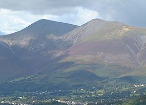
Skiddaw is a mountain in the Lake District National Park in England. With a summit at 931 m above sea level it is the fourth highest mountain in England. It lies just north of the town of Keswick, Cumbria, and dominates the skyline in this part of the northern lakes...
, they occupy a wide area to the north of Keswick
Keswick, Cumbria
Keswick is a market town and civil parish within the Borough of Allerdale in Cumbria, England. It had a population of 4,984, according to the 2001 census, and is situated just north of Derwent Water, and a short distance from Bassenthwaite Lake, both in the Lake District National Park...
. Smooth sweeping slopes predominate with a minimum of tarns
Tarn (lake)
A tarn is a mountain lake or pool, formed in a cirque excavated by a glacier. A moraine may form a natural dam below a tarn. A corrie may be called a cirque.The word is derived from the Old Norse word tjörn meaning pond...
or crag
Cliff
In geography and geology, a cliff is a significant vertical, or near vertical, rock exposure. Cliffs are formed as erosion landforms due to the processes of erosion and weathering that produce them. Cliffs are common on coasts, in mountainous areas, escarpments and along rivers. Cliffs are usually...
s. Blencathra
Blencathra
Blencathra, also known as Saddleback, is one of the most northerly mountains in the English Lake District. It has six separate fell tops, of which the highest is the Hallsfell Top.-Name:...
in the south east of the group is the principal exception to this trend.
Partition of the Lakeland Fells
National park
A national park is a reserve of natural, semi-natural, or developed land that a sovereign state declares or owns. Although individual nations designate their own national parks differently A national park is a reserve of natural, semi-natural, or developed land that a sovereign state declares or...
in the north west of the country which, in addition to its lake
Lake
A lake is a body of relatively still fresh or salt water of considerable size, localized in a basin, that is surrounded by land. Lakes are inland and not part of the ocean and therefore are distinct from lagoons, and are larger and deeper than ponds. Lakes can be contrasted with rivers or streams,...
s, contains a complex range of hills. These are known locally as fells and range from low hills to the highest ground in England. Hundreds of tops exist and many writers have attempted to draw up definitive lists
Hill lists in the British Isles
The mountains and hills of Great Britain, and to a lesser extent Ireland, are the subject of a considerable number of lists that categorise them by height, topographic prominence, or other criteria. They are commonly used as a basis for peak bagging, whereby hillwalkers attempt to reach all the...
. In doing so the compilers frequently divide the range into smaller areas to aid their description.
The most influential of all such authors was Alfred Wainwright
Alfred Wainwright
Alfred Wainwright MBE was a British fellwalker, guidebook author and illustrator. His seven-volume Pictorial Guide to the Lakeland Fells, published between 1955 and 1966 and consisting entirely of reproductions of his manuscript, has become the standard reference work to 214 of the fells of the...
whose Pictorial Guide to the Lakeland Fells
Pictorial Guide to the Lakeland Fells
A Pictorial Guide to the Lakeland Fells is a series of seven books by A. Wainwright, detailing the fells of the Lake District in northwest England...
series has sold in excess of 2 million copies, being in print continuously since the first volume was published in 1952. Wainwright divided the fells into seven geographical areas, each surrounded by valleys and low passes. While any such division must be arbitrary- and later writers have deviated to a greater or lesser extent from this blueprint- Wainwright's sevenfold division remains the best known partitioning of the fells into 'sub ranges', each with its own characteristics. The Northern Fells are one of these divisions, covered by volume 5 of Wainwright's work..
Boundaries
Bassenthwaite Lake
Bassenthwaite Lake is one of the largest water bodies in the English Lake District. It is long and narrow, approximately long and wide, but is also extremely shallow, with a maximum depth of about ....
and the southern perimeter by the River Greta, one of its principal feeders. The River Caldew bounds the eastern edge of the group, flowing away toward Carlisle. At Caldbeck the Calder is joined by the Whelpo Beck which drains many of the northern slopes. Only on the east, between the headwaters of the Greta and Caldew, does a bridge of higher ground strike out to connect with the rest of Lakeland, a long ridge curving southward to connect with Great Mell Fell
Great Mell Fell
Great Mell Fell is a hill in the Eastern Fells of the English Lake District. It is a north-eastern outlier of the Helvellyn range, but, like its twin Little Mell Fell, is isolated from its fellows, standing in the middle of a flat plain...
in the Eastern Fells
Eastern Fells
The Eastern Fells are a group of hills in the English Lake District. Centred on Helvellyn they primarily comprise a north south ridge running between Ullswater and Lakeland's Central Valley.-Partition of the Lakeland Fells:...
. This ridge, whilst significant topographically, is in many places unnoticed on the ground. The deep trough of Bassenthwaite wards off the North Western Fells
North Western Fells
The North Western Fells are a group of hills in the English Lake District. Including such favourites as Catbells and Grisedale Pike, they occupy an oval area beneath the Buttermere and Borrowdale valley systems...
, while the Central Fells
Central Fells
The Central Fells are a group of hills in the English Lake District. Reaching their highest point at High Raise , they occupy a broad area to the east of Borrowdale. Perhaps unexpectedly the Central Fells are generally lower than the surrounding hills, the Lake District's general dome-like...
rise beyond Keswick and the Greta.
North of the area defined by Wainwright the countryside takes on a moorland character, gradually declining toward the Solway Firth
Solway Firth
The Solway Firth is a firth that forms part of the border between England and Scotland, between Cumbria and Dumfries and Galloway. It stretches from St Bees Head, just south of Whitehaven in Cumbria, to the Mull of Galloway, on the western end of Dumfries and Galloway. The Isle of Man is also very...
. Some of the minor tops in this area were covered by Wainwright in his later Outlying Fells volume, published in 1974.
Topography
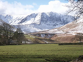
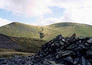
The Northern Fells occupy a circular area about 10 miles in diameter. The centre is slightly lower, an area of upland grazing and marshland known as Skiddaw Forest. This name may be misleading since the only trees form the windbreak of Skiddaw House. This isolated building, 3 miles from roads or other habitation, was once a shepherd's bothy. It currently serves as a youth hostel. Skiddaw Forest stands at the head of the three major rivers of the Northern Fells. The Caldew begins eastward, Dash Beck flows north west and the Glenderaterra to the south. These streams divide the circular area into three distinct sections.The highest ground is in the south west, between the Glenderaterra and Dash Beck. This is the Skiddaw
Skiddaw
Skiddaw is a mountain in the Lake District National Park in England. With a summit at 931 m above sea level it is the fourth highest mountain in England. It lies just north of the town of Keswick, Cumbria, and dominates the skyline in this part of the northern lakes...
group, well known in views down Borrowdale
Borrowdale
Borrowdale is a valley and civil parish in the English Lake District in the Borough of Allerdale in Cumbria, England.Borrowdale lies within the historic county boundaries of Cumberland, and is sometimes referred to as Cumberland Borrowdale in order to distinguish it from another Borrowdale in the...
and Derwentwater. The steep but sweeping slopes, deep folds and smooth texture can best be described as resembling a heavy sheet of velvet laid over a supporting frame. Skiddaw stands in the centre of the group, surrounded by its many satellites. Above Bassenthwaite are Ullock Pike
Ullock Pike
Ullock Pike is a fell situated in northern part of the English Lake District. It is located seven kilometres north west of Keswick and achieves a height of 692 metres...
, Long Side
Long Side
Long Side is a fell in the English Lake District, it is situated six kilometres north west of Keswick in the northern sector of the national park and is part of the Skiddaw group of fells. Long Side which reaches a height of 734 m is located on Skiddaw’s north western ridge, the middle...
, Carl Side
Carl Side
Carl Side is a fell in the English Lake District, forming a part of the Skiddaw "family" near the town of Keswick and prominently visible from its streets...
and the sometimes wooded Dodd
Dodd (Lake District)
Dodd is a small fell in the Lake District, Cumbria, England, four kilometres north-west of Keswick. It forms part of the Skiddaw range in the northern part of the national park and the slopes are heavily wooded.-Forestry:...
. Eastward are Skiddaw Little Man
Skiddaw Little Man
Skiddaw Little Man also called Little Man is a fell in the English Lake District, it is situated four kilometres north of the town of Keswick and reaches a height of 865 m .-Topography:...
, Lonscale Fell
Lonscale Fell
Lonscale Fell is a hill in the English Lake District. Its pointed second top is instantly recognisable, standing at the eastern end of the Skiddaw massif. The fell is easily climbed from Keswick or from Skiddaw House to the north...
and the diminutive Latrigg
Latrigg
Latrigg is one of the lowest fells in the Lake District, but is a popular climb due to its convenient location overlooking the town of Keswick and the beautiful views down the valley of Borrowdale from the summit. It is the least mountainous of the Skiddaw fells, the summit being almost entirely...
, a pleasant short climb from Keswick.
Blencathra
Blencathra, also known as Saddleback, is one of the most northerly mountains in the English Lake District. It has six separate fell tops, of which the highest is the Hallsfell Top.-Name:...
with its blasted crags and knife-edge ridges overlooking the Keswick to Penrith road. The northern ridges lead to Souther Fell
Souther Fell
Souther Fell is a fell in the English Lake District. It stands to the south of Mungrisdale village in the Northern Fells. It is most famous for the appearance of a "spectral army", said to have been seen marching along its crest on Midsummer's Day, 1745...
(of 'Spectral Army' fame), Bannerdale Crags
Bannerdale Crags
Bannerdale Crags is a fell in the English Lake District. It stands between Blencathra and Bowscale Fell in the Northern Fells.-Topography:Bannerdale Crags is a ridge running north west to south east...
, Bowscale Fell
Bowscale Fell
Bowscale Fell is a hill in the English Lake District. It rises above the village of Mungrisdale in the Northern Fells. Bowscale Fell stands at the extreme north east the Blencathra group, connected to this higher fell by the intervening Bannerdale Crags...
and Mungrisdale Common
Mungrisdale Common
Mungrisdale Common, pronounced mun-grize-dl, with emphasis on grize, is a fell in the English Lake District. Although Alfred Wainwright listed it as one of the 214 featured hills in his influential Pictorial Guide to the Lakeland Fells it was his least favourite. He commented that it "has no more...
, the most inexplicable of Wainwight's choice of fells with a barely discernible summit.
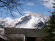
The northern section is known commonly as 'Back o'Skiddaw' and contains many lower fells of a gentler nature, although the paths to climb them can be long. In these hills are many evidences of historic mining activity, a testament to the mineral wealth beneath. The group has a central apex at Knott
Knott
Knott is a mountain in the northern part of the English Lake District. It is the highest point of the Back o'Skiddaw region, an area of wild and unfrequented moorland to the north of Skiddaw and Blencathra. Other tops in this region include High Pike, Carrock Fell and Great Calva. The fell's slopes...
with Great Calva
Great Calva
Great Calva is a fell in the Lake District, England. It is in the Northern Fells, lying roughly at the centre of this region of high ground. As a result it is distant from roads and quite remote by Lakeland standards...
standing to the south above Skiddaw Forest. High Pike (Caldbeck)
High Pike (Caldbeck)
High Pike is a fell in the northern part of the English Lake District, it is located 4.5 kilometres south of Caldbeck. It has a height of 658 metres and is the most northerly of the Lakeland fells over 2000 feet. It is a large fell with its northern slopes falling away towards the lower ground...
and Carrock Fell
Carrock Fell
Carrock Fell is a fell in the English Lake District, situated in the northern region of the national park 13 kilometres north east of Keswick. The fell's name means "Rocky Fell" and comes from a combination of the Old Welsh language with the word "carrec" meaning rock and the Old Norse language...
rise to the east, marching along the Caldew valley. The western ridges are more complex and include Great Sca Fell
Great Sca Fell
Great Sca Fell is a fell in the English Lake District, it stands seven kilometres southwest of the village of Caldbeck and is the highest of the four Uldale Fells .-Topography:...
, Meal Fell
Meal Fell
Meal Fell is a small fell in the northern region of the English Lake District, it is situated seven kilometres south west of the village of Caldbeck and is one of the four main Uldale Fells ....
, Great Cockup
Great Cockup
Great Cockup is a fell in the northern region of the English Lake District, one of the four Uldale Fells .- Description :...
, Brae Fell
Brae Fell
Brae Fell is a fell in the English Lake District, situated 12 kilometres north of Keswick it reaches a height of 586 m and is regarded as part of the Caldbeck Fells along with High Pike and Carrock Fell even though it has ridge links to the Uldale Fells. The fell's name has Scottish overtones...
and Longlands Fell
Longlands Fell
Longlands Fell is a small fell in the northern part of the English Lake District. It is situated in the high ground known as the Uldale Fells, 5.5 kilometres south west of the village of Caldbeck...
. Alone to the extreme west across the tarn of Over Water
Over Water
Over Water is a small lake or tarn in the north of the English Lake District near the village of Longlands. Although only a fifteen-minute drive from Keswick it is quieter than many of the better-known lakes. Binsey, Great Cockup and Longlands Fell overlook the lake.Over Water was a small natural...
stands Binsey
Binsey
Binsey is a hill on the northern edge of the Lake District in Cumbria, England. It is detached from the rest of the Lakeland hills, and thus provides a good spot to look out at the Northern and North Western Fells of the Lake District, as well as the coastal plain and, across the Solway Firth,...
.
Access for walkers
A66 road
The A66 is a major road in northern England which in part follows the course of the Roman road from Scotch Corner to Penrith. It runs from east of Middlesbrough in the ceremonial county of North Yorkshire to Workington in Cumbria...
for the Skiddaw and Blencathra groups respectively. The minor road along the eastern boundary connects the hamlets of Mosedale and Mungrisdale and gives equally good access to the Caldew and other eastern valleys. Further minor roads circuit the northern perimeter for operations Back o'Skiddaw, connecting finally to the Keswick - Carlisle road along the shore of Bassenthwaite. From here the Dash Valley and Longside Edge can be gained. A service track follows Dash Beck past its major fall (Whitewater Dash) to Skiddaw House, the easiest entrance to Skiddaw Forest.
The tourist route up Skiddaw will generally be busy, but solitude can easily be found on the northern hills.
See also
- Eastern FellsEastern FellsThe Eastern Fells are a group of hills in the English Lake District. Centred on Helvellyn they primarily comprise a north south ridge running between Ullswater and Lakeland's Central Valley.-Partition of the Lakeland Fells:...
- Far Eastern FellsFar Eastern FellsThe Far Eastern Fells are a group of hills in the English Lake District. Reaching their highest point at High Street they occupy a broad area to the east of Ullswater and Kirkstone Pass. Much quieter than the central areas of Lakeland they offer in general easier but less exciting walking as the...
- Central FellsCentral FellsThe Central Fells are a group of hills in the English Lake District. Reaching their highest point at High Raise , they occupy a broad area to the east of Borrowdale. Perhaps unexpectedly the Central Fells are generally lower than the surrounding hills, the Lake District's general dome-like...
- Southern FellsSouthern FellsImage:Annotated Scafell range.jpg|thumb|300px|The Scafellsrect 23 372 252 419 Slight Side rect 173 794 560 834 Scafell East Buttressrect 707 787 893 861 Esk Pike or Crag rect 245 303 409 358 Sca Fell rect 408 238 637 280 Mickledore Image:Annotated Scafell range.jpg|thumb|300px|The Scafellsrect 23...
- North Western FellsNorth Western FellsThe North Western Fells are a group of hills in the English Lake District. Including such favourites as Catbells and Grisedale Pike, they occupy an oval area beneath the Buttermere and Borrowdale valley systems...
- Western FellsWestern FellsThe Western Fells are a group of hills in the English Lake District. Centred on Great Gable they occupy a triangular area between Buttermere and Wasdale...