
Souther Fell
Encyclopedia
Fell
“Fell” is a word used to refer to mountains, or certain types of mountainous landscape, in Scandinavia, the Isle of Man, and parts of northern England.- Etymology :...
in the English
England
England is a country that is part of the United Kingdom. It shares land borders with Scotland to the north and Wales to the west; the Irish Sea is to the north west, the Celtic Sea to the south west, with the North Sea to the east and the English Channel to the south separating it from continental...
Lake District
Lake District
The Lake District, also commonly known as The Lakes or Lakeland, is a mountainous region in North West England. A popular holiday destination, it is famous not only for its lakes and its mountains but also for its associations with the early 19th century poetry and writings of William Wordsworth...
. It stands to the south of Mungrisdale
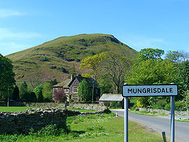
Mungrisdale
Mungrisdale is a small village and civil parish in the north east of the English Lake District in Cumbria. It is also the name of the valley in which the village sits....
village in the Northern Fells
Northern Fells
The Northern Fells are a group of hills in the English Lake District. Including Skiddaw, they occupy a wide area to the north of Keswick. Smooth sweeping slopes predominate with a minimum of tarns or crags...
. It is most famous for the appearance of a "spectral army", said to have been seen marching along its crest on Midsummer's Day, 1745. No such force was in the District at the time.
Topography
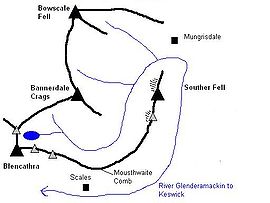
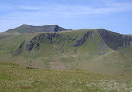
Souther Fell is the eastern extremity of BlencathraBlencathra
Blencathra, also known as Saddleback, is one of the most northerly mountains in the English Lake District. It has six separate fell tops, of which the highest is the Hallsfell Top.-Name:...
, a continuation of the arm which runs down from the summit over Doddick Fell and Scales Fell. A smooth slope falls eastward from Scales Fell to the col
Mountain pass
A mountain pass is a route through a mountain range or over a ridge. If following the lowest possible route, a pass is locally the highest point on that route...
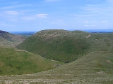
of Mousthwaite Comb at 1,425 ft. The ridge then turns northeast for two miles along the summit of Souther Fell.
Mousthwaite Comb is a geographical oddity. To the north of the depression, running eastward, is the River Glenderamackin. To the south of the col, flowing westward is the same river. In the intervening time the Glenderamackin has run for six miles, surrounding Souther Fell on three sides like a moat. The Comb provides its only dryshod connection to other ground and even this is almost cut off by the tributary of Comb beck on the southern slope.
The far northern end of the ridge falls quite steeply to a bend of the Glenderamackin, across which is the village of Mungrisdale. The eastern flanks are quite smooth and towards the south have been enclosed to provide pasture land. Southernfell, Far Southernfell and Hazelhurst are the farms here. At the southern end, on the turn of the ridge, is the rockier slope of Knotts, falling toward the main Keswick
Keswick, Cumbria
Keswick is a market town and civil parish within the Borough of Allerdale in Cumbria, England. It had a population of 4,984, according to the 2001 census, and is situated just north of Derwent Water, and a short distance from Bassenthwaite Lake, both in the Lake District National Park...
to Penrith
Penrith, Cumbria
Penrith was an urban district between 1894 and 1974, when it was merged into Eden District.The authority's area was coterminous with the civil parish of Penrith although when the council was abolished Penrith became an unparished area....
road.
The western side of the fell stands above the enclosed valley of the Upper Glenderamackin, looking across to Bannerdale Crags
Bannerdale Crags
Bannerdale Crags is a fell in the English Lake District. It stands between Blencathra and Bowscale Fell in the Northern Fells.-Topography:Bannerdale Crags is a ridge running north west to south east...
. Souther Fell has two principal tops and each stands above a patch of scree and rock on this face. A footbridge crosses the river just north of Mousthwaite Comb, the only reliable crossing between here and Mungrisdale village.
Geology
In common with much of the Northern Fells, the Kirk Stile Formation of the Skiddaw Group predominates. This is composed of laminated mudstoneMudstone
Mudstone is a fine grained sedimentary rock whose original constituents were clays or muds. Grain size is up to 0.0625 mm with individual grains too small to be distinguished without a microscope. With increased pressure over time the platey clay minerals may become aligned, with the...
and siltstone
Siltstone
Siltstone is a sedimentary rock which has a grain size in the silt range, finer than sandstone and coarser than claystones.- Description :As its name implies, it is primarily composed of silt sized particles, defined as grains 1/16 - 1/256 mm or 4 to 8 on the Krumbein phi scale...
with greywacke
Greywacke
Greywacke or Graywacke is a variety of sandstone generally characterized by its hardness, dark color, and poorly sorted angular grains of quartz, feldspar, and small rock fragments or lithic fragments set in a compact, clay-fine matrix. It is a texturally immature sedimentary rock generally found...
sandstone and is of Ordovician
Ordovician
The Ordovician is a geologic period and system, the second of six of the Paleozoic Era, and covers the time between 488.3±1.7 to 443.7±1.5 million years ago . It follows the Cambrian Period and is followed by the Silurian Period...
age.
The 'Spectral Army' of Souther Fell
On the evening of Midsummers Day 1745, a line of marching troops, cavalry and even carriages was seen travelling along the summit ridge of Souther Fell. The ground over which they appeared to move was known to be too steep for such transport, but the procession continued unabated for some hours until night fell, constantly appearing at one end of the ridge and disappearing at the other.26 sober and respected witnesses were assembled to view the proceedings and later testified on oath to what they had seen. The next day Souther Fell was climbed and not a footprint was found on the soft ground of the ridge.
The only scientific explanation ever offered was that this was some bizarre mirage or reflection of the army of Bonnie Prince Charlie, that day exercising on the Scottish coast.
Summit and view
Souther Fell has two main tops, although a number of other bumps crown the ridge. That to the north east is the true summit, the southern top being perhaps 30 ft lower. A small cairnCairn
Cairn is a term used mainly in the English-speaking world for a man-made pile of stones. It comes from the or . Cairns are found all over the world in uplands, on moorland, on mountaintops, near waterways and on sea cliffs, and also in barren desert and tundra areas...
marks the top.
This being the last of the Northern Fells in that direction, the view across to the Pennines
Pennines
The Pennines are a low-rising mountain range, separating the North West of England from Yorkshire and the North East.Often described as the "backbone of England", they form a more-or-less continuous range stretching from the Peak District in Derbyshire, around the northern and eastern edges of...
is uninterrupted. The Lakeland view peeps around the looming presence of Blencathra, taking in Great Gable
Great Gable
Great Gable is a mountain lying at the very heart of the English Lake District, appearing as a pyramid from Wasdale , but as a dome from most other directions. It is one of the most popular of the Lakeland fells, and there are many different routes to the summit...
, the Scafells
Scafells
Image:Annotated Scafell range.jpg|thumb|right|300px|The Scafell range as seen looking west from Crinkle Crags. rect 23 372 252 419 Slight Side rect 173 794 560 834 Scafell East Buttress...
, the nearer Helvellyn range
Helvellyn range
Helvellyn range is the name given to a part of the Eastern Fells in the English Lake District, fell being the local word for hill. The name comes from Helvellyn, the highest point of the group....
and a portion of the Far Eastern Fells
Far Eastern Fells
The Far Eastern Fells are a group of hills in the English Lake District. Reaching their highest point at High Street they occupy a broad area to the east of Ullswater and Kirkstone Pass. Much quieter than the central areas of Lakeland they offer in general easier but less exciting walking as the...
.