

Western Fells
Encyclopedia
England
England is a country that is part of the United Kingdom. It shares land borders with Scotland to the north and Wales to the west; the Irish Sea is to the north west, the Celtic Sea to the south west, with the North Sea to the east and the English Channel to the south separating it from continental...
Lake District
Lake District
The Lake District, also commonly known as The Lakes or Lakeland, is a mountainous region in North West England. A popular holiday destination, it is famous not only for its lakes and its mountains but also for its associations with the early 19th century poetry and writings of William Wordsworth...
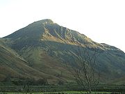
. Centred on Great Gable
Great Gable
Great Gable is a mountain lying at the very heart of the English Lake District, appearing as a pyramid from Wasdale , but as a dome from most other directions. It is one of the most popular of the Lakeland fells, and there are many different routes to the summit...
they occupy a triangular area between Buttermere
Buttermere
Buttermere is a lake in the English Lake District in North West England. The adjacent village of Buttermere takes its name from the lake. Historically within the former county of Cumberland, the lake is now within the county of Cumbria. It is owned by the National Trust, forming part of their...
and Wasdale
Wasdale
Wasdale is a valley and civil parish in the western part of the Lake District National Park in Cumbria, England. The River Irt flows through the valley to its estuary at Ravenglass. A large part of the main valley floor is occupied by Wastwater, the deepest lake in England...
. The Western Fells are characterised by high ridges and an abundance of naked rock.
Partition of the Lakeland Fells
National park
A national park is a reserve of natural, semi-natural, or developed land that a sovereign state declares or owns. Although individual nations designate their own national parks differently A national park is a reserve of natural, semi-natural, or developed land that a sovereign state declares or...
in the north west of the country which, in addition to its lake
Lake
A lake is a body of relatively still fresh or salt water of considerable size, localized in a basin, that is surrounded by land. Lakes are inland and not part of the ocean and therefore are distinct from lagoons, and are larger and deeper than ponds. Lakes can be contrasted with rivers or streams,...
s, contains a complex range of hills. These are known locally as fells and range from low hills to the highest ground in England. Hundreds of tops exist and many writers have attempted to draw up definitive lists
Hill lists in the British Isles
The mountains and hills of Great Britain, and to a lesser extent Ireland, are the subject of a considerable number of lists that categorise them by height, topographic prominence, or other criteria. They are commonly used as a basis for peak bagging, whereby hillwalkers attempt to reach all the...
. In doing so the compilers frequently divide the range into smaller areas to aid their description.
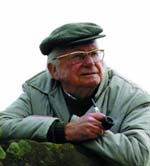
The most influential of all such authors was Alfred Wainwright
Alfred Wainwright
Alfred Wainwright MBE was a British fellwalker, guidebook author and illustrator. His seven-volume Pictorial Guide to the Lakeland Fells, published between 1955 and 1966 and consisting entirely of reproductions of his manuscript, has become the standard reference work to 214 of the fells of the...
whose Pictorial Guide to the Lakeland Fells
Pictorial Guide to the Lakeland Fells
A Pictorial Guide to the Lakeland Fells is a series of seven books by A. Wainwright, detailing the fells of the Lake District in northwest England...
series has sold in excess of 2 million copies, being in print continuously since the first volume was published in 1952. Wainwright divided the fells into seven geographical areas, each surrounded by valleys and low passes. While any such division must be arbitrary-and later writers have deviated to a greater or lesser extent from this blueprint- Wainwright's sevenfold division remains the best known partitioning of the fells into 'sub ranges', each with its own characteristics. The Western Fells are one of these divisions, covered by volume 7 of Wainwright's work.
Boundaries
.jpg)
Borrowdale
Borrowdale is a valley and civil parish in the English Lake District in the Borough of Allerdale in Cumbria, England.Borrowdale lies within the historic county boundaries of Cumberland, and is sometimes referred to as Cumberland Borrowdale in order to distinguish it from another Borrowdale in the...
, closing the gap between Honister Pass
Honister Pass
The Honister Pass, also known as Honister Hause, is a mountain pass in the English Lake District. It is located on the B5289 road, linking Seatoller, in the valley of Borrowdale, to Gatesgarth at the southern end of Buttermere...
and Sty Head. Honister connects to the North Western Fells
North Western Fells
The North Western Fells are a group of hills in the English Lake District. Including such favourites as Catbells and Grisedale Pike, they occupy an oval area beneath the Buttermere and Borrowdale valley systems...
and Sty Head to the Southern
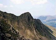
Southern Fells
Image:Annotated Scafell range.jpg|thumb|300px|The Scafellsrect 23 372 252 419 Slight Side rect 173 794 560 834 Scafell East Buttressrect 707 787 893 861 Esk Pike or Crag rect 245 303 409 358 Sca Fell rect 408 238 637 280 Mickledore Image:Annotated Scafell range.jpg|thumb|300px|The Scafellsrect 23...
.
Topography

Ennerdale
Ennerdale may refer to:* Ennerdale, Gauteng, a suburb of Johannesburg, South Africa* Ennerdale Water, a lake in the Lake District in England**Ennerdale Bridge, a nearby settlement...
so that in effect the group is the shape of a single horseshoe
Horseshoe
A horseshoe, is a fabricated product, normally made of metal, although sometimes made partially or wholly of modern synthetic materials, designed to protect a horse's hoof from wear and tear. Shoes are attached on the palmar surface of the hooves, usually nailed through the insensitive hoof wall...
, each branch about 10 miles in length.
At the head of Ennerdale stands Great Gable
Great Gable
Great Gable is a mountain lying at the very heart of the English Lake District, appearing as a pyramid from Wasdale , but as a dome from most other directions. It is one of the most popular of the Lakeland fells, and there are many different routes to the summit...
, the highest of the Western Fells at 2,949 ft. More commonly thought of as a Wasdale Fell, its profile from that valley gives it its name. The southern arc of the group travels due west from Great Gable, the main ridge consisting of Kirk Fell
Kirk Fell
Kirk Fell is a fell in the Western part of the English Lake District. It is situated between Great Gable and Pillar on the long ring of fells surrounding the valley of Ennerdale, and also stands over Wasdale to the south...
, Pillar
Pillar (Lake District)
Pillar is a mountain in the western part of the English Lake District. Situated between the valleys of Ennerdale to the north and Wasdale to the south, it is the highest point of the Pillar group . At 892 metres it is the eighth highest mountain in the Lake District...
(named for its great out-thrust of rock), Scoat Fell
Scoat Fell
Scoat Fell is a fell in the western part of the English Lake District. It stands at the head of the Mosedale Horseshoe with its back to Ennerdale...
, Haycock and Caw Fell
Caw Fell
Caw Fell is a fell in the English Lake District, standing between Haycock the Lank Rigg group. It occupies a wide upland area with Ennerdale to the north and Blengdale to the south...
. A number of outliers line the side valleys of Wasdale, namely Yewbarrow
Yewbarrow
Yewbarrow is a fell in the English Lake District which lies immediately north of the head of Wast Water. It is 628 metres high and in shape resembles the upturned hull of a boat or a barrow. Yewbarrow is on the left in the classic view of Great Gable and Wast Water.The top of Stirrup Crag...
, Red Pike (Wasdale)
Red Pike (Wasdale)
Red Pike is a fell in the English Lake District. It is 826 m or high and lies due north of Wast Water. It is often climbed as part of the Mosedale Horseshoe, a walk which also includes Pillar....
, Seatallan
Seatallan
Seatallan is a mountain in the western part of the English Lake District. It is rounded, grassy and fairly unassuming, occupying a large amount of land. However, it is classed as a Marilyn because of the low elevation of the col connecting it to Haycock, its nearest higher neighbour to the north...
, Middle Fell
Middle Fell
Middle Fell is a hill or fell in the English Lake District. It is a satellite of Seatallan standing above the northern shore of Wastwater. Middle Fell can be climbed from Greendale near the foot of Wastwater, and a fine view of the lake backed by the Wastwater Screes is visible from the...
and Buckbarrow
Buckbarrow
Buckbarrow is a small fell in the English Lake District situated at the western end of Wast Water. It is featured in Alfred Wainwright’s Pictorial Guide to the Lakeland Fells and is given a height of 1,410 ft approximately; however, the Ordnance Survey and other guide books now give an...
. Beyond Caw Fell is the lower Lank Rigg group, consisting of Lank Rigg
Lank Rigg
Lank Rigg is a fell in the English Lake District. It stands to the south of Ennerdale in the Western Fells. A sprawling hill with gentle grassy slopes it can be climbed from various points on the Coldfell road...
, Crag Fell
Crag Fell
Crag Fell is a hill in the English Lake District. It is part of the Lank Rigg group, standing above Ennerdale Water in the Western Fells. The craggy northern face above the lake gives the fell its name, prominent in views from the car park at Bowness Knott...
and Grike
Grike (Lake District)
Grike is a hill in the west of the English Lake District, near Ennerdale Water. It is part of the Lank Rigg group, the most westerly Wainwright as the fells diminish toward the coastal plain...
.
The northern arc begins with Great Gable's lesser sibling, Green Gable
Green Gable
Green Gable is a fell in the English Lake District often traversed by walkers on route to its more famous neighbour Great Gable. It can be ascended from Honister Pass, Seathwaite in Borrowdale, or Ennerdale...
, and Brandreth
Brandreth
Brandreth is a fell in the English Lake District. It stands between Great Gable and Haystacks in the Western Fells.-Topography:The Western Fells occupy a triangular sector of the Lake District, bordered by the River Cocker to the north east and Wasdale to the south east. Westwards the hills...
, before turning north west above the shore of Buttermere. First comes Haystacks, Wainwright's favourite fell and the resting place of his ashes. Next are High Crag
High Crag
High Crag stands at the southern end of the High Stile ridge which divides the valleys of Ennerdale and Buttermere in the west of the English Lake District. It is often climbed as part of a popular ridge walk, from Black Sail youth hostel, or from Buttermere via Scarth Gap...
, High Stile
High Stile
High Stile is a mountain in the western part of the Lake District in northwest England. It is the eleventh highest English Marilyn, standing 807 metres high, and has a relative height of 362 metres ....
and Red Pike (Buttermere)
Red Pike (Buttermere)
Red Pike is a fell in the High Stile range in the western English Lake District, which separates Ennerdale from the valley of Buttermere and Crummock Water. It is high...
, the three fells of Buttermere Edge. These are connected by narrow soaring ridges and shelter dark coombes from the sunlight. The wild and rocky character of the range then gradually diminishes with Starling Dodd
Starling Dodd
Starling Dodd is a fell in the western part of the English Lake District, located between the valleys of Ennerdale and Buttermere, on the ridge between Great Borne to its west and Red Pike to its east...
and Great Borne
Great Borne
Great Borne is a fell in the English Lake District with a height of . It is a rather secluded hill situated at the western end of the long ridge which divides the Ennerdale and Buttermere valleys.-Name:...
, before crossing the pedestrian Floutern Pass to the Loweswater Fells. These are Mellbreak
Mellbreak
Mellbreak is a hill in the Western part of the English Lake District. Despite being surrounded on all sides by higher fells , it stands in isolation. It is surrounded on three sides by a 'moat' of deep marshy land, and on the east side by the lake of Crummock Water...
, brooding darkly above Crummock Water
Crummock Water
Crummock Water is a lake in the Lake District in Cumbria, North West England situated between Buttermere to the south and Loweswater to the north. Crummock Water is two and a half miles long, three quarters of a mile wide and 140ft deep. The River Cocker is considered to start at the north of the...
, Hen Comb
Hen Comb
Hen Comb is a fell in the west of the English Lake District. One of the Loweswater Fells it lies to the south of Loweswater lake and Loweswater village...
, Gavel Fell
Gavel Fell
Gavel Fell is a hill in the English Lake District. Centremost of the five Loweswater Fells in the western part of the District, it stands between Hen Comb and Blake Fell...
, Blake Fell
Blake Fell
Blake Fell is a hill in the Western part of the English Lake District. It is the highest point of the Loweswater Fells, an area of low grassy hills with steep sides overlooking the lake of Loweswater. The fell also overlooks the village of Loweswater, from which it can be climbed. An alternative...
and Burnbank Fell
Burnbank Fell
Burnbank Fell is a small hill in the west of the English Lake District. It is the most westerly of the Loweswater Fells, a group of low grassy hills lying just south of Loweswater. The hill is predominantly grassy with sprawling flanks and a broad ridge connecting it to Blake Fell...
. The final extremity of the northern arc curves around the head of Loweswater
Loweswater
Loweswater is one of the smaller lakes in the English Lake District. The village of Loweswater is situated at the foot of the lake.The lake is not far from Cockermouth and is also easily reached from elsewhere in West Cumbria. The group of fells to the south of Loweswater is known as the Loweswater...
to Low Fell and Fellbarrow
Fellbarrow
Fellbarrow is a low hill in the north west of the English Lake District. It is not far from the town of Cockermouth, near to Loweswater and can most easily be climbed from Low Lorton, or Thackthwaite...
. The satellites of the main ridge, Base Brown
Base Brown
Base Brown is a fell in England's Lake District, near the head of the Borrowdale Valley. It forms one side of the Seathwaite Valley, and on the western side it is flanked by the hanging valley of Gillercomb.-Topography:...
, Grey Knotts
Grey Knotts
Grey Knotts is a fell in the English Lake District, it is situated one kilometre south of the B5289 road as it crosses the Honister Pass, it is well seen from mid Borrowdale as it rises above Seatoller...
and Fleetwith Pike
Fleetwith Pike
Fleetwith Pike is a fell in the English Lake District in the county of Cumbria which reaches a height of 648 metres . The fell is a well-known feature of the area as it casts an imposing presence over Buttermere and the Honister Pass on the B5289 motor road between Borrowdale and...
, centre upon Brandreth.
Access for walkers
See also
- Eastern FellsEastern FellsThe Eastern Fells are a group of hills in the English Lake District. Centred on Helvellyn they primarily comprise a north south ridge running between Ullswater and Lakeland's Central Valley.-Partition of the Lakeland Fells:...
- Far Eastern FellsFar Eastern FellsThe Far Eastern Fells are a group of hills in the English Lake District. Reaching their highest point at High Street they occupy a broad area to the east of Ullswater and Kirkstone Pass. Much quieter than the central areas of Lakeland they offer in general easier but less exciting walking as the...
- Central FellsCentral FellsThe Central Fells are a group of hills in the English Lake District. Reaching their highest point at High Raise , they occupy a broad area to the east of Borrowdale. Perhaps unexpectedly the Central Fells are generally lower than the surrounding hills, the Lake District's general dome-like...
- Southern FellsSouthern FellsImage:Annotated Scafell range.jpg|thumb|300px|The Scafellsrect 23 372 252 419 Slight Side rect 173 794 560 834 Scafell East Buttressrect 707 787 893 861 Esk Pike or Crag rect 245 303 409 358 Sca Fell rect 408 238 637 280 Mickledore Image:Annotated Scafell range.jpg|thumb|300px|The Scafellsrect 23...
- Northern FellsNorthern FellsThe Northern Fells are a group of hills in the English Lake District. Including Skiddaw, they occupy a wide area to the north of Keswick. Smooth sweeping slopes predominate with a minimum of tarns or crags...
- North Western FellsNorth Western FellsThe North Western Fells are a group of hills in the English Lake District. Including such favourites as Catbells and Grisedale Pike, they occupy an oval area beneath the Buttermere and Borrowdale valley systems...