
Mungrisdale Common
Encyclopedia
Fell
“Fell” is a word used to refer to mountains, or certain types of mountainous landscape, in Scandinavia, the Isle of Man, and parts of northern England.- Etymology :...
in the English
England
England is a country that is part of the United Kingdom. It shares land borders with Scotland to the north and Wales to the west; the Irish Sea is to the north west, the Celtic Sea to the south west, with the North Sea to the east and the English Channel to the south separating it from continental...
Lake District
Lake District
The Lake District, also commonly known as The Lakes or Lakeland, is a mountainous region in North West England. A popular holiday destination, it is famous not only for its lakes and its mountains but also for its associations with the early 19th century poetry and writings of William Wordsworth...
. Although Alfred Wainwright
Alfred Wainwright
Alfred Wainwright MBE was a British fellwalker, guidebook author and illustrator. His seven-volume Pictorial Guide to the Lakeland Fells, published between 1955 and 1966 and consisting entirely of reproductions of his manuscript, has become the standard reference work to 214 of the fells of the...
listed it as one of the 214 featured hills in his influential Pictorial Guide to the Lakeland Fells
Pictorial Guide to the Lakeland Fells
A Pictorial Guide to the Lakeland Fells is a series of seven books by A. Wainwright, detailing the fells of the Lake District in northwest England...
it was his least favourite. He commented that it "has no more pretension to elegance than a pudding that has been sat on". There is some speculation that Wainwright included the fell in his guide simply as a way to fill space, although this has never been proven. Mungrisdale Common is oddly named as it is a number of miles from Mungrisdale village
Mungrisdale
Mungrisdale is a small village and civil parish in the north east of the English Lake District in Cumbria. It is also the name of the valley in which the village sits....
, which lies in a different river catchment.
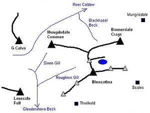
Topography
Mungrisdale Common lies north of BlencathraBlencathra
Blencathra, also known as Saddleback, is one of the most northerly mountains in the English Lake District. It has six separate fell tops, of which the highest is the Hallsfell Top.-Name:...
, of which it is an outlier. Gently graded grassy slopes fall from Atkinson Pike, Blencathra's northern summit. Upon meeting the head of Blackhazel Beck this shoulder divides in two, the north eastern arm connecting to Bannerdale Crags
Bannerdale Crags
Bannerdale Crags is a fell in the English Lake District. It stands between Blencathra and Bowscale Fell in the Northern Fells.-Topography:Bannerdale Crags is a ridge running north west to south east...
and the north western branch continuing to descend to Mungrisdale Common. Beyond an almost imperceptible depression the reascent is only 6 ft.
After the brief plateau of the summit the descent continues westward toward Skiddaw Forest. Confusingly this forest contains no trees—other than the windbreak of Skiddaw House — but is a marshy upland area at around 1,300 ft surrounded on all sides by higher fells. Three streams flow from Skiddaw Forest, dividing the Northern Fells into three sectors. Dash Beck runs north west, the River Caldew north east and the Glenderaterra Beck south. The three ranges of the Northern Fells are the Skiddaw
Skiddaw
Skiddaw is a mountain in the Lake District National Park in England. With a summit at 931 m above sea level it is the fourth highest mountain in England. It lies just north of the town of Keswick, Cumbria, and dominates the skyline in this part of the northern lakes...
massif to the south west, the Blencathra group— including Mungrisdale Common— to the south east and the area colloquially known as 'Back o'Skiddaw' to the north. Skiddaw House, the lone building in the forest, has variously seen service as a shepherds' bothy and a Youth Hostel.
The Glenderaterra Beck lies to the west of Mungrisdale Common and its tributary, Roughten Gill, forms the southern boundary. A further feeder on this flank is Sinen Gill, whose waterfall
Waterfall
A waterfall is a place where flowing water rapidly drops in elevation as it flows over a steep region or a cliff.-Formation:Waterfalls are commonly formed when a river is young. At these times the channel is often narrow and deep. When the river courses over resistant bedrock, erosion happens...
is one of the fell's most notable features. The River Caldew lies to the north, across which is Great Calva
Great Calva
Great Calva is a fell in the Lake District, England. It is in the Northern Fells, lying roughly at the centre of this region of high ground. As a result it is distant from roads and quite remote by Lakeland standards...
, most southerly of the Back o'Skiddaw fells. Despite its uninspiring appearance Mungrisdale Common does therefore stand on the important Eden
River Eden, Cumbria
The River Eden is a river that flows through Cumbria, England on its way to the Solway Firth.-Course of river:The Eden rises in Black Fell Moss, Mallerstang, on the high ground between High Seat, Yorkshire Dales and Hugh Seat. Here it forms the boundary between the counties of Cumbria and North...
-Derwent
River Derwent, Cumbria
The Derwent is a river in the Lake District of the county of Cumbria in the north of England. The name Derwent is derived from a Celtic word for "oak trees"....
watershed, though it is not well defined at this point. Water from the southern flanks reach the sea at Workington
Workington
Workington is a town, civil parish and port on the west coast of Cumbria, England, at the mouth of the River Derwent. Lying within the Borough of Allerdale, Workington is southwest of Carlisle, west of Cockermouth, and southwest of Maryport...
while rain falling on the northern side heads for the Solway Firth
Solway Firth
The Solway Firth is a firth that forms part of the border between England and Scotland, between Cumbria and Dumfries and Galloway. It stretches from St Bees Head, just south of Whitehaven in Cumbria, to the Mull of Galloway, on the western end of Dumfries and Galloway. The Isle of Man is also very...
via Carlisle. This watershed continues across Skiddaw Forest between the headwaters of the Caldew and Glenderaterra, linking onward to Lonscale Fell
Lonscale Fell
Lonscale Fell is a hill in the English Lake District. Its pointed second top is instantly recognisable, standing at the eastern end of the Skiddaw massif. The fell is easily climbed from Keswick or from Skiddaw House to the north...
in the Skiddaw range.
Mungrisdale Common carries a very small cairn
Cairn
Cairn is a term used mainly in the English-speaking world for a man-made pile of stones. It comes from the or . Cairns are found all over the world in uplands, on moorland, on mountaintops, near waterways and on sea cliffs, and also in barren desert and tundra areas...
at the approximate summit, only constructed since Wainwright first encouraged climbing of the fell by including it in his 1962 guidebook. Two more prominent ancient cairns also grace the fell, one to the west of the summit and the other on a tongue of ground between Sinen Gill and Roughten Gill. A small stone pillar (marked 'stake' on OS
Ordnance Survey
Ordnance Survey , an executive agency and non-ministerial government department of the Government of the United Kingdom, is the national mapping agency for Great Britain, producing maps of Great Britain , and one of the world's largest producers of maps.The name reflects its creation together with...
maps) stands on the watershed at the head of Glenderaterra Beck and a further prominent Cloven Stone marks its continuation higher up the slope. Both have served as boundary stones.
Geology and Mining
In common with much of the Northern FellsNorthern Fells
The Northern Fells are a group of hills in the English Lake District. Including Skiddaw, they occupy a wide area to the north of Keswick. Smooth sweeping slopes predominate with a minimum of tarns or crags...
the Kirk Stile Formation of the Skiddaw Group predominates. This is composed of laminated mudstone
Mudstone
Mudstone is a fine grained sedimentary rock whose original constituents were clays or muds. Grain size is up to 0.0625 mm with individual grains too small to be distinguished without a microscope. With increased pressure over time the platey clay minerals may become aligned, with the...
and siltstone
Siltstone
Siltstone is a sedimentary rock which has a grain size in the silt range, finer than sandstone and coarser than claystones.- Description :As its name implies, it is primarily composed of silt sized particles, defined as grains 1/16 - 1/256 mm or 4 to 8 on the Krumbein phi scale...
with greywacke
Greywacke
Greywacke or Graywacke is a variety of sandstone generally characterized by its hardness, dark color, and poorly sorted angular grains of quartz, feldspar, and small rock fragments or lithic fragments set in a compact, clay-fine matrix. It is a texturally immature sedimentary rock generally found...
sandstone and is of Ordovician
Ordovician
The Ordovician is a geologic period and system, the second of six of the Paleozoic Era, and covers the time between 488.3±1.7 to 443.7±1.5 million years ago . It follows the Cambrian Period and is followed by the Silurian Period...
age. Unusually however, this is overlain by considerable beds of peat
Peat
Peat is an accumulation of partially decayed vegetation matter or histosol. Peat forms in wetland bogs, moors, muskegs, pocosins, mires, and peat swamp forests. Peat is harvested as an important source of fuel in certain parts of the world...
in the vicinity of Mungrisdale Common.
The Glenderaterra valley was the scene of some mining activity in the nineteenth century. The northern workings were first named Glenderaterra Mine and later Brundholme Mine. These were driven primarily for lead
Lead
Lead is a main-group element in the carbon group with the symbol Pb and atomic number 82. Lead is a soft, malleable poor metal. It is also counted as one of the heavy metals. Metallic lead has a bluish-white color after being freshly cut, but it soon tarnishes to a dull grayish color when exposed...
, but also copper
Copper
Copper is a chemical element with the symbol Cu and atomic number 29. It is a ductile metal with very high thermal and electrical conductivity. Pure copper is soft and malleable; an exposed surface has a reddish-orange tarnish...
ore and baryte. The returns were never economic, the mine being abandoned in 1920. A little to the south was Blencathra Mine, worked unsuccessfully until about 1880.
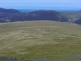
Summit and view
Wainwright's displeasure was not restricted to Mungrisdale Common's profile and he also remarked that "Any one of a thousand tufts of tough bent and cotton-grass might lay claim to crowning the highest point...A thousand tufts, yet not one can be comfortably reclined upon, this being a summit that holds indefinitely all the water that falls upon it"The view includes a striking window to the south west between Lonscale Fell and Blencathra, revealing unexpectedly a run of high fells from Pillar
Pillar (Lake District)
Pillar is a mountain in the western part of the English Lake District. Situated between the valleys of Ennerdale to the north and Wasdale to the south, it is the highest point of the Pillar group . At 892 metres it is the eighth highest mountain in the Lake District...
to Crinkle Crags
Crinkle Crags
Crinkle Crags is a fell in the English Lake District in the county of Cumbria. It forms part of two major rings of mountains, surrounding the valleys of Great Langdale and Upper Eskdale. The name reflects the fell's physical appearance as its summit ridge is a series of five rises and depressions ...
. Elsewhere the view consists of those nearby fells surrounding Skiddaw Forest.
Ascents
"for people who won't be told" Wainwright suggested ascents from Keswick or Threlkeld via the Glenderaterra valley. An alternative would be from Scales or Mungrisdale via the Glenderamackin col. Most ascents are likely to be as part of a climb of Blencathra, the intervening ground being gentle of gradient.Trivia
Apart from the sub 1,000 ft Castle CragCastle Crag
Castle Crag is a hill in the North Western Fells of the English Lake District. It is the smallest hill included in Alfred Wainwright's influential Pictorial Guide to the Lakeland Fells, the only Wainwright below 1,000 ft....
, Mungrisdale Common is the only Wainwright not to feature in Bill Birkett's Complete Lakeland Fells.