
Skiddaw
Encyclopedia
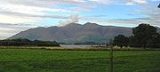
Skiddaw is a mountain
in the Lake District National Park
in England
. With a summit at 931 m (3,054 ft) above sea level it is the fourth highest mountain in England. It lies just north of the town of Keswick
, Cumbria
, and dominates the skyline in this part of the northern lakes. It is the simplest of the Lake District mountains of this height to ascend (as there is a well-trodden tourist track from a car park to the north-east of Keswick, near the summit of Latrigg
) and, as such, many walking guides recommend it to the occasional walker wishing to climb a mountain. This is the first summit of the fell running
challenge known as the Bob Graham Round
when undertaken in a clockwise direction.
The mountain lends its name to the surrounding areas of "Skiddaw Forest", and "Back o' Skidda'" and to the isolated "Skiddaw House", situated to the east, formerly a shooting lodge and subsequently a youth hostel. It also provides the name for the slate derived from that region: Skiddaw Slate
. Tuned percussion musical instruments or lithophone
s exist which are made from the slate, such as the Musical Stones of Skiddaw
held at Keswick Museum and Art Gallery
.
comprise a roughly circular upland area approaching 10 miles (16.1 km) in width. At the centre is the marshy depression of Skiddaw Forest— a treeless plateau at an altitude of 396 metres (1,299.2 ft); and flowing outwards from here are the rivers which divide the area into three sectors. The south-western sector, between the Glenderaterra Beck
and Dash Beck, contains Skiddaw and its satellites.
Skiddaw itself takes the form of a north-south ridge about half a mile long, with steep slopes to east and west. The ridge continues northwards over Broad End to Bakestall
, a fell overlooking the Whitewater Dash waterfall. Further ridges fan out east and west from the southern end of Skiddaw. To the south-east are Skiddaw Little Man
, Lonscale Fell
and Latrigg
, an easily accessible viewpoint for Keswick and Derwentwater. Beyond these fells are the Glenderaterra Beck
and the Blencathra
group. The south western ridge curves round through 180 degrees to run north above the shore of Bassenthwaite Lake
. This gives Skiddaw an 'outer wall', comprising Carl Side
, Long Side
and Ullock Pike
, collectively referred to as 'Longside Edge'. The final member of the Skiddaw Group is Dodd
, a satellite of Carl Side.
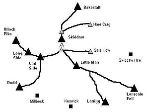 Between Skiddaw and Longside Edge are the quiet valleys of Southerndale and Barkbethdale, separated by the spur of Buzzard Knott. These drain the western flanks of the fell to Bassenthwaite Lake. The eastern side of Skiddaw drains into Skiddaw Forest, much of the water reaching Candleseaves Bog. This marsh is the source of both the Dash Beck flowing north west to Bassenthwaite and the River Caldew
, beginning its long journey north eastward to the Solway Firth
via Carlisle. Two smooth spurs on this eastern flank of Skiddaw, Sale How and Hare Crag, are listed in separate tops in some guidebooks. Sale How is also a Nuttall
Below Sale How is Skiddaw House, a stone building which has variously served as a shooting lodge, shepherd's bothy and Youth Hostel. Its windbreak comprises the only trees in Skiddaw Forest, and it is reached via a long access track up the Dash Valley
.
Skiddaw's slopes are generally rounded and convex, looking from a distance as though a thick velvet blanket has been draped over a supporting frame. On the ridges the general terrain is of loose stones, but elsewhere all is grass and heather. Wainwright
noted that "Its lines are smooth, its curves graceful; but because the slopes are steep everywhere, the quick build-up of the massif from valley levels to central summit is appreciated at a glance- and it should be an appreciative glance, for such massive strength and such beauty of outline rarely go together."
, is the Kirkstile Formation. This Ordovician
rock is composed of laminated mudstone
and siltstone
with greywacke
sandstone. At the summit this is overlain by scree
and to the south are areas where the underlying Loweswater Formation surfaces.
 The summit ridge bears a number of tops, which from north to south are known as North Top, High Man (the summit), Middle Top and South Top. All now bear cairn
s and a number of stone windshelters have been erected. Skiddaw has a subsidiary summit, Little Man
, which lies about 1.5 km south-south-east of the main peak. Despite its limited independence, Wainwright listed it as a separate fell in his influential Pictorial Guide to the Lakeland Fells
, a convention which is often followed.
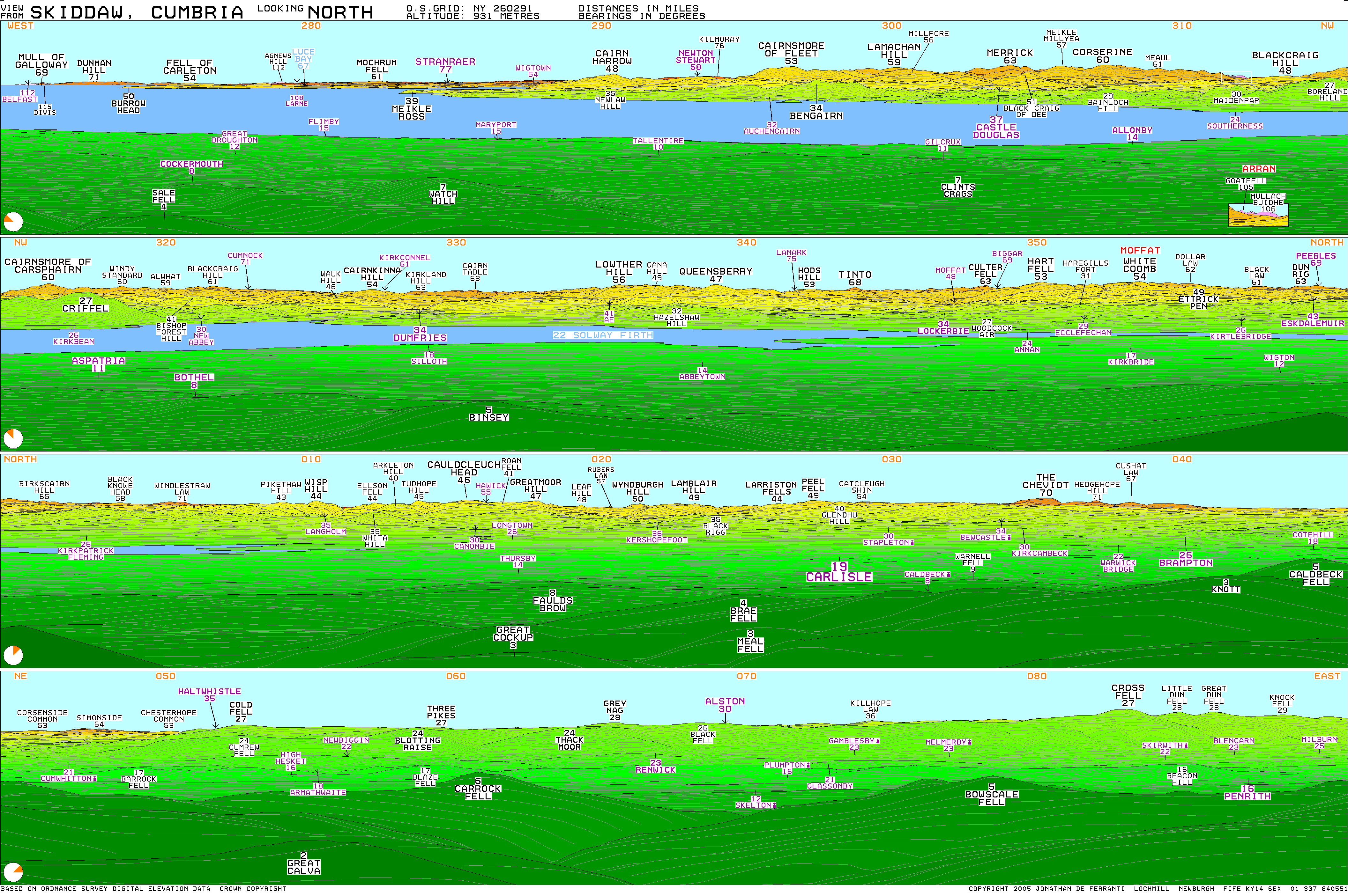
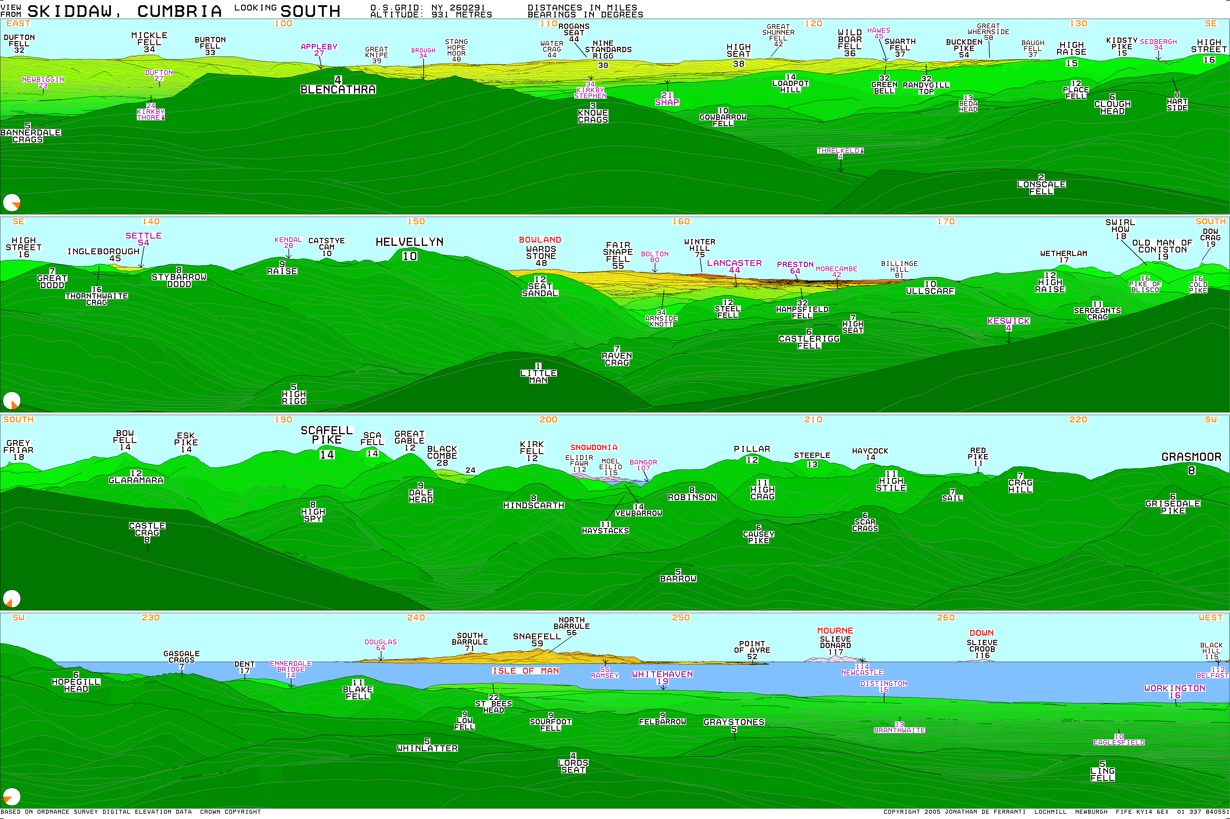
The view is as panoramic as might be expected, given Skiddaw's topographic prominence
. From High Man the north east quadrant is filled by the quiet fells of Back o'Skiddaw, with the Border hills, the Cheviots
and the North Pennines
behind them. To the south east are Blencathra, the Far Eastern Fells
and the Helvellyn range
; behind these are vistas of the Yorkshire Dales
and Forest of Bowland
. The Coniston Fells are visible directly to the south. On the other side of South Top is a fine view of the Scafells
, Western
and North Western Fells
, with a portion of Snowdonia
visible between Kirk Fell
and Pillar
. The Isle of Man
is visible 60 miles (96.6 km) away, as are the Mourne Mountains 120 miles (193.1 km) away (on exceptionally clear days). The final quarter is taken up by the coastal plain and the distant Solway Firth, backed by the hills of Galloway
such as Merrick
, Criffel
and Broad Law
. Goat Fell
on Arran
can be seen at an angle of 313 degrees, 105 miles (169 km) away.
Most distant view; Slieve Meelmore in Mourne
, 120 miles (193.1 km) distant.
Computer-generated panorama; north, south.
By moving to South Top a superb view of Borrowdale
can be brought into sight.
 Many routes of ascent have been devised for Skiddaw; indeed, it is hard to devise a challenging approach in good conditions. The most popular tourist route starts from Keswick and first ascends behind Latrigg, before the climb continues over the slopes of Little Man to the summit. About 200m of ascent can be saved by driving to the top of Gale Road and beginning from the public carpark just behind the summit of Latrigg.
Another popular route (and the one recommended by Wainwright) is to follow Longside Edge, first ascending Ullock Pike, Longside and Carl Side before making the steep climb up from Carlside Col. Also from the north, a somewhat tougher alternative is to walk up Buzzard Knott between Southerndale and Barkbethdale: after crossing to the southern edge of the shoulder above Randel Crag ascend due east to the summit. Rather easier than either of these is the compass-walk due south from Cock Up (505m); reversing this route provides a safe descent, especially in bad weather. Scramblers may prefer simply to walk up Southerndale and climb Longside via a distinctive crevice seen easily from Skiddaw summit.
From the south-west at Millbeck, Carlside Col can be reached directly. A start from nearby Applethwaite can also be used to provide a variation to the tourist route. From the north-west a tough but picturesque ascent can be made to the northern end of Longside Edge before following the ridge route to the summit. Finally, ascents from due east are possible for the walker who first makes for Skiddaw House, a good distance from either Keswick, Threlkeld
or Peter House. Once Skiddaw House is reached a fairly direct line is possible, climbing over either Sale How or Hare Crag.
From the north-east an unmarked but quite easy and fairly well-worn path starts at Whitewater Dash waterfall (on the Cumbrian Way
) where the walker can follow the fence (along Birkett Edge just south of Dead Crags) past the Bakestall outcrop, and follow the fence until just before the unnamed top at 831m. From the 831m top, a path leads directly to Skiddaw Man.
sgwïðow meaning "shoulders" (compare Welsh sgwyddau) from the shape of the mountain.
).
Mountain
Image:Himalaya_annotated.jpg|thumb|right|The Himalayan mountain range with Mount Everestrect 58 14 160 49 Chomo Lonzorect 200 28 335 52 Makalurect 378 24 566 45 Mount Everestrect 188 581 920 656 Tibetan Plateaurect 250 406 340 427 Rong River...
in the Lake District National Park
Lake District National Park
The Lake District National Park is located in the north-west of England and is the largest of the English National Parks and the second largest in the United Kingdom. It is in the central and most-visited part of the Lake District....
in England
England
England is a country that is part of the United Kingdom. It shares land borders with Scotland to the north and Wales to the west; the Irish Sea is to the north west, the Celtic Sea to the south west, with the North Sea to the east and the English Channel to the south separating it from continental...
. With a summit at 931 m (3,054 ft) above sea level it is the fourth highest mountain in England. It lies just north of the town of Keswick
Keswick, Cumbria
Keswick is a market town and civil parish within the Borough of Allerdale in Cumbria, England. It had a population of 4,984, according to the 2001 census, and is situated just north of Derwent Water, and a short distance from Bassenthwaite Lake, both in the Lake District National Park...
, Cumbria
Cumbria
Cumbria , is a non-metropolitan county in North West England. The county and Cumbria County Council, its local authority, came into existence in 1974 after the passage of the Local Government Act 1972. Cumbria's largest settlement and county town is Carlisle. It consists of six districts, and in...
, and dominates the skyline in this part of the northern lakes. It is the simplest of the Lake District mountains of this height to ascend (as there is a well-trodden tourist track from a car park to the north-east of Keswick, near the summit of Latrigg
Latrigg
Latrigg is one of the lowest fells in the Lake District, but is a popular climb due to its convenient location overlooking the town of Keswick and the beautiful views down the valley of Borrowdale from the summit. It is the least mountainous of the Skiddaw fells, the summit being almost entirely...
) and, as such, many walking guides recommend it to the occasional walker wishing to climb a mountain. This is the first summit of the fell running
Fell running
Fell running, also known as mountain running and hill running, is the sport of running and racing, off road, over upland country where the gradient climbed is a significant component of the difficulty...
challenge known as the Bob Graham Round
Bob Graham Round
The Bob Graham Round is a circuit of 42 fells in the English Lake District, including the peaks of Skiddaw, Helvellyn, Scafell and Scafell Pike...
when undertaken in a clockwise direction.
The mountain lends its name to the surrounding areas of "Skiddaw Forest", and "Back o' Skidda'" and to the isolated "Skiddaw House", situated to the east, formerly a shooting lodge and subsequently a youth hostel. It also provides the name for the slate derived from that region: Skiddaw Slate
Skiddaw Slate
Skiddaw slate is an early Ordovician metamorphosed sedimentary rock, as first identified on the slopes of Skiddaw in the English Lake District....
. Tuned percussion musical instruments or lithophone
Lithophone
A lithophone is a musical instrument consisting of a rock or pieces of rock which are struck to produce musical notes. Notes may be sounded in combination or in succession...
s exist which are made from the slate, such as the Musical Stones of Skiddaw
Musical Stones of Skiddaw
The Musical Stones of Skiddaw is a lithophone made of a type of hornfels rock found in Cumbria, England. Constructed between 1827 and 1840, the instrument has entertained royalty; it is now housed at the Keswick Museum and Art Gallery in Cumbria....
held at Keswick Museum and Art Gallery
Keswick Museum and Art Gallery
The Keswick Museum and Art Gallery in Cumbria was founded in 1873 and had a number of temporary homes as it grew, including the Moot Hall in Keswick town centre....
.
Topography
The Northern FellsNorthern Fells
The Northern Fells are a group of hills in the English Lake District. Including Skiddaw, they occupy a wide area to the north of Keswick. Smooth sweeping slopes predominate with a minimum of tarns or crags...
comprise a roughly circular upland area approaching 10 miles (16.1 km) in width. At the centre is the marshy depression of Skiddaw Forest— a treeless plateau at an altitude of 396 metres (1,299.2 ft); and flowing outwards from here are the rivers which divide the area into three sectors. The south-western sector, between the Glenderaterra Beck
Glenderaterra Beck
Glenderaterra Beck is a watercourse in the English county of Cumbria.The beck runs from its source on Burnt Horse through the valley between Lonscale Fell and Blencathra to its confluence with the River Greta at Brundholme near Threlkeld....
and Dash Beck, contains Skiddaw and its satellites.
Skiddaw itself takes the form of a north-south ridge about half a mile long, with steep slopes to east and west. The ridge continues northwards over Broad End to Bakestall
Bakestall
Bakestall is a fell in the English Lake District, it is situated seven kilometres north of Keswick in the quieter even secluded northern sector of the national park known as "Back o' Skiddaw".-Topography:...
, a fell overlooking the Whitewater Dash waterfall. Further ridges fan out east and west from the southern end of Skiddaw. To the south-east are Skiddaw Little Man
Skiddaw Little Man
Skiddaw Little Man also called Little Man is a fell in the English Lake District, it is situated four kilometres north of the town of Keswick and reaches a height of 865 m .-Topography:...
, Lonscale Fell
Lonscale Fell
Lonscale Fell is a hill in the English Lake District. Its pointed second top is instantly recognisable, standing at the eastern end of the Skiddaw massif. The fell is easily climbed from Keswick or from Skiddaw House to the north...
and Latrigg
Latrigg
Latrigg is one of the lowest fells in the Lake District, but is a popular climb due to its convenient location overlooking the town of Keswick and the beautiful views down the valley of Borrowdale from the summit. It is the least mountainous of the Skiddaw fells, the summit being almost entirely...
, an easily accessible viewpoint for Keswick and Derwentwater. Beyond these fells are the Glenderaterra Beck
Glenderaterra Beck
Glenderaterra Beck is a watercourse in the English county of Cumbria.The beck runs from its source on Burnt Horse through the valley between Lonscale Fell and Blencathra to its confluence with the River Greta at Brundholme near Threlkeld....
and the Blencathra
Blencathra
Blencathra, also known as Saddleback, is one of the most northerly mountains in the English Lake District. It has six separate fell tops, of which the highest is the Hallsfell Top.-Name:...
group. The south western ridge curves round through 180 degrees to run north above the shore of Bassenthwaite Lake
Bassenthwaite Lake
Bassenthwaite Lake is one of the largest water bodies in the English Lake District. It is long and narrow, approximately long and wide, but is also extremely shallow, with a maximum depth of about ....
. This gives Skiddaw an 'outer wall', comprising Carl Side
Carl Side
Carl Side is a fell in the English Lake District, forming a part of the Skiddaw "family" near the town of Keswick and prominently visible from its streets...
, Long Side
Long Side
Long Side is a fell in the English Lake District, it is situated six kilometres north west of Keswick in the northern sector of the national park and is part of the Skiddaw group of fells. Long Side which reaches a height of 734 m is located on Skiddaw’s north western ridge, the middle...
and Ullock Pike
Ullock Pike
Ullock Pike is a fell situated in northern part of the English Lake District. It is located seven kilometres north west of Keswick and achieves a height of 692 metres...
, collectively referred to as 'Longside Edge'. The final member of the Skiddaw Group is Dodd
Dodd (Lake District)
Dodd is a small fell in the Lake District, Cumbria, England, four kilometres north-west of Keswick. It forms part of the Skiddaw range in the northern part of the national park and the slopes are heavily wooded.-Forestry:...
, a satellite of Carl Side.
River Caldew
The River Caldew is a river running through Cumbria in England. Historically, the county watered by the Caldew was Cumberland.The Caldew's source is high up on Skiddaw, between the summit and Sale How, in the Lake District, from where it runs east through a valley between Bowscale Fell and Carrock...
, beginning its long journey north eastward to the Solway Firth
Solway Firth
The Solway Firth is a firth that forms part of the border between England and Scotland, between Cumbria and Dumfries and Galloway. It stretches from St Bees Head, just south of Whitehaven in Cumbria, to the Mull of Galloway, on the western end of Dumfries and Galloway. The Isle of Man is also very...
via Carlisle. Two smooth spurs on this eastern flank of Skiddaw, Sale How and Hare Crag, are listed in separate tops in some guidebooks. Sale How is also a Nuttall
Below Sale How is Skiddaw House, a stone building which has variously served as a shooting lodge, shepherd's bothy and Youth Hostel. Its windbreak comprises the only trees in Skiddaw Forest, and it is reached via a long access track up the Dash Valley
Dash Valley
The Dash Valley is a small valley in the English Lake District. It has only one dwelling, Dash Farm, the fields of which spread right across the valley. The valley is flanked on the northern side by Great Cockup, and on the southern side by Bakestall, part of the Skiddaw massif...
.
Skiddaw's slopes are generally rounded and convex, looking from a distance as though a thick velvet blanket has been draped over a supporting frame. On the ridges the general terrain is of loose stones, but elsewhere all is grass and heather. Wainwright
Alfred Wainwright
Alfred Wainwright MBE was a British fellwalker, guidebook author and illustrator. His seven-volume Pictorial Guide to the Lakeland Fells, published between 1955 and 1966 and consisting entirely of reproductions of his manuscript, has become the standard reference work to 214 of the fells of the...
noted that "Its lines are smooth, its curves graceful; but because the slopes are steep everywhere, the quick build-up of the massif from valley levels to central summit is appreciated at a glance- and it should be an appreciative glance, for such massive strength and such beauty of outline rarely go together."
Geology
The bedrock of Skiddaw, commonly known as Skiddaw SlateSkiddaw Slate
Skiddaw slate is an early Ordovician metamorphosed sedimentary rock, as first identified on the slopes of Skiddaw in the English Lake District....
, is the Kirkstile Formation. This Ordovician
Ordovician
The Ordovician is a geologic period and system, the second of six of the Paleozoic Era, and covers the time between 488.3±1.7 to 443.7±1.5 million years ago . It follows the Cambrian Period and is followed by the Silurian Period...
rock is composed of laminated mudstone
Mudstone
Mudstone is a fine grained sedimentary rock whose original constituents were clays or muds. Grain size is up to 0.0625 mm with individual grains too small to be distinguished without a microscope. With increased pressure over time the platey clay minerals may become aligned, with the...
and siltstone
Siltstone
Siltstone is a sedimentary rock which has a grain size in the silt range, finer than sandstone and coarser than claystones.- Description :As its name implies, it is primarily composed of silt sized particles, defined as grains 1/16 - 1/256 mm or 4 to 8 on the Krumbein phi scale...
with greywacke
Greywacke
Greywacke or Graywacke is a variety of sandstone generally characterized by its hardness, dark color, and poorly sorted angular grains of quartz, feldspar, and small rock fragments or lithic fragments set in a compact, clay-fine matrix. It is a texturally immature sedimentary rock generally found...
sandstone. At the summit this is overlain by scree
Scree
Scree, also called talus, is a term given to an accumulation of broken rock fragments at the base of crags, mountain cliffs, or valley shoulders. Landforms associated with these materials are sometimes called scree slopes or talus piles...
and to the south are areas where the underlying Loweswater Formation surfaces.
Summit and view
Cairn
Cairn is a term used mainly in the English-speaking world for a man-made pile of stones. It comes from the or . Cairns are found all over the world in uplands, on moorland, on mountaintops, near waterways and on sea cliffs, and also in barren desert and tundra areas...
s and a number of stone windshelters have been erected. Skiddaw has a subsidiary summit, Little Man
Skiddaw Little Man
Skiddaw Little Man also called Little Man is a fell in the English Lake District, it is situated four kilometres north of the town of Keswick and reaches a height of 865 m .-Topography:...
, which lies about 1.5 km south-south-east of the main peak. Despite its limited independence, Wainwright listed it as a separate fell in his influential Pictorial Guide to the Lakeland Fells
Pictorial Guide to the Lakeland Fells
A Pictorial Guide to the Lakeland Fells is a series of seven books by A. Wainwright, detailing the fells of the Lake District in northwest England...
, a convention which is often followed.
The view is as panoramic as might be expected, given Skiddaw's topographic prominence
Topographic prominence
In topography, prominence, also known as autonomous height, relative height, shoulder drop , or prime factor , categorizes the height of the mountain's or hill's summit by the elevation between it and the lowest contour line encircling it and no higher summit...
. From High Man the north east quadrant is filled by the quiet fells of Back o'Skiddaw, with the Border hills, the Cheviots
The Cheviot
The Cheviot is the highest summit in the Cheviot Hills in the far north of England, only 2 km from the Scottish border. It is the last major peak on the Pennine Way, if travelling from south to north, before the descent into Kirk Yetholm....
and the North Pennines
Pennines
The Pennines are a low-rising mountain range, separating the North West of England from Yorkshire and the North East.Often described as the "backbone of England", they form a more-or-less continuous range stretching from the Peak District in Derbyshire, around the northern and eastern edges of...
behind them. To the south east are Blencathra, the Far Eastern Fells
Far Eastern Fells
The Far Eastern Fells are a group of hills in the English Lake District. Reaching their highest point at High Street they occupy a broad area to the east of Ullswater and Kirkstone Pass. Much quieter than the central areas of Lakeland they offer in general easier but less exciting walking as the...
and the Helvellyn range
Helvellyn range
Helvellyn range is the name given to a part of the Eastern Fells in the English Lake District, fell being the local word for hill. The name comes from Helvellyn, the highest point of the group....
; behind these are vistas of the Yorkshire Dales
Yorkshire Dales
The Yorkshire Dales is the name given to an upland area in Northern England.The area lies within the historic county boundaries of Yorkshire, though it spans the ceremonial counties of North Yorkshire, West Yorkshire and Cumbria...
and Forest of Bowland
Forest of Bowland
The Forest of Bowland, also known as the Bowland Fells, is an area of barren gritstone fells, deep valleys and peat moorland, mostly in north-east Lancashire, England. A small part lies in North Yorkshire, and much of the area was historically part of the West Riding of Yorkshire...
. The Coniston Fells are visible directly to the south. On the other side of South Top is a fine view of the Scafells
Scafells
Image:Annotated Scafell range.jpg|thumb|right|300px|The Scafell range as seen looking west from Crinkle Crags. rect 23 372 252 419 Slight Side rect 173 794 560 834 Scafell East Buttress...
, Western
Western Fells
The Western Fells are a group of hills in the English Lake District. Centred on Great Gable they occupy a triangular area between Buttermere and Wasdale...
and North Western Fells
North Western Fells
The North Western Fells are a group of hills in the English Lake District. Including such favourites as Catbells and Grisedale Pike, they occupy an oval area beneath the Buttermere and Borrowdale valley systems...
, with a portion of Snowdonia
Snowdonia
Snowdonia is a region in north Wales and a national park of in area. It was the first to be designated of the three National Parks in Wales, in 1951.-Name and extent:...
visible between Kirk Fell
Kirk Fell
Kirk Fell is a fell in the Western part of the English Lake District. It is situated between Great Gable and Pillar on the long ring of fells surrounding the valley of Ennerdale, and also stands over Wasdale to the south...
and Pillar
Pillar (Lake District)
Pillar is a mountain in the western part of the English Lake District. Situated between the valleys of Ennerdale to the north and Wasdale to the south, it is the highest point of the Pillar group . At 892 metres it is the eighth highest mountain in the Lake District...
. The Isle of Man
Isle of Man
The Isle of Man , otherwise known simply as Mann , is a self-governing British Crown Dependency, located in the Irish Sea between the islands of Great Britain and Ireland, within the British Isles. The head of state is Queen Elizabeth II, who holds the title of Lord of Mann. The Lord of Mann is...
is visible 60 miles (96.6 km) away, as are the Mourne Mountains 120 miles (193.1 km) away (on exceptionally clear days). The final quarter is taken up by the coastal plain and the distant Solway Firth, backed by the hills of Galloway
Galloway
Galloway is an area in southwestern Scotland. It usually refers to the former counties of Wigtownshire and Kirkcudbrightshire...
such as Merrick
Merrick, Galloway
Merrick is the highest mountain in the Southern Uplands of southern Scotland and is part of the Range of the Awful Hand.The shortest route of ascent is from the car park in Glen Trool...
, Criffel
Criffel
Criffel is a hill in southern Galloway, Scotland. It is 570 metres high but appears higher because of its great isolation and high relative height — it is the eighth most prominent hill in Southern Scotland...
and Broad Law
Broad Law
Broad Law is the second highest hill in the wide expanse of hill country in Southern Scotland, the Southern Uplands, and the highest for 30 miles in all directions. It is only ten feet lower than its parent, Merrick...
. Goat Fell
Goat Fell
Goat Fell is the highest point on the Isle of Arran. At 874 metres , it is one of four Corbetts on the island...
on Arran
Isle of Arran
Arran or the Isle of Arran is the largest island in the Firth of Clyde, Scotland, and with an area of is the seventh largest Scottish island. It is in the unitary council area of North Ayrshire and the 2001 census had a resident population of 5,058...
can be seen at an angle of 313 degrees, 105 miles (169 km) away.
Most distant view; Slieve Meelmore in Mourne
Mourne (Northern Ireland Parliament constituency)
Mourne was a constituency of the Parliament of Northern Ireland.-Boundaries:Mourne was a county constituency comprising part of southern County Down, including the Mountains of Mourne. It was created when the House of Commons Act 1929 introduced first-past-the-post elections throughout Northern...
, 120 miles (193.1 km) distant.
Computer-generated panorama; north, south.
By moving to South Top a superb view of Borrowdale
Borrowdale
Borrowdale is a valley and civil parish in the English Lake District in the Borough of Allerdale in Cumbria, England.Borrowdale lies within the historic county boundaries of Cumberland, and is sometimes referred to as Cumberland Borrowdale in order to distinguish it from another Borrowdale in the...
can be brought into sight.
Ascents
Another popular route (and the one recommended by Wainwright) is to follow Longside Edge, first ascending Ullock Pike, Longside and Carl Side before making the steep climb up from Carlside Col. Also from the north, a somewhat tougher alternative is to walk up Buzzard Knott between Southerndale and Barkbethdale: after crossing to the southern edge of the shoulder above Randel Crag ascend due east to the summit. Rather easier than either of these is the compass-walk due south from Cock Up (505m); reversing this route provides a safe descent, especially in bad weather. Scramblers may prefer simply to walk up Southerndale and climb Longside via a distinctive crevice seen easily from Skiddaw summit.
From the south-west at Millbeck, Carlside Col can be reached directly. A start from nearby Applethwaite can also be used to provide a variation to the tourist route. From the north-west a tough but picturesque ascent can be made to the northern end of Longside Edge before following the ridge route to the summit. Finally, ascents from due east are possible for the walker who first makes for Skiddaw House, a good distance from either Keswick, Threlkeld
Threlkeld
Threlkeld is a village and civil parish in the north of the Lake District in Cumbria, England, to the east of Keswick. It lies at the southern foot of Blencathra, one of the more prominent fells in the northern Lake District, and to the north of the River Glenderamackin.Historically a part of...
or Peter House. Once Skiddaw House is reached a fairly direct line is possible, climbing over either Sale How or Hare Crag.
From the north-east an unmarked but quite easy and fairly well-worn path starts at Whitewater Dash waterfall (on the Cumbrian Way
Cumbria Way
The Cumbria Way is a linear long distance footpath in Cumbria, England passing through the towns of Coniston and Keswick. It also passes through the Langdale and Borrowdale valleys...
) where the walker can follow the fence (along Birkett Edge just south of Dead Crags) past the Bakestall outcrop, and follow the fence until just before the unnamed top at 831m. From the 831m top, a path leads directly to Skiddaw Man.
Etymology
The word Skiddaw possibly entered English from the CumbricCumbric language
Cumbric was a variety of the Celtic British language spoken during the Early Middle Ages in the Hen Ogledd or "Old North", or what is now northern England and southern Lowland Scotland, the area anciently known as Cumbria. It was closely related to Old Welsh and the other Brythonic languages...
sgwïðow meaning "shoulders" (compare Welsh sgwyddau) from the shape of the mountain.
See also
"Skiddaw" is also a former name for Mount Wellington, Tasmania, which also overlooks a River Derwent (River Derwent, Tasmania rather than River Derwent, CumbriaRiver Derwent, Cumbria
The Derwent is a river in the Lake District of the county of Cumbria in the north of England. The name Derwent is derived from a Celtic word for "oak trees"....
).