
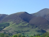
Carl Side
Encyclopedia
Fell
“Fell” is a word used to refer to mountains, or certain types of mountainous landscape, in Scandinavia, the Isle of Man, and parts of northern England.- Etymology :...
in the English
England
England is a country that is part of the United Kingdom. It shares land borders with Scotland to the north and Wales to the west; the Irish Sea is to the north west, the Celtic Sea to the south west, with the North Sea to the east and the English Channel to the south separating it from continental...
Lake District
Lake District
The Lake District, also commonly known as The Lakes or Lakeland, is a mountainous region in North West England. A popular holiday destination, it is famous not only for its lakes and its mountains but also for its associations with the early 19th century poetry and writings of William Wordsworth...
, forming a part of the Skiddaw
Skiddaw
Skiddaw is a mountain in the Lake District National Park in England. With a summit at 931 m above sea level it is the fourth highest mountain in England. It lies just north of the town of Keswick, Cumbria, and dominates the skyline in this part of the northern lakes...
"family" near the town of Keswick
Keswick, Cumbria
Keswick is a market town and civil parish within the Borough of Allerdale in Cumbria, England. It had a population of 4,984, according to the 2001 census, and is situated just north of Derwent Water, and a short distance from Bassenthwaite Lake, both in the Lake District National Park...
and prominently visible from its streets. It is listed in Alfred Wainwright
Alfred Wainwright
Alfred Wainwright MBE was a British fellwalker, guidebook author and illustrator. His seven-volume Pictorial Guide to the Lakeland Fells, published between 1955 and 1966 and consisting entirely of reproductions of his manuscript, has become the standard reference work to 214 of the fells of the...
's Pictorial Guides to the Lakeland Fells as one of the Northern Fells
Northern Fells
The Northern Fells are a group of hills in the English Lake District. Including Skiddaw, they occupy a wide area to the north of Keswick. Smooth sweeping slopes predominate with a minimum of tarns or crags...
.
Summit and View
The summit is a predominantly grassy plateau smoothly sloping away on all sides except to the north, where some shattered crags look down upon Southerndale. A small cairnCairn
Cairn is a term used mainly in the English-speaking world for a man-made pile of stones. It comes from the or . Cairns are found all over the world in uplands, on moorland, on mountaintops, near waterways and on sea cliffs, and also in barren desert and tundra areas...
marks the highest point. The view southward down Derwentwater is excellent, backed by a wide vista of fells from Clough Head
Clough Head
Clough Head is a fell in the English Lake District. It is the northernmost top of the Helvellyn range in the Eastern Fells, standing to the south of Threlkeld and the A66.-Topography:...
to Sale Fell
Sale Fell
Sale Fell is a small hill near Cockermouth in the English Lake District. It is one of the smallest Wainwrights, but is nevertheless popular with locals, as it offers gentle walking and lovely views across Bassenthwaite Lake to Skiddaw.-Topography:...
. Tewet Tarn on High Rigg
High Rigg
High Rigg is a small fell located in the English Lake District, approximately three miles southeast of the town of Keswick. It occupies an unusual position, surrounded on all sides by higher fells but not connected by any obvious ridge...
is the only other significant visible body of water. Nearer at hand the grey flanks of Skiddaw and Little Man loom above the summit.
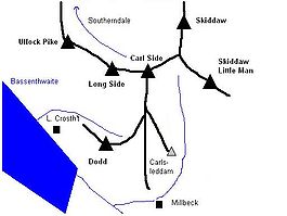
Topography
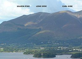
A ridge, known as Longside Edge, descends south-westward from the summit plateau of Skiddaw before swinging around to the west and finally north, descending the three fells of Carl Side, Long SideLong Side
Long Side is a fell in the English Lake District, it is situated six kilometres north west of Keswick in the northern sector of the national park and is part of the Skiddaw group of fells. Long Side which reaches a height of 734 m is located on Skiddaw’s north western ridge, the middle...
and Ullock Pike
Ullock Pike
Ullock Pike is a fell situated in northern part of the English Lake District. It is located seven kilometres north west of Keswick and achieves a height of 692 metres...
. Between Longside Edge and the mass of Skiddaw is the valley of Southerndale. Carl Side stands at the southern extremity of the curving ridge, having a triangular plan with ridges to the north-west, north-east and south.
To the north-east the fell is separated from Skiddaw by Carlside Col
Mountain pass
A mountain pass is a route through a mountain range or over a ridge. If following the lowest possible route, a pass is locally the highest point on that route...
(2,345 ft), a depression that contains Carlside Tarn
Tarn (lake)
A tarn is a mountain lake or pool, formed in a cirque excavated by a glacier. A moraine may form a natural dam below a tarn. A corrie may be called a cirque.The word is derived from the Old Norse word tjörn meaning pond...
, the only standing water found at any altitude in the Skiddaw group. Very shallow and frequently dry in summer, the tarn has no plant life. Set in a particularly windy location, the slight retaining bank at the south-eastern edge may be in danger of erosion. The Skiddaw side of the col is a rough scree slope while the Carl Side slope is gentler and grassed.
From the summit of Carl Side a system of ridges descends southward towards Millbeck. The main spur runs straight for a mile, the first half being of gentler gradient and culminating in a large patch of white stones at about 1,600 ft. There is a very short rocky arête
Arete
Areté is the term meaning "virtue" or "excellence", from Greek ἈρετήArete may also be used:*as a given name of persons or things:**Queen Arete , a character in Homer's Odyssey.***197 Arete, an asteroid....
here, before the spur falls abruptly to the valley floor. On the eastern side of this section are the crags of Doups. The southern ridge sends out shorter branches on either side, just above the patch of white stones. On the western side across the rocky col of Long Doors is Dodd
Dodd (Lake District)
Dodd is a small fell in the Lake District, Cumbria, England, four kilometres north-west of Keswick. It forms part of the Skiddaw range in the northern part of the national park and the slopes are heavily wooded.-Forestry:...
, a fell on Forestry Commission
Forestry Commission
The Forestry Commission is a non-ministerial government department responsible for forestry in Great Britain. Its mission is to protect and expand Britain's forests and woodlands and increase their value to society and the environment....
land that is largely wooded. To the east is Carlsleddam, a steep sided spur that appears sharply peaked from below: though less inspiring close up it does have a narrow and airy summit ridge.
The north-western connection to Long Side is a narrower ridge with rough ground to the north, bounding the head of Southerndale. Southerndale Beck, like all of the waters of Carl Side, ultimately finds its way to Bassenthwaite Lake
Bassenthwaite Lake
Bassenthwaite Lake is one of the largest water bodies in the English Lake District. It is long and narrow, approximately long and wide, but is also extremely shallow, with a maximum depth of about ....
, curving around the northern tip of Ullock Pike.
The eastern boundary of the fell is formed by Slade's Beck, a stream flowing over several dams and weirs to Millbeck. Across the valley is Skiddaw Little Man
Skiddaw Little Man
Skiddaw Little Man also called Little Man is a fell in the English Lake District, it is situated four kilometres north of the town of Keswick and reaches a height of 865 m .-Topography:...
. To the south west Skill Beck falls from Long Doors through a heavily forested valley between Carl Side and Dodd.
Geology and Mining
In common with much of the Northern Fells the Kirk Stile Formation of the Skiddaw Group predominates. This is composed of laminated mudstoneMudstone
Mudstone is a fine grained sedimentary rock whose original constituents were clays or muds. Grain size is up to 0.0625 mm with individual grains too small to be distinguished without a microscope. With increased pressure over time the platey clay minerals may become aligned, with the...
and siltstone
Siltstone
Siltstone is a sedimentary rock which has a grain size in the silt range, finer than sandstone and coarser than claystones.- Description :As its name implies, it is primarily composed of silt sized particles, defined as grains 1/16 - 1/256 mm or 4 to 8 on the Krumbein phi scale...
with greywacke
Greywacke
Greywacke or Graywacke is a variety of sandstone generally characterized by its hardness, dark color, and poorly sorted angular grains of quartz, feldspar, and small rock fragments or lithic fragments set in a compact, clay-fine matrix. It is a texturally immature sedimentary rock generally found...
sandstone and is of Ordovician
Ordovician
The Ordovician is a geologic period and system, the second of six of the Paleozoic Era, and covers the time between 488.3±1.7 to 443.7±1.5 million years ago . It follows the Cambrian Period and is followed by the Silurian Period...
age.
A trial level can be found in the little valley between Carlsleddam and the south ridge. This exploited a vein containing baryte and galena
Galena
Galena is the natural mineral form of lead sulfide. It is the most important lead ore mineral.Galena is one of the most abundant and widely distributed sulfide minerals. It crystallizes in the cubic crystal system often showing octahedral forms...
and operated in the 1870s.
Ascents
Carl Side is often climbed indirectly via Ullock Pike and Long Side, the narrow ridge providing a fine walk which is often continued to Skiddaw. Millbeck provides the nearest starting point, with variations possible via Carlsleddam, the south ridge, the intervening valley and Slade's Beck.A start can also be made from Little Crosthwaite, a small settlement at the foot of Dodd along the Carlisle road, climbing through the forestry to Long Doors before joining the south ridge. Indirect climbs via Dodd are also possible although the going can be very rough.
From High Side near Bassenthwaite an approach can be made along the length of Southerndale, ascending finally to Carlside Col.