
Knott
Encyclopedia
Knott is a mountain
in the northern part
of the English
Lake District
. It is the highest point of the Back o'Skiddaw region, an area of wild and unfrequented moorland
to the north of Skiddaw
and Blencathra
. Other tops in this region include High Pike
, Carrock Fell
and Great Calva
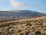
. The fell's slopes are mostly smooth, gentle, and covered in grass
, with a few deep ravine
s. It stands a long way from a road and requires a long walk across the moor top get to it; this, as well as the fact that it is hidden from the rest of the Lake District by the two aforementioned giants, make it one of the most unfrequented tops in the Lakes. When it is climbed it is most often from Mungrisdale
or from the north via Great Sca Fell
. The word Knott is of Cumbric
origin, and means simply "hill".
and the road to Penrith
. Behind this wall is a further group of fells, commonly referred to as Back o' Skiddaw. Knott stands at the centre of this group, in addition to being the highest point.
The Back o'Skiddaw group is separated from Blencathra and the Skiddaw massif by Skiddaw Forest. Confusingly this Forest contains no trees, —other than the windbreak of Skiddaw House — but is a marshy upland area at around 1,300 ft surrounded on all sides by higher fells. Three major streams flow from Skiddaw Forest, dividing the Northern Fells into three sectors. Dash Beck runs north west, the River Caldew north east and the River Glenderaterra south, between Skiddaw and Blencathra.
Knott itself is a long whale-backed ridge running for three miles in an east west direction. With the exception of the extreme east and west, the fell
has broad and gentle contours clad primarily in grass. Many of the streams draining it have cut deeply into Knott's flanks, exposing yellow and red soils which are visible in distant views.
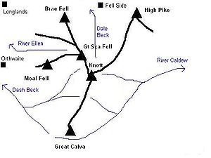 The western end of the fell is Burn Tod, which descends roughly between Burntod and Hause Gills, both tributaries of Dash Beck. To the north is a parallel but shorter shoulder, Frozen Fell, and these two spurs are the only part of the fell which drain westward to the River Derwent.
From the south of the summit a ridge descends across a narrow col to the neighbouring fell of Great Calva. A further spur on this flank, across to the east, is named Snab. Wiley Gill and Burdell Gill fall on this side to the River Caldew and, ultimately, the Eden at Carlisle.
The eastern terminus of the summit ridge is Coomb Height. At the base of the slope, amid rough ground, are the remains of Carrock Fell Mine. Coombe Height is bordered by Wet Swine Gill and Grainsgill Beck, further tributaries of the Caldew.
Two connecting ridges run north from Knott, separated by the deep ravines of Roughton Gill. The western arms drops across an area of bog and with little reascent arrives at the summit of Great Sca Fell. The eastern branch crosses Miller Moss and then runs at high level for two miles to High Pike, first passing the subsidiary tops of Great Lingy Hill and Harestones.
noted of the summit that "If the party consists of more than one person and if, further, a bat, ball and wickets can be found in the depths of somebody's rucksack, a cricket match can be played on turf many a county ground might covet." Amidst the grass a cairn
has been built. Further such markers adorn the tops of Coomb Height, Burn Tod and Snab, but the ridge top is otherwise featureless and the paths faint and intermittent.
The view southward is constrained by Blencathra and Skiddaw, neither displaying their best side, but between the two is a narrow slice of central Lakeland. This includes a section of distant Thirlmere
along with the Scafells
. To the north are the Solway Firth
and the hills of south west Scotland
, but there is little interest to the foreground.
Computer-generated summit panorama
mine outside Cornwall
and was operated at various times between 1850 and 1982 when the price of Tungsten was sufficient. Although reserves of Wolframite
and other tungsten ores are believed to remain, the Harding vein beneath Knott has long been worked out and the levels were used for dumping sludge from ore processing operations.
A small operation on the southern flank of Knott was Little Wiley Gill Mine. A 40 yard level was driven here, but no other information survives.
between Knott and Great Calva. Alternatively a start can be made at Longlands, crossing the intervening ridge between Meal Fell
and Great Cockup
and then following a path up between Burn Tod and Frozen Fell.
Fell Side provides access from the north, along the old mine track beside Roughten Gill. Once the mine is reached a pathless climb can be made to the summit.
The access road to Carrock Fell Mine can be used to lead onto Coomb Height for an ascent from Mosedale. Wainwright gave dire warnings regarding the mine workings on this route.
Mountain
Image:Himalaya_annotated.jpg|thumb|right|The Himalayan mountain range with Mount Everestrect 58 14 160 49 Chomo Lonzorect 200 28 335 52 Makalurect 378 24 566 45 Mount Everestrect 188 581 920 656 Tibetan Plateaurect 250 406 340 427 Rong River...
in the northern part
Northern Fells
The Northern Fells are a group of hills in the English Lake District. Including Skiddaw, they occupy a wide area to the north of Keswick. Smooth sweeping slopes predominate with a minimum of tarns or crags...
of the English
England
England is a country that is part of the United Kingdom. It shares land borders with Scotland to the north and Wales to the west; the Irish Sea is to the north west, the Celtic Sea to the south west, with the North Sea to the east and the English Channel to the south separating it from continental...
Lake District
Lake District
The Lake District, also commonly known as The Lakes or Lakeland, is a mountainous region in North West England. A popular holiday destination, it is famous not only for its lakes and its mountains but also for its associations with the early 19th century poetry and writings of William Wordsworth...
. It is the highest point of the Back o'Skiddaw region, an area of wild and unfrequented moorland
Moorland
Moorland or moor is a type of habitat, in the temperate grasslands, savannas, and shrublands biome, found in upland areas, characterised by low-growing vegetation on acidic soils and heavy fog...
to the north of Skiddaw
Skiddaw
Skiddaw is a mountain in the Lake District National Park in England. With a summit at 931 m above sea level it is the fourth highest mountain in England. It lies just north of the town of Keswick, Cumbria, and dominates the skyline in this part of the northern lakes...
and Blencathra
Blencathra
Blencathra, also known as Saddleback, is one of the most northerly mountains in the English Lake District. It has six separate fell tops, of which the highest is the Hallsfell Top.-Name:...
. Other tops in this region include High Pike
High Pike (Caldbeck)
High Pike is a fell in the northern part of the English Lake District, it is located 4.5 kilometres south of Caldbeck. It has a height of 658 metres and is the most northerly of the Lakeland fells over 2000 feet. It is a large fell with its northern slopes falling away towards the lower ground...
, Carrock Fell
Carrock Fell
Carrock Fell is a fell in the English Lake District, situated in the northern region of the national park 13 kilometres north east of Keswick. The fell's name means "Rocky Fell" and comes from a combination of the Old Welsh language with the word "carrec" meaning rock and the Old Norse language...
and Great Calva
Great Calva
Great Calva is a fell in the Lake District, England. It is in the Northern Fells, lying roughly at the centre of this region of high ground. As a result it is distant from roads and quite remote by Lakeland standards...
. The fell's slopes are mostly smooth, gentle, and covered in grass
Grass
Grasses, or more technically graminoids, are monocotyledonous, usually herbaceous plants with narrow leaves growing from the base. They include the "true grasses", of the Poaceae family, as well as the sedges and the rushes . The true grasses include cereals, bamboo and the grasses of lawns ...
, with a few deep ravine
Ravine
A ravine is a landform narrower than a canyon and is often the product of streamcutting erosion. Ravines are typically classified as larger in scale than gullies, although smaller than valleys. A ravine is generally a fluvial slope landform of relatively steep sides, on the order of twenty to...
s. It stands a long way from a road and requires a long walk across the moor top get to it; this, as well as the fact that it is hidden from the rest of the Lake District by the two aforementioned giants, make it one of the most unfrequented tops in the Lakes. When it is climbed it is most often from Mungrisdale
Mungrisdale
Mungrisdale is a small village and civil parish in the north east of the English Lake District in Cumbria. It is also the name of the valley in which the village sits....
or from the north via Great Sca Fell
Great Sca Fell
Great Sca Fell is a fell in the English Lake District, it stands seven kilometres southwest of the village of Caldbeck and is the highest of the four Uldale Fells .-Topography:...
. The word Knott is of Cumbric
Cumbric language
Cumbric was a variety of the Celtic British language spoken during the Early Middle Ages in the Hen Ogledd or "Old North", or what is now northern England and southern Lowland Scotland, the area anciently known as Cumbria. It was closely related to Old Welsh and the other Brythonic languages...
origin, and means simply "hill".
Topography
Skiddaw and Blencathra are the best known of the Northern Fells, fronting the range as they loom above KeswickKeswick, Cumbria
Keswick is a market town and civil parish within the Borough of Allerdale in Cumbria, England. It had a population of 4,984, according to the 2001 census, and is situated just north of Derwent Water, and a short distance from Bassenthwaite Lake, both in the Lake District National Park...
and the road to Penrith
Penrith, Cumbria
Penrith was an urban district between 1894 and 1974, when it was merged into Eden District.The authority's area was coterminous with the civil parish of Penrith although when the council was abolished Penrith became an unparished area....
. Behind this wall is a further group of fells, commonly referred to as Back o' Skiddaw. Knott stands at the centre of this group, in addition to being the highest point.
The Back o'Skiddaw group is separated from Blencathra and the Skiddaw massif by Skiddaw Forest. Confusingly this Forest contains no trees, —other than the windbreak of Skiddaw House — but is a marshy upland area at around 1,300 ft surrounded on all sides by higher fells. Three major streams flow from Skiddaw Forest, dividing the Northern Fells into three sectors. Dash Beck runs north west, the River Caldew north east and the River Glenderaterra south, between Skiddaw and Blencathra.
Knott itself is a long whale-backed ridge running for three miles in an east west direction. With the exception of the extreme east and west, the fell
Fell
“Fell” is a word used to refer to mountains, or certain types of mountainous landscape, in Scandinavia, the Isle of Man, and parts of northern England.- Etymology :...
has broad and gentle contours clad primarily in grass. Many of the streams draining it have cut deeply into Knott's flanks, exposing yellow and red soils which are visible in distant views.
From the south of the summit a ridge descends across a narrow col to the neighbouring fell of Great Calva. A further spur on this flank, across to the east, is named Snab. Wiley Gill and Burdell Gill fall on this side to the River Caldew and, ultimately, the Eden at Carlisle.
The eastern terminus of the summit ridge is Coomb Height. At the base of the slope, amid rough ground, are the remains of Carrock Fell Mine. Coombe Height is bordered by Wet Swine Gill and Grainsgill Beck, further tributaries of the Caldew.
Two connecting ridges run north from Knott, separated by the deep ravines of Roughton Gill. The western arms drops across an area of bog and with little reascent arrives at the summit of Great Sca Fell. The eastern branch crosses Miller Moss and then runs at high level for two miles to High Pike, first passing the subsidiary tops of Great Lingy Hill and Harestones.
Summit and view
WainwrightAlfred Wainwright
Alfred Wainwright MBE was a British fellwalker, guidebook author and illustrator. His seven-volume Pictorial Guide to the Lakeland Fells, published between 1955 and 1966 and consisting entirely of reproductions of his manuscript, has become the standard reference work to 214 of the fells of the...
noted of the summit that "If the party consists of more than one person and if, further, a bat, ball and wickets can be found in the depths of somebody's rucksack, a cricket match can be played on turf many a county ground might covet." Amidst the grass a cairn
Cairn
Cairn is a term used mainly in the English-speaking world for a man-made pile of stones. It comes from the or . Cairns are found all over the world in uplands, on moorland, on mountaintops, near waterways and on sea cliffs, and also in barren desert and tundra areas...
has been built. Further such markers adorn the tops of Coomb Height, Burn Tod and Snab, but the ridge top is otherwise featureless and the paths faint and intermittent.
The view southward is constrained by Blencathra and Skiddaw, neither displaying their best side, but between the two is a narrow slice of central Lakeland. This includes a section of distant Thirlmere
Thirlmere
Thirlmere is a reservoir in the Borough of Allerdale in Cumbria and the English Lake District. It runs roughly south to north, with a dam at the northern end, and is bordered on the eastern side by the A591 road and on the western side by a minor road....
along with the Scafells
Scafells
Image:Annotated Scafell range.jpg|thumb|right|300px|The Scafell range as seen looking west from Crinkle Crags. rect 23 372 252 419 Slight Side rect 173 794 560 834 Scafell East Buttress...
. To the north are the Solway Firth
Solway Firth
The Solway Firth is a firth that forms part of the border between England and Scotland, between Cumbria and Dumfries and Galloway. It stretches from St Bees Head, just south of Whitehaven in Cumbria, to the Mull of Galloway, on the western end of Dumfries and Galloway. The Isle of Man is also very...
and the hills of south west Scotland
Scotland
Scotland is a country that is part of the United Kingdom. Occupying the northern third of the island of Great Britain, it shares a border with England to the south and is bounded by the North Sea to the east, the Atlantic Ocean to the north and west, and the North Channel and Irish Sea to the...
, but there is little interest to the foreground.
Computer-generated summit panorama
Mining
Although the main part of Carrock Fell Mine is beneath Carrock Fell, there are some workings to the south of Grainsgill Beck at the base of Coomb Height. A trench runs northward down the slope to the beck, containing a number of shafts and levels. These surface workings follow the line of the Harding Vein, the most productive part of the mine. Carrock Fell Mine was the only British TungstenTungsten
Tungsten , also known as wolfram , is a chemical element with the chemical symbol W and atomic number 74.A hard, rare metal under standard conditions when uncombined, tungsten is found naturally on Earth only in chemical compounds. It was identified as a new element in 1781, and first isolated as...
mine outside Cornwall
Cornwall
Cornwall is a unitary authority and ceremonial county of England, within the United Kingdom. It is bordered to the north and west by the Celtic Sea, to the south by the English Channel, and to the east by the county of Devon, over the River Tamar. Cornwall has a population of , and covers an area of...
and was operated at various times between 1850 and 1982 when the price of Tungsten was sufficient. Although reserves of Wolframite
Wolframite
Wolframite WO4, is an iron manganese tungstate mineral that is the intermediate between ferberite and huebernite . Along with scheelite, the wolframite series are the most important tungsten ore minerals. Wolframite is found in quartz veins and pegmatites associated with granitic intrusives...
and other tungsten ores are believed to remain, the Harding vein beneath Knott has long been worked out and the levels were used for dumping sludge from ore processing operations.
A small operation on the southern flank of Knott was Little Wiley Gill Mine. A 40 yard level was driven here, but no other information survives.
Ascents
From Orthwaite to the north west a track can be followed to the source of Hause Gill and the colMountain pass
A mountain pass is a route through a mountain range or over a ridge. If following the lowest possible route, a pass is locally the highest point on that route...
between Knott and Great Calva. Alternatively a start can be made at Longlands, crossing the intervening ridge between Meal Fell
Meal Fell
Meal Fell is a small fell in the northern region of the English Lake District, it is situated seven kilometres south west of the village of Caldbeck and is one of the four main Uldale Fells ....
and Great Cockup
Great Cockup
Great Cockup is a fell in the northern region of the English Lake District, one of the four Uldale Fells .- Description :...
and then following a path up between Burn Tod and Frozen Fell.
Fell Side provides access from the north, along the old mine track beside Roughten Gill. Once the mine is reached a pathless climb can be made to the summit.
The access road to Carrock Fell Mine can be used to lead onto Coomb Height for an ascent from Mosedale. Wainwright gave dire warnings regarding the mine workings on this route.
See also
- Knott family of lighthouse keepers