
Blencathra
Encyclopedia
Blencathra, also known as Saddleback, is one of the most northerly mountains in the English
Lake District
. It has six separate fell tops, of which the highest is the 868 metres (2,847.8 ft) Hallsfell Top.
listed Blencathra under the alternative name of Saddleback, which was coined in reference to the shape of the mountain
when seen from the east. The guidebook author Alfred Wainwright
popularised the use of the older Cumbric name, which is now used almost exclusively. Ordnance Survey currently marks the summit as "Saddleback or Blencathra". It is likely that the name Blencathra is derived from the Cumbric elements blaen (a bare hill top) and cathrach (a chair). This would give a meaning of "the bare hill top shaped like a chair", which perfectly describes the topography
of the hill.
comprise a roughly circular upland area about 10 miles (16.1 km) wide. At the centre is the marshy depression of Skiddaw Forest — a treeless plateau at an altitude of 1,300 ft — and flowing outward from here are the rivers which divide the area into three sector
s. The south eastern sector, between the Glenderaterra Beck and the River Caldew
, contains Blencathra and its satellites.
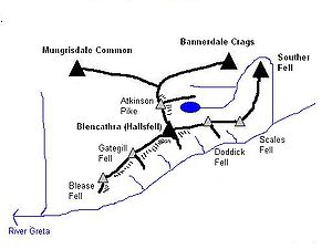
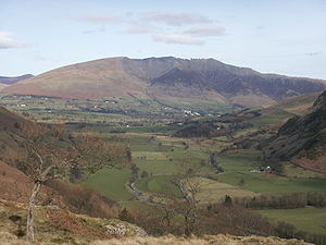
Blencathra is more of a small range than a single fell
, a series of tops standing out on a 3 miles (5 km) long curving ridge. It has smooth, easy slopes to the north and west, whilst displaying a complex system of rocky spurs and scree slopes to the south and east.
 When viewed from the south east, particularly on the main Keswick
to Penrith
road, Blencathra appears almost symmetrical. To left and right the ends of the fell rise from the surrounding lowlands in smooth and sweeping curves, clad in rough grass. Each rises gracefully to a ridge-top summit, Blease Fell on the west and Scales Fell to the east. Between these 'book-ends' are a further three tops, Gategill Fell, Hallsfell and Doddick Fell, giving a scalloped profile to the ridge. From each of the three central tops a spur runs out perpendicular to the main ridge, beginning as a narrow, rocky arête
and then widening into a broad buttress which falls 2000 ft (609.6 m) to the base of the fell. Separating the five tops are four streams which run down the south east face between the spurs. From the west these are Blease Gill, Gate Gill, Doddick Gill and Scaley Beck.
In addition to the spurs on the south east face, Hallsfell also throws out a high ridge to the north. This is the saddle that gives Blencathra its alternative name, rising beyond the dip to the sixth top, Atkinson Pike. This is the focal point for connecting ridges to Bannerdale Crags
and Mungrisdale Common
to the north. The 'saddle' is bounded by crags to the east, Tarn Crag and Foule Crag being the principal faces.
which provides one of the most famous scrambles in the area. Wainwright noted that
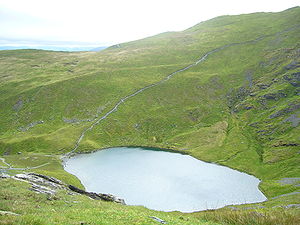 Below Tarn Crags is Scales Tarn
, an almost circular waterbody filling a corrie
. The bed plunges steeply to about 25 ft (7.6 m) and plants and fish are scarce.
To the east, beyond Scales Fell, is the connection to Souther Fell
at Mousthwaite Comb. This ridge continues north east to the vicinity of Mungrisdale, surrounded on all sides by the River Glenderamackin.
and siltstone
with greywacke
sandstone and is of Ordovician
age.
There has been considerable mining activity beneath the slopes of Blencathra. Threlkeld mine lies at the base of Hallsfell. From 1879 to 1928 it was a profitable venture for the raising of lead
and zinc
ores and is believed to hold further reserves should the economic situation improve.
A small trial working can be seen beside Blease Gill near the 2000 ft (609.6 m) contour. This is believed to have been driven for lead.
Saddleback Old Mine had workings near Scales Tarn and at Mousthwaite Comb. The mine was driven for lead but in the 1890s raised mostly limonite
. This was marketed unsuccessfully as a pigment and the mine closed in 1894.
In the Glenderaterra valley to the west of Blease Fell were Brundholme and Blencathra mines. Lead, copper
and baryte were raised between the middle of the nineteenth century and the final closure in 1920.
 The highest point is directly above the Hallsfell spur, marked by a sprawling cairn
only feet from the edge. A good path connects the five summits on the main ridge, giving excellent views down the south east face. Northward on the fine turf of the 'saddle' is a large cross laid out in white stones. Its origin is uncertain but extension to its current size (in excess of 10 ft) is attributed to a Harold Robinson of Threlkeld, a frequent visitor in the years after World War II
.
Computer-generated summit panorama
The view is very extensive, enhanced in every direction by the sharp fall of the slopes from the summit. To the west is the bulk of Skiddaw
, and from west round to north east the Back o'Skiddaw fells make up the foreground, backed by the mountains of Galloway
, the Southern Uplands
, the Border hills and the Cheviot
s.
The Pennines
form the horizon from north east to south east, with Cross Fell
, Mickle Fell
, Wild Boar Fell
and Great Whernside
visible. To the south east are the Far Eastern Fells
and to the south the Helvellyn range
is seen end-on, with vistas of the Forest of Bowland
and North Wales
to its left and right respectively.
The skyline from south to WSW is the best feature: a serrated skyline of all the major Lakeland peaks, these being, clockwise, Coniston Old Man, Crinkle Crags
, Bowfell
, Esk Pike
, Scafell Pike
, Great Gable
, Kirk Fell
, Pillar
, High Stile
, Grasmoor
and Grisedale Pike
. To the right of this the Isle of Man
and the Mourne Mountains are visible on clear days.
Derwent Water
and Thirlmere
are the major lakes visible; the most distant mountain visible is Slieve Meelmore in Mourne, 123 miles away.
on the eastern side of the mountain. Sharp Edge provides some good scrambling
for those with a head for heights. Hall's Fell ridge, on Blencathra’s southern flank, also provides an opportunity for some scrambling, though of a less serious nature. Wainwright described the ascent from Threlkeld via Hall's Fell ridge as "positively the finest way to any mountain-top in the district".
Wainwright recorded more routes of ascent for Blencathra than any other fell. Blease Fell and Scales Fell provided easy walking on grass and fast routes of descent. Gategill Fell he noted as dull until the final arête is reached, while Hallsfell and Doddick Fell both received praise. Of the intervening gills Scaley Beck was reckoned the most practicable, the other three being overly rough and devoid of interest. An ascent from 'behind', beginning from Mungrisdale, was also described.
England
England is a country that is part of the United Kingdom. It shares land borders with Scotland to the north and Wales to the west; the Irish Sea is to the north west, the Celtic Sea to the south west, with the North Sea to the east and the English Channel to the south separating it from continental...
Lake District
Lake District
The Lake District, also commonly known as The Lakes or Lakeland, is a mountainous region in North West England. A popular holiday destination, it is famous not only for its lakes and its mountains but also for its associations with the early 19th century poetry and writings of William Wordsworth...
. It has six separate fell tops, of which the highest is the 868 metres (2,847.8 ft) Hallsfell Top.
Name
For many years Ordnance SurveyOrdnance Survey
Ordnance Survey , an executive agency and non-ministerial government department of the Government of the United Kingdom, is the national mapping agency for Great Britain, producing maps of Great Britain , and one of the world's largest producers of maps.The name reflects its creation together with...
listed Blencathra under the alternative name of Saddleback, which was coined in reference to the shape of the mountain
Saddle
A saddle is a supportive structure for a rider or other load, fastened to an animal's back by a girth. The most common type is the equestrian saddle designed for a horse, but specialized saddles have been created for camels and other creatures...
when seen from the east. The guidebook author Alfred Wainwright
Alfred Wainwright
Alfred Wainwright MBE was a British fellwalker, guidebook author and illustrator. His seven-volume Pictorial Guide to the Lakeland Fells, published between 1955 and 1966 and consisting entirely of reproductions of his manuscript, has become the standard reference work to 214 of the fells of the...
popularised the use of the older Cumbric name, which is now used almost exclusively. Ordnance Survey currently marks the summit as "Saddleback or Blencathra". It is likely that the name Blencathra is derived from the Cumbric elements blaen (a bare hill top) and cathrach (a chair). This would give a meaning of "the bare hill top shaped like a chair", which perfectly describes the topography
Topography
Topography is the study of Earth's surface shape and features or those ofplanets, moons, and asteroids...
of the hill.
Topography
The Northern FellsNorthern Fells
The Northern Fells are a group of hills in the English Lake District. Including Skiddaw, they occupy a wide area to the north of Keswick. Smooth sweeping slopes predominate with a minimum of tarns or crags...
comprise a roughly circular upland area about 10 miles (16.1 km) wide. At the centre is the marshy depression of Skiddaw Forest — a treeless plateau at an altitude of 1,300 ft — and flowing outward from here are the rivers which divide the area into three sector
Circular sector
A circular sector or circle sector, is the portion of a disk enclosed by two radii and an arc, where the smaller area is known as the minor sector and the larger being the major sector. In the diagram, θ is the central angle in radians, r the radius of the circle, and L is the arc length of the...
s. The south eastern sector, between the Glenderaterra Beck and the River Caldew
River Caldew
The River Caldew is a river running through Cumbria in England. Historically, the county watered by the Caldew was Cumberland.The Caldew's source is high up on Skiddaw, between the summit and Sale How, in the Lake District, from where it runs east through a valley between Bowscale Fell and Carrock...
, contains Blencathra and its satellites.
Blencathra is more of a small range than a single fell
Fell
“Fell” is a word used to refer to mountains, or certain types of mountainous landscape, in Scandinavia, the Isle of Man, and parts of northern England.- Etymology :...
, a series of tops standing out on a 3 miles (5 km) long curving ridge. It has smooth, easy slopes to the north and west, whilst displaying a complex system of rocky spurs and scree slopes to the south and east.
Keswick, Cumbria
Keswick is a market town and civil parish within the Borough of Allerdale in Cumbria, England. It had a population of 4,984, according to the 2001 census, and is situated just north of Derwent Water, and a short distance from Bassenthwaite Lake, both in the Lake District National Park...
to Penrith
Penrith, Cumbria
Penrith was an urban district between 1894 and 1974, when it was merged into Eden District.The authority's area was coterminous with the civil parish of Penrith although when the council was abolished Penrith became an unparished area....
road, Blencathra appears almost symmetrical. To left and right the ends of the fell rise from the surrounding lowlands in smooth and sweeping curves, clad in rough grass. Each rises gracefully to a ridge-top summit, Blease Fell on the west and Scales Fell to the east. Between these 'book-ends' are a further three tops, Gategill Fell, Hallsfell and Doddick Fell, giving a scalloped profile to the ridge. From each of the three central tops a spur runs out perpendicular to the main ridge, beginning as a narrow, rocky arête
Arete
Areté is the term meaning "virtue" or "excellence", from Greek ἈρετήArete may also be used:*as a given name of persons or things:**Queen Arete , a character in Homer's Odyssey.***197 Arete, an asteroid....
and then widening into a broad buttress which falls 2000 ft (609.6 m) to the base of the fell. Separating the five tops are four streams which run down the south east face between the spurs. From the west these are Blease Gill, Gate Gill, Doddick Gill and Scaley Beck.
In addition to the spurs on the south east face, Hallsfell also throws out a high ridge to the north. This is the saddle that gives Blencathra its alternative name, rising beyond the dip to the sixth top, Atkinson Pike. This is the focal point for connecting ridges to Bannerdale Crags
Bannerdale Crags
Bannerdale Crags is a fell in the English Lake District. It stands between Blencathra and Bowscale Fell in the Northern Fells.-Topography:Bannerdale Crags is a ridge running north west to south east...
and Mungrisdale Common
Mungrisdale Common
Mungrisdale Common, pronounced mun-grize-dl, with emphasis on grize, is a fell in the English Lake District. Although Alfred Wainwright listed it as one of the 214 featured hills in his influential Pictorial Guide to the Lakeland Fells it was his least favourite. He commented that it "has no more...
to the north. The 'saddle' is bounded by crags to the east, Tarn Crag and Foule Crag being the principal faces.
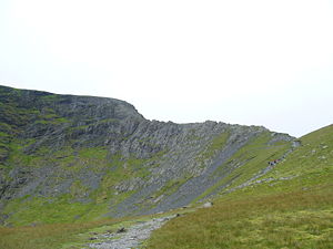
Sharp edge
Between Tarn Crag and Foule Crag is Sharp Edge, an aptly named arêteArete
Areté is the term meaning "virtue" or "excellence", from Greek ἈρετήArete may also be used:*as a given name of persons or things:**Queen Arete , a character in Homer's Odyssey.***197 Arete, an asteroid....
which provides one of the most famous scrambles in the area. Wainwright noted that
- The crest itself is sharp enough for shaving (the former name was razor edge) and can be traversed only à cheval at some risk of damage to tender parts.
Tarn
Tarn is a department of 5,758 km2 in the Midi-Pyrénées region in the southwest of France, named after the Tarn River. It was formed in 1790 of the three dioceses of Albi, Castres and Lavaur, belonging to the province of Languedoc. In 1906, the population was 330,533...
, an almost circular waterbody filling a corrie
Cirque
Cirque may refer to:* Cirque, a geological formation* Makhtesh, an erosional landform found in the Negev desert of Israel and Sinai of Egypt*Cirque , an album by Biosphere* Cirque Corporation, a company that makes touchpads...
. The bed plunges steeply to about 25 ft (7.6 m) and plants and fish are scarce.
To the east, beyond Scales Fell, is the connection to Souther Fell
Souther Fell
Souther Fell is a fell in the English Lake District. It stands to the south of Mungrisdale village in the Northern Fells. It is most famous for the appearance of a "spectral army", said to have been seen marching along its crest on Midsummer's Day, 1745...
at Mousthwaite Comb. This ridge continues north east to the vicinity of Mungrisdale, surrounded on all sides by the River Glenderamackin.
Geology and mining
In common with much of the Northern Fells the Kirk Stile Formation of the Skiddaw Group predominates. This is composed of laminated mudstoneMudstone
Mudstone is a fine grained sedimentary rock whose original constituents were clays or muds. Grain size is up to 0.0625 mm with individual grains too small to be distinguished without a microscope. With increased pressure over time the platey clay minerals may become aligned, with the...
and siltstone
Siltstone
Siltstone is a sedimentary rock which has a grain size in the silt range, finer than sandstone and coarser than claystones.- Description :As its name implies, it is primarily composed of silt sized particles, defined as grains 1/16 - 1/256 mm or 4 to 8 on the Krumbein phi scale...
with greywacke
Greywacke
Greywacke or Graywacke is a variety of sandstone generally characterized by its hardness, dark color, and poorly sorted angular grains of quartz, feldspar, and small rock fragments or lithic fragments set in a compact, clay-fine matrix. It is a texturally immature sedimentary rock generally found...
sandstone and is of Ordovician
Ordovician
The Ordovician is a geologic period and system, the second of six of the Paleozoic Era, and covers the time between 488.3±1.7 to 443.7±1.5 million years ago . It follows the Cambrian Period and is followed by the Silurian Period...
age.
There has been considerable mining activity beneath the slopes of Blencathra. Threlkeld mine lies at the base of Hallsfell. From 1879 to 1928 it was a profitable venture for the raising of lead
Lead
Lead is a main-group element in the carbon group with the symbol Pb and atomic number 82. Lead is a soft, malleable poor metal. It is also counted as one of the heavy metals. Metallic lead has a bluish-white color after being freshly cut, but it soon tarnishes to a dull grayish color when exposed...
and zinc
Zinc
Zinc , or spelter , is a metallic chemical element; it has the symbol Zn and atomic number 30. It is the first element in group 12 of the periodic table. Zinc is, in some respects, chemically similar to magnesium, because its ion is of similar size and its only common oxidation state is +2...
ores and is believed to hold further reserves should the economic situation improve.
A small trial working can be seen beside Blease Gill near the 2000 ft (609.6 m) contour. This is believed to have been driven for lead.
Saddleback Old Mine had workings near Scales Tarn and at Mousthwaite Comb. The mine was driven for lead but in the 1890s raised mostly limonite
Limonite
Limonite is an ore consisting in a mixture of hydrated iron oxide-hydroxide of varying composition. The generic formula is frequently written as FeO·nH2O, although this is not entirely accurate as limonite often contains a varying amount of oxide compared to hydroxide.Together with hematite, it has...
. This was marketed unsuccessfully as a pigment and the mine closed in 1894.
In the Glenderaterra valley to the west of Blease Fell were Brundholme and Blencathra mines. Lead, copper
Copper
Copper is a chemical element with the symbol Cu and atomic number 29. It is a ductile metal with very high thermal and electrical conductivity. Pure copper is soft and malleable; an exposed surface has a reddish-orange tarnish...
and baryte were raised between the middle of the nineteenth century and the final closure in 1920.
Summit and view
Cairn
Cairn is a term used mainly in the English-speaking world for a man-made pile of stones. It comes from the or . Cairns are found all over the world in uplands, on moorland, on mountaintops, near waterways and on sea cliffs, and also in barren desert and tundra areas...
only feet from the edge. A good path connects the five summits on the main ridge, giving excellent views down the south east face. Northward on the fine turf of the 'saddle' is a large cross laid out in white stones. Its origin is uncertain but extension to its current size (in excess of 10 ft) is attributed to a Harold Robinson of Threlkeld, a frequent visitor in the years after World War II
World War II
World War II, or the Second World War , was a global conflict lasting from 1939 to 1945, involving most of the world's nations—including all of the great powers—eventually forming two opposing military alliances: the Allies and the Axis...
.
Computer-generated summit panorama
The view is very extensive, enhanced in every direction by the sharp fall of the slopes from the summit. To the west is the bulk of Skiddaw
Skiddaw
Skiddaw is a mountain in the Lake District National Park in England. With a summit at 931 m above sea level it is the fourth highest mountain in England. It lies just north of the town of Keswick, Cumbria, and dominates the skyline in this part of the northern lakes...
, and from west round to north east the Back o'Skiddaw fells make up the foreground, backed by the mountains of Galloway
Galloway
Galloway is an area in southwestern Scotland. It usually refers to the former counties of Wigtownshire and Kirkcudbrightshire...
, the Southern Uplands
Southern Uplands
The Southern Uplands are the southernmost and least populous of mainland Scotland's three major geographic areas . The term is used both to describe the geographical region and to collectively denote the various ranges of hills within this region...
, the Border hills and the Cheviot
The Cheviot
The Cheviot is the highest summit in the Cheviot Hills in the far north of England, only 2 km from the Scottish border. It is the last major peak on the Pennine Way, if travelling from south to north, before the descent into Kirk Yetholm....
s.
The Pennines
Pennines
The Pennines are a low-rising mountain range, separating the North West of England from Yorkshire and the North East.Often described as the "backbone of England", they form a more-or-less continuous range stretching from the Peak District in Derbyshire, around the northern and eastern edges of...
form the horizon from north east to south east, with Cross Fell
Cross Fell
Cross Fell is the highest point in the Pennine Hills of northern England and the highest point in England outside of the Lake District.The summit, at , is a stony plateau, part of a long ridge running North West to South East, which also incorporates Little Dun Fell at and Great Dun Fell at...
, Mickle Fell
Mickle Fell
Mickle Fell is a mountain in the Pennines, the range of hills and moors running down the middle of Northern England. It is 788 m high and lies slightly off the main watershed of the Pennines, about ten miles south of Cross Fell....
, Wild Boar Fell
Wild Boar Fell
Wild Boar Fell is a mountain in Mallerstang on the eastern edge of Cumbria, England. At , it is either the 4th highest fell in the Yorkshire Dales or the 5th, whether counting nearby High Seat or not...
and Great Whernside
Great Whernside
Great Whernside is a mountain in the Yorkshire Dales, England, not to be confused with the better known Whernside, some to the west. Its summit is the highest point of the eastern flank of Wharfedale above Kettlewell...
visible. To the south east are the Far Eastern Fells
Far Eastern Fells
The Far Eastern Fells are a group of hills in the English Lake District. Reaching their highest point at High Street they occupy a broad area to the east of Ullswater and Kirkstone Pass. Much quieter than the central areas of Lakeland they offer in general easier but less exciting walking as the...
and to the south the Helvellyn range
Helvellyn range
Helvellyn range is the name given to a part of the Eastern Fells in the English Lake District, fell being the local word for hill. The name comes from Helvellyn, the highest point of the group....
is seen end-on, with vistas of the Forest of Bowland
Forest of Bowland
The Forest of Bowland, also known as the Bowland Fells, is an area of barren gritstone fells, deep valleys and peat moorland, mostly in north-east Lancashire, England. A small part lies in North Yorkshire, and much of the area was historically part of the West Riding of Yorkshire...
and North Wales
Wales
Wales is a country that is part of the United Kingdom and the island of Great Britain, bordered by England to its east and the Atlantic Ocean and Irish Sea to its west. It has a population of three million, and a total area of 20,779 km²...
to its left and right respectively.
The skyline from south to WSW is the best feature: a serrated skyline of all the major Lakeland peaks, these being, clockwise, Coniston Old Man, Crinkle Crags
Crinkle Crags
Crinkle Crags is a fell in the English Lake District in the county of Cumbria. It forms part of two major rings of mountains, surrounding the valleys of Great Langdale and Upper Eskdale. The name reflects the fell's physical appearance as its summit ridge is a series of five rises and depressions ...
, Bowfell
Bowfell
Bowfell is a pyramid-shaped mountain lying at the heart of the English Lake District, in the Southern Fells area. It is the sixth highest mountain in the lakes and one of the most popular of the Lake District fells...
, Esk Pike
Esk Pike
Esk Pike is a fell in the English Lake District, one of the great cirque of hills forming the head of Eskdale.-Topography:The Southern Fells include the highest ground in England, a horseshoe which begins with Scafell and Scafell Pike in the west and then curves around the north of Upper Eskdale to...
, Scafell Pike
Scafell Pike
Scafell Pike is the highest mountain in England at . It is located in Lake District National Park sometimes confused with the neighbouring Sca Fell, to which it is connected by the col of Mickledore...
, Great Gable
Great Gable
Great Gable is a mountain lying at the very heart of the English Lake District, appearing as a pyramid from Wasdale , but as a dome from most other directions. It is one of the most popular of the Lakeland fells, and there are many different routes to the summit...
, Kirk Fell
Kirk Fell
Kirk Fell is a fell in the Western part of the English Lake District. It is situated between Great Gable and Pillar on the long ring of fells surrounding the valley of Ennerdale, and also stands over Wasdale to the south...
, Pillar
Pillar (Lake District)
Pillar is a mountain in the western part of the English Lake District. Situated between the valleys of Ennerdale to the north and Wasdale to the south, it is the highest point of the Pillar group . At 892 metres it is the eighth highest mountain in the Lake District...
, High Stile
High Stile
High Stile is a mountain in the western part of the Lake District in northwest England. It is the eleventh highest English Marilyn, standing 807 metres high, and has a relative height of 362 metres ....
, Grasmoor
Grasmoor
Grasmoor is a mountain in the north-western part of the Lake District, northern England. It is the highest peak in a group of hills between the villages of Lorton, Braithwaite and Buttermere, and overlooks Crummock Water....
and Grisedale Pike
Grisedale Pike
Grisedale Pike is a fell in the Lake District, Cumbria, England situated west of the town of Keswick in the north-western sector of the national park. At a height of 791 m it is the 40th highest Wainwright in the Lake District; it also qualifies as a Hewitt, Marilyn and Nuttall...
. To the right of this the Isle of Man
Isle of Man
The Isle of Man , otherwise known simply as Mann , is a self-governing British Crown Dependency, located in the Irish Sea between the islands of Great Britain and Ireland, within the British Isles. The head of state is Queen Elizabeth II, who holds the title of Lord of Mann. The Lord of Mann is...
and the Mourne Mountains are visible on clear days.
Derwent Water
Derwent Water
Derwentwater is one of the principal bodies of water in the Lake District National Park in north west England. It lies wholly within the Borough of Allerdale, in the county of Cumbria....
and Thirlmere
Thirlmere
Thirlmere is a reservoir in the Borough of Allerdale in Cumbria and the English Lake District. It runs roughly south to north, with a dam at the northern end, and is bordered on the eastern side by the A591 road and on the western side by a minor road....
are the major lakes visible; the most distant mountain visible is Slieve Meelmore in Mourne, 123 miles away.
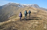
Ascents
Blencathra is a popular mountain, and there are many different routes to the summit. One of the most famous is via Sharp Edge, a knife-edged arêteArete
Areté is the term meaning "virtue" or "excellence", from Greek ἈρετήArete may also be used:*as a given name of persons or things:**Queen Arete , a character in Homer's Odyssey.***197 Arete, an asteroid....
on the eastern side of the mountain. Sharp Edge provides some good scrambling
Scrambling
Scrambling is a method of ascending rocky faces and ridges. It is an ambiguous term that lies somewhere between hillwalking and rock climbing. It is often distinguished from hillwalking by defining a scramble as a route where hands must be used in the ascent...
for those with a head for heights. Hall's Fell ridge, on Blencathra’s southern flank, also provides an opportunity for some scrambling, though of a less serious nature. Wainwright described the ascent from Threlkeld via Hall's Fell ridge as "positively the finest way to any mountain-top in the district".
Wainwright recorded more routes of ascent for Blencathra than any other fell. Blease Fell and Scales Fell provided easy walking on grass and fast routes of descent. Gategill Fell he noted as dull until the final arête is reached, while Hallsfell and Doddick Fell both received praise. Of the intervening gills Scaley Beck was reckoned the most practicable, the other three being overly rough and devoid of interest. An ascent from 'behind', beginning from Mungrisdale, was also described.