
Latrigg
Encyclopedia
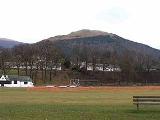
Latrigg is one of the lowest fell
s in the Lake District
, but is a popular climb due to its convenient location overlooking the town of Keswick
and the beautiful views down the valley of Borrowdale
from the summit. It is the least mountainous of the Skiddaw
fells, the summit being almost entirely devoid of rock. The slopes of Latrigg are partially wooded, and logging work is currently being undertaken. One lone tree just south of the summit is prominently viewed in silhouette when approaching Keswick from the west along the A66
.
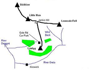
as a whole. It takes the form of a rounded hump at the terminus of a long descending ridge, and would be unremarkable if not for its location. To the north of Latrigg summit is an unnamed depression at about 970 ft and rising beyond is a grassy rigg, climbing up to Jenkin Hill and the top of Skiddaw Little Man
. Latrigg itself sends out a narrow ridge to the east, about a mile long and ending at Brundholm.
The fell is bordered by the two streams falling from the northern col
. Gale Gill runs west to join the River Derwent between Derwentwater and Bassenthwaite Lake
. The unnamed eastern stream joins Whit Beck and then flows into the River Greta, bound again for the Derwent via Keswick.
The steep southern slopes are cloaked in the mixed woodland of Brundholme Wood and Whinny Brow, Latriggs only crags being hidden in the trees. A public road from Keswick contours across this slope at around 600 ft, giving access to the farms of Lonscale and Brundholm. Further mixed woodland has been planted on the north eastern slopes above Whit Beck. To the north west, on either bank of Gale Gill, are the conifer plantations of Birkett Wood and Mallen Dodd. A single track road climbs up the slope beside the wood, giving access to a car park on the depression to the north of the fell.
and siltstone
with greywacke
sandstone and is of Ordovician
age.
The view northward is of the high grassy flanks of Skiddaw and Blencathra
, impressive but lacking detail. To the south the contrast is total. Looking out over Keswick and down the full length of Derwentwater, the eye is drawn to Borrowdale and the high fells of Central Lakeland. Wainwright
was moved to describe "a panorama of crowded detail, all of it of great beauty: indeed this scene is one of the gems of the district...The far horizon is a jumbled upheaval of peaks, with many dear old friends standing up proudly."
Computer generated summit panorama.
is another starting point, first crossing the Glenderaterra Beck and then climbing up the east ridge. The easiest way is to park at the end of Gale Road, from where the summit is a simple 10 minute stroll on grass, the most accessible of all the 214 Wainwrights. This car park is commonly used as the starting point for the ascent of Skiddaw, although the purist will first climb Latrigg from Keswick before setting foot upon its parent. A recently constructed path allows disabled access to the summit of Latrigg from the car park.
Fell
“Fell” is a word used to refer to mountains, or certain types of mountainous landscape, in Scandinavia, the Isle of Man, and parts of northern England.- Etymology :...
s in the Lake District
Lake District
The Lake District, also commonly known as The Lakes or Lakeland, is a mountainous region in North West England. A popular holiday destination, it is famous not only for its lakes and its mountains but also for its associations with the early 19th century poetry and writings of William Wordsworth...
, but is a popular climb due to its convenient location overlooking the town of Keswick
Keswick, Cumbria
Keswick is a market town and civil parish within the Borough of Allerdale in Cumbria, England. It had a population of 4,984, according to the 2001 census, and is situated just north of Derwent Water, and a short distance from Bassenthwaite Lake, both in the Lake District National Park...
and the beautiful views down the valley of Borrowdale
Borrowdale
Borrowdale is a valley and civil parish in the English Lake District in the Borough of Allerdale in Cumbria, England.Borrowdale lies within the historic county boundaries of Cumberland, and is sometimes referred to as Cumberland Borrowdale in order to distinguish it from another Borrowdale in the...
from the summit. It is the least mountainous of the Skiddaw
Skiddaw
Skiddaw is a mountain in the Lake District National Park in England. With a summit at 931 m above sea level it is the fourth highest mountain in England. It lies just north of the town of Keswick, Cumbria, and dominates the skyline in this part of the northern lakes...
fells, the summit being almost entirely devoid of rock. The slopes of Latrigg are partially wooded, and logging work is currently being undertaken. One lone tree just south of the summit is prominently viewed in silhouette when approaching Keswick from the west along the A66
A66 road
The A66 is a major road in northern England which in part follows the course of the Roman road from Scotch Corner to Penrith. It runs from east of Middlesbrough in the ceremonial county of North Yorkshire to Workington in Cumbria...
.
Topography
Latrigg is the most southerly top of the Skiddaw massif and of the Northern FellsNorthern Fells
The Northern Fells are a group of hills in the English Lake District. Including Skiddaw, they occupy a wide area to the north of Keswick. Smooth sweeping slopes predominate with a minimum of tarns or crags...
as a whole. It takes the form of a rounded hump at the terminus of a long descending ridge, and would be unremarkable if not for its location. To the north of Latrigg summit is an unnamed depression at about 970 ft and rising beyond is a grassy rigg, climbing up to Jenkin Hill and the top of Skiddaw Little Man
Skiddaw Little Man
Skiddaw Little Man also called Little Man is a fell in the English Lake District, it is situated four kilometres north of the town of Keswick and reaches a height of 865 m .-Topography:...
. Latrigg itself sends out a narrow ridge to the east, about a mile long and ending at Brundholm.
The fell is bordered by the two streams falling from the northern col
Mountain pass
A mountain pass is a route through a mountain range or over a ridge. If following the lowest possible route, a pass is locally the highest point on that route...
. Gale Gill runs west to join the River Derwent between Derwentwater and Bassenthwaite Lake
Bassenthwaite Lake
Bassenthwaite Lake is one of the largest water bodies in the English Lake District. It is long and narrow, approximately long and wide, but is also extremely shallow, with a maximum depth of about ....
. The unnamed eastern stream joins Whit Beck and then flows into the River Greta, bound again for the Derwent via Keswick.
The steep southern slopes are cloaked in the mixed woodland of Brundholme Wood and Whinny Brow, Latriggs only crags being hidden in the trees. A public road from Keswick contours across this slope at around 600 ft, giving access to the farms of Lonscale and Brundholm. Further mixed woodland has been planted on the north eastern slopes above Whit Beck. To the north west, on either bank of Gale Gill, are the conifer plantations of Birkett Wood and Mallen Dodd. A single track road climbs up the slope beside the wood, giving access to a car park on the depression to the north of the fell.
Geology
In common with much of the Northern Fells the Kirk Stile Formation of the Skiddaw Group predominates. This is composed of laminated mudstoneMudstone
Mudstone is a fine grained sedimentary rock whose original constituents were clays or muds. Grain size is up to 0.0625 mm with individual grains too small to be distinguished without a microscope. With increased pressure over time the platey clay minerals may become aligned, with the...
and siltstone
Siltstone
Siltstone is a sedimentary rock which has a grain size in the silt range, finer than sandstone and coarser than claystones.- Description :As its name implies, it is primarily composed of silt sized particles, defined as grains 1/16 - 1/256 mm or 4 to 8 on the Krumbein phi scale...
with greywacke
Greywacke
Greywacke or Graywacke is a variety of sandstone generally characterized by its hardness, dark color, and poorly sorted angular grains of quartz, feldspar, and small rock fragments or lithic fragments set in a compact, clay-fine matrix. It is a texturally immature sedimentary rock generally found...
sandstone and is of Ordovician
Ordovician
The Ordovician is a geologic period and system, the second of six of the Paleozoic Era, and covers the time between 488.3±1.7 to 443.7±1.5 million years ago . It follows the Cambrian Period and is followed by the Silurian Period...
age.
Summit and View
The top of the fell is sheep pasture, falling gently to the north and quite steeply to the south. Some stumps remain at the top of the southern slope as evidence of past deforestation, together with few small trees, bent down by the prevailing wind. A ditch and parapet run across the top. The parapet was the base of a fence, long since decayed, and the ditch was the source of the earth for its construction.The view northward is of the high grassy flanks of Skiddaw and Blencathra
Blencathra
Blencathra, also known as Saddleback, is one of the most northerly mountains in the English Lake District. It has six separate fell tops, of which the highest is the Hallsfell Top.-Name:...
, impressive but lacking detail. To the south the contrast is total. Looking out over Keswick and down the full length of Derwentwater, the eye is drawn to Borrowdale and the high fells of Central Lakeland. Wainwright
Alfred Wainwright
Alfred Wainwright MBE was a British fellwalker, guidebook author and illustrator. His seven-volume Pictorial Guide to the Lakeland Fells, published between 1955 and 1966 and consisting entirely of reproductions of his manuscript, has become the standard reference work to 214 of the fells of the...
was moved to describe "a panorama of crowded detail, all of it of great beauty: indeed this scene is one of the gems of the district...The far horizon is a jumbled upheaval of peaks, with many dear old friends standing up proudly."
Computer generated summit panorama.
Ascents
Commonly Latrigg is ascended from Keswick, the route beginning along Spooney Green Lane near the old railway station and then either making direct for the top or swinging north via Mallen Dodd. ThrelkeldThrelkeld
Threlkeld is a village and civil parish in the north of the Lake District in Cumbria, England, to the east of Keswick. It lies at the southern foot of Blencathra, one of the more prominent fells in the northern Lake District, and to the north of the River Glenderamackin.Historically a part of...
is another starting point, first crossing the Glenderaterra Beck and then climbing up the east ridge. The easiest way is to park at the end of Gale Road, from where the summit is a simple 10 minute stroll on grass, the most accessible of all the 214 Wainwrights. This car park is commonly used as the starting point for the ascent of Skiddaw, although the purist will first climb Latrigg from Keswick before setting foot upon its parent. A recently constructed path allows disabled access to the summit of Latrigg from the car park.