

Far Eastern Fells
Encyclopedia

England
England is a country that is part of the United Kingdom. It shares land borders with Scotland to the north and Wales to the west; the Irish Sea is to the north west, the Celtic Sea to the south west, with the North Sea to the east and the English Channel to the south separating it from continental...
Lake District
Lake District
The Lake District, also commonly known as The Lakes or Lakeland, is a mountainous region in North West England. A popular holiday destination, it is famous not only for its lakes and its mountains but also for its associations with the early 19th century poetry and writings of William Wordsworth...
. Reaching their highest point at High Street
High Street (Lake District)
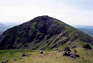
High Street is a fell in the English Lake District. At 828 metres , its summit is the highest point in the far eastern part of the national park. The fell is named after the Roman road which ran over the summit.-History and Naming:...
(828 metres or 2,718 ft) they occupy a broad area to the east of Ullswater
Ullswater
Ullswater is the second largest lake in the English Lake District, being approximately nine miles long and 0.75 miles wide with a maximum depth of slightly more than ....
and Kirkstone Pass
Kirkstone Pass
Kirkstone Pass is a mountain pass in the English Lake District, in the county of Cumbria. It is at an altitude of .This is the Lake District's highest pass that is open to motor traffic and it connects Ambleside in the Rothay Valley to Patterdale in the Ullswater Valley - the A592 road. In places,...
. Much quieter than the central areas of Lakeland they offer in general easier but less exciting walking as the fells merge mainly into the surrounding moorlands. Exceptions however are the fine rock scenery to be seen on Harter Fell
Harter Fell (Mardale)
Harter Fell is a fell in the far eastern part of the English Lake District. The summit at lies the meeting point of three ridges, and Harter Fell forms the head of three valleys: Mardale, Longsleddale and the valley of the River Kent.-Topography:...
, Mardale Ill Bell
Mardale Ill Bell
Mardale Ill Bell is a fell in the English Lake District, rising to the south west of Haweswater Reservoir. It stands on the watershed between Mardale and Kentmere and is the highpoint of the south eastern ridge of High Street, midway on its course to Harter Fell.-Topography:The head of the Kentmere...
and High Street
High Street (Lake District)
High Street is a fell in the English Lake District. At 828 metres , its summit is the highest point in the far eastern part of the national park. The fell is named after the Roman road which ran over the summit.-History and Naming:...
surrounding the head of Haweswater
Haweswater Reservoir
Haweswater is a reservoir in the English Lake District, built in the valley of Mardale in the county of Cumbria. The controversial construction of the Haweswater dam started in 1929, after Parliament passed an Act giving the Manchester Corporation permission to build the reservoir to supply water...
Partition of the Lakeland Fells
National park
A national park is a reserve of natural, semi-natural, or developed land that a sovereign state declares or owns. Although individual nations designate their own national parks differently A national park is a reserve of natural, semi-natural, or developed land that a sovereign state declares or...
in the north west of the country which, in addition to its lake
Lake
A lake is a body of relatively still fresh or salt water of considerable size, localized in a basin, that is surrounded by land. Lakes are inland and not part of the ocean and therefore are distinct from lagoons, and are larger and deeper than ponds. Lakes can be contrasted with rivers or streams,...
s, contains a complex range of hills. These are locally known as fells and range from low hills to the highest ground in England. Hundreds of tops exist and many writers have attempted to draw up definitive lists
Hill lists in the British Isles
The mountains and hills of Great Britain, and to a lesser extent Ireland, are the subject of a considerable number of lists that categorise them by height, topographic prominence, or other criteria. They are commonly used as a basis for peak bagging, whereby hillwalkers attempt to reach all the...
. In doing so the compilers frequently divide the range into smaller areas to aid their description.
The most influential of all such authors was Alfred Wainwright
Alfred Wainwright
Alfred Wainwright MBE was a British fellwalker, guidebook author and illustrator. His seven-volume Pictorial Guide to the Lakeland Fells, published between 1955 and 1966 and consisting entirely of reproductions of his manuscript, has become the standard reference work to 214 of the fells of the...
whose Pictorial Guide to the Lakeland Fells
Pictorial Guide to the Lakeland Fells
A Pictorial Guide to the Lakeland Fells is a series of seven books by A. Wainwright, detailing the fells of the Lake District in northwest England...
series has sold in excess of 2 million copies, being in print continuously since the first volume was published in 1952. Wainwright divided the fells into seven geographical areas, each surrounded by valleys and low passes. While any such division must be arbitrary — and later writers have deviated to a greater or lesser extent from this blueprint — Wainwright's sevenfold division remains the best known partitioning of the fells into 'sub ranges', each with its own characteristics. The Far Eastern Fells are one of these divisions, covered by volume 2 of Wainwright's work.
Boundaries
The Far Eastern Fells occupy the region east of the A592 Kirkstone PassKirkstone Pass
Kirkstone Pass is a mountain pass in the English Lake District, in the county of Cumbria. It is at an altitude of .This is the Lake District's highest pass that is open to motor traffic and it connects Ambleside in the Rothay Valley to Patterdale in the Ullswater Valley - the A592 road. In places,...
road. This runs north from Ambleside
Ambleside
Ambleside is a town in Cumbria, in North West England.Historically within the county of Westmorland, it is situated at the head of Windermere, England's largest lake...
to Patterdale
Patterdale
Patterdale is a small village and civil parish in the eastern part of the English Lake District in the Eden District of Cumbria, and the long valley in which they are found, also called the Ullswater Valley....
at the head of Ullswater
Ullswater
Ullswater is the second largest lake in the English Lake District, being approximately nine miles long and 0.75 miles wide with a maximum depth of slightly more than ....
. The western perimeter then continues down the length of the lake to Pooley Bridge
Pooley Bridge
Pooley Bridge is a village in the Eden District of the northwestern English county of Cumbria, within the traditional borders of Westmorland....
. Wainwright's outer boundary was more arbitrary since he chose not to mirror the edge of the National Park
Lake District National Park
The Lake District National Park is located in the north-west of England and is the largest of the English National Parks and the second largest in the United Kingdom. It is in the central and most-visited part of the Lake District....
as he was "concerned only with the high ground".
He determined instead upon straight lines connecting the outer limits of Ullswater and Haweswater
Haweswater Reservoir
Haweswater is a reservoir in the English Lake District, built in the valley of Mardale in the county of Cumbria. The controversial construction of the Haweswater dam started in 1929, after Parliament passed an Act giving the Manchester Corporation permission to build the reservoir to supply water...
, the proposed (and never built) Swindale Reservoir and Windermere
Windermere (lake)
Windermere is the largest natural lake in England. It is a ribbon lake formed in a glacial trough after the retreat of ice at the start of the current interglacial. It has been one of the country’s most popular places for holidays and summer homes since the arrival of the Kendal and Windermere...
. He extended this area slightly by stretching the boundary out to Longsleddale
Longsleddale
Longsleddale is a valley and civil parish in the South Lakeland district of the English county of Cumbria. It includes the hamlet of Sadgill. The parish has a population of 73....
church, thus bringing in Tarn Crag
Tarn Crag (Far Eastern Fells)
Tarn Crag is a fell in the English Lake District. It stands to the east of Longsleddale in the Far Eastern Fells. There is another Tarn Crag in the Central Fells near Grasmere.-Topography:...
and Grey Crag
Grey Crag
Grey Crag is a fell in the English Lake District. It stands to the east of Longsleddale in the Far Eastern Fells. There is another fell named Gray Crag in the Lake District near Hartsop.-Topography:...
, the most easterly 2,000 footers. Wainwright thus excluded the high moorland falling eastward to the M6 Motorway
M6 motorway
The M6 motorway runs from junction 19 of the M1 at the Catthorpe Interchange, near Rugby via Birmingham then heads north, passing Stoke-on-Trent, Manchester, Preston, Carlisle and terminating at the Gretna junction . Here, just short of the Scottish border it becomes the A74 which continues to...
, although later writers such as Birkett have included everything to the park boundary.
Topography

Eastern Fells
The Eastern Fells are a group of hills in the English Lake District. Centred on Helvellyn they primarily comprise a north south ridge running between Ullswater and Lakeland's Central Valley.-Partition of the Lakeland Fells:...
on the other side of Kirkstone. First, directly above the Inn at the summit of the pass, is Stony Cove Pike
Stony Cove Pike
Stony Cove Pike is a fell in the Far Eastern part of the English Lake District. It stands on the other side of the Kirkstone Pass from Red Screes, and is on the end of a ridge coming down from High Street...
, known to devotees of Wainwright by its alternative name of Caudale Moor. Swinging gradually northward the ridge continues over Thornthwaite Crag
Thornthwaite Crag
Thornthwaite Crag is a fell in the English Lake District, standing to the west of Haweswater Reservoir. It is a focal point of the Far Eastern Fells, standing at the head of several valleys.-Topography:...
, High Street
High Street (Lake District)
High Street is a fell in the English Lake District. At 828 metres , its summit is the highest point in the far eastern part of the national park. The fell is named after the Roman road which ran over the summit.-History and Naming:...
, Rampsgill Head
Rampsgill Head
Rampsgill Head is a fell in the English Lake District, standing to the west of Haweswater Reservoir in the Far Eastern Fells. It forms the focal point of three ridges which fan out north east, north west and south.-Topography:...
and High Raise
High Raise (High Street)
High Raise is a fell in the English Lake District, standing to the west of Haweswater Reservoir in the Far Eastern Fells. Note that another High Raise is the highpoint of the Central Fells.-Topography:...
. The western, Ullswater, side of the ridge is characterised by the steep U-shaped valleys of Martindale
Martindale, Cumbria
Martindale is a valley and civil parish in Cumbria, England, situated within the Lake District National Park between the lakes of Ullswater and Haweswater...
running north to the lake, rough grass, heather and bracken being the principal terrain. On the eastern flanks are deep corries, sharp ridges and a great deal of exposed rock, looking down on the Haweswater Reservoir
Haweswater Reservoir
Haweswater is a reservoir in the English Lake District, built in the valley of Mardale in the county of Cumbria. The controversial construction of the Haweswater dam started in 1929, after Parliament passed an Act giving the Manchester Corporation permission to build the reservoir to supply water...
. North of High Raise the ridge descends gradually northward, gradually assuming a moorland character as it passes over Wether Hill
Wether Hill (Lake District)
Wether Hill is a fell in the English Lake District, between Martindale and Haweswater. It lies on the main north-south ridge of the Far Eastern Fells between Loadpot Hill and High Raise. Lesser ridges also radiate out to the east and north-west.-Topography:...
and Loadpot Hill
Loadpot Hill
Loadpot Hill is a fell in the English Lake District, between Haweswater and Ullswater.-Topography:Although of moderate height, Loadpot Hill and its descending ridges cover an area of around...
before petering out altogether near Pooley Bridge. Only above the shore of Ullswater does a trace of Lakeland remain, with the steep faces of Arthur's Pike
Arthur's Pike
Arthur's Pike is a fell in the English Lake District, near Ullswater. It is a subsidiary top on the ridge falling north from Loadpot Hill in the Far Eastern Fells. An extensive craggy face stands above the lower reach of Ullswater.-Topography:...
and Bonscale Pike
Bonscale Pike
Bonscale Pike is a fell in the English Lake District, standing above Howtown on Ullswater. It is the northern end of a spur running north north west from Loadpot Hill on the main ridge of the Far Eastern Fells.-Topography:...
looming over the lake.
The complex valley system of Martindale lies on the western side of the main ridge, the dales divided by ridges which fan out from Rampsgill Head. Here the walker will find The Knott
The Knott
The Knott is a fell in the English Lake District, standing above Hayeswater in the Far Eastern Fells. It is an outlier of Rampsgill Head, being the high point of the ridge from there to Rest Dodd.-Topography:...
and Rest Dodd
Rest Dodd
Rest Dodd is a fell in the English Lake District. It is situated in the quieter far eastern region of the national park and reaches a height of 696 metres...
falling from the higher ground, beyond which are The Nab
The Nab
The Nab is a fell in the English Lake District. It has a moderate height of 576 metres , and lies in the quieter eastern high ground between Ullswater and Haweswater Reservoir...
, Brock Crags
Brock Crags
Brock Crags is a fell in the English Lake District, standing above Hartsop in the Far Eastern Fells. It forms part of the perimeter of Martindale, lying on the long ridge from Rampsgill Head to Place Fell.-Location of summit:...
and Beda Fell
Beda Fell
Beda Fell is a fell in the English Lake District, situated to the south of Ullswater. It divides the valleys of Boredale and Bannerdale within the Martindale system.-Topography:...
. Completing the group above Patterdale are Angletarn Pikes
Angletarn Pikes
Angletarn Pikes, is a fell in the English Lake District, near the village of Patterdale. Its most notable feature is the summit tarn from which it derives its name.-Topography:...
with its beautiful indented tarn
Tarn (lake)
A tarn is a mountain lake or pool, formed in a cirque excavated by a glacier. A moraine may form a natural dam below a tarn. A corrie may be called a cirque.The word is derived from the Old Norse word tjörn meaning pond...
and Place Fell
Place Fell
Place Fell is a hill in the English Lake District. It stands at the corner of the upper and middle reaches of Ullswater, with steep western flanks overlooking the villages of Glenridding and Patterdale.-Topography:...
. Steel Knotts
Steel Knotts
Steel Knotts is a fell in the English Lake District, near to Ullswater in the Far Eastern Fells. It stands between the valleys of Fusedale and Martindale on a ridge running north-south.-Topography:...
and Hallin Fell
Hallin Fell
Hallin Fell is a hill in the English Lake District surrounded on three sides by Ullswater.-Topography:The fell is a continuation of the ridge leading down from Steel Knotts, but the depression at The Coombs is so profound that Hallin Fell appears totally independent in almost any view...
also rise to the west of the main range, satellites of Wether Hill.

Ill Crag
Ill Crag is a fell in the English Lake District. By some counts it is the fourth highest peak in England, although many people, including Alfred Wainwright, consider it to be a subsidiary summit of Scafell Pike...
, Froswick
Froswick
Froswick is a fell in the English Lake District, standing on the fine narrow ridge between the valleys of Kentmere and Troutbeck.-Topography:To the north is Thornthwaite Crag, while the adjoining fell to the south is Ill Bell. Froswick is shorter in stature than either of its neighbours and also...
and Yoke
Yoke (Lake District)
Yoke is a fell in the Lake District in Cumbria, England. It has a height of 706 m and is situated in the far eastern sector of the national park, 7 kilometres north east of the town of Ambleside. Yoke is the southern extremity of the long ridge that runs southwards from the fell of High...
. To the east are Mardale Ill Bell
Mardale Ill Bell
Mardale Ill Bell is a fell in the English Lake District, rising to the south west of Haweswater Reservoir. It stands on the watershed between Mardale and Kentmere and is the highpoint of the south eastern ridge of High Street, midway on its course to Harter Fell.-Topography:The head of the Kentmere...
, Harter Fell
Harter Fell (Mardale)
Harter Fell is a fell in the far eastern part of the English Lake District. The summit at lies the meeting point of three ridges, and Harter Fell forms the head of three valleys: Mardale, Longsleddale and the valley of the River Kent.-Topography:...
, Kentmere Pike
Kentmere Pike
Kentmere Pike is a fell in the English Lake District, rising between the valleys of Kentmere and Longsleddale. It is the highpoint on the ridge between Harter Fell and Shipman Knotts.-Topography:...
and Shipman Knotts
Shipman Knotts
Shipman Knotts is a fell in the English Lake District in Cumbria, England. It reaches a height of 587 m and is situated in one of the quieter areas of the national park, two kilometres north east of Kentmere village...
. Eastward again are the parallel valley of Longsleddale and the further ridge running from Branstree
Branstree
Branstree is a fell in the Far Eastern part of the English Lake District. It overlooks the valley of Mardale and Haweswater Reservoir.-Topography:...
to Grey Crag
Grey Crag
Grey Crag is a fell in the English Lake District. It stands to the east of Longsleddale in the Far Eastern Fells. There is another fell named Gray Crag in the Lake District near Hartsop.-Topography:...
.
Harter Fell turns its smoother back to Kentmere, saving its more impressive side for the head of Mardale, the valley holding Haweswater. Before the lake was raised by a dam in the 1930s the small village of Mardale Green stood at the head of the valley, now only revealed in time of drought. Feeding the lake from either side of Mardale Ill Bell are the corrie tarns of Small Water and Blea Water, the latter being the deepest tarn in Lakeland.
Access for walkers
Patterdale and Glenridding provide a good base to the north west, walks via Boredale Hause being possible along the ridges all the way to High Street. From Ambleside to the southwest the lower hills around Troutbeck are within easy reach. Martindale can be reached either by the Ullswater steamer or a long drive around the lake, Place Fell and Hallin Fell being particular favourites from this direction.To the east of the group there are fewer facilities, particularly since the demise of habitation within Mardale. A car park has however been provided at the head of the lake which brings the great arc of fells from Branstree round to High Raise into range. Mardale Head is also the northern terminus of two important walkers passes, Nan Bield to Kentmere and Gatesgarth to Longsleddale. Both of these quiet valleys also allow car access part way along, although in the summer months an extended bus service is provided for walkers. Expeditions into the group via the extreme eastern valleys result in long walks over unfrequented moorland. The ridges surrounding Bannisdale, Crookdale, Wet Sleddale or Naddle Beck can be considered, although no other human is likely to be seen all day.
See also
- Eastern FellsEastern FellsThe Eastern Fells are a group of hills in the English Lake District. Centred on Helvellyn they primarily comprise a north south ridge running between Ullswater and Lakeland's Central Valley.-Partition of the Lakeland Fells:...
- Central FellsCentral FellsThe Central Fells are a group of hills in the English Lake District. Reaching their highest point at High Raise , they occupy a broad area to the east of Borrowdale. Perhaps unexpectedly the Central Fells are generally lower than the surrounding hills, the Lake District's general dome-like...
- Southern FellsSouthern FellsImage:Annotated Scafell range.jpg|thumb|300px|The Scafellsrect 23 372 252 419 Slight Side rect 173 794 560 834 Scafell East Buttressrect 707 787 893 861 Esk Pike or Crag rect 245 303 409 358 Sca Fell rect 408 238 637 280 Mickledore Image:Annotated Scafell range.jpg|thumb|300px|The Scafellsrect 23...
- Northern FellsNorthern FellsThe Northern Fells are a group of hills in the English Lake District. Including Skiddaw, they occupy a wide area to the north of Keswick. Smooth sweeping slopes predominate with a minimum of tarns or crags...
- North Western FellsNorth Western FellsThe North Western Fells are a group of hills in the English Lake District. Including such favourites as Catbells and Grisedale Pike, they occupy an oval area beneath the Buttermere and Borrowdale valley systems...
- Western FellsWestern FellsThe Western Fells are a group of hills in the English Lake District. Centred on Great Gable they occupy a triangular area between Buttermere and Wasdale...