
Bowscale Fell
Encyclopedia
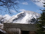
Bowscale Fell is a hill in the English
Lake District
. It rises above the village of Mungrisdale
in the Northern Fells
. Bowscale Fell stands at the extreme north east the Blencathra
group, connected to this higher fell
by the intervening Bannerdale Crags
. In common with many fells the western slopes are smooth and convex while the eastern side exhibits crags.
in the north. Bannerdale flows due east from the depression between the two fells to its junction with the River Glenderamackin. A second tributary of the Glenderamackin, Bullfell Beck, runs parallel a little to the north, its source being directly beneath the summit of Bowscale Fell. The heads of the two valleys are divided by a truncated east ridge, The Tongue, which sports a top (1,814 ft) at the far end. From below, The Tongue appears as an impressive pyramidal peak with steep slopes on all sides, obscuring the higher ground behind.
A second, longer eastern ridge runs out to the north of Bowscale Fell, forming the northern wall of Bullfell Beck. This has two subsidiary tops at 2,017 ft and 1,981 ft and ends steeply at Raven Crag above the Mungrisdale
to Heskett Newmarket road. Perched in a bowl scooped out on the northern face of this ridge is Bowscale Tarn. This is a classic corrie
tarn, held in by a whalebacked moraine
and having a depth of around 60 ft. Bowscale Tarn was a popular tourist attraction in Victorian
times, visitors being brought by pony to observe its wild and moody setting. Tastes change and the tarn now finds itself on few itineries for a grand tour of the District. Legend had it that the tarn was home to two immortal fish, one version of the tale also crediting them with the gift of speech. Above the water is Tarn Crag, the steepest face on the fell.
The western and northern flanks of the fell drain to the River Caldew, which heads north east to Carlisle for a meeting with the River Eden, and thence to the Solway Firth
. Northward across the deep cutting of the Caldew is Carrock Fell
, while to the west are Great Calva
and Knott
. Wainwright remarked that the western slopes of Bowscale Fell are drained by the Caldew which ultimately flows to the east, while the eastern slopes feed the Glenderamackin which soon turns west for Keswick
and the River Derwent.
Being on the Derwent - Eden watershed, Bowscale Fell has further topographical significance by providing the link between the Northern and Eastern Fells. The eastern ridge continues almost imperceptibly beneath Raven Crag, crossing the road before rising again to form Little Eycott and Eycott Hills. From here the watershed runs south across Great Mell Fell
and ultimately climbs onto Great Dodd
in the Helvellyn range
.
a little to the north, marking the direction of Bowscale Tarn. The view of Blencathra and Sharp Edge is excellent, together with a surprising vista of the North Western Fells
through the Glenderaterra gap.
If a much longer walk is required, the ridge between Bowscale Fell and Bannerdale Crags can be reached from the Caldew Valley to the west. This makes Mosedale, or even Skiddaw House and points west into possible starting points.
England
England is a country that is part of the United Kingdom. It shares land borders with Scotland to the north and Wales to the west; the Irish Sea is to the north west, the Celtic Sea to the south west, with the North Sea to the east and the English Channel to the south separating it from continental...
Lake District
Lake District
The Lake District, also commonly known as The Lakes or Lakeland, is a mountainous region in North West England. A popular holiday destination, it is famous not only for its lakes and its mountains but also for its associations with the early 19th century poetry and writings of William Wordsworth...
. It rises above the village of Mungrisdale
Mungrisdale
Mungrisdale is a small village and civil parish in the north east of the English Lake District in Cumbria. It is also the name of the valley in which the village sits....
in the Northern Fells
Northern Fells
The Northern Fells are a group of hills in the English Lake District. Including Skiddaw, they occupy a wide area to the north of Keswick. Smooth sweeping slopes predominate with a minimum of tarns or crags...
. Bowscale Fell stands at the extreme north east the Blencathra
Blencathra
Blencathra, also known as Saddleback, is one of the most northerly mountains in the English Lake District. It has six separate fell tops, of which the highest is the Hallsfell Top.-Name:...
group, connected to this higher fell
Fell
“Fell” is a word used to refer to mountains, or certain types of mountainous landscape, in Scandinavia, the Isle of Man, and parts of northern England.- Etymology :...
by the intervening Bannerdale Crags
Bannerdale Crags
Bannerdale Crags is a fell in the English Lake District. It stands between Blencathra and Bowscale Fell in the Northern Fells.-Topography:Bannerdale Crags is a ridge running north west to south east...
. In common with many fells the western slopes are smooth and convex while the eastern side exhibits crags.
Topography
A curving ridge surrounds the head of Bannerdale, with Bowscale Fell at the northern end and Bannerdale Crags to the south. The ridgeline is broad and grassy with occasional patches of bog and a couple of small tarnsTarn (lake)
A tarn is a mountain lake or pool, formed in a cirque excavated by a glacier. A moraine may form a natural dam below a tarn. A corrie may be called a cirque.The word is derived from the Old Norse word tjörn meaning pond...
in the north. Bannerdale flows due east from the depression between the two fells to its junction with the River Glenderamackin. A second tributary of the Glenderamackin, Bullfell Beck, runs parallel a little to the north, its source being directly beneath the summit of Bowscale Fell. The heads of the two valleys are divided by a truncated east ridge, The Tongue, which sports a top (1,814 ft) at the far end. From below, The Tongue appears as an impressive pyramidal peak with steep slopes on all sides, obscuring the higher ground behind.
A second, longer eastern ridge runs out to the north of Bowscale Fell, forming the northern wall of Bullfell Beck. This has two subsidiary tops at 2,017 ft and 1,981 ft and ends steeply at Raven Crag above the Mungrisdale
Mungrisdale
Mungrisdale is a small village and civil parish in the north east of the English Lake District in Cumbria. It is also the name of the valley in which the village sits....
to Heskett Newmarket road. Perched in a bowl scooped out on the northern face of this ridge is Bowscale Tarn. This is a classic corrie
Cirque
Cirque may refer to:* Cirque, a geological formation* Makhtesh, an erosional landform found in the Negev desert of Israel and Sinai of Egypt*Cirque , an album by Biosphere* Cirque Corporation, a company that makes touchpads...
tarn, held in by a whalebacked moraine
Moraine
A moraine is any glacially formed accumulation of unconsolidated glacial debris which can occur in currently glaciated and formerly glaciated regions, such as those areas acted upon by a past glacial maximum. This debris may have been plucked off a valley floor as a glacier advanced or it may have...
and having a depth of around 60 ft. Bowscale Tarn was a popular tourist attraction in Victorian
Victorian era
The Victorian era of British history was the period of Queen Victoria's reign from 20 June 1837 until her death on 22 January 1901. It was a long period of peace, prosperity, refined sensibilities and national self-confidence...
times, visitors being brought by pony to observe its wild and moody setting. Tastes change and the tarn now finds itself on few itineries for a grand tour of the District. Legend had it that the tarn was home to two immortal fish, one version of the tale also crediting them with the gift of speech. Above the water is Tarn Crag, the steepest face on the fell.
The western and northern flanks of the fell drain to the River Caldew, which heads north east to Carlisle for a meeting with the River Eden, and thence to the Solway Firth
Solway Firth
The Solway Firth is a firth that forms part of the border between England and Scotland, between Cumbria and Dumfries and Galloway. It stretches from St Bees Head, just south of Whitehaven in Cumbria, to the Mull of Galloway, on the western end of Dumfries and Galloway. The Isle of Man is also very...
. Northward across the deep cutting of the Caldew is Carrock Fell
Carrock Fell
Carrock Fell is a fell in the English Lake District, situated in the northern region of the national park 13 kilometres north east of Keswick. The fell's name means "Rocky Fell" and comes from a combination of the Old Welsh language with the word "carrec" meaning rock and the Old Norse language...
, while to the west are Great Calva
Great Calva
Great Calva is a fell in the Lake District, England. It is in the Northern Fells, lying roughly at the centre of this region of high ground. As a result it is distant from roads and quite remote by Lakeland standards...
and Knott
Knott
Knott is a mountain in the northern part of the English Lake District. It is the highest point of the Back o'Skiddaw region, an area of wild and unfrequented moorland to the north of Skiddaw and Blencathra. Other tops in this region include High Pike, Carrock Fell and Great Calva. The fell's slopes...
. Wainwright remarked that the western slopes of Bowscale Fell are drained by the Caldew which ultimately flows to the east, while the eastern slopes feed the Glenderamackin which soon turns west for Keswick
Keswick, Cumbria
Keswick is a market town and civil parish within the Borough of Allerdale in Cumbria, England. It had a population of 4,984, according to the 2001 census, and is situated just north of Derwent Water, and a short distance from Bassenthwaite Lake, both in the Lake District National Park...
and the River Derwent.
Being on the Derwent - Eden watershed, Bowscale Fell has further topographical significance by providing the link between the Northern and Eastern Fells. The eastern ridge continues almost imperceptibly beneath Raven Crag, crossing the road before rising again to form Little Eycott and Eycott Hills. From here the watershed runs south across Great Mell Fell
Great Mell Fell
Great Mell Fell is a hill in the Eastern Fells of the English Lake District. It is a north-eastern outlier of the Helvellyn range, but, like its twin Little Mell Fell, is isolated from its fellows, standing in the middle of a flat plain...
and ultimately climbs onto Great Dodd
Great Dodd
Great Dodd is a fell in the English Lake District. It stands on the main spine of the Helvellyn range in the Eastern Fells, between the Vale of St John and Dockray.-Topography:...
in the Helvellyn range
Helvellyn range
Helvellyn range is the name given to a part of the Eastern Fells in the English Lake District, fell being the local word for hill. The name comes from Helvellyn, the highest point of the group....
.
Summit and View
The summit of the fell bears a rash of stones although all else is grass. There is a windshelter at the highest point and a cairnCairn
Cairn is a term used mainly in the English-speaking world for a man-made pile of stones. It comes from the or . Cairns are found all over the world in uplands, on moorland, on mountaintops, near waterways and on sea cliffs, and also in barren desert and tundra areas...
a little to the north, marking the direction of Bowscale Tarn. The view of Blencathra and Sharp Edge is excellent, together with a surprising vista of the North Western Fells
North Western Fells
The North Western Fells are a group of hills in the English Lake District. Including such favourites as Catbells and Grisedale Pike, they occupy an oval area beneath the Buttermere and Borrowdale valley systems...
through the Glenderaterra gap.
Ascents
A number of alternatives are available when starting from Mungrisdale. The easiest follows a gently rising track to the depression at the head of Bannerdale, while a variation is to turn off and climb steeply up the terminal slope of The Tongue. Bullfell Beck can also be followed to give the most direct ascent to the summit, but the best route is perhaps to follow the east ridge over its undulating tops. From Bowscale, a little along the road to the north, the Victorian pony route to Bowscale Tarn can still be followed, continuing up a grassy rake that bisects Tarn Crag.If a much longer walk is required, the ridge between Bowscale Fell and Bannerdale Crags can be reached from the Caldew Valley to the west. This makes Mosedale, or even Skiddaw House and points west into possible starting points.