
Longlands Fell
Encyclopedia
Fell
“Fell” is a word used to refer to mountains, or certain types of mountainous landscape, in Scandinavia, the Isle of Man, and parts of northern England.- Etymology :...
in the northern part
Northern Fells
The Northern Fells are a group of hills in the English Lake District. Including Skiddaw, they occupy a wide area to the north of Keswick. Smooth sweeping slopes predominate with a minimum of tarns or crags...
of the English Lake District
Lake District
The Lake District, also commonly known as The Lakes or Lakeland, is a mountainous region in North West England. A popular holiday destination, it is famous not only for its lakes and its mountains but also for its associations with the early 19th century poetry and writings of William Wordsworth...
. It is situated in the high ground known as the Uldale Fells, 5.5 kilometres south west of the village of Caldbeck
Caldbeck
Caldbeck is a village and civil parish in the Borough of Allerdale, Cumbria, England. Historically within Cumberland, the village had 714 inhabitants according to the census of 2001. It lies on the northern edge of the Lake District. The nearest town is Wigton, 6 miles north east of the village...
. It reaches a height of 483 m (1,585 ft) and it is (along with Binsey
Binsey
Binsey is a hill on the northern edge of the Lake District in Cumbria, England. It is detached from the rest of the Lakeland hills, and thus provides a good spot to look out at the Northern and North Western Fells of the Lake District, as well as the coastal plain and, across the Solway Firth,...
) the most northerly fell in the Lake District.
Topography
Longlands Fell is characterised by grassy, smooth slopes which drop down gradually to the lowlands north of Lakeland making the ascent of the fell quite easy from that direction. The other Uldale Fells are Great Sca FellGreat Sca Fell
Great Sca Fell is a fell in the English Lake District, it stands seven kilometres southwest of the village of Caldbeck and is the highest of the four Uldale Fells .-Topography:...
, Great Cockup
Great Cockup
Great Cockup is a fell in the northern region of the English Lake District, one of the four Uldale Fells .- Description :...
and Meal Fell
Meal Fell
Meal Fell is a small fell in the northern region of the English Lake District, it is situated seven kilometres south west of the village of Caldbeck and is one of the four main Uldale Fells ....
and together are really just one big sheep pasture which does not draw large numbers of fell walkers or visitors, making this probably the quietest part of the national park, the border of which is only two kilometres to the north.
Mining
Unlike the adjacent Caldbeck Fells, which were heavily minedMining
Mining is the extraction of valuable minerals or other geological materials from the earth, from an ore body, vein or seam. The term also includes the removal of soil. Materials recovered by mining include base metals, precious metals, iron, uranium, coal, diamonds, limestone, oil shale, rock...
for minerals, the Uldale Fells have only ever had one mine on them and that was on Longlands Fell. The Longlands Fell copper mine operated in the second half of the 19th century but was soon found to be uneconomical and abandoned, one of the levels is now dammed to provide water to the village of Uldale. Just to the north of Longlands Fell on the adjoining small Aughtertree Fell (300 metres) are signs of an Iron Age
Iron Age
The Iron Age is the archaeological period generally occurring after the Bronze Age, marked by the prevalent use of iron. The early period of the age is characterized by the widespread use of iron or steel. The adoption of such material coincided with other changes in society, including differing...
farming settlement first settled 3,000 years ago and probably deserted during the Dark Ages.
Ascents
Longlands Fell is one the easier fell walks in the Lake District, the ascent starts from the hamlet of Longlands, which is a small group of houses and takes the track north east which skirts the base of the fell, this is part of the low level alternative of the Cumbria WayCumbria Way
The Cumbria Way is a linear long distance footpath in Cumbria, England passing through the towns of Coniston and Keswick. It also passes through the Langdale and Borrowdale valleys...
, when the foot of the northern ridge is reached this is followed up easy slopes to reach the summit. Longlands Fell is often climbed in conjunction with other fells, being connected to the south east by a 2.5 kilometre ridge to Great Sca Fell which in turn gives access along its ridges to the rest of the fells in the area.
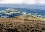
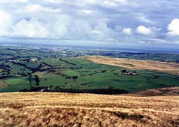
View
The view from the top takes in the Solway FirthSolway Firth
The Solway Firth is a firth that forms part of the border between England and Scotland, between Cumbria and Dumfries and Galloway. It stretches from St Bees Head, just south of Whitehaven in Cumbria, to the Mull of Galloway, on the western end of Dumfries and Galloway. The Isle of Man is also very...
and the Galloway
Galloway
Galloway is an area in southwestern Scotland. It usually refers to the former counties of Wigtownshire and Kirkcudbrightshire...
hills to the north. To the south are good views of Skiddaw
Skiddaw
Skiddaw is a mountain in the Lake District National Park in England. With a summit at 931 m above sea level it is the fourth highest mountain in England. It lies just north of the town of Keswick, Cumbria, and dominates the skyline in this part of the northern lakes...
with the fells around the Whinlatter forest well seen.