
Binsey
Encyclopedia
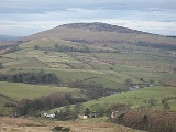
Binsey is a hill on the northern edge of the Lake District
in Cumbria
, England
. It is detached from the rest of the Lakeland hills, and thus provides a good spot to look out at the Northern
and North Western Fells
of the Lake District, as well as the coastal plain and, across the Solway Firth
, Scotland
. Snaefell
on The Isle of Man is also visible on a clear day.
in the main massif of the Northern Fells, two miles to the south east. Binsey itself has a rounded form, but somehow manages to impress the eye more than the similar Great Mell Fell
and Little Mell Fell
.
The "pudding basin" shape holds all around Binsey except to the north west where a ridge descends over Whitas Park to a depression containing the remains of a Roman
fort. Beyond is St John's Hill (950 ft) (called Caermote Hill in Wainwright's Outlying Fells
) which is topped by an earthwork called "The Battery". Finally the ridge descends to the village of Bothel
in the Ellen Valley.
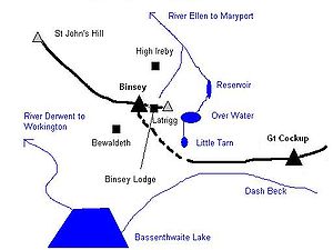
Binsey sends out a further spur to the east, culminating in the shapely top of Latrigg (1,030 ft)— not to be confused with Latrigg
near Keswick
. Beneath Latrigg is Over Water, a large tarn which was raised by damming in 1920 to provide drinking water for Wigton
. The ouflow of Over Water feeds the Ellen, as does the gloriously named Humble Jumble Gill which drains Binsey's northern flank.
The hill is largely grass
and heather
, with only one significant outcrop of rock, West Crag. Flanking the eastern slopes of the fell is a thin belt of mixed woodland and a further plantation sits below West Crag.
atop the tumulus and a trig point
.
Regarding the view, Wainwright
stated "..it is a most excellent station for appraising the Northern Fells as a preliminary to their exploration...it is a viewpoint of outstanding merit.". Far to the south the Coniston Fells can be seen, almost 25 miles away, while to the north the Solway Firth and the hills of Scotland are visible.
Computer generated summit panorama The furthest point visible on a clear day is the top of Slieve Donard
in Mourne
, 115 miles away.
to the east and north. The hill is of volcanic rock
, being just outside the Skiddaw slates area. The predominant type is Eycott Volcanic Group, which consists of basaltic andesite
, andesite and rhyolitic lavas.
, just north of Bewaldeth. From the top of the lane a loop to the left and behind a disused pit will enable the track across the summit to be picked up. Wainwright also lists a further route from High Ireby.
Latrigg would make a fine short walk from Binsey Lodge, but the landowner does not allow public access.
Lake District
The Lake District, also commonly known as The Lakes or Lakeland, is a mountainous region in North West England. A popular holiday destination, it is famous not only for its lakes and its mountains but also for its associations with the early 19th century poetry and writings of William Wordsworth...
in Cumbria
Cumbria
Cumbria , is a non-metropolitan county in North West England. The county and Cumbria County Council, its local authority, came into existence in 1974 after the passage of the Local Government Act 1972. Cumbria's largest settlement and county town is Carlisle. It consists of six districts, and in...
, England
England
England is a country that is part of the United Kingdom. It shares land borders with Scotland to the north and Wales to the west; the Irish Sea is to the north west, the Celtic Sea to the south west, with the North Sea to the east and the English Channel to the south separating it from continental...
. It is detached from the rest of the Lakeland hills, and thus provides a good spot to look out at the Northern
Northern Fells
The Northern Fells are a group of hills in the English Lake District. Including Skiddaw, they occupy a wide area to the north of Keswick. Smooth sweeping slopes predominate with a minimum of tarns or crags...
and North Western Fells
North Western Fells
The North Western Fells are a group of hills in the English Lake District. Including such favourites as Catbells and Grisedale Pike, they occupy an oval area beneath the Buttermere and Borrowdale valley systems...
of the Lake District, as well as the coastal plain and, across the Solway Firth
Solway Firth
The Solway Firth is a firth that forms part of the border between England and Scotland, between Cumbria and Dumfries and Galloway. It stretches from St Bees Head, just south of Whitehaven in Cumbria, to the Mull of Galloway, on the western end of Dumfries and Galloway. The Isle of Man is also very...
, Scotland
Scotland
Scotland is a country that is part of the United Kingdom. Occupying the northern third of the island of Great Britain, it shares a border with England to the south and is bounded by the North Sea to the east, the Atlantic Ocean to the north and west, and the North Channel and Irish Sea to the...
. Snaefell
Snaefell
Snaefell is the highest mountain and the only summit higher than on the Isle of Man, at above sea level. The summit is crowned by a train station, cafe, and several communications masts.- Views :...
on The Isle of Man is also visible on a clear day.
Topography
Binsey stands on the otherwise low-level watershed separating the catchments of the Ellen to the north and the Derwent to the south. A slight ridge connects it to Great CockupGreat Cockup
Great Cockup is a fell in the northern region of the English Lake District, one of the four Uldale Fells .- Description :...
in the main massif of the Northern Fells, two miles to the south east. Binsey itself has a rounded form, but somehow manages to impress the eye more than the similar Great Mell Fell
Great Mell Fell
Great Mell Fell is a hill in the Eastern Fells of the English Lake District. It is a north-eastern outlier of the Helvellyn range, but, like its twin Little Mell Fell, is isolated from its fellows, standing in the middle of a flat plain...
and Little Mell Fell
Little Mell Fell
Little Mell Fell is a fell in the English Lake District. It is an outlier of the Eastern Fells, standing to the north of Ullswater. Two miles to the north west is Great Mell Fell, often thought of as its 'twin'.-Topography:...
.
The "pudding basin" shape holds all around Binsey except to the north west where a ridge descends over Whitas Park to a depression containing the remains of a Roman
Ancient Rome
Ancient Rome was a thriving civilization that grew on the Italian Peninsula as early as the 8th century BC. Located along the Mediterranean Sea and centered on the city of Rome, it expanded to one of the largest empires in the ancient world....
fort. Beyond is St John's Hill (950 ft) (called Caermote Hill in Wainwright's Outlying Fells
The Outlying Fells of Lakeland
The Outlying Fells of Lakeland is a book written by Alfred Wainwright, dealing with hills in and around the Lake District of England. It differs from Wainwright's Pictorial Guides in that it describes a series of walks, some of them taking in several summits, rather than devoting a chapter to each...
) which is topped by an earthwork called "The Battery". Finally the ridge descends to the village of Bothel
Bothel, Cumbria
Bothel is a small village in Cumbria, North-western England. It is situated just off the main A595 road, eighteen miles from Carlisle and seven miles from Cockermouth. The village is in the civil parish of Bothel and Threapland just outside the boundary of the Lake District National Park...
in the Ellen Valley.
Binsey sends out a further spur to the east, culminating in the shapely top of Latrigg (1,030 ft)— not to be confused with Latrigg
Latrigg
Latrigg is one of the lowest fells in the Lake District, but is a popular climb due to its convenient location overlooking the town of Keswick and the beautiful views down the valley of Borrowdale from the summit. It is the least mountainous of the Skiddaw fells, the summit being almost entirely...
near Keswick
Keswick, Cumbria
Keswick is a market town and civil parish within the Borough of Allerdale in Cumbria, England. It had a population of 4,984, according to the 2001 census, and is situated just north of Derwent Water, and a short distance from Bassenthwaite Lake, both in the Lake District National Park...
. Beneath Latrigg is Over Water, a large tarn which was raised by damming in 1920 to provide drinking water for Wigton
Wigton
Wigton is a small market town and civil parish outside the Lake District, in the administrative county of Cumbria in England, and traditionally in Cumberland. It is the bustling and thriving centre of the Solway Plain, situated between the Caldbeck Fells and the Solway coast...
. The ouflow of Over Water feeds the Ellen, as does the gloriously named Humble Jumble Gill which drains Binsey's northern flank.
The hill is largely grass
Grass
Grasses, or more technically graminoids, are monocotyledonous, usually herbaceous plants with narrow leaves growing from the base. They include the "true grasses", of the Poaceae family, as well as the sedges and the rushes . The true grasses include cereals, bamboo and the grasses of lawns ...
and heather
Calluna
Calluna vulgaris is the sole species in the genus Calluna in the family Ericaceae. It is a low-growing perennial shrub growing to tall, or rarely to and taller, and is found widely in Europe and Asia Minor on acidic soils in open sunny situations and in moderate shade...
, with only one significant outcrop of rock, West Crag. Flanking the eastern slopes of the fell is a thin belt of mixed woodland and a further plantation sits below West Crag.
Summit and view
The summit is crowned by a tumulus whose stones have been raided to produce several small circular wind-shelters. There is also a modern cairnCairn
Cairn is a term used mainly in the English-speaking world for a man-made pile of stones. It comes from the or . Cairns are found all over the world in uplands, on moorland, on mountaintops, near waterways and on sea cliffs, and also in barren desert and tundra areas...
atop the tumulus and a trig point
Trig point
A triangulation station, also known as a triangulation pillar, trigonometrical station, trigonometrical point, trig station, trig beacon or trig point, and sometimes informally as a trig, is a fixed surveying station, used in geodetic surveying and other surveying projects in its vicinity...
.
Regarding the view, Wainwright
Alfred Wainwright
Alfred Wainwright MBE was a British fellwalker, guidebook author and illustrator. His seven-volume Pictorial Guide to the Lakeland Fells, published between 1955 and 1966 and consisting entirely of reproductions of his manuscript, has become the standard reference work to 214 of the fells of the...
stated "..it is a most excellent station for appraising the Northern Fells as a preliminary to their exploration...it is a viewpoint of outstanding merit.". Far to the south the Coniston Fells can be seen, almost 25 miles away, while to the north the Solway Firth and the hills of Scotland are visible.
Computer generated summit panorama The furthest point visible on a clear day is the top of Slieve Donard
Slieve Donard
Slieve Donard is a 850 m mountain in County Down, Northern Ireland. It is part of the Mourne Mountains and the highest peak in Northern Ireland and in the wider province of Ulster. It is the 19th highest peak on the island of Ireland...
in Mourne
Mourne
-Places:*Mourne Abbey, a small parish just south of Mallow, County Cork, Ireland*Mourne , a barony in County Down, Northern Ireland*Mourne Mountains, a granite mountain range located in County Down in the south-east of Northern Ireland...
, 115 miles away.
Geology
There are several small disused quarriesQuarry
A quarry is a type of open-pit mine from which rock or minerals are extracted. Quarries are generally used for extracting building materials, such as dimension stone, construction aggregate, riprap, sand, and gravel. They are often collocated with concrete and asphalt plants due to the requirement...
to the east and north. The hill is of volcanic rock
Volcanic rock
Volcanic rock is a rock formed from magma erupted from a volcano. In other words, it is an igneous rock of volcanic origin...
, being just outside the Skiddaw slates area. The predominant type is Eycott Volcanic Group, which consists of basaltic andesite
Basaltic andesite
Basaltic andesite is a black volcanic rock containing about 55% silica. Minerals in basaltic andesite include olivine, augite and plagioclase. Basaltic andesite can be found in volcanoes around the world, including in Central America and the Andes of South America. Basaltic andesite is common in...
, andesite and rhyolitic lavas.
Ascents
The hill can be climbed by several routes, perhaps most simply beginning in the south east (Parking on the road between Binsey Lodge and Fell Side Farm), following a track to the summit. An alternative is along a lane from the A591 roadA591 road
The A591 is a major road in Cumbria, in the north-west of England. The stretch of the road between Windermere and Keswick has been voted Britain's Favourite Road.-Route:...
, just north of Bewaldeth. From the top of the lane a loop to the left and behind a disused pit will enable the track across the summit to be picked up. Wainwright also lists a further route from High Ireby.
Latrigg would make a fine short walk from Binsey Lodge, but the landowner does not allow public access.